

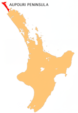
Aupouri Peninsula
Encyclopedia
Tombolo
A tombolo, from the Italian tombolo, derived from the Latin tumulus, meaning 'mound,' and sometimes translated as ayre , is a deposition landform in which an island is attached to the mainland by a narrow piece of land such as a spit or bar. Once attached, the island is then known as a tied island...
at the northern tip of the North Island
North Island
The North Island is one of the two main islands of New Zealand, separated from the much less populous South Island by Cook Strait. The island is in area, making it the world's 14th-largest island...
of New Zealand
New Zealand
New Zealand is an island country in the south-western Pacific Ocean comprising two main landmasses and numerous smaller islands. The country is situated some east of Australia across the Tasman Sea, and roughly south of the Pacific island nations of New Caledonia, Fiji, and Tonga...
. It projects between the Tasman Sea
Tasman Sea
The Tasman Sea is the large body of water between Australia and New Zealand, approximately across. It extends 2,800 km from north to south. It is a south-western segment of the South Pacific Ocean. The sea was named after the Dutch explorer Abel Janszoon Tasman, the first recorded European...
to the west and the Pacific Ocean
Pacific Ocean
The Pacific Ocean is the largest of the Earth's oceanic divisions. It extends from the Arctic in the north to the Southern Ocean in the south, bounded by Asia and Australia in the west, and the Americas in the east.At 165.2 million square kilometres in area, this largest division of the World...
to the east. It constitutes the northern part of the Far North District
Far North District
The Far North District of New Zealand, as its name suggests, is the northernmost district within New Zealand, consisting of the northern tip of the North Island. The current mayor is Wayne Brown.-Geography:...
, incorporating North Cape, Houhora
Houhora
Houhora is a locality and harbour on the east side of the Aupouri Peninsula of Northland, New Zealand. It is north of Kaitaia. Waihopo, Te Raupo, Pukenui, Raio and Houhora Heads are associated localities on the southern shores of the harbour. State Highway 1 passes through all these localities...
and the northern half of Awanui
Awanui
Awanui is a river port located 7 km north of Kaitaia, New Zealand. It lies at the south of the Aupouri Peninsula of the Northland Region. The Awanui River flows north to Rangaunu Bay. In the 1920s, kauri timber and gum from Kaitaia moved to the coast through Awanui.State Highway 1 and 10...
.
Overview
It is a peninsula on a peninsula, being part of the massive North Auckland PeninsulaNorth Auckland Peninsula
The North Auckland Peninsula, frequently referred to simply as the Northland Peninsula, is located in the far north of the North Island of New Zealand. The peninsula is easily confused with, though not the same as Northland Region, which occupies the top 80% of the peninsula...
which makes up nearly one twelfth of New Zealand's land area. Close to the northern town of Kaitaia
Kaitaia
Kaitaia is a town in the far north region of New Zealand, at the base of the Aupouri Peninsula which is about 160 km northwest of Whangarei. It is the last major settlement on the main road north to the capes and bays on the peninsula...
, the North Auckland Peninsula suddenly narrows from a width of 60 kilometres to a mere 10 kilometres, a width which it maintains approximately for the last 100 kilometres of its thrust to the north.
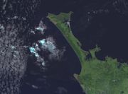
At the base of the Aupouri to the east is the natural inlet of the Rangaunu Harbour. Beyond this lies a further short peninsula and the broad sweep of Doubtless Bay. The east coast of the Aupouri Peninsula is dominated by Rangaunu Bay in the south and Great Exhibition Bay in the north. Towards its northern tip is the natural inlet of Parengarenga Harbour
Parengarenga Harbour
Parengarenga Harbour is a natural harbour close to the northernmost point on the North Island of New Zealand. Located at the northern end of the Aupouri Peninsula, it extends inland for over 10 kilometres, almost severing the northern tip of the island from the rest of the peninsula. The island's...
, beyond which lies North Cape
North Cape, New Zealand
North Cape is located at the northern end of the North Auckland Peninsula in the North Island of New Zealand . It is the northeastern tip of the Aupouri Peninsula and lies 30 km east of Cape Reinga. The name is sometimes used to refer just to the cape which is known in Māori as Otou and which...
.
The Aupouri Peninsula's best known feature lies on the other coast. Almost the entire length of the west coast is accounted for by the erroneously named 88 kilometre stretch of Ninety Mile Beach
Ninety Mile Beach, New Zealand
Ninety Mile Beach is a beach located on the western coast of the far north of the North Island of New Zealand. It stretches from just west of Kaitaia towards Cape Reinga along the Aupouri Peninsula. It begins close to the headland of Reef Point, to the west of Ahipara Bay, sweeping briefly...
.
At its northern end, the peninsula widens to 30 kilometres. Here are located the several capes which vie for the honour of the northernmost point on New Zealand's main islands: Cape Maria van Diemen
Cape Maria van Diemen
Cape Maria van Diemen is the westernmost point of the North Island of New Zealand. Being close to the northern tip of the Aupouri Peninsula, many people in New Zealand also incorrectly believe it to be the northernmost point...
, North Cape
North Cape, New Zealand
North Cape is located at the northern end of the North Auckland Peninsula in the North Island of New Zealand . It is the northeastern tip of the Aupouri Peninsula and lies 30 km east of Cape Reinga. The name is sometimes used to refer just to the cape which is known in Māori as Otou and which...
, Cape Reinga
Cape Reinga
Cape Reinga is the northwesternmost tip of the Aupouri Peninsula, at the northern end of the North Island of New Zealand. Cape Reinga is located over 100 km north of the nearest small town of Kaitaia. State Highway 1 extends all the way to the Cape, but until 2010 was unsealed gravel road for the...
and the Surville Cliffs
Surville Cliffs
The Surville Cliffs are the northernmost point of the mainland of New Zealand. They are situated on the North Cape of the North Island, 30 kilometres to the east of Cape Reinga , and three kilometres more northerly...
. The latter of these claims the title by a margin of only a few hundred metres. The Surville Cliffs lie at a latitude of 34° 23' 47" South. Only a handful of islands in the Three Kings
Three Kings Islands
The Three Kings Islands or Manawa Islands are a group of 13 islands about northwest of Cape Reinga, the northernmost point of the North Island of New Zealand, where the South Pacific Ocean and Tasman Sea converge. They measure about 4.86 km² in area...
and Kermadec
Kermadec Islands
The Kermadec Islands are a subtropical island arc in the South Pacific Ocean northeast of New Zealand's North Island, and a similar distance southwest of Tonga...
chains lie further north in New Zealand.
Althouth there are a number of settlements with over 100 people, including Te Hapua, Te Kao, Pukenui and Kaimaumau, the Peninsula is sparsely inhabited, with a total population of approximately 1600. For this reason, the area's roading is largely unsealed. The main road (State Highway 1) is now completely sealed, the final seal having been laid in April 2010. Ninety Mile Beach is also a designated highway (however, most rental contracts include this in "prohibited roads"). The nearest town to the capes at the tip of the peninsula is Kaitaia, 100 kilometres to the south.
It is named after Te Aupouri
Te Aupouri
Te Aupōuri is the northernmost Māori iwi , located north of Kaitaia, Northland, New Zealand, a region known as the Aupouri Peninsula.-The ancestral legend:...
, one of the Māori tribes that inhabits it.