

Geography of Manitoba
Encyclopedia
The Geography of Manitoba
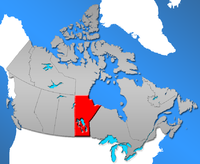
addresses the easternmost of the three prairie Canadian provinces, located in the longitudinal center of Canada
. Manitoba borders on Saskatchewan
to the west, Ontario
to the east, Nunavut
to the north, and the American states of North Dakota
and Minnesota
to the south. Although the border with Saskatchewan appears straight on large-scale maps, it actually has many right-angle corners that give the appearance of a slanted line. In elevation, Manitoba ranges from 490 ft (150 m) to 980 ft (300 m) above sea level
. Baldy Mountain, the highest elevation, is at 2727 ft (831 m). The northern sixty percent of the province is on the Canadian Shield
. The northernmost regions of Manitoba lie permafrost
(permanently frozen subsoil), and a section of tundra
bordering Hudson Bay
.
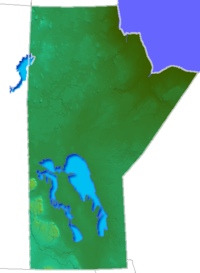
All waters in the province flow into Hudson Bay, due to its coastal area. Lake Winnipegosis
and Lake Winnipeg
are two of its largest lakes. Important rivers are the Red River
, Assiniboine River
, Nelson River
, and Churchill River
. Manitoba is the sixth largest Canadian province, and the eighth largest Canadian province by percentage of fresh water. The capital and largest city of the province is Winnipeg
; the province lies in the time zone UTC -6.
to tundra in the far north. Before settlement had occurred, a vast portion of southern Manitoba was either flood plain or swamp
. An extensive system for drainage ditches were required throughout south-central Manitoba to make the region suitable for cultivation.
Boreal forests of the southern part of the province have extensive Black Spruce
and White Spruce
forests. The tundra region of northern Manitoba exhibits more sparse Black Spruce forests whose tree heights are limited by the thin soils, permafrost underlayer and generally cold climate. In this region Polar Bear
s are found, denning
in the Wapusk National Park
and migrating to hunt for seals when pack ice forms on Hudson Bay
.
 Manitoba is bordered on the east by Ontario
, on the south by North Dakota
and Minnesota
, on the west by Saskatchewan
, and on the north by Nunavut
. Northeast Manitoba follows the Hudson Bay shoreline. Churchill
, on the Hudson Bay is the only port for the prairie provinces. The harbour serves as an open market for grain
.
Manitoba was the first Canadian province to be involved in the wheat
industry. There are only three ice-free months a year that allow for the shipments to be sent when shipping through the home port of Churchill.
The Canadian Shield
limits the amount of farming in the north, but there are some forestry and mining operations. The majority of the grain production is found in farms in the south.
Central and southern Manitoba is covered by lakes and rivers. Most of the population is centered in the southern third of the province.
Manitoba played a significant role in the European settlement of the Canadian west. Explorers arrived in Manitoba by the Hudson Bay, in search of a passage to China. As the fur trade
boomed, settlements rose up in the province to trading posts for the Natives and the Voyageurs (trappers). The settlement was not easy, and colonization slowed down for several years around 1816. In 1870, the Hudson's Bay Company
sold its huge domain to the confederation of Canada
.
Settlement inflated in Manitoba when the railway was built in the province and again in late 18th, early 19th century when government promoted settlement by European immigrants.
 The three dominant mountain ranges in Manitoba consist of Duck Mountains
, the Pembina Mountains
, and the Porcupine Mountains. They encompass natural beauty, tourist attractions, resorts, provincial parks, and many recreational activities.
The Duck mountain range is located in western Manitoba and stretches along the north-south Saskatchewan border. The highest point is Baldy Mountain, which reaches 2, 727 feet. Duck Mountain Provincial park
is located within the range and includes vivid scenery, tranquil Madge Lake, aspen
forests, beaches, campgrounds, and fishing.
The Pembina Mountains are located in southern Manitoba and extends over to Assiniboine River
and the North Dakota
border. Its highest point is 2,000 feet.
The Porcupine Mountains range is located in west-central Manitoba and extending along the Saskatchewan border. The highest point, which is Hart Mountain
near Swan River
, rises to 2,700 feet. The area is for diverse habitats, ranging from prairies to glacier
valleys to plateaus and well-known for its dense forest.
, which is one of the largest Paleoproterozoic
volcanic-hosted massive sulphide district
s in the world, containing 27 copper
-zinc
-(gold
) deposits from which more than 183 million tonnes of sulphide have been mined.
Manitoba
Manitoba is a Canadian prairie province with an area of . The province has over 110,000 lakes and has a largely continental climate because of its flat topography. Agriculture, mostly concentrated in the fertile southern and western parts of the province, is vital to the province's economy; other...
addresses the easternmost of the three prairie Canadian provinces, located in the longitudinal center of Canada
Canada
Canada is a North American country consisting of ten provinces and three territories. Located in the northern part of the continent, it extends from the Atlantic Ocean in the east to the Pacific Ocean in the west, and northward into the Arctic Ocean...
. Manitoba borders on Saskatchewan
Saskatchewan
Saskatchewan is a prairie province in Canada, which has an area of . Saskatchewan is bordered on the west by Alberta, on the north by the Northwest Territories, on the east by Manitoba, and on the south by the U.S. states of Montana and North Dakota....
to the west, Ontario
Ontario
Ontario is a province of Canada, located in east-central Canada. It is Canada's most populous province and second largest in total area. It is home to the nation's most populous city, Toronto, and the nation's capital, Ottawa....
to the east, Nunavut
Nunavut
Nunavut is the largest and newest federal territory of Canada; it was separated officially from the Northwest Territories on April 1, 1999, via the Nunavut Act and the Nunavut Land Claims Agreement Act, though the actual boundaries had been established in 1993...
to the north, and the American states of North Dakota
North Dakota
North Dakota is a state located in the Midwestern region of the United States of America, along the Canadian border. The state is bordered by Canada to the north, Minnesota to the east, South Dakota to the south and Montana to the west. North Dakota is the 19th-largest state by area in the U.S....
and Minnesota
Minnesota
Minnesota is a U.S. state located in the Midwestern United States. The twelfth largest state of the U.S., it is the twenty-first most populous, with 5.3 million residents. Minnesota was carved out of the eastern half of the Minnesota Territory and admitted to the Union as the thirty-second state...
to the south. Although the border with Saskatchewan appears straight on large-scale maps, it actually has many right-angle corners that give the appearance of a slanted line. In elevation, Manitoba ranges from 490 ft (150 m) to 980 ft (300 m) above sea level
Sea level
Mean sea level is a measure of the average height of the ocean's surface ; used as a standard in reckoning land elevation...
. Baldy Mountain, the highest elevation, is at 2727 ft (831 m). The northern sixty percent of the province is on the Canadian Shield
Canadian Shield
The Canadian Shield, also called the Laurentian Plateau, or Bouclier Canadien , is a vast geological shield covered by a thin layer of soil that forms the nucleus of the North American or Laurentia craton. It is an area mostly composed of igneous rock which relates to its long volcanic history...
. The northernmost regions of Manitoba lie permafrost
Permafrost
In geology, permafrost, cryotic soil or permafrost soil is soil at or below the freezing point of water for two or more years. Ice is not always present, as may be in the case of nonporous bedrock, but it frequently occurs and it may be in amounts exceeding the potential hydraulic saturation of...
(permanently frozen subsoil), and a section of tundra
Tundra
In physical geography, tundra is a biome where the tree growth is hindered by low temperatures and short growing seasons. The term tundra comes through Russian тундра from the Kildin Sami word tūndâr "uplands," "treeless mountain tract." There are three types of tundra: Arctic tundra, alpine...
bordering Hudson Bay
Hudson Bay
Hudson Bay , sometimes called Hudson's Bay, is a large body of saltwater in northeastern Canada. It drains a very large area, about , that includes parts of Ontario, Quebec, Saskatchewan, Alberta, most of Manitoba, southeastern Nunavut, as well as parts of North Dakota, South Dakota, Minnesota,...
.
All waters in the province flow into Hudson Bay, due to its coastal area. Lake Winnipegosis
Lake Winnipegosis
Lake Winnipegosis is a large lake in central North America, in Manitoba, Canada, some 300 km northwest of Winnipeg. It is Canada's eleventh-largest lake...
and Lake Winnipeg
Lake Winnipeg
Lake Winnipeg is a large, lake in central North America, in the province of Manitoba, Canada, with its southern tip about north of the city of Winnipeg...
are two of its largest lakes. Important rivers are the Red River
Red River of the North
The Red River is a North American river. Originating at the confluence of the Bois de Sioux and Otter Tail rivers in the United States, it flows northward through the Red River Valley and forms the border between the U.S. states of Minnesota and North Dakota before continuing into Manitoba, Canada...
, Assiniboine River
Assiniboine River
The Assiniboine River is a river that runs through the prairies of Western Canada in Saskatchewan and Manitoba. It is a tributary of the Red River. The Assiniboine is a typical meandering river with a single main channel embanked within a flat, shallow valley in some places and a steep valley in...
, Nelson River
Nelson River
The Nelson River is a river of north-central North America, in the Canadian province of Manitoba. Its full length is , it has mean discharge of , and has a drainage basin of , of which is in the United States...
, and Churchill River
Churchill River (Hudson Bay)
The Churchill River is a major river in Alberta, Saskatchewan and Manitoba, Canada. From the head of the Churchill Lake it is 1,609 km long. It was named after John Churchill, 1st Duke of Marlborough and governor of the Hudson's Bay Company from 1685 to 1691...
. Manitoba is the sixth largest Canadian province, and the eighth largest Canadian province by percentage of fresh water. The capital and largest city of the province is Winnipeg
Winnipeg
Winnipeg is the capital and largest city of Manitoba, Canada, and is the primary municipality of the Winnipeg Capital Region, with more than half of Manitoba's population. It is located near the longitudinal centre of North America, at the confluence of the Red and Assiniboine Rivers .The name...
; the province lies in the time zone UTC -6.
Environmental geography
Manitoba has an extreme climate, but southern latitudes allow agriculture. The northern area of the region ranges from coniferous forests to muskegMuskeg
Muskeg is an acidic soil type common in Arctic and boreal areas, although it is found in other northern climates as well. Muskeg is approximately synonymous with bogland but muskeg is the standard term in Western Canada and Alaska, while 'bog' is common elsewhere. The term is of Cree origin, maskek...
to tundra in the far north. Before settlement had occurred, a vast portion of southern Manitoba was either flood plain or swamp
Swamp
A swamp is a wetland with some flooding of large areas of land by shallow bodies of water. A swamp generally has a large number of hammocks, or dry-land protrusions, covered by aquatic vegetation, or vegetation that tolerates periodical inundation. The two main types of swamp are "true" or swamp...
. An extensive system for drainage ditches were required throughout south-central Manitoba to make the region suitable for cultivation.
Boreal forests of the southern part of the province have extensive Black Spruce
Black Spruce
Picea mariana is a species of spruce native to northern North America, from Newfoundland west to Alaska, and south to northern New York, Minnesota and central British Columbia...
and White Spruce
White Spruce
Picea glauca is a species of spruce native to boreal forests in the north of North America, from central Alaska east to Newfoundland, and south to northern Montana, Minnesota, Wisconsin, Michigan, upstate New York, Vermont, New Hampshire, and Maine; there is also an isolated population in the...
forests. The tundra region of northern Manitoba exhibits more sparse Black Spruce forests whose tree heights are limited by the thin soils, permafrost underlayer and generally cold climate. In this region Polar Bear
Polar Bear
The polar bear is a bear native largely within the Arctic Circle encompassing the Arctic Ocean, its surrounding seas and surrounding land masses. It is the world's largest land carnivore and also the largest bear, together with the omnivorous Kodiak Bear, which is approximately the same size...
s are found, denning
Maternity den
A maternity den, in the animal kingdom, is a lair where the mother gives birth and nurtures the young, when they are in a vulnerable life stage. While such dens are typically subterranean, they may also be snow caves or simply beneath rock ledges. Characteristically there is an entrance, and...
in the Wapusk National Park
Wapusk National Park
Wapusk National Park is Canada's 37th national park, established in 1996. The park is located in the Hudson Plains ecozone, 45 km south of Churchill in north-east Manitoba, Canada, on the shores of Hudson Bay. Access to the park is limited due to its remote location and an effort to preserve...
and migrating to hunt for seals when pack ice forms on Hudson Bay
Hudson Bay
Hudson Bay , sometimes called Hudson's Bay, is a large body of saltwater in northeastern Canada. It drains a very large area, about , that includes parts of Ontario, Quebec, Saskatchewan, Alberta, most of Manitoba, southeastern Nunavut, as well as parts of North Dakota, South Dakota, Minnesota,...
.
Historical geography
Ontario
Ontario is a province of Canada, located in east-central Canada. It is Canada's most populous province and second largest in total area. It is home to the nation's most populous city, Toronto, and the nation's capital, Ottawa....
, on the south by North Dakota
North Dakota
North Dakota is a state located in the Midwestern region of the United States of America, along the Canadian border. The state is bordered by Canada to the north, Minnesota to the east, South Dakota to the south and Montana to the west. North Dakota is the 19th-largest state by area in the U.S....
and Minnesota
Minnesota
Minnesota is a U.S. state located in the Midwestern United States. The twelfth largest state of the U.S., it is the twenty-first most populous, with 5.3 million residents. Minnesota was carved out of the eastern half of the Minnesota Territory and admitted to the Union as the thirty-second state...
, on the west by Saskatchewan
Saskatchewan
Saskatchewan is a prairie province in Canada, which has an area of . Saskatchewan is bordered on the west by Alberta, on the north by the Northwest Territories, on the east by Manitoba, and on the south by the U.S. states of Montana and North Dakota....
, and on the north by Nunavut
Nunavut
Nunavut is the largest and newest federal territory of Canada; it was separated officially from the Northwest Territories on April 1, 1999, via the Nunavut Act and the Nunavut Land Claims Agreement Act, though the actual boundaries had been established in 1993...
. Northeast Manitoba follows the Hudson Bay shoreline. Churchill
Churchill, Manitoba
Churchill is a town on the shore of Hudson Bay in Manitoba, Canada. It is most famous for the many polar bears that move toward the shore from inland in the autumn, leading to the nickname "Polar Bear Capital of the World" that has helped its growing tourism industry.-History:A variety of nomadic...
, on the Hudson Bay is the only port for the prairie provinces. The harbour serves as an open market for grain
GRAIN
GRAIN is a small international non-profit organisation that works to support small farmers and social movements in their struggles for community-controlled and biodiversity-based food systems. Our support takes the form of independent research and analysis, networking at local, regional and...
.
Manitoba was the first Canadian province to be involved in the wheat
Wheat
Wheat is a cereal grain, originally from the Levant region of the Near East, but now cultivated worldwide. In 2007 world production of wheat was 607 million tons, making it the third most-produced cereal after maize and rice...
industry. There are only three ice-free months a year that allow for the shipments to be sent when shipping through the home port of Churchill.
The Canadian Shield
Canadian Shield
The Canadian Shield, also called the Laurentian Plateau, or Bouclier Canadien , is a vast geological shield covered by a thin layer of soil that forms the nucleus of the North American or Laurentia craton. It is an area mostly composed of igneous rock which relates to its long volcanic history...
limits the amount of farming in the north, but there are some forestry and mining operations. The majority of the grain production is found in farms in the south.
Central and southern Manitoba is covered by lakes and rivers. Most of the population is centered in the southern third of the province.
Manitoba played a significant role in the European settlement of the Canadian west. Explorers arrived in Manitoba by the Hudson Bay, in search of a passage to China. As the fur trade
Fur trade
The fur trade is a worldwide industry dealing in the acquisition and sale of animal fur. Since the establishment of world market for in the early modern period furs of boreal, polar and cold temperate mammalian animals have been the most valued...
boomed, settlements rose up in the province to trading posts for the Natives and the Voyageurs (trappers). The settlement was not easy, and colonization slowed down for several years around 1816. In 1870, the Hudson's Bay Company
Hudson's Bay Company
The Hudson's Bay Company , abbreviated HBC, or "The Bay" is the oldest commercial corporation in North America and one of the oldest in the world. A fur trading business for much of its existence, today Hudson's Bay Company owns and operates retail stores throughout Canada...
sold its huge domain to the confederation of Canada
Canadian Confederation
Canadian Confederation was the process by which the federal Dominion of Canada was formed on July 1, 1867. On that day, three British colonies were formed into four Canadian provinces...
.
Settlement inflated in Manitoba when the railway was built in the province and again in late 18th, early 19th century when government promoted settlement by European immigrants.
Mountain ranges of Manitoba
Duck Mountain Provincial Park (Manitoba)
Duck Mountain Provincial Park is a 600 square kilometre forest in western Manitoba. It is not to be confused with Saskatchewan's Duck Mountain Provincial Park, located just across the Manitoba/Saskatchewan boundary....
, the Pembina Mountains
Pembina Escarpment
The Manitoba Escarpment is a scarp that marks the boundary of glacial Lake Agassiz. It occurs in South Dakota, North Dakota, and Manitoba....
, and the Porcupine Mountains. They encompass natural beauty, tourist attractions, resorts, provincial parks, and many recreational activities.
The Duck mountain range is located in western Manitoba and stretches along the north-south Saskatchewan border. The highest point is Baldy Mountain, which reaches 2, 727 feet. Duck Mountain Provincial park
Duck Mountain Provincial Park (Manitoba)
Duck Mountain Provincial Park is a 600 square kilometre forest in western Manitoba. It is not to be confused with Saskatchewan's Duck Mountain Provincial Park, located just across the Manitoba/Saskatchewan boundary....
is located within the range and includes vivid scenery, tranquil Madge Lake, aspen
Aspen
Populus section Populus, of the Populus genus, includes the aspen trees and the white poplar Populus alba. The five typical aspens are all native to cold regions with cool summers, in the north of the Northern Hemisphere, extending south at high altitudes in the mountains. The White Poplar, by...
forests, beaches, campgrounds, and fishing.
The Pembina Mountains are located in southern Manitoba and extends over to Assiniboine River
Assiniboine River
The Assiniboine River is a river that runs through the prairies of Western Canada in Saskatchewan and Manitoba. It is a tributary of the Red River. The Assiniboine is a typical meandering river with a single main channel embanked within a flat, shallow valley in some places and a steep valley in...
and the North Dakota
North Dakota
North Dakota is a state located in the Midwestern region of the United States of America, along the Canadian border. The state is bordered by Canada to the north, Minnesota to the east, South Dakota to the south and Montana to the west. North Dakota is the 19th-largest state by area in the U.S....
border. Its highest point is 2,000 feet.
The Porcupine Mountains range is located in west-central Manitoba and extending along the Saskatchewan border. The highest point, which is Hart Mountain
Hart Mountain (Manitoba)
At 823 metres, Hart Mountain in Manitoba is the highest peak in the Porcupine Hills of central Canada. It is located 43 km NNW of Swan River....
near Swan River
Swan River, Manitoba
-Economy:The economic base of the town lies in agriculture and forestry along with support industries for same.Almost fifty percent of the surrounding area is under cultivation, most of which is seeded to cereal grain, oilseeds, and other specialty crops. Wheat, rye, barley, oats, flax, and canola...
, rises to 2,700 feet. The area is for diverse habitats, ranging from prairies to glacier
Glacier
A glacier is a large persistent body of ice that forms where the accumulation of snow exceeds its ablation over many years, often centuries. At least 0.1 km² in area and 50 m thick, but often much larger, a glacier slowly deforms and flows due to stresses induced by its weight...
valleys to plateaus and well-known for its dense forest.
Geology
In central Manitoba lies the Flin Flon greenstone beltFlin Flon greenstone belt
The Flin Flon greenstone belt, also referred to as the Flin Flon-Snow Lake greenstone belt, is a Precambrian greenstone belt located in the central area of Manitoba and east-central Saskatchewan, Canada . It lies in the central portion of the Trans-Hudson orogeny and was formed by arc volcanism...
, which is one of the largest Paleoproterozoic
Paleoproterozoic
The Paleoproterozoic is the first of the three sub-divisions of the Proterozoic occurring between . This is when the continents first stabilized...
volcanic-hosted massive sulphide district
Volcanogenic massive sulfide ore deposit
Volcanogenic massive sulfide ore deposits are a type of metal sulfide ore deposit, mainly Cu-Zn-Pb which are associated with and created by volcanic-associated hydrothermal events in submarine environments....
s in the world, containing 27 copper
Copper
Copper is a chemical element with the symbol Cu and atomic number 29. It is a ductile metal with very high thermal and electrical conductivity. Pure copper is soft and malleable; an exposed surface has a reddish-orange tarnish...
-zinc
Zinc
Zinc , or spelter , is a metallic chemical element; it has the symbol Zn and atomic number 30. It is the first element in group 12 of the periodic table. Zinc is, in some respects, chemically similar to magnesium, because its ion is of similar size and its only common oxidation state is +2...
-(gold
Gold
Gold is a chemical element with the symbol Au and an atomic number of 79. Gold is a dense, soft, shiny, malleable and ductile metal. Pure gold has a bright yellow color and luster traditionally considered attractive, which it maintains without oxidizing in air or water. Chemically, gold is a...
) deposits from which more than 183 million tonnes of sulphide have been mined.
Statistics
Location and boundary
- Area: 250,946 mi² / 649,950 km²
- Land Surface: 211721 mi² / 548,360 km²
- North to South: 761 miles / 1225 km
- Width (South): 279 miles / 449 km
- North Boundary (Width): 260 miles / 418 km
- Coastline: 400 miles / 645 km
- Water surface: 39,225 mi² / 101,593 km²
- Widest Point: 493 miles / 793 km
Population
- Total population 1,150,000 (2001)
- Population density 1.78 people/km² (ranked 5th among Canadian provinces)
See also
- Geography of CanadaGeography of CanadaThe geography of Canada is vast and diverse. Occupying most of the northern portion of North America , Canada is the world's second largest country in total area....
- List of highest points of Canadian provinces and territories
Line note references
External links
- Manitoba Provincial Unit Study
- Manitoba Geology
- Answers.com for Manitoba
- Manitoba Geography
- Manitoba historical geography
- Mountain ranges
- Prairie:Manitoba: Strathclair by John Welsted, John Everitt and Christoph Stadel of University of Manitoba Press