

Geography of Côte d'Ivoire
Encyclopedia
Côte d'Ivoire
The Republic of Côte d'Ivoire or Ivory Coast is a country in West Africa. It has an area of , and borders the countries Liberia, Guinea, Mali, Burkina Faso and Ghana; its southern boundary is along the Gulf of Guinea. The country's population was 15,366,672 in 1998 and was estimated to be...
(the Ivory Coast) is a sub-Saharan
Sub-Saharan Africa
Sub-Saharan Africa as a geographical term refers to the area of the African continent which lies south of the Sahara. A political definition of Sub-Saharan Africa, instead, covers all African countries which are fully or partially located south of the Sahara...
nation in southern West Africa
West Africa
West Africa or Western Africa is the westernmost region of the African continent. Geopolitically, the UN definition of Western Africa includes the following 16 countries and an area of approximately 5 million square km:-Flags of West Africa:...
located at 8 00°N, 5 00°W. The country is shaped like a square
Square (geometry)
In geometry, a square is a regular quadrilateral. This means that it has four equal sides and four equal angles...
and borders the Gulf of Guinea
Gulf of Guinea
The Gulf of Guinea is the northeasternmost part of the tropical Atlantic Ocean between Cape Lopez in Gabon, north and west to Cape Palmas in Liberia. The intersection of the Equator and Prime Meridian is in the gulf....
on the north Atlantic Ocean
Atlantic Ocean
The Atlantic Ocean is the second-largest of the world's oceanic divisions. With a total area of about , it covers approximately 20% of the Earth's surface and about 26% of its water surface area...
to the south (515 km of coastline) and five other Africa
Africa
Africa is the world's second largest and second most populous continent, after Asia. At about 30.2 million km² including adjacent islands, it covers 6% of the Earth's total surface area and 20.4% of the total land area...
n nations on the other three sides, with a total of 3,110 km of border
Border
Borders define geographic boundaries of political entities or legal jurisdictions, such as governments, sovereign states, federated states and other subnational entities. Some borders—such as a state's internal administrative borders, or inter-state borders within the Schengen Area—are open and...
s: Liberia
Liberia
Liberia , officially the Republic of Liberia, is a country in West Africa. It is bordered by Sierra Leone on the west, Guinea on the north and Côte d'Ivoire on the east. Liberia's coastline is composed of mostly mangrove forests while the more sparsely populated inland consists of forests that open...
to the southwest (716 km), Guinea
Guinea
Guinea , officially the Republic of Guinea , is a country in West Africa. Formerly known as French Guinea , it is today sometimes called Guinea-Conakry to distinguish it from its neighbour Guinea-Bissau. Guinea is divided into eight administrative regions and subdivided into thirty-three prefectures...
to the northwest (610 km), Mali
Mali
Mali , officially the Republic of Mali , is a landlocked country in Western Africa. Mali borders Algeria on the north, Niger on the east, Burkina Faso and the Côte d'Ivoire on the south, Guinea on the south-west, and Senegal and Mauritania on the west. Its size is just over 1,240,000 km² with...
to the north-northwest (532 km), Burkina Faso
Burkina Faso
Burkina Faso – also known by its short-form name Burkina – is a landlocked country in west Africa. It is surrounded by six countries: Mali to the north, Niger to the east, Benin to the southeast, Togo and Ghana to the south, and Côte d'Ivoire to the southwest.Its size is with an estimated...
to the north-northeast, and Ghana
Ghana
Ghana , officially the Republic of Ghana, is a country located in West Africa. It is bordered by Côte d'Ivoire to the west, Burkina Faso to the north, Togo to the east, and the Gulf of Guinea to the south...
to the east (668 km). In total, Côte d'Ivoire comprises 322,460 km2, of which 318,000 km2 is land and 4,460 km2 is water, which makes the country slightly larger than the U.S. state
U.S. state
A U.S. state is any one of the 50 federated states of the United States of America that share sovereignty with the federal government. Because of this shared sovereignty, an American is a citizen both of the federal entity and of his or her state of domicile. Four states use the official title of...
of New Mexico
New Mexico
New Mexico is a state located in the southwest and western regions of the United States. New Mexico is also usually considered one of the Mountain States. With a population density of 16 per square mile, New Mexico is the sixth-most sparsely inhabited U.S...
, or about the size of Germany
Germany
Germany , officially the Federal Republic of Germany , is a federal parliamentary republic in Europe. The country consists of 16 states while the capital and largest city is Berlin. Germany covers an area of 357,021 km2 and has a largely temperate seasonal climate...
.
Maritime claims
Côte d'Ivoire makes maritime claims of 200 nmi (370.4 km; 230.2 mi) as an exclusive economic zoneExclusive Economic Zone
Under the law of the sea, an exclusive economic zone is a seazone over which a state has special rights over the exploration and use of marine resources, including production of energy from water and wind. It stretches from the seaward edge of the state's territorial sea out to 200 nautical...
, 12 nmi (22.2 km; 13.8 mi) of territorial sea, and a 200 nmi (370.4 km; 230.2 mi) continental shelf
Continental shelf
The continental shelf is the extended perimeter of each continent and associated coastal plain. Much of the shelf was exposed during glacial periods, but is now submerged under relatively shallow seas and gulfs, and was similarly submerged during other interglacial periods. The continental margin,...
.
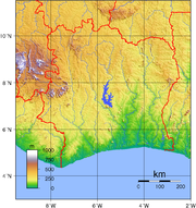
Terrain and topography
Côte d'Ivoire's terrainTerrain
Terrain, or land relief, is the vertical and horizontal dimension of land surface. When relief is described underwater, the term bathymetry is used...
can generally be described as a large plateau
Plateau
In geology and earth science, a plateau , also called a high plain or tableland, is an area of highland, usually consisting of relatively flat terrain. A highly eroded plateau is called a dissected plateau...
rising gradually from sea level
Sea level
Mean sea level is a measure of the average height of the ocean's surface ; used as a standard in reckoning land elevation...
in the south to almost 500 m elevation
Elevation
The elevation of a geographic location is its height above a fixed reference point, most commonly a reference geoid, a mathematical model of the Earth's sea level as an equipotential gravitational surface ....
in the north. The nation's natural resources have made it into a comparatively prosperous nation in the African economy
Economy of Africa
The economy of Africa consists of the trade, industry, and resources of the people of Africa. , approximately 922 million people were living in 54 different countries. Africa is by far the world's poorest inhabited continent...
.
The southeastern region of Côte d'Ivoire is marked by coastal inland lagoons that starts at the Ghanaian border and stretch 300 km (186 mi) along the eastern half of the coast. The southern region, especially the southwest, is covered with dense tropical moist forest. The Eastern Guinean forests
Eastern Guinean forests
The Eastern Guinean forests are a tropical moist broadleaf forest ecoregion of West Africa. The ecoregion includes the lowland forests extending from the Gulf of Guinea a few hundred kilometers inland, from western Côte d'Ivoire to the western shore of Lake Volta in Ghana. A few small enclaves lie...
extend from the Sassandra River across the south-central and southeast portion of Côte d'Ivoire and east into Ghana
Ghana
Ghana , officially the Republic of Ghana, is a country located in West Africa. It is bordered by Côte d'Ivoire to the west, Burkina Faso to the north, Togo to the east, and the Gulf of Guinea to the south...
, while the Western Guinean lowland forests
Western Guinean lowland forests
The Western Guinean lowland forests are a tropical moist broadleaf forest ecoregion of West Africa. The ecoregion includes the lowland forests extending from the Atlantic Ocean a few hundred kilometers inland, and from western Côte d'Ivoire across Liberia, southeastern Guinea, most of Sierra Leone,...
extend west from the Sassandra River
Sassandra River
The Sassandra River is a river of western Côte d'Ivoire in West Africa. It is formed by the confluence of the Tienba River, which originates in the highlands of northwestern Côte d'Ivoire, and the Gouan River , which originates to the west in the highlands of Guinea...
into Liberia
Liberia
Liberia , officially the Republic of Liberia, is a country in West Africa. It is bordered by Sierra Leone on the west, Guinea on the north and Côte d'Ivoire on the east. Liberia's coastline is composed of mostly mangrove forests while the more sparsely populated inland consists of forests that open...
and southeastern Guinea
Guinea
Guinea , officially the Republic of Guinea , is a country in West Africa. Formerly known as French Guinea , it is today sometimes called Guinea-Conakry to distinguish it from its neighbour Guinea-Bissau. Guinea is divided into eight administrative regions and subdivided into thirty-three prefectures...
. The mountains of Dix-Huit Montagnes
Dix-Huit Montagnes
Dix-Huit Montagnes is one of the 19 regions of Côte d'Ivoire. The region's capital is Man. Covering 16,600 km², its population is 1,125,800....
region, in the west of the country near the border with Guinea and Liberia, are home to the Guinean montane forests.
The Guinean forest-savanna mosaic
Guinean forest-savanna mosaic
The Guinean forest-savanna mosaic is an ecoregion of West Africa, a band of interlaced forest, savanna, and grassland running east to west and dividing the tropical moist forests near the coast from the West Sudanian savanna of the interior.-Setting:...
belt extends across the middle of the country from east to west, and is the transition zone between the coastal forests and the interior savanna
Savanna
A savanna, or savannah, is a grassland ecosystem characterized by the trees being sufficiently small or widely spaced so that the canopy does not close. The open canopy allows sufficient light to reach the ground to support an unbroken herbaceous layer consisting primarily of C4 grasses.Some...
s. The forest-savanna mosaic interlaces forest, savanna and grassland habitats. Northern Côte d'Ivoire is part of the West Sudanian Savanna ecoregion of the Tropical and subtropical grasslands, savannas, and shrublands
Tropical and subtropical grasslands, savannas, and shrublands
Tropical and subtropical grasslands, savannas, and shrublands are a grassland terrestrial biome located in semi-arid to semi-humid climate regions of subtropical and tropical latitudes. Grasslands are dominated by grass and other herbaceous plants. Savannas are grasslands with scattered trees...
biome
Biome
Biomes are climatically and geographically defined as similar climatic conditions on the Earth, such as communities of plants, animals, and soil organisms, and are often referred to as ecosystems. Some parts of the earth have more or less the same kind of abiotic and biotic factors spread over a...
. It is a zone of lateritic or sandy soil
Soil
Soil is a natural body consisting of layers of mineral constituents of variable thicknesses, which differ from the parent materials in their morphological, physical, chemical, and mineralogical characteristics...
s, with vegetation
Vegetation
Vegetation is a general term for the plant life of a region; it refers to the ground cover provided by plants. It is a general term, without specific reference to particular taxa, life forms, structure, spatial extent, or any other specific botanical or geographic characteristics. It is broader...
decreasing from south to north.
The terrain is mostly flat to undulating plain
Plain
In geography, a plain is land with relatively low relief, that is flat or gently rolling. Prairies and steppes are types of plains, and the archetype for a plain is often thought of as a grassland, but plains in their natural state may also be covered in shrublands, woodland and forest, or...
s, with mountain
Mountain
Image:Himalaya_annotated.jpg|thumb|right|The Himalayan mountain range with Mount Everestrect 58 14 160 49 Chomo Lonzorect 200 28 335 52 Makalurect 378 24 566 45 Mount Everestrect 188 581 920 656 Tibetan Plateaurect 250 406 340 427 Rong River...
s in the northwest. The lowest elevation in Côte d'Ivoire is at sea level on the coasts. The highest elevation is Mount Nimba
Mount Nimba
Mount Richard-Molard is a mountain along the border of Côte d'Ivoire and Guinea in West Africa. At 1,752 m it is the highest point in both nations. The mountain is the highest peak of the Nimba Range , straddling the border between the two countries and Liberia...
, at 1752 metres (5,748 ft) in the far west of the country along the border with Guinea and Liberia.
Climate
The climateClimate
Climate encompasses the statistics of temperature, humidity, atmospheric pressure, wind, rainfall, atmospheric particle count and other meteorological elemental measurements in a given region over long periods...
of Côte d'Ivoire is generally warm and humid, ranging from equator
Equator
An equator is the intersection of a sphere's surface with the plane perpendicular to the sphere's axis of rotation and containing the sphere's center of mass....
ial in the southern coasts to tropical
Tropics
The tropics is a region of the Earth surrounding the Equator. It is limited in latitude by the Tropic of Cancer in the northern hemisphere at approximately N and the Tropic of Capricorn in the southern hemisphere at S; these latitudes correspond to the axial tilt of the Earth...
in the middle and semiarid in the far north. There are three seasons: warm and dry (November to March), hot and dry (March to May), and hot and wet (June to October). Temperatures average between 25 and 32 °C (77 and 89.6 °F) and range from 10 to 40 °C (50 to 104 °F).
Crops and natural resources
Côte d'Ivoire's also has a large timberTimber
Timber may refer to:* Timber, a term common in the United Kingdom and Australia for wood materials * Timber, Oregon, an unincorporated community in the U.S...
industry due to its large forest
Forest
A forest, also referred to as a wood or the woods, is an area with a high density of trees. As with cities, depending where you are in the world, what is considered a forest may vary significantly in size and have various classification according to how and what of the forest is composed...
coverage. The nation's hardwood
Hardwood
Hardwood is wood from angiosperm trees . It may also be used for those trees themselves: these are usually broad-leaved; in temperate and boreal latitudes they are mostly deciduous, but in tropics and subtropics mostly evergreen.Hardwood contrasts with softwood...
exports match that of Brazil
Brazil
Brazil , officially the Federative Republic of Brazil , is the largest country in South America. It is the world's fifth largest country, both by geographical area and by population with over 192 million people...
. In recent years there has been much concern about the rapid rate of deforestation
Deforestation
Deforestation is the removal of a forest or stand of trees where the land is thereafter converted to a nonforest use. Examples of deforestation include conversion of forestland to farms, ranches, or urban use....
. Rainforest
Rainforest
Rainforests are forests characterized by high rainfall, with definitions based on a minimum normal annual rainfall of 1750-2000 mm...
s are being destroyed at a rate sometimes cited as the highest in the world. The only forest left completely untouched in Côte d'Ivoire is Taï National Park
Taï National Park
Taï National Park is a national park in Côte d'Ivoire containing one of the last areas of primary rainforest in West Africa. It was inscribed as a World Heritage Site in 1982 due to the breadth of its flora and fauna...
(Parc National de Taï), a 3600 km² (1,390 sq mi) area in the country's far southwest that is home to over 150 endemic
Endemic (ecology)
Endemism is the ecological state of being unique to a defined geographic location, such as an island, nation or other defined zone, or habitat type; organisms that are indigenous to a place are not endemic to it if they are also found elsewhere. For example, all species of lemur are endemic to the...
species and many other endangered species
Endangered species
An endangered species is a population of organisms which is at risk of becoming extinct because it is either few in numbers, or threatened by changing environmental or predation parameters...
such as the Pygmy Hippopotamus
Pygmy Hippopotamus
The pygmy hippopotamus is a large mammal native to the forests and swamps of western Africa . The pygmy hippo is reclusive and nocturnal...
and 11 species of monkey
Monkey
A monkey is a primate, either an Old World monkey or a New World monkey. There are about 260 known living species of monkey. Many are arboreal, although there are species that live primarily on the ground, such as baboons. Monkeys are generally considered to be intelligent. Unlike apes, monkeys...
s.
Eight percent of the country is arable land
Arable land
In geography and agriculture, arable land is land that can be used for growing crops. It includes all land under temporary crops , temporary meadows for mowing or pasture, land under market and kitchen gardens and land temporarily fallow...
. Côte d'Ivoire is the world's largest producer of cocoa, a major national cash crop
Cash crop
In agriculture, a cash crop is a crop which is grown for profit.The term is used to differentiate from subsistence crops, which are those fed to the producer's own livestock or grown as food for the producer's family...
. Other chief crops include coffee
Coffee
Coffee is a brewed beverage with a dark,init brooo acidic flavor prepared from the roasted seeds of the coffee plant, colloquially called coffee beans. The beans are found in coffee cherries, which grow on trees cultivated in over 70 countries, primarily in equatorial Latin America, Southeast Asia,...
, banana
Banana
Banana is the common name for herbaceous plants of the genus Musa and for the fruit they produce. Bananas come in a variety of sizes and colors when ripe, including yellow, purple, and red....
s, and oil palm
Oil palm
The oil palms comprise two species of the Arecaceae, or palm family. They are used in commercial agriculture in the production of palm oil. The African Oil Palm Elaeis guineensis is native to West Africa, occurring between Angola and Gambia, while the American Oil Palm Elaeis oleifera is native to...
s, which produce palm oil
Palm oil
Palm oil, coconut oil and palm kernel oil are edible plant oils derived from the fruits of palm trees. Palm oil is extracted from the pulp of the fruit of the oil palm Elaeis guineensis; palm kernel oil is derived from the kernel of the oil palm and coconut oil is derived from the kernel of the...
and kernels. Natural resource
Natural resource
Natural resources occur naturally within environments that exist relatively undisturbed by mankind, in a natural form. A natural resource is often characterized by amounts of biodiversity and geodiversity existent in various ecosystems....
s include petroleum
Petroleum
Petroleum or crude oil is a naturally occurring, flammable liquid consisting of a complex mixture of hydrocarbons of various molecular weights and other liquid organic compounds, that are found in geologic formations beneath the Earth's surface. Petroleum is recovered mostly through oil drilling...
, natural gas
Natural gas
Natural gas is a naturally occurring gas mixture consisting primarily of methane, typically with 0–20% higher hydrocarbons . It is found associated with other hydrocarbon fuel, in coal beds, as methane clathrates, and is an important fuel source and a major feedstock for fertilizers.Most natural...
, diamond
Diamond
In mineralogy, diamond is an allotrope of carbon, where the carbon atoms are arranged in a variation of the face-centered cubic crystal structure called a diamond lattice. Diamond is less stable than graphite, but the conversion rate from diamond to graphite is negligible at ambient conditions...
s, manganese
Manganese
Manganese is a chemical element, designated by the symbol Mn. It has the atomic number 25. It is found as a free element in nature , and in many minerals...
, iron
Iron
Iron is a chemical element with the symbol Fe and atomic number 26. It is a metal in the first transition series. It is the most common element forming the planet Earth as a whole, forming much of Earth's outer and inner core. It is the fourth most common element in the Earth's crust...
, cobalt
Cobalt
Cobalt is a chemical element with symbol Co and atomic number 27. It is found naturally only in chemically combined form. The free element, produced by reductive smelting, is a hard, lustrous, silver-gray metal....
, bauxite
Bauxite
Bauxite is an aluminium ore and is the main source of aluminium. This form of rock consists mostly of the minerals gibbsite Al3, boehmite γ-AlO, and diaspore α-AlO, in a mixture with the two iron oxides goethite and hematite, the clay mineral kaolinite, and small amounts of anatase TiO2...
, copper
Copper
Copper is a chemical element with the symbol Cu and atomic number 29. It is a ductile metal with very high thermal and electrical conductivity. Pure copper is soft and malleable; an exposed surface has a reddish-orange tarnish...
, and hydropower
Hydropower
Hydropower, hydraulic power, hydrokinetic power or water power is power that is derived from the force or energy of falling water, which may be harnessed for useful purposes. Since ancient times, hydropower has been used for irrigation and the operation of various mechanical devices, such as...
.
There are more foreigners than Ivorians. Foreigners currently make up 67% of the country's population.
Natural hazards
Natural hazardNatural hazard
A natural hazard is a threat of a naturally occurring event that will have a negative effect on people or the environment. Many natural hazards are interrelated, e.g. earthquakes can cause tsunamis and drought can lead directly to famine. It is possible that some natural hazards are...
s include the heavy surf and the lack of natural harbors on the coast; during the rainy season torrential flood
Flood
A flood is an overflow of an expanse of water that submerges land. The EU Floods directive defines a flood as a temporary covering by water of land not normally covered by water...
ing is a danger.
Extreme points
This is a list of the extreme points of Cote d'IvoireCôte d'Ivoire
The Republic of Côte d'Ivoire or Ivory Coast is a country in West Africa. It has an area of , and borders the countries Liberia, Guinea, Mali, Burkina Faso and Ghana; its southern boundary is along the Gulf of Guinea. The country's population was 15,366,672 in 1998 and was estimated to be...
, the points that are farther north, south, east or west than any other location.
- Northern-most point – the point at which the border with MaliMaliMali , officially the Republic of Mali , is a landlocked country in Western Africa. Mali borders Algeria on the north, Niger on the east, Burkina Faso and the Côte d'Ivoire on the south, Guinea on the south-west, and Senegal and Mauritania on the west. Its size is just over 1,240,000 km² with...
enters the Bagoé riverBagoé RiverThe Bagoé River is a tributary of the Bani River in western Africa. It flows through northern Côte d'Ivoire and southern Mali and forms part of the international boundary between the two states....
, Savanes Region, the SahelSahelThe Sahel is the ecoclimatic and biogeographic zone of transition between the Sahara desert in the North and the Sudanian Savannas in the south.It stretches across the North African continent between the Atlantic Ocean and the Red Sea....
. - Eastern-most point – unnamed location on the border with GhanaGhanaGhana , officially the Republic of Ghana, is a country located in West Africa. It is bordered by Côte d'Ivoire to the west, Burkina Faso to the north, Togo to the east, and the Gulf of Guinea to the south...
south-west of the town of Tanbi, ZanzanZanzanZanzan is one of the 19 regions of Côte d'Ivoire, West Africa. The region's capital is Bondoukou. Covering 38,000 km², its population is 839,000.The region is divided into three departments: Bondoukou, Bouna, and Tanda.... - Southern-most point – Boubré, Bas-SassandraBas-SassandraBas-Sassandra is one of the 19 regions of Côte d'Ivoire. The region's capital is San-Pédro. It covers 25,800 km².The region is divided into four departments: San Pédro, Sassandra, Soubré, and Tabou....
region - Western-most point - unnamed location on the border with LiberiaLiberiaLiberia , officially the Republic of Liberia, is a country in West Africa. It is bordered by Sierra Leone on the west, Guinea on the north and Côte d'Ivoire on the east. Liberia's coastline is composed of mostly mangrove forests while the more sparsely populated inland consists of forests that open...
in the Nuon river west of Klobli, Moyen-CavallyMoyen-CavallyMoyen-Cavally is one of the 19 regions of Côte d'Ivoire. The region's capital is Guiglo. Covering 14,150 km², its population is 443,200.The region is divided into three departments: Duékoué, Guiglo, and Toulépleu....
region