

Geography of Cape Verde
Encyclopedia
Cape Verde
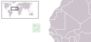
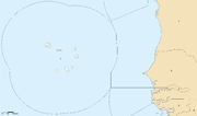
The Republic of Cape Verde is an island country, spanning an archipelago of 10 islands located in the central Atlantic Ocean, 570 kilometres off the coast of Western Africa...
is a group of arid Atlantic islands which are home to a number of birds and reptiles and constitute a unique ecoregion
Ecoregion
An ecoregion , sometimes called a bioregion, is an ecologically and geographically defined area that is smaller than an ecozone and larger than an ecosystem. Ecoregions cover relatively large areas of land or water, and contain characteristic, geographically distinct assemblages of natural...
in the World Wildlife Fund classification.
Location and description
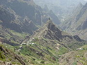
The Cape Verde Islands are located in the mid-Atlantic Ocean some 570 km (354 mi) off the west coast of Africa. The landscape varies from dry plains to high active volcanoes with cliffs rising steeply from the ocean. The climate is arid.The archipelago
Archipelago
An archipelago , sometimes called an island group, is a chain or cluster of islands. The word archipelago is derived from the Greek ἄρχι- – arkhi- and πέλαγος – pélagos through the Italian arcipelago...
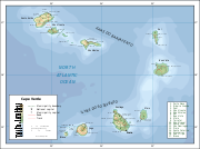
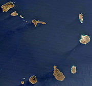
consists of 10 islands and 5 islets, divided into the windward (Barlavento) and leeward (Sotavento) groups. The six islands in the Barlavento group are Santo Antão, São Vicente
São Vicente, Cape Verde
São Vicente , also Son Visent or Son Sent in Cape Verdean Creole, is one of the Barlavento islands of Cape Verde. It is located between the islands of Santo Antão and Santa Luzia, with the Canal de São Vicente separating it from Santo Antão.- Geography :The island is roughly rectangular in shape...
, Santa Luzia
Santa Luzia, Cape Verde
Santa Luzia is an island of the Barlavento archipelago in Cape Verde located between São Nicolau and São Vicente. The area is 35 km² . The highest point is Monte Grande elevating 395 m...
, São Nicolau, Sal
Sal, Cape Verde
Sal is an island in Cape Verde. It belongs to the northern group of islands, called Barlavento. The island is composed by a single administrative division, the Sal municipality. The island is home to Amílcar Cabral International Airport, the main airport of Cape Verde.- Geography :The island is...
, and Boa Vista
Boa Vista, Cape Verde
Boa Vista is the easternmost island of Cape Verde. It is located in the Barlavento group of the archipelago. The island is known for marine turtles and traditional music, as well as its ultramarathon and its sand dunes and beaches...
. The islands in the Sotavento group are Maio
Maio, Cape Verde
Maio is the easternmost of the Sotavento islands of Cape Verde. Maio is located south of the islands of Boa Vista and east of Santiago. The island is also known for its large forest, which is unusual for Cape Verde.-Geography:The island covers an area of 269 km²...
, Santiago
Santiago, Cape Verde
Santiago , or Santiagu in Cape Verdean Creole, is the largest island of Cape Verde, its most important agricultural centre and home to half the nation’s population. At the time of Darwin's voyage it was called St. Jago....
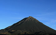
, Fogo
Fogo, Cape Verde
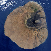
Fogo is an island in the Sotavento group of Cape Verde. It is the most prominent of the group, rising to nearly 3,000 m above sea level at Pico do Fogo.-Geography:...
, and Brava
Brava, Cape Verde
Brava is an island in Cape Verde. It is the smallest inhabited island, but at the same time the greenest, of Cape Verde, in the Sotavento group. First settled in the 1540s, its population grew after Mount Fogo on neighbouring Fogo erupted in 1675...
. All but Santa Luzia are inhabited.
Three islands – Sal, Boa Vista, and Maio – generally are level and lack natural water supplies. Mountains higher than 1280 metres (4,199 ft) are found on Santiago, Fogo, Santo Antão, and São Nicolau.
Sand carried by high winds has caused erosion on all islands, especially the windward ones. Sheer, jagged cliffs rise from the sea on several of the mountainous islands. The lack of natural vegetation in the uplands and coast also contributes to soil erosion. Only the interior valleys support natural vegetation.
Data
Geographic coordinates:- 16°N 24°W
Area:
- Total: 4,033 km²
- Land: 4,033 km²
- Water: 0 km²
Area – comparative:
- US: slightly larger than Rhode Island
- Canada: slightly larger than the Queen Charlotte Islands
- UK: slightly larger than Suffolk
Coastline:
- 965 km
Maritime claims:
- Measured from claimed archipelagic baselines
- Contiguous zone: 24 nmi (44.4 km)
- Exclusive economic zone: 200 nmi (370.4 km)
- Territorial sea: 12 nmi (22.2 km)
Exclusive economic zone
- EEZ area: 800,561 km²
- Continental shelf: 5,591 km²
- Coral Reefs: 0.09 % of world
- Sea Mounts: 0.04 % of world
Terrain:
- Steep, rugged, rocky, volcanic.
Elevation extremes:
- Lowest point: Atlantic Ocean 0 m
- Highest point: Mount FogoMount FogoPico do Fogo is the highest peak of Cape Verde, rising to above sea level. It is an active stratovolcano lying on the island of Fogo. The main cone last erupted in 1675, causing mass emigration from the island, while a subsidiary vent erupted in 1995...
2,829 m (a volcano on Fogo Island)
Natural resources:
- SaltSaltIn chemistry, salts are ionic compounds that result from the neutralization reaction of an acid and a base. They are composed of cations and anions so that the product is electrically neutral...
, basaltBasaltBasalt is a common extrusive volcanic rock. It is usually grey to black and fine-grained due to rapid cooling of lava at the surface of a planet. It may be porphyritic containing larger crystals in a fine matrix, or vesicular, or frothy scoria. Unweathered basalt is black or grey...
rock, limestoneLimestoneLimestone is a sedimentary rock composed largely of the minerals calcite and aragonite, which are different crystal forms of calcium carbonate . Many limestones are composed from skeletal fragments of marine organisms such as coral or foraminifera....
, kaolin, fishFishFish are a paraphyletic group of organisms that consist of all gill-bearing aquatic vertebrate animals that lack limbs with digits. Included in this definition are the living hagfish, lampreys, and cartilaginous and bony fish, as well as various extinct related groups...
. clayClayClay is a general term including many combinations of one or more clay minerals with traces of metal oxides and organic matter. Geologic clay deposits are mostly composed of phyllosilicate minerals containing variable amounts of water trapped in the mineral structure.- Formation :Clay minerals...
, gypsumGypsumGypsum is a very soft sulfate mineral composed of calcium sulfate dihydrate, with the chemical formula CaSO4·2H2O. It is found in alabaster, a decorative stone used in Ancient Egypt. It is the second softest mineral on the Mohs Hardness Scale...
Land use:
- Arable land: 11.41%
- Permanent crops: 0.74%
- Other: 87.85% (2005)
Irrigated land:
- 30 km² (2003)
Natural hazards:
- Prolonged droughtDroughtA drought is an extended period of months or years when a region notes a deficiency in its water supply. Generally, this occurs when a region receives consistently below average precipitation. It can have a substantial impact on the ecosystem and agriculture of the affected region...
s; harmattan wind produces obscuring dust; volcanically and seismically active.
Geography - note:
- Strategic location 500 km from west coast of Africa near major north-south sea routes; important communications station; important sea and air refueling site.
Borders
Maritime boundary
Maritime boundary is a conceptual means of division of the water surface of the planet into maritime areas that are defined through surrounding physical geography or by human geography. As such it usually includes areas of exclusive national rights over the mineral and biological resources,...
with Mauritania
Mauritania
Mauritania is a country in the Maghreb and West Africa. It is bordered by the Atlantic Ocean in the west, by Western Sahara in the north, by Algeria in the northeast, by Mali in the east and southeast, and by Senegal in the southwest...
and Senegal
Senegal
Senegal , officially the Republic of Senegal , is a country in western Africa. It owes its name to the Sénégal River that borders it to the east and north...
. Cape Verde has signed treaties
Treaty
A treaty is an express agreement under international law entered into by actors in international law, namely sovereign states and international organizations. A treaty may also be known as an agreement, protocol, covenant, convention or exchange of letters, among other terms...
with Senegal
Cape Verde – Senegal Maritime Delimitation Treaty
The Cape Verde – Senegal Maritime Delimitation Treaty is a treaty between Cape Verde and Senegal in which the two states agreed to the delimitation of their maritime boundary....
and Mauritania
Cape Verde – Mauritania Maritime Delimitation Treaty
The Cape Verde – Mauritania Maritime Delimitation Treaty is a treaty between Cape Verde and Mauritania in which the two states agreed to the delimitation of their maritime boundary....
delimiting
Boundary delimitation
Boundary delimitation, or simply delimitation, is the term used to describe the drawing of boundaries, but is most often used to describe the drawing of electoral boundaries, specifically those of precincts, states, counties or other municipalities...
the specific boundaries. However, the two treaties conflict in their delimitation of the precise borders.
Climate
See also: ClimateA cold Atlantic current produces an arid atmosphere around the archipelago. December–June is cool and dry, with temperatures at sea level averaging 21 °C (69.8 °F); July–November is warm and dry, with temperatures averaging 27 °C (80.6 °F). Although some rain comes during the latter season, rainfall is sparse overall and very erratic. Accumulations are generally around 130 mm (5.12 in) annually in the northern islands and 300 mm (11.81 in) in the south. The archipelago is subject to cyclical droughts; a devastating drought began in 1968 and was broken only briefly in 1975, 1978, 1984, and 1986.
Rainfall is irregular, historically causing periodic droughts and famines. The average precipitation per year in Praia
Praia
Praia , is the capital and largest city of Cape Verde, an island nation in the Atlantic Ocean west of Senegal. It lies on the southern coast of Santiago island in the Sotavento Islands group. It is the island's ferry port and is home to one of the nation’s four international airports...
is 240 mm (9.45 in). During the winter, storms blowing from the Sahara
Sahara
The Sahara is the world's second largest desert, after Antarctica. At over , it covers most of Northern Africa, making it almost as large as Europe or the United States. The Sahara stretches from the Red Sea, including parts of the Mediterranean coasts, to the outskirts of the Atlantic Ocean...
sometimes form dense dust clouds that obscure the sun; however, sunny days are the norm year round. The clearest skies are found between February and June, with very little rainfall during these months. Saharan dust, Harmattan wind, laden dust from the Sahara. This occurs between November and March and is generally similar to the "Calima" affecting the Canary Islands.
The ocean near Cape Verde is an area of tropical cyclone
Tropical cyclone
A tropical cyclone is a storm system characterized by a large low-pressure center and numerous thunderstorms that produce strong winds and heavy rain. Tropical cyclones strengthen when water evaporated from the ocean is released as the saturated air rises, resulting in condensation of water vapor...
formation; since these storms have the whole Atlantic over which to develop as they move westward, they are among the most intense hurricanes, and are called Cape Verde-type hurricane
Cape Verde-type hurricane
A Cape Verde-type hurricane is an Atlantic hurricane that develops near the Cape Verde islands, off the west coast of Africa. The average hurricane season has about two Cape Verde-type hurricanes, which are usually the largest and most intense storms of the season because they often have plenty of...
s.
The Cape Verde islands are a very degradated area. Also, most islands do not always get a monsoon. In fact, it is not surprising that some atmospheric precipitation of islands are limited in tropical rain.
If rain arrives, it is usually between August and October. The first "rainy season" brings high temperatures and high humidity that condenses as dew mountain. The other rainy season is between December and June, when the northeast trade winds are common during this season, only altitudes above 600m tend to receive regular rain.
The island of Sal receives an average of 0.0mm in May, When the rain come, if it comes, can be very strong. The half of the rain in a year can often fall into a single storm.
Due to its proximity to the Sahara, most of the Cape Verde islands are dry, but on islands with high mountains and farther away from the coast, by orography, the humidity is much higher, giving a rainforest habitat, very degraded by the strong human presence.
Northeastern slopes of high mountains often receive a lot of rain and Southwest slopes not. This is because they are Umbria areas, situated in the north hillsides or slopes of the mountainous areas, oriented behind the sun in the northern hemisphere
Northern Hemisphere
The Northern Hemisphere is the half of a planet that is north of its equator—the word hemisphere literally means “half sphere”. It is also that half of the celestial sphere north of the celestial equator...
, in the shadyside orographic
Orography
Orography is the study of the formation and relief of mountains, and can more broadly include hills, and any part of a region's elevated terrain...
. So the amount of solar radiation that it receive is much lower than it would if it had without the Island's relief which intercepts much of the sun. In terms of botanical ecology, these umbria areas are identified as being cool and moist.
The current north of the Canaries, has a cooling effect on the islands of Cape Verde, making the air temperature more bearable than it would expect in any case at this latitude. Conversely, the islands do not receive the upwellings (cold streams) that affect the West African coast, so the air temperature is cooler than in Senegal, but the sea is actually warmer, because the orographic relief of some islands, as Sao Miguel with steep mountains, cover it with rich woods and luxuriant vegetation where the dense moisture
Moisture
Humidity is the amount of moisture the air can hold before it rains. Moisture refers to the presence of a liquid, especially water, often in trace amounts...
condense and soak the plants, rocks, soil, logs, moss etc.
Hurricanes often begin their training in the waters around the islands of Cape Verde, but it is rare that the strength of the storm reaches close to the islands. A Cape Verde type Hurricane is formed in the area south of the islands, near Sao Miguel, after a tropical wave on the African continent during the rainy season. The storm picks up strength when it crosses the warm waters of Atlantic.
The laurel forest
Laurel forest
Laurel forest is a subtropical or mild temperate forest, found in areas with high humidity and relatively stable and mild temperatures. They are characterized by tree species with evergreen, glossy, enlongated leaves, known as laurophyll or lauroide...
is a type of cloud forest, the cloud forests
Cloud forest
A cloud forest, also called a fog forest, is a generally tropical or subtropical evergreen montane moist forest characterized by a persistent, frequent or seasonal low-level cloud cover, usually at the canopy level. Cloud forests often exhibit an abundance of mosses covering the ground and...
, are developed preferably about mountain
Mountain
Image:Himalaya_annotated.jpg|thumb|right|The Himalayan mountain range with Mount Everestrect 58 14 160 49 Chomo Lonzorect 200 28 335 52 Makalurect 378 24 566 45 Mount Everestrect 188 581 920 656 Tibetan Plateaurect 250 406 340 427 Rong River...
s, where the dense moisture
Moisture
Humidity is the amount of moisture the air can hold before it rains. Moisture refers to the presence of a liquid, especially water, often in trace amounts...
from the sea or ocean, is precipitated by the action of the relief. Opposing the terrain to a front of warm, moist air mass, it forces to increase the height above sea level of that body wet and warm air mass, which cools and decreases the dew point
Dew point
The dew point is the temperature to which a given parcel of humid air must be cooled, at constant barometric pressure, for water vapor to condense into liquid water. The condensed water is called dew when it forms on a solid surface. The dew point is a saturation temperature.The dew point is...
, causing it to condense part of the moisture that falls as rain or fog, creating an habitat especially cool, saturated with moisture in the air and soil.
It is the balance between the dry and warm influence of the subtropical anticyclone, hot and dry summer and orography
Orography
Orography is the study of the formation and relief of mountains, and can more broadly include hills, and any part of a region's elevated terrain...
the responsible for carrying cool wet.
As latitude increases, this increases the impact of the storms, which in its journey from west to east, swept the western coasts of continents, dumping heavy rains as carrying high humidity.
Precipitation multiply if these air masses are crossing mountains in the way. The resulting climate is wetter, but with an annual oscillation of the temperature moderated by the proximity of the ocean.
Appear mostly occupying favorable areas named geographically Umbria
Umbria
Umbria is a region of modern central Italy. It is one of the smallest Italian regions and the only peninsular region that is landlocked.Its capital is Perugia.Assisi and Norcia are historical towns associated with St. Francis of Assisi, and St...
s, this is north hillsides or slopes of the mountainous areas that are oriented behind the sun, be cause the islands are in the northern hemisphere
Northern Hemisphere
The Northern Hemisphere is the half of a planet that is north of its equator—the word hemisphere literally means “half sphere”. It is also that half of the celestial sphere north of the celestial equator...
, between 600 and 1500 meters, thus benefiting from the humidity provided by the trade winds to form such a sea of clouds. In its botanical ecology, the mountain umbria is identified with cool and moisture.
Flora
Cape Verde is the driest archipelago of the ecoregion of MacaronesiaMacaronesia
Macaronesia is a modern collective name for several groups of islands in the North Atlantic Ocean near Europe and North Africa belonging to three countries: Portugal, Spain, and Cape Verde...
. That with a greater influence of African species due to its geographical location near the african mainland of the Sahel.
At first, the islands of Cape Verde housed an extensive savanna and dry forest cover, but mostly it was removed to convert to agricultural land, which, together with the arid climate and rugged terrain, has led to a soil erosion and desertification widespread. However, the archipelago can be divided into four broad ecological zones (arid, semiarid, subhumid and humid), according to altitude and average annual rainfall ranging from 200 mm in the arid areas of the coast to more than 1 000 mm in the humid mountain. Mostly rainfall precipitation is due to condensation of the ocean mist. Today much of the forest cover comprises relatively immature agroforestry plantations, in which are used non-native species such as Prosopis juliflora, Leucaena leucocephala and Jatropha curcas. The native laurel forest
Laurel forest
Laurel forest is a subtropical or mild temperate forest, found in areas with high humidity and relatively stable and mild temperatures. They are characterized by tree species with evergreen, glossy, enlongated leaves, known as laurophyll or lauroide...
species are in wet area only in mountainous areas.
On the lower and drier islands the vegetation before human colonization consisted of savanna or steppe vegetation, with the flattest inland portion supporting semi-desert plants. At higher altitudes, a form of arid shrubland was also present. Once this islands were covered with savanna on the plains and arid shrubland on the mountainsides, but over 500 years of human habtitation, since colonisation by the Portuguese in the 15th century, nearly all the original vegetation has been cleared by widespread agriculture including the grazing of goats, sheep and cattle and the planting of imported crop species. There are some remaining patches of dry forest high on steep mountainside including a number of endemic plant species, but these are inaccessible and hard to study.
On the higher islands and somewhat wetter islands, exclusively in mountainous areas, like Santo Antao island, the climate is suitable for the development of dry monsoon forest, and laurel forest
Laurel forest
Laurel forest is a subtropical or mild temperate forest, found in areas with high humidity and relatively stable and mild temperatures. They are characterized by tree species with evergreen, glossy, enlongated leaves, known as laurophyll or lauroide...
as this vegetation is believed to have been present in the past. However, most vegetation has now been converted to agriculture and forest fragments are now restricted to areas where cultivation is not possible, such as mountain peaks and steep slopes. The demand for wood has resulted in deforestation and desertification.
Of particular note is the endemic
Endemic (ecology)
Endemism is the ecological state of being unique to a defined geographic location, such as an island, nation or other defined zone, or habitat type; organisms that are indigenous to a place are not endemic to it if they are also found elsewhere. For example, all species of lemur are endemic to the...
type of humid subtropical laurel forest
Laurel forest
Laurel forest is a subtropical or mild temperate forest, found in areas with high humidity and relatively stable and mild temperatures. They are characterized by tree species with evergreen, glossy, enlongated leaves, known as laurophyll or lauroide...
of macaronesian laurisilva, found on several of the Macaronesia
Macaronesia
Macaronesia is a modern collective name for several groups of islands in the North Atlantic Ocean near Europe and North Africa belonging to three countries: Portugal, Spain, and Cape Verde...
n islands of the North Atlantic and Macaronesian African mainland enclaves, namely Madeira Islands, the Azores
Azores
The Archipelago of the Azores is composed of nine volcanic islands situated in the middle of the North Atlantic Ocean, and is located about west from Lisbon and about east from the east coast of North America. The islands, and their economic exclusion zone, form the Autonomous Region of the...
, Cape Verde Islands and the Canary Islands
Canary Islands
The Canary Islands , also known as the Canaries , is a Spanish archipelago located just off the northwest coast of mainland Africa, 100 km west of the border between Morocco and the Western Sahara. The Canaries are a Spanish autonomous community and an outermost region of the European Union...
, a relict
Relict
A relict is a surviving remnant of a natural phenomenon.* In biology a relict is an organism that at an earlier time was abundant in a large area but now occurs at only one or a few small areas....
of the Pliocene
Pliocene
The Pliocene Epoch is the period in the geologic timescale that extends from 5.332 million to 2.588 million years before present. It is the second and youngest epoch of the Neogene Period in the Cenozoic Era. The Pliocene follows the Miocene Epoch and is followed by the Pleistocene Epoch...
subtropical forest
Forest
A forest, also referred to as a wood or the woods, is an area with a high density of trees. As with cities, depending where you are in the world, what is considered a forest may vary significantly in size and have various classification according to how and what of the forest is composed...
s, supporting numerous endemic species.
This laurisilva
Laurisilva
Laurisilva or laurissilva is a subtropical forest, found in areas with high humidity and relatively stable and mild temperatures. They are characterised by evergreen, glossy-leaved tree species that look alike with leaves of lauroide type...
forests are found in the islands of Macaronesia
Macaronesia
Macaronesia is a modern collective name for several groups of islands in the North Atlantic Ocean near Europe and North Africa belonging to three countries: Portugal, Spain, and Cape Verde...
in the eastern Atlantic, in particular the Azores
Azores
The Archipelago of the Azores is composed of nine volcanic islands situated in the middle of the North Atlantic Ocean, and is located about west from Lisbon and about east from the east coast of North America. The islands, and their economic exclusion zone, form the Autonomous Region of the...
, Madeira Islands, and western Canary Islands
Canary Islands
The Canary Islands , also known as the Canaries , is a Spanish archipelago located just off the northwest coast of mainland Africa, 100 km west of the border between Morocco and the Western Sahara. The Canaries are a Spanish autonomous community and an outermost region of the European Union...
, from 400 m to 1200 m elevation. Trees of the genera Apollonias
Apollonias
Apollonias is a genus of flowering plants belonging to the laurel family, Lauraceae. The genus includes from one to ten species of evergreen trees and shrubs from laurel forest habitat mainly in Macaronesian islands.-Description:...
(Lauraceae
Lauraceae
The Lauraceae or Laurel family comprises a group of flowering plants included in the order Laurales. The family contains about 55 genera and over 3500, perhaps as many as 4000, species world-wide, mostly from warm or tropical regions, especially Southeast Asia and South America...
), Ocotea
Ocotea
Ocotea is a genus of flowering plants belonging to the family Lauraceae. The genus includes over 200 species of evergreen trees and shrubs, distributed mostly in tropical and subtropical regions of Central and South America, the West Indies, also with a few species in Africa and Madagascar, and...
(Lauraceae), Persea
Persea
Persea is a genus of about 150 species of evergreen trees belonging to the laurel family, Lauraceae. The best-known member of the genus is the avocado, P. americana, widely cultivated in subtropical regions for its large, edible fruit.-Overview:...
(Lauraceae), Clethra
Clethra
Clethra is a genus of between 30-70 species of flowering shrubs or small trees. It is one of two genera in the family Clethraceae...
(Clethraceae), Dracaena
Dracaena (plant)
Dracaena is a genus of about 40 species of trees and succulent shrubs. In the APG III classification system, it is placed in the family Asparagaceae, subfamily Nolinoideae . It has also formerly been separated into the family Dracaenaceae or placed in the Agavaceae...
(Ruscaceae
Ruscaceae
Nolinoideae is a monocot subfamily of the family Asparagaceae in the APG III system of 2009. It was previously treated as a separate family, Ruscaceae s.l...
), and Picconia
Picconia
Picconia is a genus of flowering plants in the family Oleaceae.-Species:*Picconia azorica - endemic to the archipelago of the Azores*Picconia excelsa - tree up to 15m; Madeira, Canaries...
(Oleaceae
Oleaceae
Oleaceae are a family containing 24 extant genera and around 600 species of mesophytic shrubs, trees and occasionally vines. As shrubs, members of this family may be twine climbers, or scramblers.-Leaves:...
) are characteristic. The Madeira Islands laurel forest was designated a World Heritage Site
World Heritage Site
A UNESCO World Heritage Site is a place that is listed by the UNESCO as of special cultural or physical significance...
by UNESCO
UNESCO
The United Nations Educational, Scientific and Cultural Organization is a specialized agency of the United Nations...
in 1999.
Fauna
There are four endemic bird species including the Raso LarkRaso Lark
The Raso Lark is a small passerine bird with a highly restricted range, being found only on Raso islet in the Cape Verde Islands...
along with more common swifts, larks, warblers, and sparrows. The islands are an important breeding site for seabirds including the Cape Verde Shearwater
Cape Verde Shearwater
The Cape Verde Shearwater , or Cagarra locally, is a medium-large shearwater, a seabird in the petrel family Procellariidae. It is a breeding endemic of the Cape Verde archipelago of Macaronesia in the Atlantic Ocean, off the coast of West Africa.-Taxonomy:The Cape Verde Shearwater was originally...
and Fea's Petrel
Fea's Petrel
Fea's Petrel is a small seabird in the gadfly petrel genus, Pterodroma. It was previously considered to be a subspecies of the Soft-plumaged Petrel, P. mollis, but they are actually not closely related at all. However, P. feae is very closely related to Zino's Petrel and Deserta's Petrel, two...
(Pterodroma feae), which breeds only here and in Madeira
Madeira
Madeira is a Portuguese archipelago that lies between and , just under 400 km north of Tenerife, Canary Islands, in the north Atlantic Ocean and an outermost region of the European Union...
. Santiago Island holds the only breeding site of the endemic and critically endangered Bourne's Heron
Bourne's Heron
Bourne's Heron , also known as the Cape Verde Heron, Cape Verde Purple Heron or Santiago Heron, or locally in Portuguese as the garça vermelha, is an endangered subspecies of the Purple Heron that is endemic to the Cape Verde archipelago, in the Atlantic Ocean off the coast of West Africa...
. The 11 endemic reptile species include a giant gecko (Tarentola
Tarentola
Tarentola is a genus of geckos, commonly known as Wall Geckos.-Classification of genus Tarentola:*Jamaican Giant Gecko, Tarentola albertschwartzi *American Wall Gecko, Tarentola americana...
gigas), and there are other gecko
Gecko
Geckos are lizards belonging to the infraorder Gekkota, found in warm climates throughout the world. They range from 1.6 cm to 60 cm....
s and skink
Skink
Skinks are lizards belonging to the family Scincidae. Together with several other lizard families, including Lacertidae , they comprise the superfamily or infraorder Scincomorpha...
s in abundance. The giant skink (Macroscincus coctei) is now thought to be extinct.
Threats and protection
Almost all of the natural environment has been destroyed by conversion to agriculture and logging for firewood, as well as natural soil erosion, all of which has threatened several species of birds and reptiles. The remaining original forest exists at high altitudes only. Newer problems include illegal beach sand extraction and overfishingOverfishing
Overfishing occurs when fishing activities reduce fish stocks below an acceptable level. This can occur in any body of water from a pond to the oceans....
while the nesting birds are vulnerable to introduced mammals including cats and rats.
Environment - international agreements:
- Party to: BiodiversityBiodiversityBiodiversity is the degree of variation of life forms within a given ecosystem, biome, or an entire planet. Biodiversity is a measure of the health of ecosystems. Biodiversity is in part a function of climate. In terrestrial habitats, tropical regions are typically rich whereas polar regions...
, Climate ChangeUnited Nations Framework Convention on Climate ChangeThe United Nations Framework Convention on Climate Change is an international environmental treaty produced at the United Nations Conference on Environment and Development , informally known as the Earth Summit, held in Rio de Janeiro from June 3 to 14, 1992...
, DesertificationDesertificationDesertification is the degradation of land in drylands. Caused by a variety of factors, such as climate change and human activities, desertification is one of the most significant global environmental problems.-Definitions:...
, Environmental Modification, Hazardous Wastes, Law of the SeaLaw of the seaLaw of the sea may refer to:* United Nations Convention on the Law of the Sea* Admiralty law* The Custom of the Sea...
, Marine Dumping, Nuclear Test Ban - Signed, but not ratified: None of the selected agreements
Visiting the ecoregion
The higher altitudes of the islands are accessible on the islands of FogoFogo, Cape Verde
Fogo is an island in the Sotavento group of Cape Verde. It is the most prominent of the group, rising to nearly 3,000 m above sea level at Pico do Fogo.-Geography:...
, where there is a road to the volcano and walks up to the crater, and the mountainous Santo Antão where there are hiking routes.
Extreme points
- Northernmost Point - Ponta do SolPonta do Sol, Cape VerdePonta do Sol is a small fishing settlement situated in the northern part of the island municipality of Santo Antão, Cape Verde. The city is the 12th largest in Cape Verde and is the seat of Ribeira Grande municipality...
on Santao Antão Island - Southernmost point - Ponta Nho Martinho on BravaBrava, Cape VerdeBrava is an island in Cape Verde. It is the smallest inhabited island, but at the same time the greenest, of Cape Verde, in the Sotavento group. First settled in the 1540s, its population grew after Mount Fogo on neighbouring Fogo erupted in 1675...
- Westernmost point - Ponta Chao de Mongrade on Santao Antão*
- Easternmost point - a cape about 5 km ESE of Tarales on Boa VistaBoa Vista, Cape VerdeBoa Vista is the easternmost island of Cape Verde. It is located in the Barlavento group of the archipelago. The island is known for marine turtles and traditional music, as well as its ultramarathon and its sand dunes and beaches...
island
- *Note: this is also the westernmost point of Africa