

Geography and climate of Toronto
Encyclopedia
Toronto
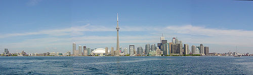
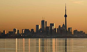
Toronto is the provincial capital of Ontario and the largest city in Canada. It is located in Southern Ontario on the northwestern shore of Lake Ontario. A relatively modern city, Toronto's history dates back to the late-18th century, when its land was first purchased by the British monarchy from...
, Canada
Canada
Canada is a North American country consisting of ten provinces and three territories. Located in the northern part of the continent, it extends from the Atlantic Ocean in the east to the Pacific Ocean in the west, and northward into the Arctic Ocean...
, covers an area of 630 km² (243 sq mi) and is bounded by Lake Ontario
Lake Ontario
Lake Ontario is one of the five Great Lakes of North America. It is bounded on the north and southwest by the Canadian province of Ontario, and on the south by the American state of New York. Ontario, Canada's most populous province, was named for the lake. In the Wyandot language, ontarío means...
to the south, Etobicoke Creek
Etobicoke Creek
Etobicoke Creek is one of the many creeks running through Toronto, Ontario and the Toronto Area into Lake Ontario, often characterized by their winding paths through deep ravines and distinctive shale banks....
and Highway 427 to the west, Steeles Avenue
Steeles Avenue
Steeles Avenue is an east-west street that forms the northern city limit of Toronto and the southern limit of York Region, Ontario, Canada. It stretches across the western Greater Toronto Area from Milborough Townline in Halton Region east to the Scarborough-Pickering limit. It runs for within...
to the north, and the Rouge River
Rouge River (Ontario)
The Rouge River is a two river system. Little Rouge and Rouge River are in the east and the northeast parts of Toronto and begin in the Oak Ridges Moraine in Richmond Hill and Whitchurch-Stouffville...
to the east. In addition to Etobicoke Creek and the Rouge River, the city is trisected by two minor rivers and their tributaries, the Humber River
Humber River (Ontario)
The Humber River is one of two major rivers on either side of Toronto, Ontario, Canada, the other being the Don River to the east. It was designated a Canadian Heritage River on September 24, 1999....
in the west end and the Don River east of downtown. Both flow southward to Lake Ontario at Humber Bay and Toronto Harbour
Toronto Harbour
Toronto Harbour or Toronto Bay is a bay on the north shore of Lake Ontario, in Toronto, Ontario, Canada. It is a natural harbour, protected from Lake Ontario waves by the Toronto Islands. It is a commercial port on the Great Lakes as well as a recreational harbour...
respectively, which are part of the longer Waterfront
Toronto waterfront
The Toronto waterfront is the lakeshore of Lake Ontario in the City of Toronto, Ontario in Canada. It spans 46 kilometres between the mouth of Etobicoke Creek in the west, and the Rouge River in the East. The entire lakeshore has been significantly altered from its natural glaciated state prior to...
.
The concentration and protection of Toronto's ravines
Toronto ravine system
The Toronto ravine system is one of the most distinctive features of the geography of Toronto, Ontario, Canada. It is a network of deep ravines that form a large urban forest that runs throughout much of the city...
allows for large tracts of densely forested valleys with recreational trails within the city. 17.5% of Toronto is covered with trees, a fairly high percentage within a large city in North America and there are ambitious proposals to double the coverage.
Glacial Lake Iroquois
Glacial Lake Iroquois was a prehistoric proglacial lake that existed at the end of the last ice age approximately 13,000 years ago.The lake was essentially an enlargement of the present Lake Ontario that formed because the St. Lawrence River downstream from the lake was blocked by the ice sheet...
is a major west−east geological feature which was formed at the end of the last glacial period. In the west end, Davenport Road follows the ancient shoreline with the steps to Casa Loma
Casa Loma
Casa Loma is a Gothic Revival style house in midtown Toronto, Ontario, Canada, that is now a museum and landmark. It was originally a residence for financier Sir Henry Mill Pellatt. Casa Loma was constructed over a three-year period from 1911–1914. The architect of the mansion was E. J...
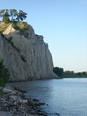
rising above and downtown skyscrapers clearly visible to the southeast. It merges with current Lake Ontario shoreline at the Scarborough Bluffs
Scarborough Bluffs
The Scarborough Bluffs is an escarpment in Scarborough, Toronto, Ontario, Canada. Forming much of the eastern portion of Toronto's waterfront, it is located along the shoreline of Lake Ontario. At its highest point, the escarpment rises above its foot and spans a length of...
promontory.
Toronto's immediate neighbours are Mississauga and Brampton
Brampton
Brampton is the third-largest city in the Greater Toronto Area of Ontario, Canada.Brampton may also refer to:- Canada :* Brampton, a city in Ontario** Brampton GO Station, a station in the GO Transit network located in the city- United Kingdom :...
within the Regional Municipality of Peel, Vaughan
Vaughan
Vaughan is a city in York Region north of Toronto, Ontario, Canada. Vaughan is the fastest growing municipality in Canada achieving a population growth rate of 80.2% between 1996–2006, according to Statistics Canada having nearly doubled in population since 1991. Vaughan is located in Southern...
and Markham
Markham, Ontario
Markham is a town in the Regional Municipality of York, located within the Greater Toronto Area of Southern Ontario, Canada. The population was 261,573 at the 2006 Canadian census...
within the Regional Municipality of York, and Pickering
Pickering, Ontario
Pickering is a city located in Southern Ontario, Canada immediately east of Toronto in Durham Region. It is part of the Greater Toronto Area, the largest metropolitan area in Canada.- Early Period :...
within the Regional Municipality of Durham. The Greater Toronto Area
Greater Toronto Area
The Greater Toronto Area is the largest metropolitan area in Canada, with a 2006 census population of 5.5 million. The Greater Toronto Area is usually defined as the central city of Toronto, along with four regional municipalities surrounding it: Durham, Halton, Peel, and York...
(GTA) includes the regional municipalities
Regional municipality
A regional municipality is a type of Canadian municipal government similar to and at the same municipal government level as a county, although the specific structure and servicing responsibilities may vary from place to place...
of Halton, Peel, York and Durham.
The GTA is part of a larger, natural ecosystem
Ecosystem
An ecosystem is a biological environment consisting of all the organisms living in a particular area, as well as all the nonliving , physical components of the environment with which the organisms interact, such as air, soil, water and sunlight....
known as the Greater Toronto Bioregion
Greater Toronto Bioregion
The Greater Toronto Bioregion represents a unique ecosystem that co-exists with the urban sprawl of the Greater Toronto Area. It is also part of the Oak Ridges Moraine system....
. This ecosystem is bounded by Lake Ontario, the Niagara Escarpment
Niagara Escarpment
The Niagara Escarpment is a long escarpment, or cuesta, in the United States and Canada that runs westward from New York State, through Ontario, Michigan, Wisconsin and Illinois...
, and the Oak Ridges Moraine
Oak Ridges Moraine
The Oak Ridges Moraine is an ecologically important geological landform in the Mixedwood Plains of south-central Ontario, Canada. The moraine covers a geographic area of between Caledon and Rice Lake, near Peterborough...
, and includes many watersheds
Drainage basin
A drainage basin is an extent or an area of land where surface water from rain and melting snow or ice converges to a single point, usually the exit of the basin, where the waters join another waterbody, such as a river, lake, reservoir, estuary, wetland, sea, or ocean...
that drain into Lake Ontario. Some parts of Toronto, such as High Park
High Park
High Park is a municipal park in Toronto, Ontario, Canada. It spans , and is a mixed recreational and natural park, with sporting facilities, cultural facilities, educational facilities, gardens, playgrounds and a zoo. One third of the park remains in a natural state, with a rare oak savannah ecology...
and the lower Humber River are located in the most northern parts of the Carolinian forest
Carolinian forest
The Carolinian forest is a life zone in eastern North America characterized primarily by a predominance of deciduous, or broad-leaf trees. The term "Carolinian forest" is used primarily in Canada...
zone found in North America.
In March 2005, the Government of Ontario
Government of Ontario
The Government of Ontario refers to the provincial government of the province of Ontario, Canada. Its powers and structure are set out in the Constitution Act, 1867....
unveiled the boundaries of a greenbelt around the Greater Toronto Area
Greenbelt (Golden Horseshoe)
The Greenbelt is a permanently protected area of green space, farmland, forests, wetlands, and watersheds, located in Southern Ontario, Canada. It surrounds a significant portion of Canada's most populated and fastest-growing area - The Golden Horseshoe....
, a 7200 km² (2,779.9 sq mi) area stretching from Niagara Falls
Niagara Falls, Ontario
Niagara Falls is a Canadian city on the Niagara River in the Golden Horseshoe region of Southern Ontario. The municipality was incorporated on June 12, 1903...
to Peterborough
Peterborough, Ontario
Peterborough is a city on the Otonabee River in southern Ontario, Canada, 125 kilometres northeast of Toronto. The population of the City of Peterborough was 74,898 as of the 2006 census, while the census metropolitan area has a population of 121,428 as of a 2009 estimate. It presently ranks...
. The green belt
Green belt
A green belt or greenbelt is a policy and land use designation used in land use planning to retain areas of largely undeveloped, wild, or agricultural land surrounding or neighbouring urban areas. Similar concepts are greenways or green wedges which have a linear character and may run through an...
is designed to curb urban sprawl
Urban sprawl
Urban sprawl, also known as suburban sprawl, is a multifaceted concept, which includes the spreading outwards of a city and its suburbs to its outskirts to low-density and auto-dependent development on rural land, high segregation of uses Urban sprawl, also known as suburban sprawl, is a...
and to preserve valuable natural areas and farmland
Arable land
In geography and agriculture, arable land is land that can be used for growing crops. It includes all land under temporary crops , temporary meadows for mowing or pasture, land under market and kitchen gardens and land temporarily fallow...
surrounding the city. Toronto is the latest in a line of cities that have implemented growth boundaries
Urban growth boundary
An urban growth boundary, or UGB, is a regional boundary, set in an attempt to control urban sprawl by mandating that the area inside the boundary be used for higher density urban development and the area outside be used for lower density development.An urban growth boundary circumscribes an...
of some kind as a method of restricting urban growth, including Ottawa
Ottawa
Ottawa is the capital of Canada, the second largest city in the Province of Ontario, and the fourth largest city in the country. The city is located on the south bank of the Ottawa River in the eastern portion of Southern Ontario...
, Portland
Portland, Oregon
Portland is a city located in the Pacific Northwest, near the confluence of the Willamette and Columbia rivers in the U.S. state of Oregon. As of the 2010 Census, it had a population of 583,776, making it the 29th most populous city in the United States...
, Oregon, Frankfurt, Melbourne
Melbourne
Melbourne is the capital and most populous city in the state of Victoria, and the second most populous city in Australia. The Melbourne City Centre is the hub of the greater metropolitan area and the Census statistical division—of which "Melbourne" is the common name. As of June 2009, the greater...
, Seoul
Seoul
Seoul , officially the Seoul Special City, is the capital and largest metropolis of South Korea. A megacity with a population of over 10 million, it is the largest city proper in the OECD developed world...
and London, UK
London
London is the capital city of :England and the :United Kingdom, the largest metropolitan area in the United Kingdom, and the largest urban zone in the European Union by most measures. Located on the River Thames, London has been a major settlement for two millennia, its history going back to its...
.
Climate
Toronto's continental climateContinental climate
Continental climate is a climate characterized by important annual variation in temperature due to the lack of significant bodies of water nearby...
is moderated by Lake Ontario; its climate is among the mildest in Canada east of the Rocky Mountains
Rocky Mountains
The Rocky Mountains are a major mountain range in western North America. The Rocky Mountains stretch more than from the northernmost part of British Columbia, in western Canada, to New Mexico, in the southwestern United States...
. It sits in a pocket of the humid continental climate (Köppen climate classification
Köppen climate classification
The Köppen climate classification is one of the most widely used climate classification systems. It was first published by Crimea German climatologist Wladimir Köppen in 1884, with several later modifications by Köppen himself, notably in 1918 and 1936...
Dfa) climate zone found at the south-western end of Lake Ontario covering the southern part of the city - including downtown, where the annual average temperature exceeds 9 °C (48 °F). There is a high degree of variability from year to year and sometimes even over a period of days, particularly during the winter
Winter
Winter is the coldest season of the year in temperate climates, between autumn and spring. At the winter solstice, the days are shortest and the nights are longest, with days lengthening as the season progresses after the solstice.-Meteorology:...
months.
Lake Ontario's water temperature varies due to upwelling
Upwelling
Upwelling is an oceanographic phenomenon that involves wind-driven motion of dense, cooler, and usually nutrient-rich water towards the ocean surface, replacing the warmer, usually nutrient-depleted surface water. The increased availability in upwelling regions results in high levels of primary...
of colder water or warmer pools of surface water
Surface water
Surface water is water collecting on the ground or in a stream, river, lake, wetland, or ocean; it is related to water collecting as groundwater or atmospheric water....
creating very localized thermal contrast; the deeper waters of the lake remain at a near constant water temperature of 4 °C (39 °F), the effect of which is either cooling or warming (in winter). This creates generally warmer nights through the colder season. When offshore winds occur in summer, they warm as they blow toward the lakeshore in the evening; conversely, the cooling effect by the lake is most pronounced on spring
Spring (season)
Spring is one of the four temperate seasons, the transition period between winter and summer. Spring and "springtime" refer to the season, and broadly to ideas of rebirth, renewal and regrowth. The specific definition of the exact timing of "spring" varies according to local climate, cultures and...
afternoons, which affects Toronto even more than other cities on the Great Lakes as during spring onshore east to southeast winds are predominant, on some days the temperatures can be as much as 10C cooler than areas south of Lake Ontario away from its influence, an effect that wanes by summer when the dominant windflow becomes more southwesterly.
Springs and autumn
Autumn
Autumn is one of the four temperate seasons. Autumn marks the transition from summer into winter usually in September or March when the arrival of night becomes noticeably earlier....
s feature varied weather with alternating periods of dry, sunny weather and rain. These seasons are brief when compared to summer or winter seasons, many days are sunny with pleasant temperatures. Nights are generally cool, but frosts are rare. Snow can fall in early spring or late fall but usually melts quickly after contact with the ground. At these times of year, great temperature contrasts (up to 30 C-change) can occur within a short time frame due to rapidly changing air masses that sweep across the continent.
Annual average precipitation
Precipitation (meteorology)
In meteorology, precipitation In meteorology, precipitation In meteorology, precipitation (also known as one of the classes of hydrometeors, which are atmospheric water phenomena is any product of the condensation of atmospheric water vapor that falls under gravity. The main forms of precipitation...
is 834 mm (32.83 in).
Winter and snowfall
Despite being cold, extended snow free periods occur in most winters. The average January maximum/minimum is −1 C/−7 C in the city. There are usually a few colder periods where temperatures remain below −10 C and less frequently below −20 C (especially in the northern suburbs), with wind chillWind chill
Wind chill is the felt air temperature on exposed skin due to wind. The wind chill temperature is always lower than the air temperature, and the windchill is undefined at the higher temps...
s making it feel like −30 ºC (−22 ºF).
Due to its position on the northwest shore of Lake Ontario, Toronto is not a direct target of heavy, wind−whipped lake-effect snow squall
Squall
A squall is a sudden, sharp increase in wind speed which is usually associated with active weather, such as rain showers, thunderstorms, or heavy snow. Squalls refer to an increase in the sustained winds over a short time interval, as there may be higher gusts during a squall event...
s that hit other Great Lake
Great Lakes
The Great Lakes are a collection of freshwater lakes located in northeastern North America, on the Canada – United States border. Consisting of Lakes Superior, Michigan, Huron, Erie, and Ontario, they form the largest group of freshwater lakes on Earth by total surface, coming in second by volume...
cities on the south/east shorelines of the lakes, in areas where prevailing winds amplify lake effect. Despite this, there are usually two or more heavy snowfalls each winter which deposit at least 15 cm (5.91 in) accumulation, usually from powerful winter storm
Winter storm
A winter storm is an event in which the dominant varieties of precipitation are formed that only occur at low temperatures, such as snow or sleet, or a rainstorm where ground temperatures are low enough to allow ice to form...
s known as "Colorado Low"s or Panhandle Hook
Panhandle hook
A Panhandle hook is a relatively infrequent storm system whose cyclogenesis occurs in the South to southwestern United States from the late fall through winter and into the early spring months...
s. These storms can produce strong easterly driven winds that fetch additional moisture
Moisture
Humidity is the amount of moisture the air can hold before it rains. Moisture refers to the presence of a liquid, especially water, often in trace amounts...
from Lake Ontario. They frequently come with a volatile mix of snow, ice pellets
Ice pellets
Ice pellets are a form of precipitation consisting of small, translucent balls of ice. Ice pellets usually are smaller than hailstones. They often bounce when they hit the ground, and generally do not freeze into a solid mass unless mixed with freezing rain...
, freezing rain
Freezing rain
Freezing rain is the name given to rain that falls when surface temperatures are below freezing. The raindrops become supercooled while passing through a sub-freezing layer of air, many hundred feet , just above the surface, and then freeze upon impact with any object they encounter. The resulting...
and ordinary rain, all of which can disrupt transportation, and in severe cases, power supply in the area. Lighter, drier snows generally originate from Alberta clipper
Alberta clipper
An Alberta clipper is a fast moving low pressure area which generally affects the central provinces of Canada and parts of the Upper Midwest and Great Lakes regions of the United States. Most clippers occur between December and February, but can also occur occasionally in the month of November...
s. Average winter snowfall is 133.1 cm (52.4 in) at the weather station in Downtown Toronto
Downtown Toronto
Downtown Toronto is the central business district of Toronto, Ontario, Canada. It is approximately bounded by Bloor Street to the north, Lake Ontario to the south, the Don River to the east, and Bathurst Street to the west...
and 115.4 cm (45.43 in) at the airport.
Exceptional winter weather can create havoc. On January 13, 1999, former Toronto mayor Mel Lastman
Mel Lastman
Melvin Douglas "Mel" Lastman , nicknamed "Mayor Mel", is a former businessman and politician. He is the founder of the Bad Boy Furniture chain. He served as the mayor of the former city of North York, Ontario, Canada from 1972 until 1997. At the end of 1997, North York, along with five other...
called in the Canadian Forces
Canadian Forces
The Canadian Forces , officially the Canadian Armed Forces , are the unified armed forces of Canada, as constituted by the National Defence Act, which states: "The Canadian Forces are the armed forces of Her Majesty raised by Canada and consist of one Service called the Canadian Armed Forces."...
to assist with snow removal and clearing streets. Within twelve days, the downtown Toronto weather station at the University of Toronto
University of Toronto
The University of Toronto is a public research university in Toronto, Ontario, Canada, situated on the grounds that surround Queen's Park. It was founded by royal charter in 1827 as King's College, the first institution of higher learning in Upper Canada...
(Trinity College
University of Trinity College
The University of Trinity College, informally referred to as Trin, is a college of the University of Toronto, founded in 1851 by Bishop John Strachan. Trinity was intended by Strachan as a college of strong Anglican alignment, after the University of Toronto severed its ties with the Church of...
near Queens Park) recorded an average season's worth of 118.4 cm (46.6 in) of snow, much of it lake effect from Lake Ontario and a monthly record for January, but fell short of the snowiest month overall (March 1870, with 158.5 cm (62.4 in)). February 2008 set a record a snowfall record for the month with 76.8 cm (30.2 in) falling at the airport. The winter of 2007−08 brought accumulated seasonal snowfall totals of 209.7 cm (82.6 in) downtown and 194 cm (76.4 in) at the airport, which did not break the all−time records but was the snowiest in recent memory: 313.7 cm (123.5 in) downtown (1869−70) and 206.7 cm (81.4 in) at the airport (1938−39) still hold as the snowiest winters (Note: climate records downtown date back to 1840 nearly 100 years earlier than the airport, which go back to 1937). The El Nino influenced winter of 2009-10 set records for the least snowfall with close to 50 cm (19.7 in) falling during the entire season, March 2010 recorded no measurable snow, the first such occurrence in any March since 1946. This was followed by the record warmest April.
Smog
Smog is a type of air pollution; the word "smog" is a portmanteau of smoke and fog. Modern smog is a type of air pollution derived from vehicular emission from internal combustion engines and industrial fumes that react in the atmosphere with sunlight to form secondary pollutants that also combine...
.
Thunderstorms are a regular occurrence and can pop up quickly, especially west and north of the city in areas more prone to the "lake breeze front" or "lake breeze thunderstorms" phenomenon, in which intense, sharply defined squall lines develop quickly on summer afternoons amplified by localized wind patterns between the Great Lakes. These storms sometimes move into the city causing localized flooding, intense lightning and severe winds knocking down trees and powerlines.Based on public records provided by Environment Canada, the average annual temperature has increased 1.3 C-change at Pearson Airport over the last decade as compared to the thirty−year normals from 1971−2000, more of this increase occurred at night: the average minimum temperature was 1.7 C-change higher last decade. By month, the largest mean temperature increases occurred in September, August, January, April and November while only a marginal average increase was observed for May. A good part of this warming can likely be attributed to increased urban growth surrounding the airport.
An older study conducted in the 1990s analyzed the heat island effect comparing data from selected regional stations, including both Downtown Toronto and Pearson Airport.
The table below is preliminary average temperature data for the last decade provided by Environment Canada's climate database. It might be noted that the decades between the 1920-1950s were somewhat warmer in Toronto than the period from the 1960s through to the first half of the 1990s, a large part of the latter timespan is included in the 1971-2000 climate averages.
Severe weather and records
Tropical stormsTropical cyclone
A tropical cyclone is a storm system characterized by a large low-pressure center and numerous thunderstorms that produce strong winds and heavy rain. Tropical cyclones strengthen when water evaporated from the ocean is released as the saturated air rises, resulting in condensation of water vapor...
, very severe thunderstorm
Thunderstorm
A thunderstorm, also known as an electrical storm, a lightning storm, thundershower or simply a storm is a form of weather characterized by the presence of lightning and its acoustic effect on the Earth's atmosphere known as thunder. The meteorologically assigned cloud type associated with the...
s or tornado
Tornado
A tornado is a violent, dangerous, rotating column of air that is in contact with both the surface of the earth and a cumulonimbus cloud or, in rare cases, the base of a cumulus cloud. They are often referred to as a twister or a cyclone, although the word cyclone is used in meteorology in a wider...
es are rare, but have occurred. Tornado warnings have been posted for the city on a few occasions in the past few years, however no touchdowns have been confirmed in the city since a weak tornado hit Scarborough
Scarborough, Ontario
Scarborough is a dissolved municipality within the city of Toronto, Ontario, Canada. Geographically, it comprises the eastern part of Toronto. It is bordered on the south by Lake Ontario, on the west by Victoria Park Avenue, on the north by Steeles Avenue East, and on the east by the Rouge River...
in the mid−1990s. A pair of dangerous F2
Fujita scale
The Fujita scale , or Fujita-Pearson scale, is a scale for rating tornado intensity, based primarily on the damage tornadoes inflict on human-built structures and vegetation...
tornados did touchdown in neighbouring Vaughan on August 20 during the 2009 tornado season
Southern Ontario Tornado Outbreak of 2009
The Southern Ontario Tornado Outbreak of 2009 was a series of severe thunderstorms that spawned numerous tornadoes in Southwestern Ontario, Central Ontario and the Greater Toronto Area on August 20, 2009, and was the largest single-day tornado outbreak in Ontario history and the largest in...
.
The tropical storm remnant of Hurricane Hazel
Hurricane Hazel
Hurricane Hazel was the deadliest and costliest hurricane of the 1954 Atlantic hurricane season. The storm killed as many as 1,000 people in Haiti before striking the United States near the border between North and South Carolina, as a Category 4 hurricane...
caused 81 deaths in October 1954 due to flooding that swept homes along river banks into Lake Ontario. A sudden downburst during a strong thunderstorm was believed to have played a contributing factor in the Air France Flight 358
Air France Flight 358
Air France Flight 358, a flight from Paris, France, to Toronto, Canada, using an Airbus A340 airliner, departed Paris without incident at 11:53 UTC 2 August 2005, later touching down on runway 24L-06R at Toronto Pearson International Airport at 20:01 UTC...
crash in August 2005 and just a few weeks later record-breaking intense rainfall, the worst since Hazel, deluged many areas of the city within a couple of hours resulting in record insurance claims.
On occasion, high winds knock down trees, powerlines, and localized flooding resulting from flash thunderstorms in summer or rapidly melting snow with rainfall in the colder season can overflow the storm drain
Storm drain
A storm drain, storm sewer , stormwater drain or drainage well system or simply a drain or drain system is designed to drain excess rain and ground water from paved streets, parking lots, sidewalks, and roofs. Storm drains vary in design from small residential dry wells to large municipal systems...
network.
During the 1936 North American heat wave the highest temperature on record in Toronto of 41 °C (106 °F) were recorded on three consecutive days from July 7−July 9. The prolonged heat wave
Heat wave
A heat wave is a prolonged period of excessively hot weather, which may be accompanied by high humidity. There is no universal definition of a heat wave; the term is relative to the usual weather in the area...
that month claimed about 200 lives from heat stroke
Hyperthermia
Hyperthermia is an elevated body temperature due to failed thermoregulation. Hyperthermia occurs when the body produces or absorbs more heat than it can dissipate...
; hundreds more drowned while attempting to cool off at a time when the city was ill equipped to handle such extreme heat. The hottest month recorded, however, was July 1921, when the average maximum temperature downtown was 31.7 °C (89 °F), and a mean temperature of 26 °C (79 °F) still holds as the warmest month. At the airport, the highest monthly maximum average was 31.2 °C (88 °F) in July 1955.
The coldest minimum temperature of −33 C was recorded on January 10, 1859. The coldest temperature recorded at Toronto Pearson International Airport was −31.3 C on January 4, 1981, and the coldest windchill recorded was −44.7 (−48.5) on the same day. The coldest month overall: at the airport January 1994, averaging −12.4 C; downtown February 1875 averaged −12.6 C. Winter cold snaps pose a danger as they often come with high winds, leaving the city's homeless population very prone to frostbite
Frostbite
Frostbite is the medical condition where localized damage is caused to skin and other tissues due to extreme cold. Frostbite is most likely to happen in body parts farthest from the heart and those with large exposed areas...
and hypothermia.