
Oak Ridges Moraine
Encyclopedia
The Oak Ridges Moraine is an ecologically
important geological
landform in the Mixedwood Plains
of south-central Ontario
, Canada
. The moraine
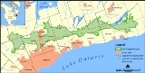
covers a geographic area of 1900 square kilometres (733.6 sq mi) between Caledon
and Rice Lake
, near Peterborough
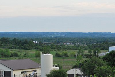
. One of the most significant landforms in southern Ontario
, the moraine gets its name from the rolling hills and river valleys extending 160 km (99.4 mi) from the Niagara Escarpment
east to Rice Lake. It was formed 12,000 years ago by advancing and retreating glaciers (see geological origins, below). The moraine is currently a contested site in Ontario, since it stands in the path of major urban development (see political action).
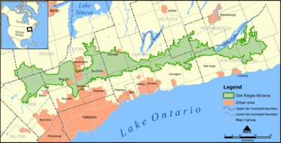
which was critical to the formation of the moraine, and to the east by the Trent River
and Rice Lake. The four wedges (Albion, Uxbridge, Pontypool and Rice Lake from west to east) formed in stages, though some synchronous formation also occurred at an early period of formation. The moraine peaks at the Uxbridge wedge, generally rising from east to west, a result of the moraine's west-to-east formation. That is, the western portion of the moraine received earlier and more frequent sedimentary deposition than the eastern portion, as the ice lobes which controlled the moraine's eastern formation slowly retreated. The Rice Lake wedge is separated from the other wedges where the Oak Ridges Moraine intersects Rice Lake.
To the north are drumlin
ized uplands, referred to as the Peterborough drumlin field.
glacial period. Ice melt from the Niagara Escarpment flowed into the western boundaries of the moraine, wherein conduits beneath the ice expanded to form a west-to-east passage between the main Laurentide ice sheet
and a mass of ice in the Lake Ontario basin.
Stratified sediment was deposited rapidly on the high-relief erosion
al surface. Up to 150 m (500 ft) in some areas, the deposits occurred on surfaces defined by highly eroded channels and drumlin
uplands. The channel tunnels were primarily created by the erosion from glacial rivers, a typical process before moraine formation.
Characteristic of this moraine is the transition of deposition layers from glaciofluvial
to glaciolacustrine
. Sedimentary glaciofluvial areas form the core of the Oak Ridges Moraine, though restricted to subglacial cavity fills of confined subaqueous fan
s. Overlaying this core is a glaciolacustrine sedimentary layer that is younger and topographically lower, principally in the delta
and basin
areas of the moraine.
In the late stages of its development, random unstratified accumulation (known as diamicton
) occurred along the ice margins. Whereas the glacial river deposits were more substantial by volume, the diamicton deposits represent a greater portion of the moraine's exposed surface. Research suggests that sedimentation occurred in a west to east sequence along the four main sedimentary wedges: Albion, Uxbridge, Pontytool and Rice Lake. The wedges may have formed in a relatively short period of time, perhaps no more than a few hundred years, as indicated by the annual deposition cycles in glacial lakes (known as varve
s) within the moraine sediments. However, the lowest beds in the moraine may have experienced synchronous sedimentation.
system of the Oak Ridges Moraine:
This hydrological system is inter-twined with a regional flow systems not bound by the morphological limits of the moraine. For this reason, environmentalists and researchers promote an aggressive protection strategy extending beyond the moraine, thus ensuring a contiguously protected hydrological system.
The preservation of aquifers is especially important, since they are used as a primary water source by some municipalities located on or near the moraine. These aquifers also discharge into tributaries that are the headwaters of creeks and rivers which eventually flow into Lake Simcoe, Lake Scugog and Lake Ontario.
The Oak Ridges Moraine Conservation Act
stipulates that any development which targets the moraine or nearby areas must satisfy several conditions, most prominently that each development leave a buffer zone of 30 metres (98 ft) between it and any hydrological feature; for a kettle lake, this measure is from the edge of the lake's catchment area.
The Oak Ridges Moraine's hydrological system is a major constituent of the Humber Watershed, so that any factors affecting the moraine may have an impact on the connected systems. A specific concern is urbanization, which affects water quality by increasing its load of metals and organic contaminants. A study by Cook et al. (1985) found an increase in mean annual runoff
, instantaneous discharge, and hydrograph peak flow as a result of urbanization: "...changes in land use coincided with changes in volumetric and time distribution aspects of hydrologic response".
 The ecologically diverse
moraine is the water source for many headwaters streams
flowing south into rivers that drain into Lake Ontario
and north into rivers that drain into Lake Scugog
and Lake Simcoe
. Varied landforms on the moraine, such as woodland
s, wetland
s, watercourses
, kettle lakes and bog
s, have provided an environment suitable for significant flora
and fauna
communities to develop and thrive. The moraine contains one of the last large contiguous forested spans in southern Ontario.
Some of the wide variety of plant and animal species found in the moraine are species at risk in Canada and Ontario, including the West Virginia White Butterfly
, Jefferson Salamander
, Red-shouldered Hawk
, and American Ginseng
. Unique ecosystems in the moraine include wetlands similar to those of boreal forests in Northern Ontario, and remnants of tallgrass prairie
and oak-pine savanna
that are globally threatened ecosystems. A representative portion of the moraine may be found in the Happy Valley Forests, in York Region, north of Toronto
.
conducted the first investigation of the moraine. He noted the elevation, and styled the area Oak Ridge, identifying the portion of moraine north of Toronto
. The moraine's extent was not established until 1863 when William Logan
conducted the Geological Survey of Canada.
Taylor formally defined the landform as the Oak Ridges Moraine in 1913. He described its extent to be from King
and Maple
in the west to the Trent River in the east. He also proposed that its origin was overlapping, interlobate glaciation retreat, between the Lake Ontario Lobe and the older Lake Simcoe Lobe. This has become the accepted explanation for the moraine's development, though research in the 1970s suggested the moraine may not be interlobate.
Research conducted in the 1990s revealed that the moraine has multiple origins: its eastern area has subglacial depositions (Gorrell and McCrae, 1993); early parts of the moraine were deposited in an esker
(Brennand and Shaw, 1994); and that the moraine is not continuous, but is composed of multiple depositional environments
: subglacial, ice-marginal and proglacial lacustrine (Barnett et al., 1998).
Current research efforts on the moraine are quite extensive. Because of the political implications of development on the moraine, and because its aquifers are a source of potable water for numerous communities, both federal and provincial governments have invested resources towards research on the moraine. The Geological Survey of Canada and Ontario Geological Survey
both investigate hydrostratigraphy
and hydrology throughout the moraine.
Palaeo-Indian hunter-gatherers were in this area between 10,000 - 7000 BC. The oldest artifact found in what is now Richmond Hill, Ontario, from these people, was a stone scraper about 40 mm long, at the Mortson Site, near Leslie Street and 19th Avenue. Other artifacts were found in a settlement site on the eastern shore of Lake Wilcox.
Archaic Iroqouis artifacts c. 1800 BC have also been found at the Silver Stream site, near the headwaters of the Rouge River on Leslie Street just north of Major Mackenzie Drive, and at the Esox site, on the eastern shore of Lake Wilcox.
(STORM) Coalition.
The Government of Ontario created the Oak Ridges Moraine Technical Working Committee in June 1991, with the aim of creating a regional planning strategy for the moraine. The plan was completed in 1994, but was subsequently dismissed in favour of local government administration of the affected lands. This led to intense development on some portions of the moraine.
In early 1999, developers targeted Richmond Hill for large subdivisions
on the moraine which would house over 100,000 people. On July 20, 1999, Minister of Municipal Affairs and Housing Steve Gilchrist
announced, on "Rouge Park Day", that he would be implementing a ban on all development on the Oak Ridges Moraine. This announcement sparked considerable opposition by the development industry which, in turn, attracted considerable media attention and public interest. A media campaign by environmental groups built on the public opposition of the developments, and the issue was transferred to the Ontario Municipal Board
(OMB) in 2000.
By May 2001, with the issue still unresolved, the provincial Conservative government announced a six-month moratorium on moraine development. A panel was formed to create a land-use plan consistent with the current "smart growth" policy. The plan was released in October 2001, and became the basis for the Oak Ridges Moraine Conservation Act, 2002, which divided the moraine into four zones with increasingly stringent controls on development in each. The Act prevented development of over 92% of the land mass of the moraine and only those development projects which had already received zoning and planning approval were allowed to be completed.
During the provincial election of 2003, the Liberal Party of Ontario
promised to terminate development on the moraine as part of their election campaign. The government, in its attempt to halt developments, proposed the North Pickering Land Exchange. This involved exchanging government-owned public lands in North Pickering
(the Seaton
lands) for privately-owned lands on the Oak Ridges Moraine in Richmond Hill and Uxbridge
. The exchange settled outstanding disputes being considered by the OMB involving moraine lands in Richmond Hill and Uxbridge.
Despite all these efforts, including the government's creation of a permanently protected Greenbelt
, the political struggle regarding the moraine continues.
Unless approved prior to the Oak Ridges Moraine Conservation Act coming into force in 2001 or through orders of the Ontario Municipal Board to the contrary, development on the Oak Ridges Moraine is restricted to the Settlement Area. Smaller-scale development which improves the ecological integrity of the moraine is permitted in other areas (i.e., tree farm), but is otherwise restricted. Given that the land-subdivision process is lengthy and that the Region of York is experiencing a shortage in servicing capacity, what often appears as "new" development in York Region on the moraine is in the majority of cases development which has had approval for many years.
on and below its surface, particularly in the headwaters. The estimated current population on the moraine land itself is roughly 200,000 but this number continues to grow at a frantic pace, with large urban developments occurring in Stouffville, Vaughan, Richmond Hill, Oak Ridges and Aurora. This rapid development is especially apparent in Oak Ridges, where land previously set aside for conservation has, as recently as 2009, been opened up by the Richmond Hill Town Council
for development. Another five million people live in close proximity. Use of the moraine
is currently under dispute; environmental groups such as the Sierra Club
maintain the area's delicate ecosystem
s are threatened by development pressures. Attractive forests and hilly relief typical of the moraine are a magnet for developers looking for building opportunities in the densely populated Greater Toronto Area
. However, many planners and residents see a need to preserve the moraine from the negative aspects of urban sprawl
.
Moreover, because it is a rich resource for sand and gravel, it has become a significant source of materials for the aggregate
industry of the Greater Toronto Area.
was formed. The ORMLT is a non-profit organization that raises funds to protect areas on the moraine through conservation easement
s and outright purchases. They have protected 6 square kilometres (1,482.6 acre). The Nature Conservancy of Canada
is also active and are raising funds to protect a 5.4 km² (1,334.4 acre) property called Happy Valley Forest.
Ecology
Ecology is the scientific study of the relations that living organisms have with respect to each other and their natural environment. Variables of interest to ecologists include the composition, distribution, amount , number, and changing states of organisms within and among ecosystems...
important geological
Geology
Geology is the science comprising the study of solid Earth, the rocks of which it is composed, and the processes by which it evolves. Geology gives insight into the history of the Earth, as it provides the primary evidence for plate tectonics, the evolutionary history of life, and past climates...
landform in the Mixedwood Plains
Mixedwood Plains
The Mixedwood Plains Ecozone is the Canadian ecozone with the most southerly extent, covering all of southwestern Ontario, and parts of central and northeastern Ontario and southern Quebec along the Saint Lawrence River...
of south-central Ontario
Ontario
Ontario is a province of Canada, located in east-central Canada. It is Canada's most populous province and second largest in total area. It is home to the nation's most populous city, Toronto, and the nation's capital, Ottawa....
, Canada
Canada
Canada is a North American country consisting of ten provinces and three territories. Located in the northern part of the continent, it extends from the Atlantic Ocean in the east to the Pacific Ocean in the west, and northward into the Arctic Ocean...
. The moraine
Moraine
A moraine is any glacially formed accumulation of unconsolidated glacial debris which can occur in currently glaciated and formerly glaciated regions, such as those areas acted upon by a past glacial maximum. This debris may have been plucked off a valley floor as a glacier advanced or it may have...
covers a geographic area of 1900 square kilometres (733.6 sq mi) between Caledon
Caledon, Ontario
Caledon is a town in the Regional Municipality of Peel in the Greater Toronto Area of Ontario, Canada. In terms of land use, Caledon is somewhat urban, though it is primarily rural in nature...
and Rice Lake
Rice Lake (Ontario)
Rice Lake is a lake located in south-eastern Ontario, in Northumberland County, south of Peterborough and the Kawartha lakes and north of Cobourg. The lake is part of the Trent-Severn Waterway, which flows into the lake by the Otonabee and out via the Trent. The lake is 32 km long and...
, near Peterborough
Peterborough, Ontario
Peterborough is a city on the Otonabee River in southern Ontario, Canada, 125 kilometres northeast of Toronto. The population of the City of Peterborough was 74,898 as of the 2006 census, while the census metropolitan area has a population of 121,428 as of a 2009 estimate. It presently ranks...
. One of the most significant landforms in southern Ontario
Southern Ontario
Southern Ontario is a region of the province of Ontario, Canada that lies south of the French River and Algonquin Park. Depending on the inclusion of the Parry Sound and Muskoka districts, its surface area would cover between 14 to 15% of the province. It is the southernmost region of...
, the moraine gets its name from the rolling hills and river valleys extending 160 km (99.4 mi) from the Niagara Escarpment
Niagara Escarpment
The Niagara Escarpment is a long escarpment, or cuesta, in the United States and Canada that runs westward from New York State, through Ontario, Michigan, Wisconsin and Illinois...
east to Rice Lake. It was formed 12,000 years ago by advancing and retreating glaciers (see geological origins, below). The moraine is currently a contested site in Ontario, since it stands in the path of major urban development (see political action).
Physiography
The Oak Ridges Moraine is a pair of large ridges composed of four elevated wedges. It is bounded to the west by the Niagara Escarpment, a cuestaCuesta
In structural geology and geomorphology, a cuesta is a ridge formed by gently tilted sedimentary rock strata in a homoclinal structure. Cuestas have a steep slope, where the rock layers are exposed on their edges, called an escarpment or, if more steep, a cliff...
which was critical to the formation of the moraine, and to the east by the Trent River
Trent River (Ontario)
The Trent River is a river in southeastern Ontario which flows from Rice Lake to empty into the Bay of Quinte on Lake Ontario. This river is part of the Trent-Severn Waterway which leads to Georgian Bay. The river is 90 km long...
and Rice Lake. The four wedges (Albion, Uxbridge, Pontypool and Rice Lake from west to east) formed in stages, though some synchronous formation also occurred at an early period of formation. The moraine peaks at the Uxbridge wedge, generally rising from east to west, a result of the moraine's west-to-east formation. That is, the western portion of the moraine received earlier and more frequent sedimentary deposition than the eastern portion, as the ice lobes which controlled the moraine's eastern formation slowly retreated. The Rice Lake wedge is separated from the other wedges where the Oak Ridges Moraine intersects Rice Lake.
To the north are drumlin
Drumlin
A drumlin, from the Irish word droimnín , first recorded in 1833, is an elongated whale-shaped hill formed by glacial ice acting on underlying unconsolidated till or ground moraine.-Drumlin formation:...
ized uplands, referred to as the Peterborough drumlin field.
Geological origins
The Oak Ridges Moraine probably formed in the Late WisconsonianWisconsin glaciation
The last glacial period was the most recent glacial period within the current ice age occurring during the last years of the Pleistocene, from approximately 110,000 to 10,000 years ago....
glacial period. Ice melt from the Niagara Escarpment flowed into the western boundaries of the moraine, wherein conduits beneath the ice expanded to form a west-to-east passage between the main Laurentide ice sheet
Laurentide ice sheet
The Laurentide Ice Sheet was a massive sheet of ice that covered hundreds of thousands of square miles, including most of Canada and a large portion of the northern United States, multiple times during Quaternary glacial epochs. It last covered most of northern North America between c. 95,000 and...
and a mass of ice in the Lake Ontario basin.
Stratified sediment was deposited rapidly on the high-relief erosion
Erosion
Erosion is when materials are removed from the surface and changed into something else. It only works by hydraulic actions and transport of solids in the natural environment, and leads to the deposition of these materials elsewhere...
al surface. Up to 150 m (500 ft) in some areas, the deposits occurred on surfaces defined by highly eroded channels and drumlin
Drumlin
A drumlin, from the Irish word droimnín , first recorded in 1833, is an elongated whale-shaped hill formed by glacial ice acting on underlying unconsolidated till or ground moraine.-Drumlin formation:...
uplands. The channel tunnels were primarily created by the erosion from glacial rivers, a typical process before moraine formation.
Characteristic of this moraine is the transition of deposition layers from glaciofluvial
Fluvial
Fluvial is used in geography and Earth science to refer to the processes associated with rivers and streams and the deposits and landforms created by them...
to glaciolacustrine
Glaciolacustrine deposits
Sediments deposited into lakes that have come from glaciers are called glaciolacustrine deposits. These lakes include ice margin lakes or other types formed from glacial erosion or deposition. Sediments in the bedload and suspended load are carried into lakes and deposited...
. Sedimentary glaciofluvial areas form the core of the Oak Ridges Moraine, though restricted to subglacial cavity fills of confined subaqueous fan
Subaqueous fan
A subaqueous fan is a fan-shaped deposit formed beneath water , and are commonly related to glaciers and crater lakes....
s. Overlaying this core is a glaciolacustrine sedimentary layer that is younger and topographically lower, principally in the delta
River delta
A delta is a landform that is formed at the mouth of a river where that river flows into an ocean, sea, estuary, lake, reservoir, flat arid area, or another river. Deltas are formed from the deposition of the sediment carried by the river as the flow leaves the mouth of the river...
and basin
Drainage basin
A drainage basin is an extent or an area of land where surface water from rain and melting snow or ice converges to a single point, usually the exit of the basin, where the waters join another waterbody, such as a river, lake, reservoir, estuary, wetland, sea, or ocean...
areas of the moraine.
In the late stages of its development, random unstratified accumulation (known as diamicton
Diamicton
In geology, diamicton is a very poorly sorted sediment. Large sedimentary grains gravel size and larger are set in a matrix of fine grains....
) occurred along the ice margins. Whereas the glacial river deposits were more substantial by volume, the diamicton deposits represent a greater portion of the moraine's exposed surface. Research suggests that sedimentation occurred in a west to east sequence along the four main sedimentary wedges: Albion, Uxbridge, Pontytool and Rice Lake. The wedges may have formed in a relatively short period of time, perhaps no more than a few hundred years, as indicated by the annual deposition cycles in glacial lakes (known as varve
Varve
A varve is an annual layer of sediment or sedimentary rock.The word 'varve' is derived from the Swedish word varv whose meanings and connotations include 'revolution', 'in layers', and 'circle'. The term first appeared as Hvarfig lera on the first map produced by the Geological Survey of Sweden in...
s) within the moraine sediments. However, the lowest beds in the moraine may have experienced synchronous sedimentation.
Hydrology
A number of features comprise the hydrologicalHydrology
Hydrology is the study of the movement, distribution, and quality of water on Earth and other planets, including the hydrologic cycle, water resources and environmental watershed sustainability...
system of the Oak Ridges Moraine:
- permanent and ephemeral streams,
- wetlands,
- kettle lakes and ponds, and their catchment areasDrainage basinA drainage basin is an extent or an area of land where surface water from rain and melting snow or ice converges to a single point, usually the exit of the basin, where the waters join another waterbody, such as a river, lake, reservoir, estuary, wetland, sea, or ocean...
, - seepage areas and springsSpring (hydrosphere)A spring—also known as a rising or resurgence—is a component of the hydrosphere. Specifically, it is any natural situation where water flows to the surface of the earth from underground...
, and - aquiferAquiferAn aquifer is a wet underground layer of water-bearing permeable rock or unconsolidated materials from which groundwater can be usefully extracted using a water well. The study of water flow in aquifers and the characterization of aquifers is called hydrogeology...
s and other recharge areas.
This hydrological system is inter-twined with a regional flow systems not bound by the morphological limits of the moraine. For this reason, environmentalists and researchers promote an aggressive protection strategy extending beyond the moraine, thus ensuring a contiguously protected hydrological system.
The preservation of aquifers is especially important, since they are used as a primary water source by some municipalities located on or near the moraine. These aquifers also discharge into tributaries that are the headwaters of creeks and rivers which eventually flow into Lake Simcoe, Lake Scugog and Lake Ontario.
The Oak Ridges Moraine Conservation Act
Oak Ridges Moraine Conservation Act
The Oak Ridges Moraine Conservation Act, officially known as the Oak Ridges Moraine Conservation Act, 2001, is a conservation plan for land situated on or near the Oak Ridges Moraine in Ontario, Canada...
stipulates that any development which targets the moraine or nearby areas must satisfy several conditions, most prominently that each development leave a buffer zone of 30 metres (98 ft) between it and any hydrological feature; for a kettle lake, this measure is from the edge of the lake's catchment area.
The Oak Ridges Moraine's hydrological system is a major constituent of the Humber Watershed, so that any factors affecting the moraine may have an impact on the connected systems. A specific concern is urbanization, which affects water quality by increasing its load of metals and organic contaminants. A study by Cook et al. (1985) found an increase in mean annual runoff
Surface runoff
Surface runoff is the water flow that occurs when soil is infiltrated to full capacity and excess water from rain, meltwater, or other sources flows over the land. This is a major component of the water cycle. Runoff that occurs on surfaces before reaching a channel is also called a nonpoint source...
, instantaneous discharge, and hydrograph peak flow as a result of urbanization: "...changes in land use coincided with changes in volumetric and time distribution aspects of hydrologic response".
Ecology
Biodiversity
Biodiversity is the degree of variation of life forms within a given ecosystem, biome, or an entire planet. Biodiversity is a measure of the health of ecosystems. Biodiversity is in part a function of climate. In terrestrial habitats, tropical regions are typically rich whereas polar regions...
moraine is the water source for many headwaters streams
Source (river or stream)
The source or headwaters of a river or stream is the place from which the water in the river or stream originates.-Definition:There is no universally agreed upon definition for determining a stream's source...
flowing south into rivers that drain into Lake Ontario
Lake Ontario
Lake Ontario is one of the five Great Lakes of North America. It is bounded on the north and southwest by the Canadian province of Ontario, and on the south by the American state of New York. Ontario, Canada's most populous province, was named for the lake. In the Wyandot language, ontarío means...
and north into rivers that drain into Lake Scugog
Lake Scugog
Lake Scugog is an artificially flooded lake in Scugog Township between the town of Port Perry, Ontario and the town of Lindsay. The lake has been raised and lowered several times over its history. Though not technically part of the Kawarthas due to its shallow depths, it is often geographically...
and Lake Simcoe
Lake Simcoe
Lake Simcoe is a lake in Southern Ontario, Canada, the fourth-largest lake wholly in the province, after Lake Nipigon, Lac Seul, and Lake Nipissing. At the time of the first European contact in the 17th century the lake was called Ouentironk by the Huron natives...
. Varied landforms on the moraine, such as woodland
Woodland
Ecologically, a woodland is a low-density forest forming open habitats with plenty of sunlight and limited shade. Woodlands may support an understory of shrubs and herbaceous plants including grasses. Woodland may form a transition to shrubland under drier conditions or during early stages of...
s, wetland
Wetland
A wetland is an area of land whose soil is saturated with water either permanently or seasonally. Wetlands are categorised by their characteristic vegetation, which is adapted to these unique soil conditions....
s, watercourses
Waterway
A waterway is any navigable body of water. Waterways can include rivers, lakes, seas, oceans, and canals. In order for a waterway to be navigable, it must meet several criteria:...
, kettle lakes and bog
Bog
A bog, quagmire or mire is a wetland that accumulates acidic peat, a deposit of dead plant material—often mosses or, in Arctic climates, lichens....
s, have provided an environment suitable for significant flora
Flora
Flora is the plant life occurring in a particular region or time, generally the naturally occurring or indigenous—native plant life. The corresponding term for animals is fauna.-Etymology:...
and fauna
Fauna
Fauna or faunæ is all of the animal life of any particular region or time. The corresponding term for plants is flora.Zoologists and paleontologists use fauna to refer to a typical collection of animals found in a specific time or place, e.g. the "Sonoran Desert fauna" or the "Burgess shale fauna"...
communities to develop and thrive. The moraine contains one of the last large contiguous forested spans in southern Ontario.
Some of the wide variety of plant and animal species found in the moraine are species at risk in Canada and Ontario, including the West Virginia White Butterfly
West Virginia White Butterfly
The West Virginia White Butterfly is a common butterfly found in the Great Lakes states, along the Appalachians from New England to Alabama, and in southern Ontario...
, Jefferson Salamander
Jefferson Salamander
The Jefferson salamander is a mole salamander native to the northeastern United States, southern and central Ontario, and southwestern Quebec. It was named after Jefferson College in Pennsylvania....
, Red-shouldered Hawk
Red-shouldered Hawk
The Red-shouldered Hawk is a medium-sized hawk. Its breeding range spans eastern North America and along the coast of California and northern to northeastern-central Mexico.-Description:...
, and American Ginseng
Ginseng
Ginseng is any one of eleven species of slow-growing perennial plants with fleshy roots, belonging to the genus Panax of the family Araliaceae....
. Unique ecosystems in the moraine include wetlands similar to those of boreal forests in Northern Ontario, and remnants of tallgrass prairie
Tallgrass prairie
The tallgrass prairie is an ecosystem native to central North America, with fire as its primary periodic disturbance. In the past, tallgrass prairies covered a large portion of the American Midwest, just east of the Great Plains, and portions of the Canadian Prairies. They flourished in areas with...
and oak-pine savanna
Savanna
A savanna, or savannah, is a grassland ecosystem characterized by the trees being sufficiently small or widely spaced so that the canopy does not close. The open canopy allows sufficient light to reach the ground to support an unbroken herbaceous layer consisting primarily of C4 grasses.Some...
that are globally threatened ecosystems. A representative portion of the moraine may be found in the Happy Valley Forests, in York Region, north of Toronto
Toronto
Toronto is the provincial capital of Ontario and the largest city in Canada. It is located in Southern Ontario on the northwestern shore of Lake Ontario. A relatively modern city, Toronto's history dates back to the late-18th century, when its land was first purchased by the British monarchy from...
.
Research on the moraine
In 1829, John BigsbyJohn Jeremiah Bigsby
John Jeremiah Bigsby , English geologist and physician, the son of Dr. John Bigsby, was born at Nottingham on the 14th of August 1792....
conducted the first investigation of the moraine. He noted the elevation, and styled the area Oak Ridge, identifying the portion of moraine north of Toronto
Toronto
Toronto is the provincial capital of Ontario and the largest city in Canada. It is located in Southern Ontario on the northwestern shore of Lake Ontario. A relatively modern city, Toronto's history dates back to the late-18th century, when its land was first purchased by the British monarchy from...
. The moraine's extent was not established until 1863 when William Logan
William Edmond Logan
Sir William Edmond Logan was a Scottish-Canadian geologist.Logan was born in Montreal, Quebec, and educated at the High School in Edinburgh and the University of Edinburgh . He started teaching himself geology in 1831, when he took over the running of a copper works in Swansea. He produced a...
conducted the Geological Survey of Canada.
Taylor formally defined the landform as the Oak Ridges Moraine in 1913. He described its extent to be from King
King, Ontario
King is a township in York Region north of Toronto, within the Greater Toronto Area in Ontario, Canada.The rolling hills of the Oak Ridges Moraine are the most prominent visible geographical feature of King. The Holland Marsh, considered to be Ontario's "vegetable basket", straddles King Township...
and Maple
Maple, Ontario
Maple is a high-growth suburban community northwest of Toronto, Ontario, Canada, part of the city of Vaughan in York Region.-Geography:The west branch of the Don River rises to the northwest and flows 1 km west of Maple. Several creeks are to the east and the Black Creek begins slightly west...
in the west to the Trent River in the east. He also proposed that its origin was overlapping, interlobate glaciation retreat, between the Lake Ontario Lobe and the older Lake Simcoe Lobe. This has become the accepted explanation for the moraine's development, though research in the 1970s suggested the moraine may not be interlobate.
Research conducted in the 1990s revealed that the moraine has multiple origins: its eastern area has subglacial depositions (Gorrell and McCrae, 1993); early parts of the moraine were deposited in an esker
Esker
An esker is a long winding ridge of stratified sand and gravel, examples of which occur in glaciated and formerly glaciated regions of Europe and North America...
(Brennand and Shaw, 1994); and that the moraine is not continuous, but is composed of multiple depositional environments
Sedimentary depositional environment
In geology, sedimentary depositional environment describes the combination of physical, chemical and biological processes associated with the deposition of a particular type of sediment and, therefore, the rock types that will be formed after lithification, if the sediment is preserved in the rock...
: subglacial, ice-marginal and proglacial lacustrine (Barnett et al., 1998).
Current research efforts on the moraine are quite extensive. Because of the political implications of development on the moraine, and because its aquifers are a source of potable water for numerous communities, both federal and provincial governments have invested resources towards research on the moraine. The Geological Survey of Canada and Ontario Geological Survey
Ontario Geological Survey
The Ontario Geological Survey is an administrative Branch of the Ontario Ministry of Northern Development, Mines and Forestry. It is responsible for documenting and communicating the geology of Ontario, and manages the Assessment File Research Imaging database.OGS helps people understand how to...
both investigate hydrostratigraphy
Stratigraphy
Stratigraphy, a branch of geology, studies rock layers and layering . It is primarily used in the study of sedimentary and layered volcanic rocks....
and hydrology throughout the moraine.
Palaeo-Indian hunter-gatherers were in this area between 10,000 - 7000 BC. The oldest artifact found in what is now Richmond Hill, Ontario, from these people, was a stone scraper about 40 mm long, at the Mortson Site, near Leslie Street and 19th Avenue. Other artifacts were found in a settlement site on the eastern shore of Lake Wilcox.
Archaic Iroqouis artifacts c. 1800 BC have also been found at the Silver Stream site, near the headwaters of the Rouge River on Leslie Street just north of Major Mackenzie Drive, and at the Esox site, on the eastern shore of Lake Wilcox.
Political action
Although preservation of the moraine was first suggested in the 1940s, it was not until 1991 that the issue achieved prominence in political discourse. Part of the reason for its entry into political discourse, was due to the formation, in 1989, of the Save the Oak Ridges MoraineSave the Oak Ridges Moraine
Save the Oak Ridges Moraine is a coalition of 25 citizen's groups and individuals dedicated to preserving the ecologically sensitive Oak Ridges Moraine in Ontario, Canada...
(STORM) Coalition.
The Government of Ontario created the Oak Ridges Moraine Technical Working Committee in June 1991, with the aim of creating a regional planning strategy for the moraine. The plan was completed in 1994, but was subsequently dismissed in favour of local government administration of the affected lands. This led to intense development on some portions of the moraine.
In early 1999, developers targeted Richmond Hill for large subdivisions
Subdivision (land)
Subdivision is the act of dividing land into pieces that are easier to sell or otherwise develop, usually via a plat. The former single piece as a whole is then known in the United States as a subdivision...
on the moraine which would house over 100,000 people. On July 20, 1999, Minister of Municipal Affairs and Housing Steve Gilchrist
Steve Gilchrist
Steve Gilchrist is a politician in Ontario, Canada. He was a Progressive Conservative member of the Legislative Assembly of Ontario from 1995 to 2003, and served as a cabinet minister in the government of Mike Harris....
announced, on "Rouge Park Day", that he would be implementing a ban on all development on the Oak Ridges Moraine. This announcement sparked considerable opposition by the development industry which, in turn, attracted considerable media attention and public interest. A media campaign by environmental groups built on the public opposition of the developments, and the issue was transferred to the Ontario Municipal Board
Ontario Municipal Board
The Ontario Municipal Board is an independent administrative board, operated as an adjudicative tribunal, in the province of Ontario, Canada...
(OMB) in 2000.
By May 2001, with the issue still unresolved, the provincial Conservative government announced a six-month moratorium on moraine development. A panel was formed to create a land-use plan consistent with the current "smart growth" policy. The plan was released in October 2001, and became the basis for the Oak Ridges Moraine Conservation Act, 2002, which divided the moraine into four zones with increasingly stringent controls on development in each. The Act prevented development of over 92% of the land mass of the moraine and only those development projects which had already received zoning and planning approval were allowed to be completed.
During the provincial election of 2003, the Liberal Party of Ontario
Ontario Liberal Party
The Ontario Liberal Party is a provincial political party in the province of Ontario, Canada. It has formed the Government of Ontario since the provincial election of 2003. The party is ideologically aligned with the Liberal Party of Canada but the two parties are organizationally independent and...
promised to terminate development on the moraine as part of their election campaign. The government, in its attempt to halt developments, proposed the North Pickering Land Exchange. This involved exchanging government-owned public lands in North Pickering
Pickering, Ontario
Pickering is a city located in Southern Ontario, Canada immediately east of Toronto in Durham Region. It is part of the Greater Toronto Area, the largest metropolitan area in Canada.- Early Period :...
(the Seaton
Seaton, Ontario
Seaton is a section of north Pickering in Ontario, Canada. Seaton includes the communities of Cherrywood, Green River, and Whitevale, as well as the southern edge of Brougham.-Politics:...
lands) for privately-owned lands on the Oak Ridges Moraine in Richmond Hill and Uxbridge
Uxbridge, Ontario
Uxbridge is a township in south-central Ontario, Canada, in the Regional Municipality of Durham, in the Greater Toronto Area.The main centre in the township is the namesake community of Uxbridge...
. The exchange settled outstanding disputes being considered by the OMB involving moraine lands in Richmond Hill and Uxbridge.
Despite all these efforts, including the government's creation of a permanently protected Greenbelt
Greenbelt (Golden Horseshoe)
The Greenbelt is a permanently protected area of green space, farmland, forests, wetlands, and watersheds, located in Southern Ontario, Canada. It surrounds a significant portion of Canada's most populated and fastest-growing area - The Golden Horseshoe....
, the political struggle regarding the moraine continues.
Unless approved prior to the Oak Ridges Moraine Conservation Act coming into force in 2001 or through orders of the Ontario Municipal Board to the contrary, development on the Oak Ridges Moraine is restricted to the Settlement Area. Smaller-scale development which improves the ecological integrity of the moraine is permitted in other areas (i.e., tree farm), but is otherwise restricted. Given that the land-subdivision process is lengthy and that the Region of York is experiencing a shortage in servicing capacity, what often appears as "new" development in York Region on the moraine is in the majority of cases development which has had approval for many years.
Development pressures
The greatest threat to the function of the moraine is land developmentLand development
Land development refers to altering the landscape in any number of ways such as:* changing landforms from a natural or semi-natural state for a purpose such as agriculture or housing...
on and below its surface, particularly in the headwaters. The estimated current population on the moraine land itself is roughly 200,000 but this number continues to grow at a frantic pace, with large urban developments occurring in Stouffville, Vaughan, Richmond Hill, Oak Ridges and Aurora. This rapid development is especially apparent in Oak Ridges, where land previously set aside for conservation has, as recently as 2009, been opened up by the Richmond Hill Town Council
Richmond Hill Town Council
Richmond Hill Town Council is the governing body for the Town of Richmond Hill, Ontario, Canada. Council serves a four year term, after which a new council is elected by qualified electors in Richmond Hill. Richmond Hill Town council consists of a Mayor, six Ward Councillors and two Regional and...
for development. Another five million people live in close proximity. Use of the moraine
Moraine
A moraine is any glacially formed accumulation of unconsolidated glacial debris which can occur in currently glaciated and formerly glaciated regions, such as those areas acted upon by a past glacial maximum. This debris may have been plucked off a valley floor as a glacier advanced or it may have...
is currently under dispute; environmental groups such as the Sierra Club
Sierra Club
The Sierra Club is the oldest, largest, and most influential grassroots environmental organization in the United States. It was founded on May 28, 1892, in San Francisco, California, by the conservationist and preservationist John Muir, who became its first president...
maintain the area's delicate ecosystem
Ecosystem
An ecosystem is a biological environment consisting of all the organisms living in a particular area, as well as all the nonliving , physical components of the environment with which the organisms interact, such as air, soil, water and sunlight....
s are threatened by development pressures. Attractive forests and hilly relief typical of the moraine are a magnet for developers looking for building opportunities in the densely populated Greater Toronto Area
Greater Toronto Area
The Greater Toronto Area is the largest metropolitan area in Canada, with a 2006 census population of 5.5 million. The Greater Toronto Area is usually defined as the central city of Toronto, along with four regional municipalities surrounding it: Durham, Halton, Peel, and York...
. However, many planners and residents see a need to preserve the moraine from the negative aspects of urban sprawl
Urban sprawl
Urban sprawl, also known as suburban sprawl, is a multifaceted concept, which includes the spreading outwards of a city and its suburbs to its outskirts to low-density and auto-dependent development on rural land, high segregation of uses Urban sprawl, also known as suburban sprawl, is a...
.
Moreover, because it is a rich resource for sand and gravel, it has become a significant source of materials for the aggregate
Aggregate (composite)
Aggregate is the component of a composite material that resists compressive stress and provides bulk to the composite material. For efficient filling, aggregate should be much smaller than the finished item, but have a wide variety of sizes...
industry of the Greater Toronto Area.
Conservation
Local concerns for preserving wildlife habitat on the moraine have increased in recent years. In April 2000, the Oak Ridges Moraine Land TrustOak Ridges Moraine Land Trust
The Oak Ridges Moraine Land Trust is a Canadian charitable non-profit organization founded in 1999. Its mandate is to acquire land on the Oak Ridges Moraine to protect it from development, typically through land donations or conservation easements. As of November 2008, it has secured over 3000...
was formed. The ORMLT is a non-profit organization that raises funds to protect areas on the moraine through conservation easement
Conservation easement
In the United States, a conservation easement is an encumbrance — sometimes including a transfer of usage rights — which creates a legally enforceable land preservation agreement between a landowner and a government agency or a qualified land...
s and outright purchases. They have protected 6 square kilometres (1,482.6 acre). The Nature Conservancy of Canada
Nature Conservancy of Canada
Nature Conservancy of Canada is a Canadian private not-for-profit charitable environmental organisation established in 1962. The NCC works to achieve the direct protection of what they deem as Canada's most important natural treasures through property securement and long-term stewardship of...
is also active and are raising funds to protect a 5.4 km² (1,334.4 acre) property called Happy Valley Forest.
External links
- Government of Ontario - Ministry of Municipal Affairs and Housing: The Oak Ridges Moraine
- Natural Resources Canada - Earth Sciences Sector: Oak Ridges Moraine Groundwater Research
- Natural Resources Canada: Oak Ridges Moraine - A Ridge of Resources
- Nature Conservancy Canada: The Oak Ridges Moraine
- Oak Ridges Moraine Land Trust