

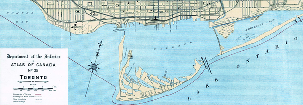
Toronto Harbour
Encyclopedia
Toronto Harbour or Toronto Bay is a bay on the north shore of Lake Ontario
, in Toronto
, Ontario
, Canada
. It is a natural harbour, protected from Lake Ontario waves by the Toronto Islands
. It is a commercial port on the Great Lakes as well as a recreational harbour. Waterfront uses include shipping, residential, recreational and cultural.
, a conversion from industrial land to recreational and cultural uses. Harbourfront has parks, hotels, an amphitheatre, and many other facilities. The Toronto Islands are also mostly recreational, although they do also contain a small community and an airport.
Toronto also has a second harbour, called the Outer Harbour (Toronto Harbour is sometimes called the Inner Harbour), but it never developed into a commercially viable project. It was created in the 1950s by the Toronto Harbour Commission
through the construction of a new breakwater
called the Outer Harbour East Headland. At that time, it was expected that there would be a great upswing in the number of ships calling at Toronto once the Saint Lawrence Seaway
opened. However, the need for an extra harbour never materialized, and private boats
are the only traffic usually found there now.
Tonnage
Today, the tonnage of cargo passing through the port is made up mostly of sugar to the Redpath refinery and aggregate materials.
 The original shoreline of the northern shore were low sandy bluffs, just south of today's Front Street. The mouth of the harbour pointed west. Fort York
, on the north shore of the bay, near the mouth of Garrison Creek, guarded the harbour's mouth. It was briefly captured by American forces during the War of 1812.
The islands were originally a low sandy peninsula forming the southern limit of the bay. The Scarborough Bluffs are much larger bluffs that lie approximately ten kilometres east of the harbour. Strong lake currents over time washed the sand eroded from the bluffs westwards to form the peninsula surrounding the bay.
The peninsula became the Toronto Islands
through the result of two storms and man-made activity. In 1852, a storm created a channel through the eastern edge of the peninsula that formed the south edge of the bay. The storm washed through excavations made for sand for local construction. In 1858, another storm widened the channel and made it permanent.
The eastern shore of the bay, approximately six kilometres east, was a marsh around the mouth of the Don River
. In addition to the Don River a number of smaller creeks flowed into the bay. The original site of the town of York
had half a dozen short creeks that flowed through it. As the town developed they all became polluted, and were buried. As the city grew the larger two creeks, Taddle Creek
and Garrison Creek
, were also filled in.
was built on the island to guide ships.
In the early 19th century, cargoes destined for York would be transferred at Montreal to smaller boats such as Durham boats and batteaux to traverse the rapids of the St. Lawrence River. In 1825, the Lachine Canal was built to bypass the Lachine Rapids. Some of the boats used for cargo were now being built at Toronto Bay. Although not fully established by the War of 1812
, the British colonial army was determined to set up boat-building for defense at York. The Sir Isaac Brock, an armed schooner was under construction, when the Americans attacked and the British burned the hull rather than surrender it. The invaders looted the town and destroyed military facilities.
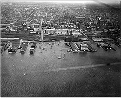
By the time of the establishment of the Town of Toronto, three large wharves existed for shipping, King's Wharf at Peter Street, Cooper's Wharf at Church Street and Merchant's Wharf at Caroline Street (today's Sherbourne Street). The new Queen's Wharf, at the foot of Bathurst Street was constructed in two stages, eventually reaching 244 feet (74.4 m) in length. Commissioned by the Province of Upper Canada, it cost £4,500. The first harbourmaster of Toronto, Hugh Richardson, was named in 1833. Richardson held the position until 1870. While the Queen's Wharf no longer exists, the Queen's Wharf Lighthouse still exists, eventually moved to a location off today's Lakeshore Boulevard in 1929. In 1849, the Harbour Trust was formed to manage the port and the Queen's Wharf.
In 1832, the Gooderham and Worts Distillery went into operation, using a windmill on the waterfront, near the Don River, to provide power. The Distillery was originally conceived as a plant to make flour, but the distillery business was much more popular. By 1837, the mill was producing more than 28000 gal of whiskey annually.
By 1840, the waterfront was completely taken over by government and merchant wharves. The Esplanade, a 100 feet (30.5 m)-wide road, was proposed, just south of Front Street, with new water lots made from cribbing and filling of the shore to the south. The waterfront was extended to a survey line from the point of the Gooderham windmill west to a point due east of the old Fort Rouille
. Ostensibly for carriages and carts, the roadway eventually became primarily the route for rail lines in the central core. In exchange for 40 feet (12.2 m) of the Esplanade, the railways underwrote the infilling of the harbour. The Esplanade and infill project was complete by 1865. A section of The Esplanade from Yonge Street to Berkeley Street still exists as a roadway. The rail lines moved to a viaduct in the 20th century.
The first rail line to the harbour was the Ontario, Simcoe and Huron Railroad in 1853. The next rail line was the Grand Trunk, which underwrote the Esplanade project in exchange for an easement to enter the City. The Canadian Pacific Railway arrived in 1886, through the purchase of the Credit Valley Railway. Most of the area along the shoreline was connected to the railways. Manufacturers of products such as soap received raw materials via boat, produced the product at their location on the harbour, and distributed it via rail.
As well as cargo, the harbour also became a major passenger waypoint. By the 1880s, the harbour was handling 1,250,000 passengers annually through passenger steamship docks at the foot of Yonge Street. Passenger boats operated on Lake Ontario and the St. Lawrence River. Excursions to Niagara also departed from the Yonge Street docks.
The western channel's depth was found to be too shallow by 1906 when the steam barge Resolute sank outside the harbour during a storm. The barge was unable to shelter in the harbour. The Queen's Wharf area was rebuilt during the years of 1908 to 1911 by the federal government. A new western channel was dug 1300 feet (396.2 m) to the south of the existing one. The existing channel could not be dredged to a lower depth as it was solid rock. The Queen's Wharf site became the eventual site of the Loblaws warehouse at the intersection of Bathurst Street and Fleet Street.
The 1910 Toronto Board of Trade
proposal for the Ashbridge's Bay was for an industrial district for industrial offices and sites served by railway lines, public warehouses alongside docking facilities south of Keating Channel
to the Eastern Gap and parkland/recreational strip at the south end.
In 1911, the Toronto Harbour Commission was created. The lands of the waterfront that were owned by the City of Toronto were transferred to the Commission to administer. In 1912, the Commission delivered its first plan for the harbour and the waterfront from the Humber River in the west, to Woodbine Avenue to the east. The Commission dredged the harbour to a depth of 24 feet (7.3 m) to match the new Welland Canal.
As the city of Toronto grew the northern shore of the bay was further altered by landfill, and has been moved approximately 500 meters south. After the Esplanade landfill, the second landfill project extended the shoreline south of today's Queens' Quay to the west of Yonge Street. The final infill on the north shore was in the 1950s, from Yonge Street east to the Don River, providing room for the Redpath Sugar Refinery, the Victory Soy Mills and several marine terminals.
In the 1920s, most of the low-lying marsh of Ashbridge's Bay was filled in to create Toronto's inner harbour area (with the small section to the east and the shipping channel the only reminder of the body of water). In the 1930s, the waters of Hanlan's Bay on the western point of the islands were infilled to create the Toronto Island Airport, now known as Billy Bishop Toronto City Airport.
By the time that the plans to build the St. Lawrence Seaway were announced, commercial usage of the harbour was already in decline. Previous infill on the eastern side created in the 1920s was used to build modern port facilities. In the 1970s, the northern shore was in decline and there was a new political initiative to rebuild the waterfront without industry in a manner seen in other cities. The Harbourfront
project expropriated the lands west of York Street. Several facilities were renovated, such as the Terminal Warehouse, and others were demolished, creating space for recreational and cultural uses. The area around Yonge Street remained in private possession and a hotel and condominiums were built on the shoreline. The area east of Yonge Street remained in light industrial use under public possession. On the north side of the harbour, there are a few buildings left from the industrial period. Some are in use, such as the Redpath Sugar Refinery. Others have been demolished or are slated for demolition, including grain storage elevators at the east and west end of the harbours.
A list of former wharves along the central waterfront:
 A list of current quays/slips along the waterfront:
(CATS) began regular passenger/vehicle ferry service between Pier 52 and Rochester, New York
using the vessel Spirit of Ontario I. The service used a marketing name called "The Breeze". While Rochester had a custom-built ferry terminal, the Toronto terminal was a temporary facility, near the end of Cherry Street for security and customs screening facilities while a permanent marine passenger terminal was still under consideration for construction. CATS discontinued the service after only 11 weeks; among the problems cited was the absence of a permanent marine passenger terminal in Toronto and literally no Canadian interest in the service. The Toronto Economic Development Corp (TEDCO) was not properly consulted by the American interests who combined with the Mayor saw little political favour in seeing the project through from the City of Toronto's point of view. The vessel was sold in a bankruptcy sale in February 2005 to Rochester Ferry Company LLC, a subsidiary of the City of Rochester. In April 2005, Rochester Ferry Company LLC announced that the Rochester-Toronto ferry service using Spirit of Ontario I would return, operated by Bay Ferries Great Lakes Limited and using the marketing name "The Cat". The Toronto Port Authority officially opened the International Marine Passenger Terminal on June 27, 2005, three days before ferry service resumed. Even with impressive passenger numbers by the winter of 2006 the ferry service lost funding from the City of Rochester and announced that it would no longer be in business. The terminal building was later used for filming the CBC
crime drama The Border
.
is Toronto's legend
ary Loch Ness Monster
and it is sometimes spotted in Lake Ontario
and even within the Toronto Harbour. The story of Gaasyendietha is a Native Canadian myth
from the Seneca tribe
.
Lake Ontario
Lake Ontario is one of the five Great Lakes of North America. It is bounded on the north and southwest by the Canadian province of Ontario, and on the south by the American state of New York. Ontario, Canada's most populous province, was named for the lake. In the Wyandot language, ontarío means...
, in Toronto
Toronto
Toronto is the provincial capital of Ontario and the largest city in Canada. It is located in Southern Ontario on the northwestern shore of Lake Ontario. A relatively modern city, Toronto's history dates back to the late-18th century, when its land was first purchased by the British monarchy from...
, Ontario
Ontario
Ontario is a province of Canada, located in east-central Canada. It is Canada's most populous province and second largest in total area. It is home to the nation's most populous city, Toronto, and the nation's capital, Ottawa....
, Canada
Canada
Canada is a North American country consisting of ten provinces and three territories. Located in the northern part of the continent, it extends from the Atlantic Ocean in the east to the Pacific Ocean in the west, and northward into the Arctic Ocean...
. It is a natural harbour, protected from Lake Ontario waves by the Toronto Islands
Toronto Islands
The Toronto Islands are a chain of small islands in the city of Toronto, Ontario. Comprising the only group of islands in the western part of Lake Ontario, the Toronto Islands are located just offshore from the city centre, and provide shelter for Toronto Harbour...
. It is a commercial port on the Great Lakes as well as a recreational harbour. Waterfront uses include shipping, residential, recreational and cultural.
Port
Toronto Harbour is both a commercial port and a recreation area. Commercial activities are confined mainly to the harbour's eastern side, while the western side was developed into HarbourfrontHarbourfront
Harbourfront is a neighbourhood on the northern shore of Lake Ontario within the downtown core of the city of Toronto, Canada. Part of the Toronto Waterfront, Harbourfront extends west from Yonge Street to Bathurst Street along Queen's Quay. East of Yonge to Parliament St...
, a conversion from industrial land to recreational and cultural uses. Harbourfront has parks, hotels, an amphitheatre, and many other facilities. The Toronto Islands are also mostly recreational, although they do also contain a small community and an airport.
Toronto also has a second harbour, called the Outer Harbour (Toronto Harbour is sometimes called the Inner Harbour), but it never developed into a commercially viable project. It was created in the 1950s by the Toronto Harbour Commission
Toronto Harbour Commission
The Toronto Harbour Commission was a joint federal-municipal government agency based in Toronto, Ontario, Canada. The agency managed Toronto Harbour as well as being responsible for major works along the Toronto waterfront. It built the Toronto Island Airport in 1939...
through the construction of a new breakwater
Breakwater (structure)
Breakwaters are structures constructed on coasts as part of coastal defence or to protect an anchorage from the effects of weather and longshore drift.-Purposes of breakwaters:...
called the Outer Harbour East Headland. At that time, it was expected that there would be a great upswing in the number of ships calling at Toronto once the Saint Lawrence Seaway
Saint Lawrence Seaway
The Saint Lawrence Seaway , , is the common name for a system of locks, canals and channels that permits ocean-going vessels to travel from the Atlantic Ocean to the North American Great Lakes, as far as Lake Superior. Legally it extends from Montreal to Lake Erie, including the Welland Canal...
opened. However, the need for an extra harbour never materialized, and private boats
Boating
Boating is the leisurely activity of travelling by boat, or the recreational use of a boat whether powerboats, sailboats, or man-powered vessels , focused on the travel itself, as well as sports activities, such as fishing or water skiing...
are the only traffic usually found there now.
Tonnage
Today, the tonnage of cargo passing through the port is made up mostly of sugar to the Redpath refinery and aggregate materials.
- In 2007, the port handled 1.6 million tonnes of traffic, a 0.3% share of national port traffic, 16th out of 19 Canada Port Authority ports by traffic.
- In 2006, Transport Canada ranked Toronto 39th out of 313 ports in all of Canada in total tonnage shipped.
- Statistics Canada ranks the port 15th in shipping activity in Ontario.
History
Fort York
Fort York is a historic site of military fortifications and related buildings on the west side of downtown Toronto, Ontario, Canada. The fort was built by the British Army and Canadian militia troops in the late 18th and early 19th centuries, to defend the settlement and the new capital of the...
, on the north shore of the bay, near the mouth of Garrison Creek, guarded the harbour's mouth. It was briefly captured by American forces during the War of 1812.
The islands were originally a low sandy peninsula forming the southern limit of the bay. The Scarborough Bluffs are much larger bluffs that lie approximately ten kilometres east of the harbour. Strong lake currents over time washed the sand eroded from the bluffs westwards to form the peninsula surrounding the bay.
The peninsula became the Toronto Islands
Toronto Islands
The Toronto Islands are a chain of small islands in the city of Toronto, Ontario. Comprising the only group of islands in the western part of Lake Ontario, the Toronto Islands are located just offshore from the city centre, and provide shelter for Toronto Harbour...
through the result of two storms and man-made activity. In 1852, a storm created a channel through the eastern edge of the peninsula that formed the south edge of the bay. The storm washed through excavations made for sand for local construction. In 1858, another storm widened the channel and made it permanent.
The eastern shore of the bay, approximately six kilometres east, was a marsh around the mouth of the Don River
Don River (Toronto)
The Don River is one of two rivers bounding the original settled area of Toronto, Ontario along the shore of Lake Ontario, the other being the Humber River to the west. The Don is formed from two rivers, the East and West Branches, that meet about north of Lake Ontario while flowing southward into...
. In addition to the Don River a number of smaller creeks flowed into the bay. The original site of the town of York
York, Ontario
York is a dissolved municipality in Toronto, Ontario, Canada. Geographically, it is located northwest of Old Toronto, southwest of North York and east of Etobicoke, where it is bounded by the Humber River. Formerly a separate city, it was one of six municipalities that amalgamated in 1998 to form...
had half a dozen short creeks that flowed through it. As the town developed they all became polluted, and were buried. As the city grew the larger two creeks, Taddle Creek
Taddle Creek
Taddle Creek is a buried stream in Toronto, Ontario, Canada that flowed a southeasterly course about six kilometres long, from the present site of Wychwood Park through the University of Toronto, into the Toronto Harbour near the Distillery District. During the 19th century, it was buried and...
and Garrison Creek
Garrison Creek
Garrison Creek was a short stream about long that flowed southeast into the west side of Toronto Harbour in Ontario, Canada.It has been largely covered over and filled in, but geographical traces of the creek can still be found. The natural amphitheatre known as Christie Pits is one such remnant;...
, were also filled in.
Development
The town of York was established in 1793 in a ten-block rectangle bounded by the present Front Street, Berkeley, Duke(now Adelaide) and George Street. A government wharf was built to handle the transfer of ships' cargoes. A garrison at the entrance to the harbour, at the mouth of Garrison Creek, was established to guard the harbour along with a blockhouse on the island. In 1801, York became an official port-of-entry for immigrants and cargo. In 1808, the Gibraltar Point lighthouseGibraltar Point Lighthouse
The Gibraltar Point Lighthouse is a lighthouse located on the Toronto Islands in Toronto, Ontario. Completed in 1808, it is the oldest existing lighthouse on the Great Lakes.- History :...
was built on the island to guide ships.
In the early 19th century, cargoes destined for York would be transferred at Montreal to smaller boats such as Durham boats and batteaux to traverse the rapids of the St. Lawrence River. In 1825, the Lachine Canal was built to bypass the Lachine Rapids. Some of the boats used for cargo were now being built at Toronto Bay. Although not fully established by the War of 1812
War of 1812
The War of 1812 was a military conflict fought between the forces of the United States of America and those of the British Empire. The Americans declared war in 1812 for several reasons, including trade restrictions because of Britain's ongoing war with France, impressment of American merchant...
, the British colonial army was determined to set up boat-building for defense at York. The Sir Isaac Brock, an armed schooner was under construction, when the Americans attacked and the British burned the hull rather than surrender it. The invaders looted the town and destroyed military facilities.
By the time of the establishment of the Town of Toronto, three large wharves existed for shipping, King's Wharf at Peter Street, Cooper's Wharf at Church Street and Merchant's Wharf at Caroline Street (today's Sherbourne Street). The new Queen's Wharf, at the foot of Bathurst Street was constructed in two stages, eventually reaching 244 feet (74.4 m) in length. Commissioned by the Province of Upper Canada, it cost £4,500. The first harbourmaster of Toronto, Hugh Richardson, was named in 1833. Richardson held the position until 1870. While the Queen's Wharf no longer exists, the Queen's Wharf Lighthouse still exists, eventually moved to a location off today's Lakeshore Boulevard in 1929. In 1849, the Harbour Trust was formed to manage the port and the Queen's Wharf.
In 1832, the Gooderham and Worts Distillery went into operation, using a windmill on the waterfront, near the Don River, to provide power. The Distillery was originally conceived as a plant to make flour, but the distillery business was much more popular. By 1837, the mill was producing more than 28000 gal of whiskey annually.
By 1840, the waterfront was completely taken over by government and merchant wharves. The Esplanade, a 100 feet (30.5 m)-wide road, was proposed, just south of Front Street, with new water lots made from cribbing and filling of the shore to the south. The waterfront was extended to a survey line from the point of the Gooderham windmill west to a point due east of the old Fort Rouille
Fort Rouillé
Fort Rouillé or Fort Toronto was a French trading post located in Toronto, Ontario, Canada, that was established around 1750 but abandoned in 1759. The fort site is now part of the public lands of Exhibition Place...
. Ostensibly for carriages and carts, the roadway eventually became primarily the route for rail lines in the central core. In exchange for 40 feet (12.2 m) of the Esplanade, the railways underwrote the infilling of the harbour. The Esplanade and infill project was complete by 1865. A section of The Esplanade from Yonge Street to Berkeley Street still exists as a roadway. The rail lines moved to a viaduct in the 20th century.
The first rail line to the harbour was the Ontario, Simcoe and Huron Railroad in 1853. The next rail line was the Grand Trunk, which underwrote the Esplanade project in exchange for an easement to enter the City. The Canadian Pacific Railway arrived in 1886, through the purchase of the Credit Valley Railway. Most of the area along the shoreline was connected to the railways. Manufacturers of products such as soap received raw materials via boat, produced the product at their location on the harbour, and distributed it via rail.
As well as cargo, the harbour also became a major passenger waypoint. By the 1880s, the harbour was handling 1,250,000 passengers annually through passenger steamship docks at the foot of Yonge Street. Passenger boats operated on Lake Ontario and the St. Lawrence River. Excursions to Niagara also departed from the Yonge Street docks.
The western channel's depth was found to be too shallow by 1906 when the steam barge Resolute sank outside the harbour during a storm. The barge was unable to shelter in the harbour. The Queen's Wharf area was rebuilt during the years of 1908 to 1911 by the federal government. A new western channel was dug 1300 feet (396.2 m) to the south of the existing one. The existing channel could not be dredged to a lower depth as it was solid rock. The Queen's Wharf site became the eventual site of the Loblaws warehouse at the intersection of Bathurst Street and Fleet Street.
The 1910 Toronto Board of Trade
Toronto Board of Trade
The Toronto Board of Trade is Toronto's chamber of commerce, the largest local chamber of commerce in Canada, representing more than 10,000 business and individual members with about 500,000 employees across Canada and annual revenues of more than $200 billion .It is a non-profit organization with...
proposal for the Ashbridge's Bay was for an industrial district for industrial offices and sites served by railway lines, public warehouses alongside docking facilities south of Keating Channel
Keating Channel
The Keating Channel is a short waterway in the inner harbour of Toronto, Ontario on Lake Ontario. It connects the Don River into Toronto Harbour . The channel is named after Edward Henry Keating , a city engineer who proposed the creation of the channel in 1893...
to the Eastern Gap and parkland/recreational strip at the south end.
In 1911, the Toronto Harbour Commission was created. The lands of the waterfront that were owned by the City of Toronto were transferred to the Commission to administer. In 1912, the Commission delivered its first plan for the harbour and the waterfront from the Humber River in the west, to Woodbine Avenue to the east. The Commission dredged the harbour to a depth of 24 feet (7.3 m) to match the new Welland Canal.
As the city of Toronto grew the northern shore of the bay was further altered by landfill, and has been moved approximately 500 meters south. After the Esplanade landfill, the second landfill project extended the shoreline south of today's Queens' Quay to the west of Yonge Street. The final infill on the north shore was in the 1950s, from Yonge Street east to the Don River, providing room for the Redpath Sugar Refinery, the Victory Soy Mills and several marine terminals.
In the 1920s, most of the low-lying marsh of Ashbridge's Bay was filled in to create Toronto's inner harbour area (with the small section to the east and the shipping channel the only reminder of the body of water). In the 1930s, the waters of Hanlan's Bay on the western point of the islands were infilled to create the Toronto Island Airport, now known as Billy Bishop Toronto City Airport.
By the time that the plans to build the St. Lawrence Seaway were announced, commercial usage of the harbour was already in decline. Previous infill on the eastern side created in the 1920s was used to build modern port facilities. In the 1970s, the northern shore was in decline and there was a new political initiative to rebuild the waterfront without industry in a manner seen in other cities. The Harbourfront
Harbourfront Centre
Harbourfront Centre is a key cultural organization on Toronto, Ontario's waterfront, situated at 235 Queen's Quay West. Established as a crown corporation in 1972 by the federal government to create a waterfront park, it became a non-profit organization in 1991. Funding comes from corporate...
project expropriated the lands west of York Street. Several facilities were renovated, such as the Terminal Warehouse, and others were demolished, creating space for recreational and cultural uses. The area around Yonge Street remained in private possession and a hotel and condominiums were built on the shoreline. The area east of Yonge Street remained in light industrial use under public possession. On the north side of the harbour, there are a few buildings left from the industrial period. Some are in use, such as the Redpath Sugar Refinery. Others have been demolished or are slated for demolition, including grain storage elevators at the east and west end of the harbours.
Wharves and piers
Wharves existed along Toronto's waterfront in the 19th Century, but they have since been replaced by quays. Most of the former wharves disappeared when the waterfront was filled in along with the now "missing" Creeks of Toronto.A list of former wharves along the central waterfront:
- Dufferin Street Wharf
- Queen's Wharf - Bathurst Street
- Conner's Wharf - York Street
- Millous Wharf - Yonge Street
- Hamilton Wharf - Church Street
- Sylvester Brothers and Hickman's Wharf - Church Street
- Northern Railway Wharf and Elevator - Portland Street
- Taylor's Wharf - George Street
- Hogarty and Grussett Wharf and Elevator - Simcoe Street
- Walsh and Love's Wharf - Simcoe Street
- Tinning's Wharf - York Street
- Higginbotham's Wharf - Yonge Street
- Manson's Wharf - Market Street
- Toronto and Northern Railway Wharf - Berkerley Street
- Gooderham's Wharf and Elevator - Don River
- Bathurst Quay
- Maple Leaf Quay
- John Quay
- York Quay
- Queen's Quay
- Yonge Quay
- Rees St. Slip
- Simcoe St. Slip
Ships of Toronto Harbour
- tug Ned Hanlan IINed Hanlan (tugboat)The Ned Hanlan is a steam-powered tugboat that spent her career in Toronto, Ontario. She displaces approximately 200 tons, and is currently mounted beside a former nautical museum housed in the old Stanley Barracks on the grounds of the Canadian National Exhibition in Toronto...
- tug M. R. Kane (tugboat) - originally Tanac-V246 and purchased by Toronto Drydock CompanyToronto Drydock CompanyToronto Drydock Company is a shipbuilding repair company in Canada and the name of two shipbuilders in the 19th and 20th Centuries respectively....
- MS Jadran (Captain John's Harbour Boat RestaurantCaptain John's Harbour Boat RestaurantCaptain John's Harbour Boat Restaurant is a noted restaurant and banquet hall in Toronto, Ontario, Canada. It is located in the MS Jadran a former Adriatic passenger ship now permanently docked at Yonge Street and Queen's Quay on Toronto's waterfront...
) - William Lyon Mackenzie (fireboat)William Lyon Mackenzie (fireboat)William Lyon Mackenzie # 334, named for Toronto's first mayor William Lyon Mackenzie, is a fireboat for the Toronto Fire Services. It was built in 1964 with a modified Tugboat hull to provide marine fire fighting as well as ice breaking capabilities...
- CCGC SoraCCGC SoraCCGS Sora was a 12.5m Small Multi Task Utility Craft in the Canadian Coast Guard. It was deployed for medium range task and perform under moderate to high speed in moderate weather conditions and in sheltered waters in station mode....
- Toronto Island ferry servicesToronto Island Ferry ServicesThe Toronto Island Ferry connects the Toronto Islands in Lake Ontario to the mainland of Toronto, Ontario, Canada. The ferry provides access to the islands for recreational visitors, access to the mainland for island residents, and access to Billy Bishop Toronto City Airport, which is located at...
- William Inglis
- Sam McBride
- Thomas Rennie
- Ongiara
- Maple City
- Windmill Point
- TCCA1
- Trillium http://www.greatlakesschooner.com/toronto-cruise-ship-trillium.html
Rochester Ferry service
In June 2004, the company Canadian American Transportation SystemsCanadian American Transportation Systems
Canadian American Transportation Systems, or "CATS", was a company based in Rochester, New York which initiated a passenger/vehicle ferry service on Lake Ontario, connecting Rochester with Toronto....
(CATS) began regular passenger/vehicle ferry service between Pier 52 and Rochester, New York
Rochester, New York
Rochester is a city in Monroe County, New York, south of Lake Ontario in the United States. Known as The World's Image Centre, it was also once known as The Flour City, and more recently as The Flower City...
using the vessel Spirit of Ontario I. The service used a marketing name called "The Breeze". While Rochester had a custom-built ferry terminal, the Toronto terminal was a temporary facility, near the end of Cherry Street for security and customs screening facilities while a permanent marine passenger terminal was still under consideration for construction. CATS discontinued the service after only 11 weeks; among the problems cited was the absence of a permanent marine passenger terminal in Toronto and literally no Canadian interest in the service. The Toronto Economic Development Corp (TEDCO) was not properly consulted by the American interests who combined with the Mayor saw little political favour in seeing the project through from the City of Toronto's point of view. The vessel was sold in a bankruptcy sale in February 2005 to Rochester Ferry Company LLC, a subsidiary of the City of Rochester. In April 2005, Rochester Ferry Company LLC announced that the Rochester-Toronto ferry service using Spirit of Ontario I would return, operated by Bay Ferries Great Lakes Limited and using the marketing name "The Cat". The Toronto Port Authority officially opened the International Marine Passenger Terminal on June 27, 2005, three days before ferry service resumed. Even with impressive passenger numbers by the winter of 2006 the ferry service lost funding from the City of Rochester and announced that it would no longer be in business. The terminal building was later used for filming the CBC
Canadian Broadcasting Corporation
The Canadian Broadcasting Corporation, commonly known as CBC and officially as CBC/Radio-Canada, is a Canadian crown corporation that serves as the national public radio and television broadcaster...
crime drama The Border
The Border (TV series)
The Border is a Canadian drama airing on CBC Television and 20 other TV networks worldwide. It was created by Peter Raymont, Lindalee Tracey, Janet MacLean and Jeremy Hole of White Pine Pictures. The Executive in Charge of Production is Janice Dawe. Episodes in the first season were directed by...
.
Geology
The makeup of the soil between the mainland and the island varies:- Stone near the Western Gap
- Mud near the north shore, mouth of the Don RiverDon River (Toronto)The Don River is one of two rivers bounding the original settled area of Toronto, Ontario along the shore of Lake Ontario, the other being the Humber River to the west. The Don is formed from two rivers, the East and West Branches, that meet about north of Lake Ontario while flowing southward into...
- Sand near the airport and western parts of the island's north shore
- Clay near the centre of the harbour
Gaasyendietha
GaasyendiethaGaasyendietha
Gaasyendietha, according to Seneca mythology, is a dragon that dwells in the deep areas of rivers and lakes of Canada, especially Lake Ontario. This dragon could fly on a trail of fire, and it could also spew fire....
is Toronto's legend
Legend
A legend is a narrative of human actions that are perceived both by teller and listeners to take place within human history and to possess certain qualities that give the tale verisimilitude...
ary Loch Ness Monster
Loch Ness Monster
The Loch Ness Monster is a cryptid that is reputed to inhabit Loch Ness in the Scottish Highlands. It is similar to other supposed lake monsters in Scotland and elsewhere, though its description varies from one account to the next....
and it is sometimes spotted in Lake Ontario
Lake Ontario
Lake Ontario is one of the five Great Lakes of North America. It is bounded on the north and southwest by the Canadian province of Ontario, and on the south by the American state of New York. Ontario, Canada's most populous province, was named for the lake. In the Wyandot language, ontarío means...
and even within the Toronto Harbour. The story of Gaasyendietha is a Native Canadian myth
Mythology
The term mythology can refer either to the study of myths, or to a body or collection of myths. As examples, comparative mythology is the study of connections between myths from different cultures, whereas Greek mythology is the body of myths from ancient Greece...
from the Seneca tribe
Seneca nation
The Seneca are a group of indigenous people native to North America. They were the nation located farthest to the west within the Six Nations or Iroquois League in New York before the American Revolution. While exact population figures are unknown, approximately 15,000 to 25,000 Seneca live in...
.
See also
- Keating ChannelKeating ChannelThe Keating Channel is a short waterway in the inner harbour of Toronto, Ontario on Lake Ontario. It connects the Don River into Toronto Harbour . The channel is named after Edward Henry Keating , a city engineer who proposed the creation of the channel in 1893...
- SS NoronicSS NoronicThe SS Noronic was a passenger ship that was destroyed by fire in Toronto Harbour in September 1949 with serious loss of life.-The ship:SS Noronic was launched June 2, 1913 in Port Arthur, Ontario, Canada...
- Toronto waterfrontToronto waterfrontThe Toronto waterfront is the lakeshore of Lake Ontario in the City of Toronto, Ontario in Canada. It spans 46 kilometres between the mouth of Etobicoke Creek in the west, and the Rouge River in the East. The entire lakeshore has been significantly altered from its natural glaciated state prior to...
- Toronto Port AuthorityToronto Port AuthorityThe Toronto Port Authority is a Canadian port authority responsible for management of the harbour of Toronto, Ontario, Canada, including the Billy Bishop Toronto City Airport...