

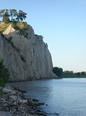
Scarborough Bluffs
Encyclopedia
Escarpment
An escarpment is a steep slope or long cliff that occurs from erosion or faulting and separates two relatively level areas of differing elevations.-Description and variants:...
in Scarborough
Scarborough, Ontario
Scarborough is a dissolved municipality within the city of Toronto, Ontario, Canada. Geographically, it comprises the eastern part of Toronto. It is bordered on the south by Lake Ontario, on the west by Victoria Park Avenue, on the north by Steeles Avenue East, and on the east by the Rouge River...
, Toronto
Toronto
Toronto is the provincial capital of Ontario and the largest city in Canada. It is located in Southern Ontario on the northwestern shore of Lake Ontario. A relatively modern city, Toronto's history dates back to the late-18th century, when its land was first purchased by the British monarchy from...
, Ontario
Ontario
Ontario is a province of Canada, located in east-central Canada. It is Canada's most populous province and second largest in total area. It is home to the nation's most populous city, Toronto, and the nation's capital, Ottawa....
, Canada. Forming much of the eastern portion of Toronto's waterfront
Toronto waterfront
The Toronto waterfront is the lakeshore of Lake Ontario in the City of Toronto, Ontario in Canada. It spans 46 kilometres between the mouth of Etobicoke Creek in the west, and the Rouge River in the East. The entire lakeshore has been significantly altered from its natural glaciated state prior to...
, it is located along the shoreline of Lake Ontario
Lake Ontario
Lake Ontario is one of the five Great Lakes of North America. It is bounded on the north and southwest by the Canadian province of Ontario, and on the south by the American state of New York. Ontario, Canada's most populous province, was named for the lake. In the Wyandot language, ontarío means...
. At its highest point, the escarpment rises 65 metres (213.3 ft) above its foot and spans a length of 14 kilometres (8.7 mi). It was first named in 1793.
The Bluffs has been described as a "geological wonder" and a unique feature in North America.
History
The bluffs were named after Scarborough, EnglandEngland
England is a country that is part of the United Kingdom. It shares land borders with Scotland to the north and Wales to the west; the Irish Sea is to the north west, the Celtic Sea to the south west, with the North Sea to the east and the English Channel to the south separating it from continental...
by Elizabeth Simcoe
Elizabeth Simcoe
Elizabeth Simcoe was an artist and diarist in colonial Canada. She was the wife of John Graves Simcoe, the first Lieutenant Governor of Upper Canada.-Biography:...
, the wife of John Graves Simcoe
John Graves Simcoe
John Graves Simcoe was a British army officer and the first Lieutenant Governor of Upper Canada from 1791–1796. Then frontier, this was modern-day southern Ontario and the watersheds of Georgian Bay and Lake Superior...
, the first lieutenant governor of Upper Canada. The bluffs along Scarborough's Lake Ontario
Lake Ontario
Lake Ontario is one of the five Great Lakes of North America. It is bounded on the north and southwest by the Canadian province of Ontario, and on the south by the American state of New York. Ontario, Canada's most populous province, was named for the lake. In the Wyandot language, ontarío means...
shores reminded her of the limestone cliffs in Scarborough, North Yorkshire, England. In her diary, she wrote, "The [eastern] shore is extremely bold, and has the appearance of chalk cliffs, but I believe they are only white sand. They appeared so well that we talked of building a summer residence there and calling it Scarborough."
A stylized version of The Bluffs appeared prominently on the flag of the former City of Scarborough
Flag of Scarborough, Ontario
The Flag of the City of Scarborough, Ontario was officially dedicated on August 19, 1969 by then-Mayor Albert Campbell at a special ceremony in Thomson Memorial Park....
.
Geology
They run 14 kilometres (8.7 mi) from the foot of Victoria Park AvenueVictoria Park Avenue
Victoria Park Avenue is a major north-south route in eastern Toronto, Ontario, Canada. It marks the border between the Old City of Toronto and Scarborough.-History:Victoria Park Avenue was originally a pioneer road for settlement of Scarborough...
in the west to the mouth of Highland Creek in the east, reaching as high as 65 metres (213.3 ft), the equivalent of seventeen storeys. However, the escarpment continues westward inland, running between Kingston Road
Kingston Road (Toronto)
Kingston Road is the southernmost major road along the eastern portion of Toronto, specifically in the districts of East York and Scarborough. Until 1998, it formed a significant portion of Highway 2...
and Queen Street East, pausing over the Don Valley, and continuing on the north side of Davenport Road. The escarpment forms the old shoreline of Glacial Lake Iroquois
Glacial Lake Iroquois
Glacial Lake Iroquois was a prehistoric proglacial lake that existed at the end of the last ice age approximately 13,000 years ago.The lake was essentially an enlargement of the present Lake Ontario that formed because the St. Lawrence River downstream from the lake was blocked by the ice sheet...
, formed after the last ice age
Quaternary glaciation
Quaternary glaciation, also known as the Pleistocene glaciation, the current ice age or simply the ice age, refers to the period of the last few million years in which permanent ice sheets were established in Antarctica and perhaps Greenland, and fluctuating ice sheets have occurred elsewhere...
, which left valuable geological records as the part of the escarpment by the lake eroded
Erosion
Erosion is when materials are removed from the surface and changed into something else. It only works by hydraulic actions and transport of solids in the natural environment, and leads to the deposition of these materials elsewhere...
. The eroded alluvial deposits
Alluvium
Alluvium is loose, unconsolidated soil or sediments, eroded, deposited, and reshaped by water in some form in a non-marine setting. Alluvium is typically made up of a variety of materials, including fine particles of silt and clay and larger particles of sand and gravel...
from the Bluffs then settled westward to form the Toronto Islands
Toronto Islands
The Toronto Islands are a chain of small islands in the city of Toronto, Ontario. Comprising the only group of islands in the western part of Lake Ontario, the Toronto Islands are located just offshore from the city centre, and provide shelter for Toronto Harbour...
.
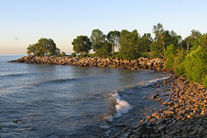
Issues
Billy Van
William Allan Van Evera, , known by the stage name Billy Van, was a Canadian comedian, actor and singer.-Biography:...
once owned is left hanging on the cliff; the cottage is deemed a safety hazard by Toronto city officials as a result. To combat erosion, boulders acting as armour rocks and trees were placed at the base. However, to place these rocks and plant trees, a beach must be created to allow trucks to access the cliff base, which would involve levelling parts of the Bluffs, such as the aforementioned Bluffer's Park. The Cathedral Bluffs, which is an impressive portion of the Bluffs, was the result of continued erosion.