
.gif)
Yoke (Lake District)
Encyclopedia
Yoke is a fell in the Lake District
in Cumbria
, England
. It has a height of 706 m (2,316 ft) and is situated in the far eastern sector
of the national park, 7 kilometres north east of the town of Ambleside
. Yoke is the southern extremity of the long ridge that runs southwards from the fell of High Street
. Yoke’s name is believed to be derived from the Old English language
word geoc which is similar to the German
word joch meaning mountain ridge.
writers as one of the most attractive fells but it is climbed frequently as part of the Kentmere Horseshoe, a 19 kilometre walk with 1,100 metres of ascent that starts and finishes in the village of Kentmere
and takes in the other fells of Kentmere Pike, Harter Fell
, Mardale Ill Bell
, Thornthwaite Crag
, Froswick
and Ill Bell
. Most common direct ascents go via the summit of the Garburn Pass (Byway open to all traffic), which can be reached either from Kentmere or Troutbeck
. At the top of the pass the walker turns northwards following a wall over initial boggy ground to reach the summit of the fell. Some repair work has been done on these southern slopes of Yoke to address the problem of footpath erosion
. The little known Rainsborrow Tarn stands on the edge of the crags. It is possible that the Roman road
between Ambleside and Penrith
came over the slopes of Yoke: old maps have shown short stretches marked “roman road” on the fell. Yoke shows signs of former quarry
ing on both its Troutbeck and Kentmere flanks.
and Morecambe Bay
, although this view is better from a cairn 100 metres to the south. There is also a good view of the higher fells to the west around Coniston, Langdale and beyond. The view north is obstructed by the higher fell of Ill Bell although the summit of High Street can just be seen. Kentmere Reservoir
can be viewed by walking 150 metres north west of the summit to the top of Star Crag.
Lake District
The Lake District, also commonly known as The Lakes or Lakeland, is a mountainous region in North West England. A popular holiday destination, it is famous not only for its lakes and its mountains but also for its associations with the early 19th century poetry and writings of William Wordsworth...
in Cumbria
Cumbria
Cumbria , is a non-metropolitan county in North West England. The county and Cumbria County Council, its local authority, came into existence in 1974 after the passage of the Local Government Act 1972. Cumbria's largest settlement and county town is Carlisle. It consists of six districts, and in...
, England
England
England is a country that is part of the United Kingdom. It shares land borders with Scotland to the north and Wales to the west; the Irish Sea is to the north west, the Celtic Sea to the south west, with the North Sea to the east and the English Channel to the south separating it from continental...
. It has a height of 706 m (2,316 ft) and is situated in the far eastern sector
Far Eastern Fells
The Far Eastern Fells are a group of hills in the English Lake District. Reaching their highest point at High Street they occupy a broad area to the east of Ullswater and Kirkstone Pass. Much quieter than the central areas of Lakeland they offer in general easier but less exciting walking as the...
of the national park, 7 kilometres north east of the town of Ambleside
Ambleside
Ambleside is a town in Cumbria, in North West England.Historically within the county of Westmorland, it is situated at the head of Windermere, England's largest lake...
. Yoke is the southern extremity of the long ridge that runs southwards from the fell of High Street
High Street (Lake District)
High Street is a fell in the English Lake District. At 828 metres , its summit is the highest point in the far eastern part of the national park. The fell is named after the Roman road which ran over the summit.-History and Naming:...
. Yoke’s name is believed to be derived from the Old English language
Old English language
Old English or Anglo-Saxon is an early form of the English language that was spoken and written by the Anglo-Saxons and their descendants in parts of what are now England and southeastern Scotland between at least the mid-5th century and the mid-12th century...
word geoc which is similar to the German
German language
German is a West Germanic language, related to and classified alongside English and Dutch. With an estimated 90 – 98 million native speakers, German is one of the world's major languages and is the most widely-spoken first language in the European Union....
word joch meaning mountain ridge.
Ascents
Yoke is not known to Lake DistrictLake District
The Lake District, also commonly known as The Lakes or Lakeland, is a mountainous region in North West England. A popular holiday destination, it is famous not only for its lakes and its mountains but also for its associations with the early 19th century poetry and writings of William Wordsworth...
writers as one of the most attractive fells but it is climbed frequently as part of the Kentmere Horseshoe, a 19 kilometre walk with 1,100 metres of ascent that starts and finishes in the village of Kentmere
Kentmere
Kentmere is a valley, village and civil parish in the Lake District National Park, a few miles from Kendal in the South Lakeland district of Cumbria, England. It is historically part of Westmorland...
and takes in the other fells of Kentmere Pike, Harter Fell
Harter Fell (Mardale)
Harter Fell is a fell in the far eastern part of the English Lake District. The summit at lies the meeting point of three ridges, and Harter Fell forms the head of three valleys: Mardale, Longsleddale and the valley of the River Kent.-Topography:...
, Mardale Ill Bell
Mardale Ill Bell
Mardale Ill Bell is a fell in the English Lake District, rising to the south west of Haweswater Reservoir. It stands on the watershed between Mardale and Kentmere and is the highpoint of the south eastern ridge of High Street, midway on its course to Harter Fell.-Topography:The head of the Kentmere...
, Thornthwaite Crag
Thornthwaite Crag
Thornthwaite Crag is a fell in the English Lake District, standing to the west of Haweswater Reservoir. It is a focal point of the Far Eastern Fells, standing at the head of several valleys.-Topography:...
, Froswick
Froswick
Froswick is a fell in the English Lake District, standing on the fine narrow ridge between the valleys of Kentmere and Troutbeck.-Topography:To the north is Thornthwaite Crag, while the adjoining fell to the south is Ill Bell. Froswick is shorter in stature than either of its neighbours and also...
and Ill Bell
Ill Bell
Ill Bell is a fell in the English Lake District, in the county of Cumbria, standing on the narrow ridge between the valleys of Kentmere and Troutbeck.-Topography:...
. Most common direct ascents go via the summit of the Garburn Pass (Byway open to all traffic), which can be reached either from Kentmere or Troutbeck
Troutbeck, South Lakeland
Troutbeck is a village in South Lakeland district in Cumbria. It is north of Windermere town, to the west of the A592 road. It is a conservation area and includes the National Trust property of Townend.-Village Amenities:...
. At the top of the pass the walker turns northwards following a wall over initial boggy ground to reach the summit of the fell. Some repair work has been done on these southern slopes of Yoke to address the problem of footpath erosion
Topography
Yoke’s most interesting topographic feature is Rainsborrow Crag on the Kentmere side of the fell. This is a 300 metre precipice which falls away to the valley floor; the crags have attracted top rock climbersClimbing
Climbing is the activity of using one's hands and feet to ascend a steep object. It is done both for recreation and professionally, as part of activities such as maintenance of a structure, or military operations.Climbing activities include:* Bouldering: Ascending boulders or small...
. The little known Rainsborrow Tarn stands on the edge of the crags. It is possible that the Roman road
Roman road
The Roman roads were a vital part of the development of the Roman state, from about 500 BC through the expansion during the Roman Republic and the Roman Empire. Roman roads enabled the Romans to move armies and trade goods and to communicate. The Roman road system spanned more than 400,000 km...
between Ambleside and Penrith
Penrith, Cumbria
Penrith was an urban district between 1894 and 1974, when it was merged into Eden District.The authority's area was coterminous with the civil parish of Penrith although when the council was abolished Penrith became an unparished area....
came over the slopes of Yoke: old maps have shown short stretches marked “roman road” on the fell. Yoke shows signs of former quarry
Quarry
A quarry is a type of open-pit mine from which rock or minerals are extracted. Quarries are generally used for extracting building materials, such as dimension stone, construction aggregate, riprap, sand, and gravel. They are often collocated with concrete and asphalt plants due to the requirement...
ing on both its Troutbeck and Kentmere flanks.
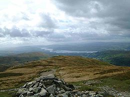
View
The view from the top of the fell takes in good views of WindermereWindermere (lake)
Windermere is the largest natural lake in England. It is a ribbon lake formed in a glacial trough after the retreat of ice at the start of the current interglacial. It has been one of the country’s most popular places for holidays and summer homes since the arrival of the Kendal and Windermere...
and Morecambe Bay
Morecambe Bay
Morecambe Bay is a large bay in northwest England, nearly due east of the Isle of Man and just to the south of the Lake District National Park. It is the largest expanse of intertidal mudflats and sand in the United Kingdom, covering a total area of 310 km².-Natural features:The rivers Leven,...
, although this view is better from a cairn 100 metres to the south. There is also a good view of the higher fells to the west around Coniston, Langdale and beyond. The view north is obstructed by the higher fell of Ill Bell although the summit of High Street can just be seen. Kentmere Reservoir
Kentmere Reservoir
Kentmere Reservoir is a water storage facility situated in the Kentmere valley in the county of Cumbria, England. It is located 10.5 km north-northeast of the town of Windermere...
can be viewed by walking 150 metres north west of the summit to the top of Star Crag.
External references
- A Pictorial Guide to the Lakeland Fells, The Far Eastern Fells, Alfred Wainwright ISBN 0-7112-2455-2
- Complete Lakeland Fells, Bill Birkett, ISBN 0-00-713629-3