
Stony Cove Pike
Encyclopedia
Stony Cove Pike is a fell
in the Far Eastern part
of the English
Lake District
. It stands on the other side of the Kirkstone Pass
from Red Screes
, and is on the end of a ridge coming down from High Street
. It is separated from its neighbours by the deep col
of Threshthwaite Mouth, so is a Marilyn
– the sixteenth highest in the Lake District.
maps name the main summit as 'Stony Cove Pike', the second top to the west as 'Caudale Moor' and 'John Bell's Banner' is reserved for the south west ridge descending to St Raven's Edge. Alfred Wainwright
in his Pictorial Guide to the Lakeland Fells
uses Caudale Moor for the fell as a whole, John Bell's Banner as an alternative to this and Stony Cove Pike as a name for the (main) summit. Bill Birkett prefers the Ordnance Survey scheme, but with John Bell's Banner as a second name for the subsidiary top.
s leaving the summit
area. The main summit sprouts four to the points of the compass. Eastward is the rocky descent to Threshwaite Mouth, followed by an equally steep climb to Thornthwaite Crag
. Northward is the grassy ridge to Hartsop Dodd
and westward the plateau narrows slightly toward the second top of Caudale Moor/ John Bell's Banner (2477 ft). To the south of the main top a short spur juts out into the head of the Trout Beck valley, before falling steeps over Doup Crag.
From the lower top the narrow descending ridge of Rough Edge drops north west toward Caudale Bridge. The extensive Caudale Quarry is hollowed out about halfway down the edge, reached by what was once believed to be the steepest working track in Lakeland.. There is also evidence of deeper mining here.
A broad ridge also descends south from the Caudale Moor top. This passes over Pike How before dividing around the head of Woundale. The south western branch descends down St Raven's Edge to the Kirkstone Pass
road at Woundale Raise, before climbing again to Wansfell
. The south eastern spur is much shorter, dropping over Hart Crag and Great Knott into the Troutbeck valley.
s between the two tops. Walls follow the ridges to Hartsop Dodd, St Raven's Edge and Threshthwaite Mouth, making navigation of the complex ridge system easier. Both tops have cairn
s and there is a further cairn topped by a wooden cross to the south west of Caudale Moor. This is named Mark Atkinson's monument by Wainwright.. Despite the somewhat dreary nature of the top, considerable areas of crag surround the plateau. Caudale Head between the northern ridges is one, and more crag lies north and south of Threshthwaite Mouth at the heads of Pasture and Trout Becks. The flatness of the top leads to a somewhat restricted view of the surrounding fells, although all of the major groups are in sight from the summit.
is to make a small circuit from the Patterdale
valley, going up the steep north ridge to the top, then across Threshthwaite Mouth and up to Thornthwaite Crag. From there the circuit is completed via Thornthwaite Crag's north ridge, known as Gray Crag
.
The southern ridge from Wansfell and Ambleside
provides a longer alternative route of ascent. The quickest way up is from the top of Kirkstone Pass via St Raven's Edge: this route was described by Alfred Wainwright as the "dullest way up". ..
Fell
“Fell” is a word used to refer to mountains, or certain types of mountainous landscape, in Scandinavia, the Isle of Man, and parts of northern England.- Etymology :...
in the Far Eastern part
Far Eastern Fells
The Far Eastern Fells are a group of hills in the English Lake District. Reaching their highest point at High Street they occupy a broad area to the east of Ullswater and Kirkstone Pass. Much quieter than the central areas of Lakeland they offer in general easier but less exciting walking as the...
of the English
England
England is a country that is part of the United Kingdom. It shares land borders with Scotland to the north and Wales to the west; the Irish Sea is to the north west, the Celtic Sea to the south west, with the North Sea to the east and the English Channel to the south separating it from continental...
Lake District
Lake District
The Lake District, also commonly known as The Lakes or Lakeland, is a mountainous region in North West England. A popular holiday destination, it is famous not only for its lakes and its mountains but also for its associations with the early 19th century poetry and writings of William Wordsworth...
. It stands on the other side of the Kirkstone Pass
Kirkstone Pass
Kirkstone Pass is a mountain pass in the English Lake District, in the county of Cumbria. It is at an altitude of .This is the Lake District's highest pass that is open to motor traffic and it connects Ambleside in the Rothay Valley to Patterdale in the Ullswater Valley - the A592 road. In places,...
from Red Screes
Red Screes
Red Screes is a fell in the English Lake District, situated between the villages of Patterdale and Ambleside. It is an outlier of the Fairfield group in the Eastern Fells, but is separated from its neighbours by low cols...
, and is on the end of a ridge coming down from High Street
High Street (Lake District)
High Street is a fell in the English Lake District. At 828 metres , its summit is the highest point in the far eastern part of the national park. The fell is named after the Roman road which ran over the summit.-History and Naming:...
. It is separated from its neighbours by the deep col
Mountain pass
A mountain pass is a route through a mountain range or over a ridge. If following the lowest possible route, a pass is locally the highest point on that route...
of Threshthwaite Mouth, so is a Marilyn
Marilyn (hill)
A Marilyn is a mountain or hill in the United Kingdom, Republic of Ireland or Isle of Man with a relative height of at least 150 metres , regardless of absolute height or other merit...
– the sixteenth highest in the Lake District.
Name
There is considerable variation over use of the alternative names for the fell. The Ordnance SurveyOrdnance Survey
Ordnance Survey , an executive agency and non-ministerial government department of the Government of the United Kingdom, is the national mapping agency for Great Britain, producing maps of Great Britain , and one of the world's largest producers of maps.The name reflects its creation together with...
maps name the main summit as 'Stony Cove Pike', the second top to the west as 'Caudale Moor' and 'John Bell's Banner' is reserved for the south west ridge descending to St Raven's Edge. Alfred Wainwright
Alfred Wainwright
Alfred Wainwright MBE was a British fellwalker, guidebook author and illustrator. His seven-volume Pictorial Guide to the Lakeland Fells, published between 1955 and 1966 and consisting entirely of reproductions of his manuscript, has become the standard reference work to 214 of the fells of the...
in his Pictorial Guide to the Lakeland Fells
Pictorial Guide to the Lakeland Fells
A Pictorial Guide to the Lakeland Fells is a series of seven books by A. Wainwright, detailing the fells of the Lake District in northwest England...
uses Caudale Moor for the fell as a whole, John Bell's Banner as an alternative to this and Stony Cove Pike as a name for the (main) summit. Bill Birkett prefers the Ordnance Survey scheme, but with John Bell's Banner as a second name for the subsidiary top.
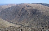
Topography
The fell is wide and sprawling, with six ridgeRidge
A ridge is a geological feature consisting of a chain of mountains or hills that form a continuous elevated crest for some distance. Ridges are usually termed hills or mountains as well, depending on size. There are several main types of ridges:...
s leaving the summit
Summit (topography)
In topography, a summit is a point on a surface that is higher in elevation than all points immediately adjacent to it. Mathematically, a summit is a local maximum in elevation...
area. The main summit sprouts four to the points of the compass. Eastward is the rocky descent to Threshwaite Mouth, followed by an equally steep climb to Thornthwaite Crag
Thornthwaite Crag
Thornthwaite Crag is a fell in the English Lake District, standing to the west of Haweswater Reservoir. It is a focal point of the Far Eastern Fells, standing at the head of several valleys.-Topography:...
. Northward is the grassy ridge to Hartsop Dodd
Hartsop Dodd
Hartsop Dodd is a fell in the English Lake District, standing to the south east of Brothers Water. It is a subsidiary top on the north ridge of Caudale Moor, but was given separate fell status by Wainwright in his Pictorial Guide to the Lakeland Fells...
and westward the plateau narrows slightly toward the second top of Caudale Moor/ John Bell's Banner (2477 ft). To the south of the main top a short spur juts out into the head of the Trout Beck valley, before falling steeps over Doup Crag.
From the lower top the narrow descending ridge of Rough Edge drops north west toward Caudale Bridge. The extensive Caudale Quarry is hollowed out about halfway down the edge, reached by what was once believed to be the steepest working track in Lakeland.. There is also evidence of deeper mining here.
A broad ridge also descends south from the Caudale Moor top. This passes over Pike How before dividing around the head of Woundale. The south western branch descends down St Raven's Edge to the Kirkstone Pass
Kirkstone Pass
Kirkstone Pass is a mountain pass in the English Lake District, in the county of Cumbria. It is at an altitude of .This is the Lake District's highest pass that is open to motor traffic and it connects Ambleside in the Rothay Valley to Patterdale in the Ullswater Valley - the A592 road. In places,...
road at Woundale Raise, before climbing again to Wansfell
Wansfell
Wansfell is a fell in English Lake District it is situated 2.5 kilometres east of the town of Ambleside. The fell is part of the long southern ridge of Caudale Moor and occupies the swathe of territory between Ambleside and the Troutbeck valley.-Topography:...
. The south eastern spur is much shorter, dropping over Hart Crag and Great Knott into the Troutbeck valley.
Summit and view
The summit area is grassy, with a number of small tarnTarn (lake)
A tarn is a mountain lake or pool, formed in a cirque excavated by a glacier. A moraine may form a natural dam below a tarn. A corrie may be called a cirque.The word is derived from the Old Norse word tjörn meaning pond...
s between the two tops. Walls follow the ridges to Hartsop Dodd, St Raven's Edge and Threshthwaite Mouth, making navigation of the complex ridge system easier. Both tops have cairn
Cairn
Cairn is a term used mainly in the English-speaking world for a man-made pile of stones. It comes from the or . Cairns are found all over the world in uplands, on moorland, on mountaintops, near waterways and on sea cliffs, and also in barren desert and tundra areas...
s and there is a further cairn topped by a wooden cross to the south west of Caudale Moor. This is named Mark Atkinson's monument by Wainwright.. Despite the somewhat dreary nature of the top, considerable areas of crag surround the plateau. Caudale Head between the northern ridges is one, and more crag lies north and south of Threshthwaite Mouth at the heads of Pasture and Trout Becks. The flatness of the top leads to a somewhat restricted view of the surrounding fells, although all of the major groups are in sight from the summit.
Ascents
The most common way of ascentClimb
thumb|right|An [[Embraer ERJ 145]] climbingIn aviation, the term climb refers both to the actual operation of increasing the altitude of an aircraft and to the logical phase of a typical flight following take-off and preceding the cruise, during which an increase in altitude to a predetermined...
is to make a small circuit from the Patterdale
Patterdale
Patterdale is a small village and civil parish in the eastern part of the English Lake District in the Eden District of Cumbria, and the long valley in which they are found, also called the Ullswater Valley....
valley, going up the steep north ridge to the top, then across Threshthwaite Mouth and up to Thornthwaite Crag. From there the circuit is completed via Thornthwaite Crag's north ridge, known as Gray Crag
Gray Crag
-Topography:The fell reaches a height of 699 metres at the northern end of its summit ridge and this is the accepted highest point which gives the best views, although there is a spot height of 710 metres less than a kilometre to the south. Both tops have small cairns set on grass...
.
The southern ridge from Wansfell and Ambleside
Ambleside
Ambleside is a town in Cumbria, in North West England.Historically within the county of Westmorland, it is situated at the head of Windermere, England's largest lake...
provides a longer alternative route of ascent. The quickest way up is from the top of Kirkstone Pass via St Raven's Edge: this route was described by Alfred Wainwright as the "dullest way up". ..