
Angletarn Pikes
Encyclopedia
Angletarn Pikes, is a fell
in the English
Lake District
, near the village of Patterdale
. Its most notable feature is the summit tarn
from which it derives its name.
catchment, a system of valleys draining north into Ullswater
. The adjacent fells on this ridge are Place Fell
to the north and Brock Crags
to the south. Beda Fell
, a subsidiary ridge, also juts out into Martindale from Angletarn Pikes. This separates the heads of Boredale
and Bannerdale.
The western side above Goldrill Beck is steep and includes the faces of Dubhow and Fall Crags. The long eastern flank above Bannerdale is also pock-marked with crags, Heck Crag being the principal feature. The narrow north eastern slopes above Boredale, although steep, are less rocky and are cut by the upper ravine of Freeze Beck.
North from the summit a long ridge drops over Stony Rigg (1,640 ft) to the walkers crossroads of Boredale Hause. From here paths run down to Hartsop, Patterdale and Boredale, while a further bridleway cuts across Beda Fell to Bannerdale. Boredale Hause carries the tiny ruin of a building named 'Chapel in the Hause' on OS
maps. A mountain pass at 1,300 ft seems a curious place to construct a church. From the Hause a good path carries on northwards up Steel Edge to Place Fell.
The north east ridge to Beda Fell is also well defined, a fair path traversing a series of rocky knolls before the final rise to the summit, named Beda Head.
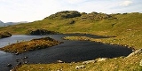
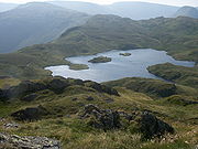
Southward from Angletarn Pikes is Angle Tarn itself. This indented waterbody is about a quarter of a mile long with an island in the middle and forms a picturesque foreground for views of the Pikes. The tarn sits in a hollow on the centre of the ridge, issuing westwards through a break in the parapet via the ravine of Angletarn Beck. The ridge proper runs to the east of the tarn above the Bannerdale face, rising again to the unnamed 1,870 ft top above Satura Crag. This overtops the summit of Brock Crags, but was made subservient to it by Wainwright
in his Pictorial Guide to the Lakeland Fells
.
range to the spine of the Far Eastern Fells
across Martindale.
, ascending via the Beda Fell ridge or Angle Tarn. The route from Patterdale is often undertaken as the first section of the ascent of High Street
.
Fell
“Fell” is a word used to refer to mountains, or certain types of mountainous landscape, in Scandinavia, the Isle of Man, and parts of northern England.- Etymology :...
in the English
England
England is a country that is part of the United Kingdom. It shares land borders with Scotland to the north and Wales to the west; the Irish Sea is to the north west, the Celtic Sea to the south west, with the North Sea to the east and the English Channel to the south separating it from continental...
Lake District
Lake District
The Lake District, also commonly known as The Lakes or Lakeland, is a mountainous region in North West England. A popular holiday destination, it is famous not only for its lakes and its mountains but also for its associations with the early 19th century poetry and writings of William Wordsworth...
, near the village of Patterdale
Patterdale
Patterdale is a small village and civil parish in the eastern part of the English Lake District in the Eden District of Cumbria, and the long valley in which they are found, also called the Ullswater Valley....
. Its most notable feature is the summit tarn
Tarn (lake)
A tarn is a mountain lake or pool, formed in a cirque excavated by a glacier. A moraine may form a natural dam below a tarn. A corrie may be called a cirque.The word is derived from the Old Norse word tjörn meaning pond...
from which it derives its name.
Topography
Angletarn Pikes stands on the western arm of the long horseshoe ridge which surrounds the MartindaleMartindale, Cumbria
Martindale is a valley and civil parish in Cumbria, England, situated within the Lake District National Park between the lakes of Ullswater and Haweswater...
catchment, a system of valleys draining north into Ullswater
Ullswater
Ullswater is the second largest lake in the English Lake District, being approximately nine miles long and 0.75 miles wide with a maximum depth of slightly more than ....
. The adjacent fells on this ridge are Place Fell
Place Fell
Place Fell is a hill in the English Lake District. It stands at the corner of the upper and middle reaches of Ullswater, with steep western flanks overlooking the villages of Glenridding and Patterdale.-Topography:...
to the north and Brock Crags
Brock Crags
Brock Crags is a fell in the English Lake District, standing above Hartsop in the Far Eastern Fells. It forms part of the perimeter of Martindale, lying on the long ridge from Rampsgill Head to Place Fell.-Location of summit:...
to the south. Beda Fell
Beda Fell
Beda Fell is a fell in the English Lake District, situated to the south of Ullswater. It divides the valleys of Boredale and Bannerdale within the Martindale system.-Topography:...
, a subsidiary ridge, also juts out into Martindale from Angletarn Pikes. This separates the heads of Boredale
Boredale
Boredale sometimes known as Boardale, is a valley in Cumbria, England, it is situated within the Lake District National Park. The valley is close to the eastern shore of Ullswater and lies between the hills of Place Fell to the west and Beda Fell to the east.Boredale runs in a northerly direction...
and Bannerdale.
The western side above Goldrill Beck is steep and includes the faces of Dubhow and Fall Crags. The long eastern flank above Bannerdale is also pock-marked with crags, Heck Crag being the principal feature. The narrow north eastern slopes above Boredale, although steep, are less rocky and are cut by the upper ravine of Freeze Beck.
North from the summit a long ridge drops over Stony Rigg (1,640 ft) to the walkers crossroads of Boredale Hause. From here paths run down to Hartsop, Patterdale and Boredale, while a further bridleway cuts across Beda Fell to Bannerdale. Boredale Hause carries the tiny ruin of a building named 'Chapel in the Hause' on OS
Ordnance Survey
Ordnance Survey , an executive agency and non-ministerial government department of the Government of the United Kingdom, is the national mapping agency for Great Britain, producing maps of Great Britain , and one of the world's largest producers of maps.The name reflects its creation together with...
maps. A mountain pass at 1,300 ft seems a curious place to construct a church. From the Hause a good path carries on northwards up Steel Edge to Place Fell.
The north east ridge to Beda Fell is also well defined, a fair path traversing a series of rocky knolls before the final rise to the summit, named Beda Head.
Southward from Angletarn Pikes is Angle Tarn itself. This indented waterbody is about a quarter of a mile long with an island in the middle and forms a picturesque foreground for views of the Pikes. The tarn sits in a hollow on the centre of the ridge, issuing westwards through a break in the parapet via the ravine of Angletarn Beck. The ridge proper runs to the east of the tarn above the Bannerdale face, rising again to the unnamed 1,870 ft top above Satura Crag. This overtops the summit of Brock Crags, but was made subservient to it by Wainwright
Alfred Wainwright
Alfred Wainwright MBE was a British fellwalker, guidebook author and illustrator. His seven-volume Pictorial Guide to the Lakeland Fells, published between 1955 and 1966 and consisting entirely of reproductions of his manuscript, has become the standard reference work to 214 of the fells of the...
in his Pictorial Guide to the Lakeland Fells
Pictorial Guide to the Lakeland Fells
A Pictorial Guide to the Lakeland Fells is a series of seven books by A. Wainwright, detailing the fells of the Lake District in northwest England...
.
Summit and View
Angletarn Pikes takes its plural from the two rocky towers at the summit, separated by perhaps 200 yards of peaty bog. These resemble the Langdale Pikes in miniature and can only be ascended by scrambling. The northern top is the true summit, the other being some six feet lower. The southern top is compensated by a clear view of Angle Tarn, described by Wainwright as among the best of Lakeland tarns.. The wider view stretches from the HelvellynHelvellyn
Helvellyn is a mountain in the English Lake District, the apex of the Eastern Fells. At above sea level, it is the third highest peak in both the Lake District and England...
range to the spine of the Far Eastern Fells
Far Eastern Fells
The Far Eastern Fells are a group of hills in the English Lake District. Reaching their highest point at High Street they occupy a broad area to the east of Ullswater and Kirkstone Pass. Much quieter than the central areas of Lakeland they offer in general easier but less exciting walking as the...
across Martindale.
Ascents
The fell can be climbed via Boredale Hause, making Patterdale, Hartsop and Boredale Head all possible starting points. An alternative is to climb from Martindale Old ChurchSt Martin’s Church, Martindale
St Martin’s Church, Martindale is located in the valley of Martindale in Cumbria, England. It is often referred to as the “Old Church” to avoid confusion with the nearby St Peter‘s Church which is situated half a mile down the valley. The church is dedicated to Saint Martin of Tours. It is now only...
, ascending via the Beda Fell ridge or Angle Tarn. The route from Patterdale is often undertaken as the first section of the ascent of High Street
High Street (Lake District)
High Street is a fell in the English Lake District. At 828 metres , its summit is the highest point in the far eastern part of the national park. The fell is named after the Roman road which ran over the summit.-History and Naming:...
.