
Rest Dodd
Encyclopedia
Rest Dodd is a fell
in the English
Lake District
. It is situated in the quieter far eastern region
of the national park
and reaches a height of 696 metres (2,283 feet). Rest Dodd is a fell that is often by-passed by walkers as they travel the busy footpath between Ullswater
and Haweswater
either to climb the more significant fell of High Street
or strive to complete Alfred Wainwright
’s Coast to Coast Walk
. Indeed Wainwright describes Rest Dodd as “A fell of little interest although the east flank falls spectacularly in fans of colourful scree”. The fell is usually climbed in conjunction with other nearby "Wainwright" fells such as The Nab
, Brock Crags
and Angletarn Pikes
.
catchment, an extensive valley system emptying north into Ullswater
. South east of Rest Dodd is The Knott
and in the opposite direction is Brock Crags. A subsidiary ridge juts out north from Rest Dodd, ending at The Nab. This fell separates the heads of the Martindale valleys of Bannerdale and Rampsgill. A much shorter rocky spur also runs north west from Rest Dodd, divided from the Nab by Yewgrove Gill. The southern flank of the fell is formed by Hayeswater Gill.
Rest Dodd appears as a high, rounded dome from most directions, the upper slopes being clad in rough grass. Below about 1,500 ft all of the faces are steep and rough, with some outcropping on the Martindale flanks. The ridge connecting to The Knott is broad topped and marshy, whilst that connecting to Brock Crags crosses a series of rocky outcrops as it narrows above Satura Crag. The way to the Nab, once the boundary wall of the deer forest is passed, is crossed by extensive peat hags. Many of these are deeper than the height of a man and add considerably to the time required.
where there are two possible starting points: the village of Hartsop gives the most advantageous start being just two miles from the fell summit but it is a tough climb from Hayeswater Gill to join the main path from Patterdale village to Haweswater. The other route is longer (3.5 miles) and starts in Patterdale village and utilises the main path over Boardale hause and past Angle Tarn before following an old stone wall which leads unerringly to Rest Dodd’s summit.
range to the west as well as a spectacular view of the Ramps Gill valley to the north.
Fell
“Fell” is a word used to refer to mountains, or certain types of mountainous landscape, in Scandinavia, the Isle of Man, and parts of northern England.- Etymology :...
in the English
England
England is a country that is part of the United Kingdom. It shares land borders with Scotland to the north and Wales to the west; the Irish Sea is to the north west, the Celtic Sea to the south west, with the North Sea to the east and the English Channel to the south separating it from continental...
Lake District
Lake District
The Lake District, also commonly known as The Lakes or Lakeland, is a mountainous region in North West England. A popular holiday destination, it is famous not only for its lakes and its mountains but also for its associations with the early 19th century poetry and writings of William Wordsworth...
. It is situated in the quieter far eastern region
Far Eastern Fells
The Far Eastern Fells are a group of hills in the English Lake District. Reaching their highest point at High Street they occupy a broad area to the east of Ullswater and Kirkstone Pass. Much quieter than the central areas of Lakeland they offer in general easier but less exciting walking as the...
of the national park
National park
A national park is a reserve of natural, semi-natural, or developed land that a sovereign state declares or owns. Although individual nations designate their own national parks differently A national park is a reserve of natural, semi-natural, or developed land that a sovereign state declares or...
and reaches a height of 696 metres (2,283 feet). Rest Dodd is a fell that is often by-passed by walkers as they travel the busy footpath between Ullswater
Ullswater
Ullswater is the second largest lake in the English Lake District, being approximately nine miles long and 0.75 miles wide with a maximum depth of slightly more than ....
and Haweswater
Haweswater Reservoir
Haweswater is a reservoir in the English Lake District, built in the valley of Mardale in the county of Cumbria. The controversial construction of the Haweswater dam started in 1929, after Parliament passed an Act giving the Manchester Corporation permission to build the reservoir to supply water...
either to climb the more significant fell of High Street
High Street (Lake District)
High Street is a fell in the English Lake District. At 828 metres , its summit is the highest point in the far eastern part of the national park. The fell is named after the Roman road which ran over the summit.-History and Naming:...
or strive to complete Alfred Wainwright
Alfred Wainwright
Alfred Wainwright MBE was a British fellwalker, guidebook author and illustrator. His seven-volume Pictorial Guide to the Lakeland Fells, published between 1955 and 1966 and consisting entirely of reproductions of his manuscript, has become the standard reference work to 214 of the fells of the...
’s Coast to Coast Walk
Coast to Coast Walk
The Coast to Coast Walk is a 192-mile unofficial and mostly unsignposted long distance footpath in Northern England...
. Indeed Wainwright describes Rest Dodd as “A fell of little interest although the east flank falls spectacularly in fans of colourful scree”. The fell is usually climbed in conjunction with other nearby "Wainwright" fells such as The Nab
The Nab
The Nab is a fell in the English Lake District. It has a moderate height of 576 metres , and lies in the quieter eastern high ground between Ullswater and Haweswater Reservoir...
, Brock Crags
Brock Crags
Brock Crags is a fell in the English Lake District, standing above Hartsop in the Far Eastern Fells. It forms part of the perimeter of Martindale, lying on the long ridge from Rampsgill Head to Place Fell.-Location of summit:...
and Angletarn Pikes
Angletarn Pikes
Angletarn Pikes, is a fell in the English Lake District, near the village of Patterdale. Its most notable feature is the summit tarn from which it derives its name.-Topography:...
.
Topography
Rest Dodd stands on the long ridge forming the boundary of the MartindaleMartindale, Cumbria
Martindale is a valley and civil parish in Cumbria, England, situated within the Lake District National Park between the lakes of Ullswater and Haweswater...
catchment, an extensive valley system emptying north into Ullswater
Ullswater
Ullswater is the second largest lake in the English Lake District, being approximately nine miles long and 0.75 miles wide with a maximum depth of slightly more than ....
. South east of Rest Dodd is The Knott
The Knott
The Knott is a fell in the English Lake District, standing above Hayeswater in the Far Eastern Fells. It is an outlier of Rampsgill Head, being the high point of the ridge from there to Rest Dodd.-Topography:...
and in the opposite direction is Brock Crags. A subsidiary ridge juts out north from Rest Dodd, ending at The Nab. This fell separates the heads of the Martindale valleys of Bannerdale and Rampsgill. A much shorter rocky spur also runs north west from Rest Dodd, divided from the Nab by Yewgrove Gill. The southern flank of the fell is formed by Hayeswater Gill.
Rest Dodd appears as a high, rounded dome from most directions, the upper slopes being clad in rough grass. Below about 1,500 ft all of the faces are steep and rough, with some outcropping on the Martindale flanks. The ridge connecting to The Knott is broad topped and marshy, whilst that connecting to Brock Crags crosses a series of rocky outcrops as it narrows above Satura Crag. The way to the Nab, once the boundary wall of the deer forest is passed, is crossed by extensive peat hags. Many of these are deeper than the height of a man and add considerably to the time required.
Ascents
The ascent of Rest Dodd is usually started from the valley of PatterdalePatterdale
Patterdale is a small village and civil parish in the eastern part of the English Lake District in the Eden District of Cumbria, and the long valley in which they are found, also called the Ullswater Valley....
where there are two possible starting points: the village of Hartsop gives the most advantageous start being just two miles from the fell summit but it is a tough climb from Hayeswater Gill to join the main path from Patterdale village to Haweswater. The other route is longer (3.5 miles) and starts in Patterdale village and utilises the main path over Boardale hause and past Angle Tarn before following an old stone wall which leads unerringly to Rest Dodd’s summit.
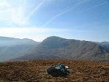
Summit and view
The summit of the fell has a substantial cairn due to the proximity of quite a few old stone walls and gives a good full length view of the HelvellynHelvellyn
Helvellyn is a mountain in the English Lake District, the apex of the Eastern Fells. At above sea level, it is the third highest peak in both the Lake District and England...
range to the west as well as a spectacular view of the Ramps Gill valley to the north.