
Hallin Fell
Encyclopedia
Hallin Fell is a hill in the English
Lake District
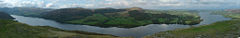
surrounded on three sides by Ullswater
.
, but the depression at The Coombs is so profound that Hallin Fell appears totally independent in almost any view. This is born out by its status as a Marilyn
, despite being diminutive amongst Lakeland fell
s.
Hallin Fell stands like a plug in the outlet of the Martindale
valley system. The outflows of Rampsgill, Bannerdale and Boredale
are deflected west around the fell, eventually finding the shore of Ullswater at Sandwick. Fusedale and the little valley above Howtown drain around the east of the fell to meet the Lake at Howtown Wyke. The southern boundaries of the fell are therefore easily defined by these watercourses and the Howtown to Sandwick road with its ferocious hairpin climb to The Coombs.
The fell is circular in plan with smooth slopes to the south and west. Wainwright
famously claimed that the southern side could be "ascended comfortably in bare feet". There is rougher ground on the other sides and Hallin Fell's northernmost extremity — Geordie's Crag — projects into the lake, separating Ullswater's middle and lower reaches.
, and there are many other small cairns at other vantage points. Like many shorter hills in mountainous areas, the views from the summit are excellent, and Hallin Fell commands views across Martindale Common, High Street
, Helvellyn
, Blencathra
and Ullswater
.

at the summit is short and easy, there are also multiple paths up from St Peter's church
at the hause and from Howtown
hamlet. Around the northern side of the fell is part of the popular lakeside walk from Howtown to Patterdale. This route, mainly in wooded surroundings and with some gentle scrambling over outcrops, can be combined with a trip on the Ullswater steamer to provide a fine low-level excursion.
England
England is a country that is part of the United Kingdom. It shares land borders with Scotland to the north and Wales to the west; the Irish Sea is to the north west, the Celtic Sea to the south west, with the North Sea to the east and the English Channel to the south separating it from continental...
Lake District
Lake District
The Lake District, also commonly known as The Lakes or Lakeland, is a mountainous region in North West England. A popular holiday destination, it is famous not only for its lakes and its mountains but also for its associations with the early 19th century poetry and writings of William Wordsworth...
surrounded on three sides by Ullswater
Ullswater
Ullswater is the second largest lake in the English Lake District, being approximately nine miles long and 0.75 miles wide with a maximum depth of slightly more than ....
.
Topography
The fell is a continuation of the ridge leading down from Steel KnottsSteel Knotts
Steel Knotts is a fell in the English Lake District, near to Ullswater in the Far Eastern Fells. It stands between the valleys of Fusedale and Martindale on a ridge running north-south.-Topography:...
, but the depression at The Coombs is so profound that Hallin Fell appears totally independent in almost any view. This is born out by its status as a Marilyn
Marilyn (hill)
A Marilyn is a mountain or hill in the United Kingdom, Republic of Ireland or Isle of Man with a relative height of at least 150 metres , regardless of absolute height or other merit...
, despite being diminutive amongst Lakeland fell
Fell
“Fell” is a word used to refer to mountains, or certain types of mountainous landscape, in Scandinavia, the Isle of Man, and parts of northern England.- Etymology :...
s.
Hallin Fell stands like a plug in the outlet of the Martindale
Martindale, Cumbria
Martindale is a valley and civil parish in Cumbria, England, situated within the Lake District National Park between the lakes of Ullswater and Haweswater...
valley system. The outflows of Rampsgill, Bannerdale and Boredale
Boredale
Boredale sometimes known as Boardale, is a valley in Cumbria, England, it is situated within the Lake District National Park. The valley is close to the eastern shore of Ullswater and lies between the hills of Place Fell to the west and Beda Fell to the east.Boredale runs in a northerly direction...
are deflected west around the fell, eventually finding the shore of Ullswater at Sandwick. Fusedale and the little valley above Howtown drain around the east of the fell to meet the Lake at Howtown Wyke. The southern boundaries of the fell are therefore easily defined by these watercourses and the Howtown to Sandwick road with its ferocious hairpin climb to The Coombs.
The fell is circular in plan with smooth slopes to the south and west. Wainwright
Alfred Wainwright
Alfred Wainwright MBE was a British fellwalker, guidebook author and illustrator. His seven-volume Pictorial Guide to the Lakeland Fells, published between 1955 and 1966 and consisting entirely of reproductions of his manuscript, has become the standard reference work to 214 of the fells of the...
famously claimed that the southern side could be "ascended comfortably in bare feet". There is rougher ground on the other sides and Hallin Fell's northernmost extremity — Geordie's Crag — projects into the lake, separating Ullswater's middle and lower reaches.
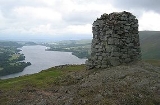
Summit and view
The top is grassy with a number of small knolls and some outcropping rock. The highest point has an imposing square sectioned columnar cairnCairn
Cairn is a term used mainly in the English-speaking world for a man-made pile of stones. It comes from the or . Cairns are found all over the world in uplands, on moorland, on mountaintops, near waterways and on sea cliffs, and also in barren desert and tundra areas...
, and there are many other small cairns at other vantage points. Like many shorter hills in mountainous areas, the views from the summit are excellent, and Hallin Fell commands views across Martindale Common, High Street
High Street (Lake District)
High Street is a fell in the English Lake District. At 828 metres , its summit is the highest point in the far eastern part of the national park. The fell is named after the Roman road which ran over the summit.-History and Naming:...
, Helvellyn
Helvellyn
Helvellyn is a mountain in the English Lake District, the apex of the Eastern Fells. At above sea level, it is the third highest peak in both the Lake District and England...
, Blencathra
Blencathra
Blencathra, also known as Saddleback, is one of the most northerly mountains in the English Lake District. It has six separate fell tops, of which the highest is the Hallsfell Top.-Name:...
and Ullswater
Ullswater
Ullswater is the second largest lake in the English Lake District, being approximately nine miles long and 0.75 miles wide with a maximum depth of slightly more than ....
.
Ascents and lakeside walk
The climb from Howtown to the obeliskObelisk
An obelisk is a tall, four-sided, narrow tapering monument which ends in a pyramid-like shape at the top, and is said to resemble a petrified ray of the sun-disk. A pair of obelisks usually stood in front of a pylon...
at the summit is short and easy, there are also multiple paths up from St Peter's church
St Peter’s Church, Martindale
St Peter’s Church, Martindale is situated in the valley of Martindale in Cumbria, England. The church is located at the top of the hause on the minor road between Martindale and Howtown...
at the hause and from Howtown
Howtown
Howtown is a hamlet in Cumbria, England, situated at a small harbour on the east shore of Ullswater in the Lake District.Howtown is about three and a half miles from Pooley Bridge and is best reached by water...
hamlet. Around the northern side of the fell is part of the popular lakeside walk from Howtown to Patterdale. This route, mainly in wooded surroundings and with some gentle scrambling over outcrops, can be combined with a trip on the Ullswater steamer to provide a fine low-level excursion.
External links
- Hallin Fell is at coordinates 54.570570°N 2.876354°W