

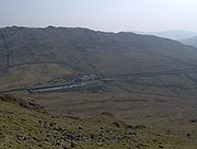
A592 road
Encyclopedia
England
England is a country that is part of the United Kingdom. It shares land borders with Scotland to the north and Wales to the west; the Irish Sea is to the north west, the Celtic Sea to the south west, with the North Sea to the east and the English Channel to the south separating it from continental...
Lake District
Lake District
The Lake District, also commonly known as The Lakes or Lakeland, is a mountainous region in North West England. A popular holiday destination, it is famous not only for its lakes and its mountains but also for its associations with the early 19th century poetry and writings of William Wordsworth...
.
The road connects Penrith
Penrith, Cumbria
Penrith was an urban district between 1894 and 1974, when it was merged into Eden District.The authority's area was coterminous with the civil parish of Penrith although when the council was abolished Penrith became an unparished area....
and junction 40 of the M6 motorway
M6 motorway
The M6 motorway runs from junction 19 of the M1 at the Catthorpe Interchange, near Rugby via Birmingham then heads north, passing Stoke-on-Trent, Manchester, Preston, Carlisle and terminating at the Gretna junction . Here, just short of the Scottish border it becomes the A74 which continues to...
), with Staveley
Staveley, Cumbria
Staveley is a village in the District of South Lakeland in Cumbria, England. It is situated northwest of Kendal where the River Kent is joined by its tributary the Gowan.-Geography:...
at the southern tip of the lake, Windermere
Windermere
Windermere is the largest natural lake of England. It is also a name used in a number of places, including:-Australia:* Lake Windermere , a reservoir, Australian Capital Territory * Lake Windermere...
, which is skirted by the A592 on its eastern bank; the road also follows the northern/western bank of Ullswater
Ullswater
Ullswater is the second largest lake in the English Lake District, being approximately nine miles long and 0.75 miles wide with a maximum depth of slightly more than ....
. It passes through Glenridding
Glenridding
Glenridding is a village located at the southern end of Ullswater, in the English Lake District. The village is popular with mountain walkers who can scale England's third highest mountain, Helvellyn, and many other challenging peaks from here. The village has ample accommodation including two...
, Patterdale
Patterdale
Patterdale is a small village and civil parish in the eastern part of the English Lake District in the Eden District of Cumbria, and the long valley in which they are found, also called the Ullswater Valley....
, the town of Windermere (where it crosses the A591 road
A591 road
The A591 is a major road in Cumbria, in the north-west of England. The stretch of the road between Windermere and Keswick has been voted Britain's Favourite Road.-Route:...
), Bowness-on-Windermere
Bowness-on-Windermere
Bowness-on-Windermere is a town in South Lakeland, Cumbria, England. Due its position on the banks of Windermere the town has become a tourist honeypot. Although their mutual growth has caused them to become one large settlement, the town is distinct from the town of Windermere as the two still...
and Storrs.
The total length is just under 34 miles (54.7 km), including a short concurrency
Concurrency (road)
A concurrency, overlap, or coincidence in a road network is an instance of one physical road bearing two or more different highway, motorway, or other route numbers...
with the A66 road
A66 road
The A66 is a major road in northern England which in part follows the course of the Roman road from Scotch Corner to Penrith. It runs from east of Middlesbrough in the ceremonial county of North Yorkshire to Workington in Cumbria...
to the west of the motorway junction.
The A592 crosses Kirkstone Pass
Kirkstone Pass
Kirkstone Pass is a mountain pass in the English Lake District, in the county of Cumbria. It is at an altitude of .This is the Lake District's highest pass that is open to motor traffic and it connects Ambleside in the Rothay Valley to Patterdale in the Ullswater Valley - the A592 road. In places,...
with a summit at 454 metres (1,489.5 ft) and is frequently closed in winter.