

Dutch Water Line
Encyclopedia
The Dutch Water Line was a series of water based defences conceived by Maurice of Nassau
in the early 17th century, and realised by his half brother Frederick Henry
. Combined with natural bodies of water, it could be used to transform the economic heartland of the Dutch Republic
almost into an island.
, 1574. In the latter half of the war when the economic heartland of the Dutch Republic
(i.e. the province of Holland) had been freed of Spanish troops. Maurice of Orange Nassau planned to protect it with a line of flooded land protected by fortresses that ran from the Zuiderzee (present IJsselmeer
) down to the river Waal.
started the execution of the plan. Sluices were constructed in dikes and forts and fortified towns were created at strategic points along the line with guns covering especially the dikes that traversed the water line. The water level in the flooded areas was carefully maintained to a level deep enough to make an advance on foot precarious and shallow enough to rule out effective use of boats (other than the flat bottomed gun barges used by the Dutch defenders). Under the water level additional obstacles like ditches, trous de loup
and later barbed wire
and mine
s were hidden. The trees lining the dikes that formed the only roads through the line, could be turned into abatis
in time of war. In wintertime the water level could be manipulated to weaken ice covering, while the ice itself could be used when broken up, to form further obstacles that would expose advancing troops longer to fire from the defenders.
 The Dutch Water Line proved its value less than forty years after its construction during the Franco-Dutch War
(or Third Anglo-Dutch War
) (1672) when it stopped the armies of Louis XIV
from conquering the Dutch Republic. And in 1794-1795 the revolutionary French armies only overcame the obstacle posed by the Dutch Water Line due to the heavy frost that had frozen solid the flooded areas.
 After the final defeat of Napoleon in 1815 at the Battle of Waterloo, the United Kingdom of the Netherlands
was formed. Soon after king William I
decided to modernise the waterline. The Water Line was partly shifted east of Utrecht
.
In the next 100 years the main Dutch defence line would be the new water line which was further extended and modernised in the 19th century with forts containing round gun towers reminiscent of Martello tower
s. The line was mobilised but never attacked during the Franco-Prussian war
in 1870 and World War I
.
At the advent of the Second World War most of the earth and brick fortifications in the Water Line were too vulnerable to modern artillery and bombs to withstand a protracted siege. To remedy this a large number of pillboxes were added. However, the Dutch had decided to use a more eastern main defence line, the Grebbe line
, and reserved a secondary role for the Water line. When the Grebbe line was broken on May 13, the field army was withdrawn to the Water Line. However, modern warfare could circumvent fixed defense lines (cf. the French Maginot line
). While the Dutch army was fighting a fixed battle at the Grebbe line, German airborne troops had captured the southern approaches into the heart of "Fortress Holland" by surprise — the key points being the bridges at Moerdijk
, Dordrecht
and Rotterdam
. When resistance did not cease, the Germans forced the Dutch into surrender by aerial bombing of Rotterdam, and threatening the same for Utrecht and Amsterdam. Therefore, during the Battle of the Netherlands
in May 1940 there was no fighting at the line itself.
After the Second World War, the Dutch government redesigned the idea of a waterline to counter a possible Soviet invasion. This third version of the waterline was erected more to the east, at the IJssel
in Gelderland
. In case of an invasion, the water of the Rhine and the Waal were set to divert into the IJssel, flooding the river and bordering lands. The plan was never tested, and dismantled by the Dutch government in 1963.
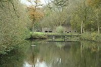 Today many of the forts are still more or less intact. There is renewed interest in the waterline for its natural beauty. Bike tours and hiking paths are organised with the line as theme. Some of the forts are open for bikers/hikers to stay the night. Others have a variety of uses, for example Utrecht University
houses its botanical garden
in Fort Hoofddijk.
Due to the unique nature of the line, the Dutch government is considering whether to nominate the whole defensive line as a UNESCO
world heritage site
, as they did with the ring of fortresses around Amsterdam
.
A twenty-five year plan has been developed by the artist, Agnes Denes
.
In 2010, one of the forts on the Line, Bunker 599, was opened as a publicly-accessible work of art. The bunker was sliced open, with a walkway placed through it forming an installation allowing a view to look into and through the bunker.
Order of forts following the line from north to south.
Forts explicitly build to defend a town are mentioned with the relevant town between brackets
Maurice of Nassau, Prince of Orange
Maurice of Nassau, Prince of Orange was sovereign Prince of Orange from 1618, on the death of his eldest half brother, Philip William, Prince of Orange,...
in the early 17th century, and realised by his half brother Frederick Henry
Frederick Henry, Prince of Orange
Frederick Henry, or Frederik Hendrik in Dutch , was the sovereign Prince of Orange and stadtholder of Holland, Zeeland, Utrecht, Guelders, and Overijssel from 1625 to 1647.-Early life:...
. Combined with natural bodies of water, it could be used to transform the economic heartland of the Dutch Republic
Dutch Republic
The Dutch Republic — officially known as the Republic of the Seven United Netherlands , the Republic of the United Netherlands, or the Republic of the Seven United Provinces — was a republic in Europe existing from 1581 to 1795, preceding the Batavian Republic and ultimately...
almost into an island.
History
Early in the Eighty Years' War of Independence against Spain the Dutch had realized that flooding low lying areas formed an excellent defence against enemy troops, as was demonstrated, for example, during the siege of LeidenSiege of Leiden
The Siege of Leiden occurred during the Eighty Years' War in 1573 and 1574, when the Spanish attempted to capture the rebellious city of Leiden, South Holland, Netherlands, and ultimately failed.-Background:...
, 1574. In the latter half of the war when the economic heartland of the Dutch Republic
Dutch Republic
The Dutch Republic — officially known as the Republic of the Seven United Netherlands , the Republic of the United Netherlands, or the Republic of the Seven United Provinces — was a republic in Europe existing from 1581 to 1795, preceding the Batavian Republic and ultimately...
(i.e. the province of Holland) had been freed of Spanish troops. Maurice of Orange Nassau planned to protect it with a line of flooded land protected by fortresses that ran from the Zuiderzee (present IJsselmeer
IJsselmeer
IJsselmeer is a shallow artificial lake of 1100 km² in the central Netherlands bordering the provinces of Flevoland, North Holland and Friesland, with an average depth of 5 to 6 m. The IJsselmeer is the largest lake in Western Europe....
) down to the river Waal.
Old Dutch Waterline
In 1629 prince Frederick HenryFrederick Henry, Prince of Orange
Frederick Henry, or Frederik Hendrik in Dutch , was the sovereign Prince of Orange and stadtholder of Holland, Zeeland, Utrecht, Guelders, and Overijssel from 1625 to 1647.-Early life:...
started the execution of the plan. Sluices were constructed in dikes and forts and fortified towns were created at strategic points along the line with guns covering especially the dikes that traversed the water line. The water level in the flooded areas was carefully maintained to a level deep enough to make an advance on foot precarious and shallow enough to rule out effective use of boats (other than the flat bottomed gun barges used by the Dutch defenders). Under the water level additional obstacles like ditches, trous de loup
Trou de loup
In medieval fortification, a trou de loup was a type of booby trap or defensive obstacle. Each trou de loup consisted of a conical pit about 2 m deep and 1.2 to 2 m wide at the top...
and later barbed wire
Barbed wire
Barbed wire, also known as barb wire , is a type of fencing wire constructed with sharp edges or points arranged at intervals along the strand. It is used to construct inexpensive fences and is used atop walls surrounding secured property...
and mine
Land mine
A land mine is usually a weight-triggered explosive device which is intended to damage a target—either human or inanimate—by means of a blast and/or fragment impact....
s were hidden. The trees lining the dikes that formed the only roads through the line, could be turned into abatis
Abatis
Abatis, abattis, or abbattis is a term in field fortification for an obstacle formed of the branches of trees laid in a row, with the sharpened tops directed outwards, towards the enemy. The trees are usually interlaced or tied with wire...
in time of war. In wintertime the water level could be manipulated to weaken ice covering, while the ice itself could be used when broken up, to form further obstacles that would expose advancing troops longer to fire from the defenders.
Franco-Dutch War
The Franco-Dutch War, often called simply the Dutch War was a war fought by France, Sweden, the Bishopric of Münster, the Archbishopric of Cologne and England against the United Netherlands, which were later joined by the Austrian Habsburg lands, Brandenburg and Spain to form a quadruple alliance...
(or Third Anglo-Dutch War
Third Anglo-Dutch War
The Third Anglo–Dutch War or Third Dutch War was a military conflict between England and the Dutch Republic lasting from 1672 to 1674. It was part of the larger Franco-Dutch War...
) (1672) when it stopped the armies of Louis XIV
Louis XIV of France
Louis XIV , known as Louis the Great or the Sun King , was a Bourbon monarch who ruled as King of France and Navarre. His reign, from 1643 to his death in 1715, began at the age of four and lasted seventy-two years, three months, and eighteen days...
from conquering the Dutch Republic. And in 1794-1795 the revolutionary French armies only overcame the obstacle posed by the Dutch Water Line due to the heavy frost that had frozen solid the flooded areas.
New Dutch Waterline
United Kingdom of the Netherlands
United Kingdom of the Netherlands is the unofficial name used to refer to Kingdom of the Netherlands during the period after it was first created from part of the First French Empire and before the new kingdom of Belgium split out in 1830...
was formed. Soon after king William I
William I of the Netherlands
William I Frederick, born Willem Frederik Prins van Oranje-Nassau , was a Prince of Orange and the first King of the Netherlands and Grand Duke of Luxembourg....
decided to modernise the waterline. The Water Line was partly shifted east of Utrecht
Utrecht (city)
Utrecht city and municipality is the capital and most populous city of the Dutch province of Utrecht. It is located in the eastern corner of the Randstad conurbation, and is the fourth largest city of the Netherlands with a population of 312,634 on 1 Jan 2011.Utrecht's ancient city centre features...
.
In the next 100 years the main Dutch defence line would be the new water line which was further extended and modernised in the 19th century with forts containing round gun towers reminiscent of Martello tower
Martello tower
Martello towers are small defensive forts built in several countries of the British Empire during the 19th century, from the time of the Napoleonic Wars onwards....
s. The line was mobilised but never attacked during the Franco-Prussian war
Franco-Prussian War
The Franco-Prussian War or Franco-German War, often referred to in France as the 1870 War was a conflict between the Second French Empire and the Kingdom of Prussia. Prussia was aided by the North German Confederation, of which it was a member, and the South German states of Baden, Württemberg and...
in 1870 and World War I
World War I
World War I , which was predominantly called the World War or the Great War from its occurrence until 1939, and the First World War or World War I thereafter, was a major war centred in Europe that began on 28 July 1914 and lasted until 11 November 1918...
.
At the advent of the Second World War most of the earth and brick fortifications in the Water Line were too vulnerable to modern artillery and bombs to withstand a protracted siege. To remedy this a large number of pillboxes were added. However, the Dutch had decided to use a more eastern main defence line, the Grebbe line
Grebbe line
thumb|right|230px|GrebbelinieThe Grebbe Line was a forward defence line of the Dutch Water Line, based on inundation. The Grebbe Line ran from the Grebbeberg in Rhenen northwards until the IJsselmeer....
, and reserved a secondary role for the Water line. When the Grebbe line was broken on May 13, the field army was withdrawn to the Water Line. However, modern warfare could circumvent fixed defense lines (cf. the French Maginot line
Maginot Line
The Maginot Line , named after the French Minister of War André Maginot, was a line of concrete fortifications, tank obstacles, artillery casemates, machine gun posts, and other defences, which France constructed along its borders with Germany and Italy, in light of its experience in World War I,...
). While the Dutch army was fighting a fixed battle at the Grebbe line, German airborne troops had captured the southern approaches into the heart of "Fortress Holland" by surprise — the key points being the bridges at Moerdijk
Moerdijk
Moerdijk is a municipality and a town in the South of the Netherlands, in the province of North Brabant.- History :The municipality of Moerdijk was founded in 1997 following the merger of the municipalities of Fijnaart en Heijningen, Klundert, Standdaarbuiten, Willemstad and Zevenbergen. At that...
, Dordrecht
Dordrecht
Dordrecht , colloquially Dordt, historically in English named Dort, is a city and municipality in the western Netherlands, located in the province of South Holland. It is the fourth largest city of the province, having a population of 118,601 in 2009...
and Rotterdam
Rotterdam
Rotterdam is the second-largest city in the Netherlands and one of the largest ports in the world. Starting as a dam on the Rotte river, Rotterdam has grown into a major international commercial centre...
. When resistance did not cease, the Germans forced the Dutch into surrender by aerial bombing of Rotterdam, and threatening the same for Utrecht and Amsterdam. Therefore, during the Battle of the Netherlands
Battle of the Netherlands
The Battle of the Netherlands was part of Case Yellow , the German invasion of the Low Countries and France during World War II. The battle lasted from 10 May 1940 until 14 May 1940 when the main Dutch forces surrendered...
in May 1940 there was no fighting at the line itself.
After the Second World War, the Dutch government redesigned the idea of a waterline to counter a possible Soviet invasion. This third version of the waterline was erected more to the east, at the IJssel
IJssel
River IJssel , sometimes called Gelderse IJssel to avoid confusion with its Hollandse IJssel namesake in the west of the Netherlands, is a branch of the Rhine in the Dutch provinces of Gelderland and Overijssel...
in Gelderland
Gelderland
Gelderland is the largest province of the Netherlands, located in the central eastern part of the country. The capital city is Arnhem. The two other major cities, Nijmegen and Apeldoorn have more inhabitants. Other major regional centers in Gelderland are Ede, Doetinchem, Zutphen, Tiel, Wijchen,...
. In case of an invasion, the water of the Rhine and the Waal were set to divert into the IJssel, flooding the river and bordering lands. The plan was never tested, and dismantled by the Dutch government in 1963.
Facts
| Length | 85 km |
| Width | 3–5 km |
| Area | 50,000 ha |
| Defensive works | 60 |
| Flood zones | 10 basins |
Today
Utrecht University
Utrecht University is a university in Utrecht, Netherlands. It is one of the oldest universities in the Netherlands and one of the largest in Europe. Established March 26, 1636, it had an enrollment of 29,082 students in 2008, and employed 8,614 faculty and staff, 570 of which are full professors....
houses its botanical garden
Botanical garden
A botanical garden The terms botanic and botanical, and garden or gardens are used more-or-less interchangeably, although the word botanic is generally reserved for the earlier, more traditional gardens. is a well-tended area displaying a wide range of plants labelled with their botanical names...
in Fort Hoofddijk.
Due to the unique nature of the line, the Dutch government is considering whether to nominate the whole defensive line as a UNESCO
UNESCO
The United Nations Educational, Scientific and Cultural Organization is a specialized agency of the United Nations...
world heritage site
World Heritage Site
A UNESCO World Heritage Site is a place that is listed by the UNESCO as of special cultural or physical significance...
, as they did with the ring of fortresses around Amsterdam
Stelling van Amsterdam
The UNESCO World Heritage Site known as the Defence Line of Amsterdam is a 135 km long ring of fortifications around Amsterdam, consisting of 42 forts located between 10 to 15 kilometers the centre, and lowlands that can easily be flooded in time of war...
.
A twenty-five year plan has been developed by the artist, Agnes Denes
Agnes Denes
Agnes Denes is an American Land Art artist. Born in Budapest in 1931, her family moved to Stockholm, then New York City. Denes has been a pioneer of both the environmental art movement and Conceptual art....
.
In 2010, one of the forts on the Line, Bunker 599, was opened as a publicly-accessible work of art. The bunker was sliced open, with a walkway placed through it forming an installation allowing a view to look into and through the bunker.
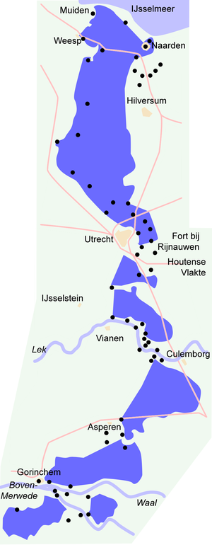
Forts and fortified towns on the New Waterline
To protect weaknesses in the waterline a series of forts and fortified towns have been constructed.Order of forts following the line from north to south.
Forts explicitly build to defend a town are mentioned with the relevant town between brackets
- Permanent batteryArtillery batteryIn military organizations, an artillery battery is a unit of guns, mortars, rockets or missiles so grouped in order to facilitate better battlefield communication and command and control, as well as to provide dispersion for its constituent gunnery crews and their systems...
De Westbatterij (Muiden) - Castle MuiderslotMuiderslotThe Muiderslot is a castle in the Netherlands, located at the mouth of the river Vecht, some 15 kilometers southeast of Amsterdam, in Muiden, where it flows into what used to be the Zuiderzee...
(Muiden) - Fortified town of MuidenMuidenMuiden is a municipality and a town in the Netherlands, in the province of North Holland. It lies at the mouth of the Vecht and is in an area called the Vechtstreek.-Population centres :...
- Fortified town of WeespWeespWeesp is a town and a municipality in the Netherlands, in the province of North Holland. It has a population of 17,533 .Weesp lies next to the rivers de Vecht and Smal Weesp and also next to the Amsterdam-Rhine Canal. It is in an area called the "Vechtstreek"...
- Fort aan de Ossenmarkt (Weesp)
- Fort Uitermeer
- Fort Hinderdam
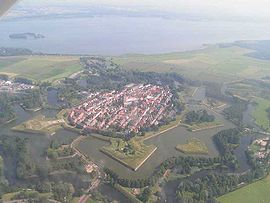
- Fort Ronduit (Naarden)
- Foritified town of Naarden
- Permanent batteries at the Karnemelksloot (Naarden)
- Fort Uitermeer
- Fort Kijkuit
- Fort Spion
- Fort Nieuwersluis
- Fort bij Tienhoven
- Fort aan de Klop (UtrechtUtrecht (city)Utrecht city and municipality is the capital and most populous city of the Dutch province of Utrecht. It is located in the eastern corner of the Randstad conurbation, and is the fourth largest city of the Netherlands with a population of 312,634 on 1 Jan 2011.Utrecht's ancient city centre features...
) - Fort de Gagel (Utrecht)
- Fort op de Ruigenhoeksedijk (Utrecht)
- Fort Blauwkapel (Utrecht)
- Fort op de Voordorpsdijk (Utrecht)
- Fort aan de Biltstraat (Utrecht)
- Minor fort Werk aan de Hoofddijk (Utrecht)
- Fort bij Rhijnauwen (Utrecht)
- Lunetten, a series of small crescent-shaped forts:
- Lunet I (Utrecht)
- Lunet II (Utrecht)
- Lunet III (Utrecht)
- Lunet IV (Utrecht)
- Fort bij Vechten (Utrecht)
- Fort bij 't Hemeltje
- Fort bij JutphaasJutphaasJutphaas is a former village and municipality in the province of Utrecht in the Netherlands. The municipality merged with Vreeswijk in 1971, and is now the northern half of the town of Nieuwegein....
- Minor fort Werk aan de Waalse Wetering
- Minor fort Werk aan de Korte Uitweg
- Lunet aan de Snel
- Fort Honswijk
- Fort PannerdenFort PannerdenFort Pannerden is a disused military fort situated near the village of Pannerden in the southeast of the Netherlands. In November 2006, it became the focus of national news stories because a group of squatters were evicted in a large-scale operation by police, helped by the army...
- Minor fort Werk aan de Groene Weg
- Minor fort Werk aan de Spoel
- Fort Everdingen
- Minor fort Werk op de spoorweg bij de Diefdijk
- Fort bij AsperenAsperenAsperen is a village in the Dutch province of Gelderland. It is a part of the municipality of Lingewaal, and lies about 10 km east of Gorinchem on the river Linge. It received city rights in 1313....
- Fort bij de Nieuwe Steeg
- Fort bij VurenVurenVuren is a village in the Dutch province of Gelderland. It is a part of the municipality of Lingewaal, and is located about 5 km east of Gorinchem....
- Fortified town of GorinchemGorinchemGorinchem , also called Gorkum , is a city and municipality in the western Netherlands, in the province of South Holland. The municipality covers an area of 21.99 km² of which 3.03 km² is water...
- Fortified town of WoudrichemWoudrichemWoudrichem is a municipality and a city in the south of the Netherlands.- Population centres :Almkerk, Andel, Bronkhorst, Duizend Morgen, Eng, Giessen, Oudendijk, Rijswijk, Stenenheul, Uitwijk, Uppel, Waardhuizen, Woudrichem and Zandwijk....
- Castle LoevesteinLoevesteinCastle Loevestein is a medieval castle built by the knight Dirc Loef van Horne between 1357 and 1397....
- Minor fort Werk aan de Bakkerskil
- Fort Steurgat
Dutch waterlines
- Defence Line of AmsterdamStelling van AmsterdamThe UNESCO World Heritage Site known as the Defence Line of Amsterdam is a 135 km long ring of fortifications around Amsterdam, consisting of 42 forts located between 10 to 15 kilometers the centre, and lowlands that can easily be flooded in time of war...
- Frisian Water LineFrisian Water LineThe building of the Friese Waterlinie started around 1580. The traject of the defenceline starts at the Zuidersea, along the river Linde until the De Blessebridge...
- Grebbe lineGrebbe linethumb|right|230px|GrebbelinieThe Grebbe Line was a forward defence line of the Dutch Water Line, based on inundation. The Grebbe Line ran from the Grebbeberg in Rhenen northwards until the IJsselmeer....
- IJssel Line
- Maas Line
- Peel-Raam LinePeel-Raam Linethumb|right|230px|Peel-Raam LineThe Peel-Raam Line was a Dutch defence line built in 1939 and attacked and conquered on 10 May 1940 by the German forces....
Other
- Defence lines of the NetherlandsDefence lines of the Netherlands-Old Defence Lines: Circumvallatielinie van Groenlo *Frisian Water Line Groningse Waterlinie Helperlinie Linie Bergen op Zoom - Steenbergen Linie van Beverwijk Linie van de Eems Linie van de Eendracht Linie van Noord-Holland Oostfrontier...
- Crossing the LinesCrossing the LinesThe Crossing the Lines project brings the communities of Utrecht and Mortsel and the County of Essex together to protect and redevelop flood defencelines in Northwest Europe in an environmentally sustainable manner....
- List of fortifications