
Delaware Canal State Park
Encyclopedia
Delaware Canal State Park is a 830 acres (336 ha) Pennsylvania state park in Bucks
and Northampton
Counties in Pennsylvania
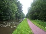
in the United States. The main attraction of the park is the Delaware Canal
, which at 60 miles (96.6 km) is the only canal
that remains fully intact from the towpath
canal-building days of the 19th century. The Delaware Canal runs parallel to the Delaware River
between Easton
and Bristol
.
The Delaware River is the longest free-flowing river east of the Mississippi River
in the United States. It serves as a major migration path for American Shad
and waterfowl
. A visitor's center is located at New Hope
and the park management office is located in Upper Black Eddy
. Within the park are two designated natural areas: Nockamixon Cliffs and River Islands. Recreational opportunities include hiking
, biking and cross-country skiing
along the towpath, fishing
in the canal and river, and canal boat rides.
Delaware Canal State Park was chosen by the Pennsylvania Department of Conservation and Natural Resources
(DCNR) and its Bureau of Parks as one of "Twenty Must-See Pennsylvania State Parks".
Unfortunately, the Delaware Canal State Park has frequently fallen victim to flooding. The path was restored recently, but was washed out again due to flooding in April 2011. Canal paths on the New Jersey side of the Delaware have not suffered the same damage.
 The Delaware Canal runs from the mouth
of the Lehigh River
in Easton
along the Delaware River south to Bristol
. The land along the canal is a mixture of private property and state park lands, with the state park covering some 830 acres (336 ha) along the 60 miles (96.6 km) of the canal.
The course of Delaware Canal State Park is as follows: leaving Easton, the canal enters Williams Township
in Northampton County, and heads south paralleling the Delaware River. The park crosses into Bucks County and passes through the following municipalities: the borough of Riegelsville
, the townships of Durham, Nockamixon, Bridgeton, Tinicum
, Plumstead, and Solebury, the borough of New Hope
, back into Solebury Township, Upper Makefield and Lower Makefield townships, the borough of Yardley
, back into Lower Makefield Township, and the borough of Morrisville
.
The Delaware River has followed a southeast course until now, but after Morrisville in Falls Township
it turns approximately ninety degrees to flow southwest. The canal and park turn southwest earlier and leave the river in Morrisville, cutting off this corner. The park and canal pass through Falls Township to the borough of Tullytown
, where they again follows a course parallel to the river. From Tullytown the canal passes through Bristol Township and ends at the borough of Bristol
.
and other products from the Lehigh Canal
beginning in Mauch Chunk
(today Jim Thorpe) to the industrial centers of the Philadelphia area near Bristol, Pennsylvania. The canal was built in the mid-19th century and ran its last commercial traffic on October 17, 1931. The state bought 40 miles (64.4 km) of the canal in 1931 and bought the remaining 20 miles (32.2 km) in 1940.
The Delaware Division of the Pennsylvania Canal and its towpath became Theodore Roosevelt State Park in the early 1950s, when the berms were restored and the canal was refilled with water. The park was renamed Delaware Canal State Park in 1989. The U.S. Congress designated the Delaware Canal as a Registered National Historic Landmark
and its towpath is a National Recreation Trail
.
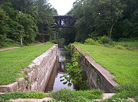
From the 1950s until 2004, visitors to the park were given the chance to explore the canal in mule-drawn canal boats operated from a landing at Lock 11 in New Hope
, and operated north of that point, terminating about 1 miles (1.6 km) north of the Lock 11 landing, near the Rabbit Run and U.S. Route 202
bridges, but was able to navigate all the way to the Virginia Forrest Recreation Area, about 4.5 miles (7.2 km) north of the Lock 11 landing for private parties. Due to lack of maintenance of the canal by DCNR and floods, the barge concession was forced out of business.
, and to protect examples of natural beauty.
s in the Delaware River that are protected from further development. The islands contain archeological clues to the past, provide habitats for migrating waterfowl and songbirds, and offer recreational opportunities in a wild setting for fisherman and canoe
ists.
Some of the islands were originally part of the shoreline of the river and have since been cut off by the effects of erosion, river movement or intervention by man, but other islands have been built up naturally in the river. These river islands grew from silt
deposits that attracted seeds. The seeds grew into plants and trees. The roots of the plants and trees caused the further building of silt and dirt and lead to the formation of the islands. These islands are mostly stable but can be shifted by the erosion effects of the river and flooding.
s along the Delaware River, known as Nockamixon Cliffs, appear to rise from the land, but are in fact formations of very hard stone that have eroded at a much slower pace than the surrounding land. These cliffs are made of weather resistant rock called hornfel, formed at the end of the Triassic Period when magma
rose up from deep within the Earth's crust and flowed into beds of sedimentary rock
. The cliffs "rose" during the Jurassic Period when the surrounding sandstone
and shale
was eroded by wind and water.
The Nockamixon Cliffs are situated along the river in such a way that the north facing cliffs in Pennsylvania receive little to no direct sunlight, causing their temperatures to be cooler than normal. The cool habitat supports an alpine-Arctic plant community that is very unusual for the latitude
of Delaware Canal State Park. The south facing cliffs in New Jersey
at Delaware and Raritan Canal State Park
have a nearly opposite habitat. They receive a high amount of sunshine, which makes the area near the cliffs warmer and drier than usual, creating a habitat for plants that normally thrive in much more arid areas.
run. The fish are the largest members of the herring
family. They are an anadromous species, which means they are born and spawn in fresh water
but spend the majority of their lives in salt water (of the Atlantic Ocean
). After spending three to six years at sea, the shad return to the waters of their birth to spawn. Unlike salmon
, not all shad die after spawning; some survive and return to the ocean.
The American Shad have long been a vital food resource for the people living along the Delaware River. The Lenape
(or Delaware) tribe depended on the migration of the shad as a staple of their diet. They harvested the fish and prepared them in several ways. Some fish were grilled quickly on wooden racks and others were preserved for later use by smoking them or air drying. The Moravians and other early European settlers in the Delaware River Valley also depended on shad for their diets.
The booming population along the Delaware River, especially in Philadelphia
, Easton
, Camden
and Trenton
, led to increased levels of pollution in the Delaware River. Sewage and industrial pollution combined with extensive overfishing nearly led to a total collapse of the shad population. The pollution was so bad that in the years following World War II
nearly 20 miles (32.2 km) of the river was a dead zone, free of dissolved oxygen
. This dead zone prevented the migration of shad. Dam
s built during the canal era to provide water for the canals also limited the migration patterns of the shad. The combination of dams and pollution nearly caused the shad to abandon the Delaware River and its tributaries altogether.
Beginning in the 1960s, an effort began to re-establish the population of American Shad in the Delaware River basin. Pollution levels dropped tremendously, and fish ladder
s were built to allow the shad to bypass the dams that blocked their way and to migrate further up the river. These efforts have led to the restoration of the American Shad in the Delaware River.
 The Delaware Canal towpath runs along the canal for 60 miles (96.6 km) from Easton to Bristol and was once used by teams of mule
s as they towed the barges up and down the canal. Today it is a National Recreational Trail open to walkers, joggers
, cyclists
, bird watchers
and cross-country skiers
. Five bridges over the Delaware River connect the paths in Delaware Canal State Park with paths in New Jersey at the Delaware and Raritan Canal State Park
.
The Delaware River and the Delaware Canal are warm water fisheries. Common game fish include the American shad, striped bass
, walleye
and smallmouth bass
. The river is also popular with people who wish to explore it in canoe
s and other small non-powered watercraft. All boats must have a launch permit for Pennsylvania or New Jersey or a current registration from any state.
Bucks County, Pennsylvania
- Industry and commerce :The boroughs of Bristol and Morrisville were prominent industrial centers along the Northeast Corridor during World War II. Suburban development accelerated in Lower Bucks in the 1950s with the opening of Levittown, Pennsylvania, the second such "Levittown" designed by...
and Northampton
Northampton County, Pennsylvania
As of the 2010 census, the county was 86.3% White, 5.0% Black or African American, 0.2% Native American or Alaskan Native, 2.4% Asian, 0.0% Native Hawaiian, 2.2% were two or more races, and 3.8% were some other race. 10.5% of the population were of Hispanic or Latino ancestry.As of the census of...
Counties in Pennsylvania
Pennsylvania
The Commonwealth of Pennsylvania is a U.S. state that is located in the Northeastern and Mid-Atlantic regions of the United States. The state borders Delaware and Maryland to the south, West Virginia to the southwest, Ohio to the west, New York and Ontario, Canada, to the north, and New Jersey to...
in the United States. The main attraction of the park is the Delaware Canal
Pennsylvania Canal (Delaware Division)
The Delaware Division of the Pennsylvania Canal, more commonly called the Delaware Canal, runs from the Lehigh River at Easton south to Bristol...
, which at 60 miles (96.6 km) is the only canal
Canal
Canals are man-made channels for water. There are two types of canal:#Waterways: navigable transportation canals used for carrying ships and boats shipping goods and conveying people, further subdivided into two kinds:...
that remains fully intact from the towpath
Towpath
A towpath is a road or trail on the bank of a river, canal, or other inland waterway. The purpose of a towpath is to allow a land vehicle, beasts of burden, or a team of human pullers to tow a boat, often a barge...
canal-building days of the 19th century. The Delaware Canal runs parallel to the Delaware River
Delaware River
The Delaware River is a major river on the Atlantic coast of the United States.A Dutch expedition led by Henry Hudson in 1609 first mapped the river. The river was christened the South River in the New Netherland colony that followed, in contrast to the North River, as the Hudson River was then...
between Easton
Easton, Pennsylvania
Easton is a city in Northampton County, Pennsylvania, United States. The population was 26,800 as of the 2010 census. It is the county seat of Northampton County....
and Bristol
Bristol, Pennsylvania
Bristol is a borough in Bucks County, Pennsylvania, northeast of Philadelphia opposite Burlington, N.J. on the Delaware River. Bristol was first incorporated in 1720. Although its charter was revised in 1905, the original charter remains in effect, making Bristol one of the older boroughs in...
.
The Delaware River is the longest free-flowing river east of the Mississippi River
Mississippi River
The Mississippi River is the largest river system in North America. Flowing entirely in the United States, this river rises in western Minnesota and meanders slowly southwards for to the Mississippi River Delta at the Gulf of Mexico. With its many tributaries, the Mississippi's watershed drains...
in the United States. It serves as a major migration path for American Shad
American shad
-Introduction:The American shad or Atlantic shad, Alosa sapidissima, is a species of anadromous fish in family Clupeidae of order Clupeiformes. It is not closely related to the other North American shads...
and waterfowl
Waterfowl
Waterfowl are certain wildfowl of the order Anseriformes, especially members of the family Anatidae, which includes ducks, geese, and swans....
. A visitor's center is located at New Hope
New Hope, Pennsylvania
New Hope, formerly known as Coryell's Ferry, is a borough in Bucks County, Pennsylvania, USA. The population was 2,528 at the 2010 census. The borough lies on the west bank of the Delaware River at its confluence with Aquetong Creek. A two-lane bridge carries automobile and foot traffic across the...
and the park management office is located in Upper Black Eddy
Upper Black Eddy, Pennsylvania
The village of Upper Black Eddy aka "UBE" is located in northern Bucks County, Pennsylvania who have second homes here due to the early american 18th and 19th century charm, rural character of the area and short distance from the "City" located only 58 miles to the east.Upper Black Eddy...
. Within the park are two designated natural areas: Nockamixon Cliffs and River Islands. Recreational opportunities include hiking
Hiking
Hiking is an outdoor activity which consists of walking in natural environments, often in mountainous or other scenic terrain. People often hike on hiking trails. It is such a popular activity that there are numerous hiking organizations worldwide. The health benefits of different types of hiking...
, biking and cross-country skiing
Cross-country skiing
Cross-country skiing is a winter sport in which participants propel themselves across snow-covered terrain using skis and poles...
along the towpath, fishing
Fishing
Fishing is the activity of trying to catch wild fish. Fish are normally caught in the wild. Techniques for catching fish include hand gathering, spearing, netting, angling and trapping....
in the canal and river, and canal boat rides.
Delaware Canal State Park was chosen by the Pennsylvania Department of Conservation and Natural Resources
Pennsylvania Department of Conservation and Natural Resources
The Pennsylvania Department of Conservation and Natural Resources , established on July 1, 1995, is the agency in the U.S. State of Pennsylvania responsible for maintaining and preserving the state's 117 state parks and 20 state forests; providing information on the state's natural resources; and...
(DCNR) and its Bureau of Parks as one of "Twenty Must-See Pennsylvania State Parks".
Unfortunately, the Delaware Canal State Park has frequently fallen victim to flooding. The path was restored recently, but was washed out again due to flooding in April 2011. Canal paths on the New Jersey side of the Delaware have not suffered the same damage.
Course
Confluence (geography)
In geography, a confluence is the meeting of two or more bodies of water. It usually refers to the point where two streams flow together, merging into a single stream...
of the Lehigh River
Lehigh River
The Lehigh River, a tributary of the Delaware River, is a river located in eastern Pennsylvania, in the United States. Part of the Lehigh, along with a number of its tributaries, is designated a Pennsylvania Scenic River by the state's Department of Conservation and Natural Resources...
in Easton
Easton, Pennsylvania
Easton is a city in Northampton County, Pennsylvania, United States. The population was 26,800 as of the 2010 census. It is the county seat of Northampton County....
along the Delaware River south to Bristol
Bristol, Pennsylvania
Bristol is a borough in Bucks County, Pennsylvania, northeast of Philadelphia opposite Burlington, N.J. on the Delaware River. Bristol was first incorporated in 1720. Although its charter was revised in 1905, the original charter remains in effect, making Bristol one of the older boroughs in...
. The land along the canal is a mixture of private property and state park lands, with the state park covering some 830 acres (336 ha) along the 60 miles (96.6 km) of the canal.
The course of Delaware Canal State Park is as follows: leaving Easton, the canal enters Williams Township
Williams Township, Northampton County, Pennsylvania
Williams Township is a township in Northampton County, Pennsylvania, United States. Williams Township is located in the Lehigh Valley region of the state.The population of Williams Township was 4,470 at the 2000 census.-History:...
in Northampton County, and heads south paralleling the Delaware River. The park crosses into Bucks County and passes through the following municipalities: the borough of Riegelsville
Riegelsville, Pennsylvania
Riegelsville is a borough in Bucks County, Pennsylvania, United States. The population was 868 at the 2010 census.-History:Benjamin Riegel founded Riegelsville. The original, and now historic, that he built in 1838 still stands. This historic stone inn has offered food and lodging to Bucks County...
, the townships of Durham, Nockamixon, Bridgeton, Tinicum
Tinicum Township, Bucks County, Pennsylvania
Tinicum Township is a township in Bucks County, Pennsylvania, United States. The population was 3,995 at the 2010 census.The Uhlerstown-Frenchtown Bridge, a free Delaware River Joint Toll Bridge Commission bridge over the Delaware River, connects Uhlerstown to Frenchtown in Hunterdon County, New...
, Plumstead, and Solebury, the borough of New Hope
New Hope, Pennsylvania
New Hope, formerly known as Coryell's Ferry, is a borough in Bucks County, Pennsylvania, USA. The population was 2,528 at the 2010 census. The borough lies on the west bank of the Delaware River at its confluence with Aquetong Creek. A two-lane bridge carries automobile and foot traffic across the...
, back into Solebury Township, Upper Makefield and Lower Makefield townships, the borough of Yardley
Yardley, Pennsylvania
Yardley is a borough in Bucks County, Pennsylvania, United States. The small community of Yardley is bordered by the Delaware River and Ewing, New Jersey on the east, and by Lower Makefield Township on the north, west, and south...
, back into Lower Makefield Township, and the borough of Morrisville
Morrisville, Bucks County, Pennsylvania
Morrisville is a borough in Bucks County, Pennsylvania, United States. The population was 8,728 at the 2010 census.-Geography:Morrisville is located at . It is situated on the Delaware River directly across from Trenton, New Jersey...
.
The Delaware River has followed a southeast course until now, but after Morrisville in Falls Township
Falls Township, Bucks County, Pennsylvania
Falls Township is a township in Bucks County, Pennsylvania, United States. The population was 34,300 at the 2010 census. Portions of Fairless Hills and Levittown, Pennsylvania, are located in the township...
it turns approximately ninety degrees to flow southwest. The canal and park turn southwest earlier and leave the river in Morrisville, cutting off this corner. The park and canal pass through Falls Township to the borough of Tullytown
Tullytown, Pennsylvania
Tullytown is a borough in Bucks County, Pennsylvania, United States. The population was 1,872 at the 2010 census. Part of Levittown is located in Tullytown.-Geography:Tullytown is located at ....
, where they again follows a course parallel to the river. From Tullytown the canal passes through Bristol Township and ends at the borough of Bristol
Bristol, Pennsylvania
Bristol is a borough in Bucks County, Pennsylvania, northeast of Philadelphia opposite Burlington, N.J. on the Delaware River. Bristol was first incorporated in 1720. Although its charter was revised in 1905, the original charter remains in effect, making Bristol one of the older boroughs in...
.
History
The Delaware Canal stretches from Bristol to Easton along the Delaware River. It was used to haul coalAnthracite coal
Anthracite is a hard, compact variety of mineral coal that has a high luster...
and other products from the Lehigh Canal
Lehigh Canal
The Lehigh Canal was constructed by the Lehigh Coal & Navigation Company to carry anthracite from the upper Lehigh Valley to the urban markets of the northeast, especially Philadelphia...
beginning in Mauch Chunk
Jim Thorpe, Pennsylvania
Jim Thorpe is a borough in Carbon County, Pennsylvania, USA. The population was 4,804 at the 2000 census. It is the county seat of Carbon County. The town has been called the "Switzerland of America" due to the picturesque scenery, mountainous location, and architecture; as well as the "Gateway to...
(today Jim Thorpe) to the industrial centers of the Philadelphia area near Bristol, Pennsylvania. The canal was built in the mid-19th century and ran its last commercial traffic on October 17, 1931. The state bought 40 miles (64.4 km) of the canal in 1931 and bought the remaining 20 miles (32.2 km) in 1940.
The Delaware Division of the Pennsylvania Canal and its towpath became Theodore Roosevelt State Park in the early 1950s, when the berms were restored and the canal was refilled with water. The park was renamed Delaware Canal State Park in 1989. The U.S. Congress designated the Delaware Canal as a Registered National Historic Landmark
National Historic Landmark
A National Historic Landmark is a building, site, structure, object, or district, that is officially recognized by the United States government for its historical significance...
and its towpath is a National Recreation Trail
National Recreation Trail
National Recreation Trail is a designation given to existing trails that contribute to health, conservation, and recreation goals in the United States. Over 1,000 trails in all 50 U.S. states, available for public use and ranging from less than a mile to in length, have been designated as NRTs...
.
From the 1950s until 2004, visitors to the park were given the chance to explore the canal in mule-drawn canal boats operated from a landing at Lock 11 in New Hope
New Hope, Pennsylvania
New Hope, formerly known as Coryell's Ferry, is a borough in Bucks County, Pennsylvania, USA. The population was 2,528 at the 2010 census. The borough lies on the west bank of the Delaware River at its confluence with Aquetong Creek. A two-lane bridge carries automobile and foot traffic across the...
, and operated north of that point, terminating about 1 miles (1.6 km) north of the Lock 11 landing, near the Rabbit Run and U.S. Route 202
U.S. Route 202
U.S. Route 202 is a highway stretching from Delaware to Maine, also passing through the states of Pennsylvania, New Jersey, New York, Connecticut, Massachusetts, and New Hampshire....
bridges, but was able to navigate all the way to the Virginia Forrest Recreation Area, about 4.5 miles (7.2 km) north of the Lock 11 landing for private parties. Due to lack of maintenance of the canal by DCNR and floods, the barge concession was forced out of business.
Natural areas
Pennsylvania state park natural areas are special areas that are set aside within the state parks to allow the natural condition of biological and physical processes to operate, usually without human intervention. There are two such areas at the Delaware Canal State Park: River Islands and Nockamixon Cliffs. These natural areas are set aside to provide scientists with the chance to observe the natural ecosystems at work and to protect examples of unique and typical plant life, animal habitatsHabitat (ecology)
A habitat is an ecological or environmental area that is inhabited by a particular species of animal, plant or other type of organism...
, and to protect examples of natural beauty.
River islands
There are eleven islandIsland
An island or isle is any piece of sub-continental land that is surrounded by water. Very small islands such as emergent land features on atolls can be called islets, cays or keys. An island in a river or lake may be called an eyot , or holm...
s in the Delaware River that are protected from further development. The islands contain archeological clues to the past, provide habitats for migrating waterfowl and songbirds, and offer recreational opportunities in a wild setting for fisherman and canoe
Canoe
A canoe or Canadian canoe is a small narrow boat, typically human-powered, though it may also be powered by sails or small electric or gas motors. Canoes are usually pointed at both bow and stern and are normally open on top, but can be decked over A canoe (North American English) or Canadian...
ists.
Some of the islands were originally part of the shoreline of the river and have since been cut off by the effects of erosion, river movement or intervention by man, but other islands have been built up naturally in the river. These river islands grew from silt
Silt
Silt is granular material of a size somewhere between sand and clay whose mineral origin is quartz and feldspar. Silt may occur as a soil or as suspended sediment in a surface water body...
deposits that attracted seeds. The seeds grew into plants and trees. The roots of the plants and trees caused the further building of silt and dirt and lead to the formation of the islands. These islands are mostly stable but can be shifted by the erosion effects of the river and flooding.
Nockamixon Cliffs
The cliffCliff
In geography and geology, a cliff is a significant vertical, or near vertical, rock exposure. Cliffs are formed as erosion landforms due to the processes of erosion and weathering that produce them. Cliffs are common on coasts, in mountainous areas, escarpments and along rivers. Cliffs are usually...
s along the Delaware River, known as Nockamixon Cliffs, appear to rise from the land, but are in fact formations of very hard stone that have eroded at a much slower pace than the surrounding land. These cliffs are made of weather resistant rock called hornfel, formed at the end of the Triassic Period when magma
Magma
Magma is a mixture of molten rock, volatiles and solids that is found beneath the surface of the Earth, and is expected to exist on other terrestrial planets. Besides molten rock, magma may also contain suspended crystals and dissolved gas and sometimes also gas bubbles. Magma often collects in...
rose up from deep within the Earth's crust and flowed into beds of sedimentary rock
Sedimentary rock
Sedimentary rock are types of rock that are formed by the deposition of material at the Earth's surface and within bodies of water. Sedimentation is the collective name for processes that cause mineral and/or organic particles to settle and accumulate or minerals to precipitate from a solution....
. The cliffs "rose" during the Jurassic Period when the surrounding sandstone
Sandstone
Sandstone is a sedimentary rock composed mainly of sand-sized minerals or rock grains.Most sandstone is composed of quartz and/or feldspar because these are the most common minerals in the Earth's crust. Like sand, sandstone may be any colour, but the most common colours are tan, brown, yellow,...
and shale
Shale
Shale is a fine-grained, clastic sedimentary rock composed of mud that is a mix of flakes of clay minerals and tiny fragments of other minerals, especially quartz and calcite. The ratio of clay to other minerals is variable. Shale is characterized by breaks along thin laminae or parallel layering...
was eroded by wind and water.
The Nockamixon Cliffs are situated along the river in such a way that the north facing cliffs in Pennsylvania receive little to no direct sunlight, causing their temperatures to be cooler than normal. The cool habitat supports an alpine-Arctic plant community that is very unusual for the latitude
Latitude
In geography, the latitude of a location on the Earth is the angular distance of that location south or north of the Equator. The latitude is an angle, and is usually measured in degrees . The equator has a latitude of 0°, the North pole has a latitude of 90° north , and the South pole has a...
of Delaware Canal State Park. The south facing cliffs in New Jersey
New Jersey
New Jersey is a state in the Northeastern and Middle Atlantic regions of the United States. , its population was 8,791,894. It is bordered on the north and east by the state of New York, on the southeast and south by the Atlantic Ocean, on the west by Pennsylvania and on the southwest by Delaware...
at Delaware and Raritan Canal State Park
Delaware and Raritan Canal State Park
Delaware and Raritan Canal State Park is a New Jersey state park along the Delaware and Raritan Canal.In 1974, most of the canal system was declared a New Jersey state park. It remains one today, and is used for canoeing, kayaking, and fishing...
have a nearly opposite habitat. They receive a high amount of sunshine, which makes the area near the cliffs warmer and drier than usual, creating a habitat for plants that normally thrive in much more arid areas.
American shad
The Delaware River is used by American shad during their spawningSpawn (biology)
Spawn refers to the eggs and sperm released or deposited, usually into water, by aquatic animals. As a verb, spawn refers to the process of releasing the eggs and sperm, also called spawning...
run. The fish are the largest members of the herring
Herring
Herring is an oily fish of the genus Clupea, found in the shallow, temperate waters of the North Pacific and the North Atlantic oceans, including the Baltic Sea. Three species of Clupea are recognized. The main taxa, the Atlantic herring and the Pacific herring may each be divided into subspecies...
family. They are an anadromous species, which means they are born and spawn in fresh water
Fresh Water
Fresh Water is the debut album by Australian rock and blues singer Alison McCallum, released in 1972. Rare for an Australian artist at the time, it came in a gatefold sleeve...
but spend the majority of their lives in salt water (of the Atlantic Ocean
Atlantic Ocean
The Atlantic Ocean is the second-largest of the world's oceanic divisions. With a total area of about , it covers approximately 20% of the Earth's surface and about 26% of its water surface area...
). After spending three to six years at sea, the shad return to the waters of their birth to spawn. Unlike salmon
Salmon
Salmon is the common name for several species of fish in the family Salmonidae. Several other fish in the same family are called trout; the difference is often said to be that salmon migrate and trout are resident, but this distinction does not strictly hold true...
, not all shad die after spawning; some survive and return to the ocean.
The American Shad have long been a vital food resource for the people living along the Delaware River. The Lenape
Lenape
The Lenape are an Algonquian group of Native Americans of the Northeastern Woodlands. They are also called Delaware Indians. As a result of the American Revolutionary War and later Indian removals from the eastern United States, today the main groups live in Canada, where they are enrolled in the...
(or Delaware) tribe depended on the migration of the shad as a staple of their diet. They harvested the fish and prepared them in several ways. Some fish were grilled quickly on wooden racks and others were preserved for later use by smoking them or air drying. The Moravians and other early European settlers in the Delaware River Valley also depended on shad for their diets.
The booming population along the Delaware River, especially in Philadelphia
Philadelphia, Pennsylvania
Philadelphia is the largest city in the Commonwealth of Pennsylvania and the county seat of Philadelphia County, with which it is coterminous. The city is located in the Northeastern United States along the Delaware and Schuylkill rivers. It is the fifth-most-populous city in the United States,...
, Easton
Easton, Pennsylvania
Easton is a city in Northampton County, Pennsylvania, United States. The population was 26,800 as of the 2010 census. It is the county seat of Northampton County....
, Camden
Camden, New Jersey
The city of Camden is the county seat of Camden County, New Jersey. It is located across the Delaware River from Philadelphia, Pennsylvania. As of the 2010 United States Census, the city had a total population of 77,344...
and Trenton
Trenton, New Jersey
Trenton is the capital of the U.S. state of New Jersey and the county seat of Mercer County. As of the 2010 United States Census, Trenton had a population of 84,913...
, led to increased levels of pollution in the Delaware River. Sewage and industrial pollution combined with extensive overfishing nearly led to a total collapse of the shad population. The pollution was so bad that in the years following World War II
World War II
World War II, or the Second World War , was a global conflict lasting from 1939 to 1945, involving most of the world's nations—including all of the great powers—eventually forming two opposing military alliances: the Allies and the Axis...
nearly 20 miles (32.2 km) of the river was a dead zone, free of dissolved oxygen
Oxygen
Oxygen is the element with atomic number 8 and represented by the symbol O. Its name derives from the Greek roots ὀξύς and -γενής , because at the time of naming, it was mistakenly thought that all acids required oxygen in their composition...
. This dead zone prevented the migration of shad. Dam
Dam
A dam is a barrier that impounds water or underground streams. Dams generally serve the primary purpose of retaining water, while other structures such as floodgates or levees are used to manage or prevent water flow into specific land regions. Hydropower and pumped-storage hydroelectricity are...
s built during the canal era to provide water for the canals also limited the migration patterns of the shad. The combination of dams and pollution nearly caused the shad to abandon the Delaware River and its tributaries altogether.
Beginning in the 1960s, an effort began to re-establish the population of American Shad in the Delaware River basin. Pollution levels dropped tremendously, and fish ladder
Fish ladder
A fish ladder, also known as a fishway, fish pass or fish steps, is a structure on or around artificial barriers to facilitate diadromous fishes' natural migration. Most fishways enable fish to pass around the barriers by swimming and leaping up a series of relatively low steps into the waters on...
s were built to allow the shad to bypass the dams that blocked their way and to migrate further up the river. These efforts have led to the restoration of the American Shad in the Delaware River.
Recreation
Mule
A mule is the offspring of a male donkey and a female horse. Horses and donkeys are different species, with different numbers of chromosomes. Of the two F1 hybrids between these two species, a mule is easier to obtain than a hinny...
s as they towed the barges up and down the canal. Today it is a National Recreational Trail open to walkers, joggers
Jogging
Jogging is a form of trotting or running at a slow or leisurely pace. The main intention is to increase fitness with less stress on the body than from faster running.-Definition:...
, cyclists
Cycling
Cycling, also called bicycling or biking, is the use of bicycles for transport, recreation, or for sport. Persons engaged in cycling are cyclists or bicyclists...
, bird watchers
Birdwatching
Birdwatching or birding is the observation of birds as a recreational activity. It can be done with the naked eye, through a visual enhancement device like binoculars and telescopes, or by listening for bird sounds. Birding often involves a significant auditory component, as many bird species are...
and cross-country skiers
Cross-country skiing
Cross-country skiing is a winter sport in which participants propel themselves across snow-covered terrain using skis and poles...
. Five bridges over the Delaware River connect the paths in Delaware Canal State Park with paths in New Jersey at the Delaware and Raritan Canal State Park
Delaware and Raritan Canal State Park
Delaware and Raritan Canal State Park is a New Jersey state park along the Delaware and Raritan Canal.In 1974, most of the canal system was declared a New Jersey state park. It remains one today, and is used for canoeing, kayaking, and fishing...
.
The Delaware River and the Delaware Canal are warm water fisheries. Common game fish include the American shad, striped bass
Striped bass
The striped bass is the state fish of Maryland, Rhode Island, South Carolina, and the state saltwater fish of New York, Virginia, and New Hampshire...
, walleye
Walleye
Walleye is a freshwater perciform fish native to most of Canada and to the northern United States. It is a North American close relative of the European pikeperch...
and smallmouth bass
Smallmouth bass
The smallmouth bass is a species of freshwater fish in the sunfish family of the order Perciformes. It is the type species of its genus...
. The river is also popular with people who wish to explore it in canoe
Canoe
A canoe or Canadian canoe is a small narrow boat, typically human-powered, though it may also be powered by sails or small electric or gas motors. Canoes are usually pointed at both bow and stern and are normally open on top, but can be decked over A canoe (North American English) or Canadian...
s and other small non-powered watercraft. All boats must have a launch permit for Pennsylvania or New Jersey or a current registration from any state.
Nearby state parks
The following state parks are within 30 miles (48.3 km) of Delaware Canal State Park:- Beltzville State ParkBeltzville State ParkBeltzville State Park is a Pennsylvania state park in Franklin and Towamensing townships, Carbon County, Pennsylvania in the United States. The park was developed around the U.S. Army Corps of Engineers flood control project, Beltzville Dam on Pohopoco Creek. Beltzville Lake is a with of...
(Carbon CountyCarbon County, PennsylvaniaAs of the census of 2000, there were 58,802 people, 23,701 households, and 16,424 families residing in the county. The population density was 154 people per square mile . There were 30,492 housing units at an average density of 80 per square mile...
) - Benjamin Rush State ParkBenjamin Rush State ParkBenjamin Rush State Park is a Pennsylvania state park in Philadelphia, Philadelphia County, Pennsylvania, in the United States. The park is undeveloped and is the site of community gardens, believed to be one of the largest in the world. The park is home to the Northeast Radio Controlled Airplane...
(Philadelphia CountyPhiladelphia County, Pennsylvania-History:Tribes of Lenape were the first known occupants in the area which became Philadelphia County. The first European settlers were Swedes and Finns who arrived in 1638. The Netherlands seized the area in 1655, but permanently lost control to England in 1674...
) - Big Pocono State ParkBig Pocono State ParkBig Pocono State Park is a Pennsylvania state park in Jackson and Pocono townships in Monroe County, Pennsylvania in northeastern Pennsylvania in the United States...
(Monroe CountyMonroe County, Pennsylvania-National protected areas:* Delaware Water Gap National Recreation Area * Middle Delaware National Scenic River -Demographics:As of the census of 2010, there are 176,567 people, 49,454 households, and 36,447 families residing in the county. The population density was 228 people per square mile...
) - Bull's Island State Park (New JerseyNew JerseyNew Jersey is a state in the Northeastern and Middle Atlantic regions of the United States. , its population was 8,791,894. It is bordered on the north and east by the state of New York, on the southeast and south by the Atlantic Ocean, on the west by Pennsylvania and on the southwest by Delaware...
) - Delaware and Raritan Canal State ParkDelaware and Raritan Canal State ParkDelaware and Raritan Canal State Park is a New Jersey state park along the Delaware and Raritan Canal.In 1974, most of the canal system was declared a New Jersey state park. It remains one today, and is used for canoeing, kayaking, and fishing...
(New Jersey) - Evansburg State ParkEvansburg State ParkEvansburg State Park is a Pennsylvania state park in Lower Providence, Lower Salford, Skippack, Towamencin, and Worcester Townships in Montgomery County, Pennsylvania in the United States. The park has a variety of habitats including forests, meadows, old fields, and farmland...
(Montgomery CountyMontgomery County, PennsylvaniaMontgomery County is a county located in the U.S. state of Pennsylvania, in the United States. As of 2010, the population was 799,874, making it the third most populous county in Pennsylvania . The county seat is Norristown.The county was created on September 10, 1784, out of land originally part...
) - Fort Washington State ParkFort Washington State ParkFort Washington State Park is a Pennsylvania state park in Springfield and Whitemarsh Townships, Montgomery County, Pennsylvania in the United States. The park is noted for the springtime flowering of dogwood trees, and is popular with families for picnics and hiking...
(Montgomery County) - Hacklebarney State ParkHacklebarney State Park300px|right|thumb| One of the waterfalls at Hacklebarney State Park, New JerseyHacklebarney State Park is state park of the U.S. state of New Jersey, located between Long Valley and Chester in Morris County. The park contains of land in a glacial valley carved by the Black River and its...
(New Jersey) - Jacobsburg Environmental Education CenterJacobsburg Environmental Education CenterJacobsburg Environmental Education Center is a Pennsylvania state park near Wind Gap, in Bushkill Township, Northampton County in Pennsylvania, in the United States. The Jacobsburg National Historic District is almost entirely surrounded by the park...
(Northampton County) - Neshaminy State ParkNeshaminy State ParkNeshaminy State Park is a Pennsylvania state park in Bensalem Township, Bucks County, Pennsylvania in the United States. Visitors to the park can catch a glimpse of the Philadelphia skyline from a hiking trail on Logan Point. The park is located at the confluence of Neshaminy Creek and the...
(Bucks County) - Nockamixon State Park (Bucks County)
- Norristown Farm ParkNorristown Farm ParkNorristown Farm Park is a Pennsylvania state park in East Norriton and West Norriton Townships and the Borough of Norristown, Montgomery County, Pennsylvania, in the United States. It is operated in partnership with the Montgomery County Department of Parks. The park is a working farm on the site...
(Montgomery County) - Ralph Stover State ParkRalph Stover State ParkRalph Stover State Park is a Pennsylvania state park on in Plumstead and Tinicum Townships, Bucks County, Pennsylvania in the United States. It is a very popular destination for whitewater kayaking on Tohickon Creek and rock climbing on High Rocks...
(Bucks County) - Rancocas State Park (New Jersey)
- Ridley Creek State ParkRidley Creek State ParkRidley Creek State Park is a Pennsylvania state park in Edgmont, Middletown and Upper Providence Townships, Delaware County, Pennsylvania in the United States. The park, about north of the county seat of Media, offers many recreational activities, such as hiking, biking, fishing, and picnicking....
(Delaware CountyDelaware County, PennsylvaniaDelaware County is a county located in the U.S. state of Pennsylvania. As of 2010, the population was 558,979, making it Pennsylvania's fifth most populous county, behind Philadelphia, Allegheny, Montgomery, and Bucks counties....
) - Round Valley State Park (New Jersey)
- Tyler State Park (Bucks County)
- Voorhees State ParkVoorhees State ParkVoorhees State Park is a state park in the U.S. state of New Jersey. It is 1400 acres in area and is located in Glen Gardner Borough. The park is operated and maintained by the New Jersey Division of Parks and Forestry....
(New Jersey) - Washington Crossing State ParkWashington Crossing State ParkWashington Crossing State Park is a state park in the U.S. state of New Jersey that is part of Washington's Crossing, a U.S. National Historic Landmark area. It is located in the Titusville section of Hopewell Township in Mercer County, north of Trenton along the Delaware River...
(New Jersey) - Washington Rock State ParkWashington Rock State ParkWashington Rock State Park is a scenic state park on top the first Watchung Mountain in Green Brook Township, New Jersey. The park is operated and maintained by the New Jersey Division of Parks and Forestry....
(New Jersey)