
American shad
Encyclopedia
Introduction
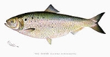
The American shad or Atlantic shad, Alosa sapidissima, is a speciesSpecies
In biology, a species is one of the basic units of biological classification and a taxonomic rank. A species is often defined as a group of organisms capable of interbreeding and producing fertile offspring. While in many cases this definition is adequate, more precise or differing measures are...
of anadromous fish
Fish
Fish are a paraphyletic group of organisms that consist of all gill-bearing aquatic vertebrate animals that lack limbs with digits. Included in this definition are the living hagfish, lampreys, and cartilaginous and bony fish, as well as various extinct related groups...
in family
Family (biology)
In biological classification, family is* a taxonomic rank. Other well-known ranks are life, domain, kingdom, phylum, class, order, genus, and species, with family fitting between order and genus. As for the other well-known ranks, there is the option of an immediately lower rank, indicated by the...
Clupeidae
Clupeidae
Clupeidae is the family of the herrings, shads, sardines, hilsa and menhadens. It includes many of the most important food fishes in the world.-Description and biology:...
of order
Order (biology)
In scientific classification used in biology, the order is# a taxonomic rank used in the classification of organisms. Other well-known ranks are life, domain, kingdom, phylum, class, family, genus, and species, with order fitting in between class and family...
Clupeiformes
Clupeiformes
Clupeiformes is the order of ray-finned fish that includes the herring family, Clupeidae, and the anchovy family, Engraulidae. The group includes many of the most important food fish....
. It is not closely related to the other North American shads. Rather, it seems to form a lineage that diverged from a common ancestor of the European taxa before these diversified (Faria et al. 2006).
It weighs between three and eight pounds
Pound (mass)
The pound or pound-mass is a unit of mass used in the Imperial, United States customary and other systems of measurement...
and has a delicate flavour when cooked. It is considered flavourful enough to not require sauces, herbs or spices. It can be boiled, fillet
Fillet (cut)
A fillet is a cut or slice of boneless meat or fish.- Meat :In the case of beef, in the USA, the term most often refers to beef tenderloin, especially filet mignon.- Chicken :...
ed and fried in butter, or baked. Traditionally, a little vinegar
Vinegar
Vinegar is a liquid substance consisting mainly of acetic acid and water, the acetic acid being produced through the fermentation of ethanol by acetic acid bacteria. Commercial vinegar is produced either by fast or slow fermentation processes. Slow methods generally are used with traditional...
is sprinkled over it on the plate. In the eastern United States, roe
Roe
Roe or hard roe is the fully ripe internal egg masses in the ovaries, or the released external egg masses of fish and certain marine animals, such as shrimp, scallop and sea urchins...
shad (females) are prized because the eggs are considered a delicacy.
Habits
The shad spends most of its life at sea, but swims up fresh rivers to spawn. The fish survive breeding and can return to the sea; they do not inhabit fresh water except to spawn. At sea, shad are schooling fish; thousands are often seen at the surface in spring, summer, and autumn. They are hard to find in the winter, as they tend to go deeper before spawning season; they have been pulled up in nets as deep as 65 fathoms (118.9 m).Like other herrings, the American Shad is primarily a plankton
Plankton
Plankton are any drifting organisms that inhabit the pelagic zone of oceans, seas, or bodies of fresh water. That is, plankton are defined by their ecological niche rather than phylogenetic or taxonomic classification...
feeder, but will eat small shrimp
Shrimp
Shrimp are swimming, decapod crustaceans classified in the infraorder Caridea, found widely around the world in both fresh and salt water. Adult shrimp are filter feeding benthic animals living close to the bottom. They can live in schools and can swim rapidly backwards. Shrimp are an important...
and fish eggs. Occasionally they eat small fish, but these are only a minor item in their general diet.
The sexually mature fish enter the streams in spring or early summer when the river water has warmed to 50 to 55 °F (10 to 12.8 C). Cooler water appears to interrupt the spawn. Consequently the shad run correspondingly later in the year passing from south to north along the coast, commencing in Georgia
Georgia (U.S. state)
Georgia is a state located in the southeastern United States. It was established in 1732, the last of the original Thirteen Colonies. The state is named after King George II of Great Britain. Georgia was the fourth state to ratify the United States Constitution, on January 2, 1788...
in January; in March in the waters tributary to Pamlico
Pamlico Sound
Pamlico Sound in North Carolina, is the largest lagoon along the U.S. East Coast, being long and 24 to 48 km wide. It is a body of water separated from the Atlantic Ocean by the Outer Banks, a row of low, sandy barrier islands, including Cape Hatteras. The Neuse and Pamlico rivers flow in...
and Albemarle Sound
Albemarle Sound
Albemarle Sound is a large estuary on the coast of North Carolina in the United States located at the confluence of a group of rivers, including the Chowan and Roanoke. It is separated from the Atlantic Ocean by the Outer Banks, a long barrier peninsula upon which the town of Kitty Hawk is located,...
s; in April in the Potomac
Potomac River
The Potomac River flows into the Chesapeake Bay, located along the mid-Atlantic coast of the United States. The river is approximately long, with a drainage area of about 14,700 square miles...
; and in May and June in northern streams generally from Delaware
Delaware
Delaware is a U.S. state located on the Atlantic Coast in the Mid-Atlantic region of the United States. It is bordered to the south and west by Maryland, and to the north by Pennsylvania...
to Canada
Canada
Canada is a North American country consisting of ten provinces and three territories. Located in the northern part of the continent, it extends from the Atlantic Ocean in the east to the Pacific Ocean in the west, and northward into the Arctic Ocean...
.
In large rivers they run far upstream especially in the open rivers of the southeast. The apparent longest distance is in the St. Johns River
St. Johns River
The St. Johns River is the longest river in the U.S. state of Florida and its most significant for commercial and recreational use. At long, it winds through or borders twelve counties, three of which are the state's largest. The drop in elevation from the headwaters to the mouth is less than ;...
of Florida
Florida
Florida is a state in the southeastern United States, located on the nation's Atlantic and Gulf coasts. It is bordered to the west by the Gulf of Mexico, to the north by Alabama and Georgia and to the east by the Atlantic Ocean. With a population of 18,801,310 as measured by the 2010 census, it...
, an extremely slow (1" drop per mile, 1.5 cm per km) river that widens into large lakes; shad have been found 375 miles (603.5 km) upriver.
The fish select sandy or pebbly shallows for spawning grounds, and deposit their eggs mostly between sundown and midnight. Females release eggs in batches and produce about 30,000 eggs per batch, though as many as 156,000 have been estimated in very large fish. Total annual egg production is 200,000–600,000 eggs per female with larger fish producing more. In rivers north of Cape Fear the spent fish, now very emaciated, begin their return journey to the sea immediately after spawning. In southern rivers, most shad die after spawning.
The eggs are transparent, pale pink or amber, and being semi-buoyant and not sticky like those of other river herrings, they roll about on the bottom with the current. The eggs hatch in 12 to 15 days at 52 °F (11 °C), in 6 to 8 days at 63 °F (17 °C), which covers the range characteristic of Maine
Maine
Maine is a state in the New England region of the northeastern United States, bordered by the Atlantic Ocean to the east and south, New Hampshire to the west, and the Canadian provinces of Quebec to the northwest and New Brunswick to the northeast. Maine is both the northernmost and easternmost...
and Bay of Fundy
Bay of Fundy
The Bay of Fundy is a bay on the Atlantic coast of North America, on the northeast end of the Gulf of Maine between the Canadian provinces of New Brunswick and Nova Scotia, with a small portion touching the U.S. state of Maine...
rivers during the season of incubation.
The larvae are about 9 to 10 mm long. The young shad remain in the rivers until fall, when they move down to salt water; they are now 1½ to 4½ inches (70 to 110 mm) long, resembling their parents in appearance.
Nutritional information
Like most herring, shad are very high in omega 3, and in particular contain nearly twice as much per unit weight as wild salmon. They are also very low in toxins like PCBs, dioxinsDioxins and dioxin-like compounds
Dioxins and dioxin-like compounds are by-products of various industrial processes, and are commonly regarded as highly toxic compounds that are environmental pollutants and persistent organic pollutants . They include:...
, and mercury
Mercury (element)
Mercury is a chemical element with the symbol Hg and atomic number 80. It is also known as quicksilver or hydrargyrum...
by EPA standards. The American or Atlantic shad
American shad
-Introduction:The American shad or Atlantic shad, Alosa sapidissima, is a species of anadromous fish in family Clupeidae of order Clupeiformes. It is not closely related to the other North American shads...
(A. sapidissima) is a valued food fish.
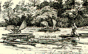
Shad population
There has been a problem with declines in the shad population as early as the turn of the century. Traditionally, it was caught along with salmonSalmon
Salmon is the common name for several species of fish in the family Salmonidae. Several other fish in the same family are called trout; the difference is often said to be that salmon migrate and trout are resident, but this distinction does not strictly hold true...
in set nets which were suspended from poles driven into the river bed reasonably close to shore in tidal water.
Many of the rivers where it was common now suffer from pollution
Pollution
Pollution is the introduction of contaminants into a natural environment that causes instability, disorder, harm or discomfort to the ecosystem i.e. physical systems or living organisms. Pollution can take the form of chemical substances or energy, such as noise, heat or light...
; however, in some cases, the short length of time spent by shad in fresh water may minimize contamination. Shad are taken from the Hudson River
Hudson River
The Hudson is a river that flows from north to south through eastern New York. The highest official source is at Lake Tear of the Clouds, on the slopes of Mount Marcy in the Adirondack Mountains. The river itself officially begins in Henderson Lake in Newcomb, New York...
and eaten, as scientists have found that they are not in the river long enough to be affected by PCBs and other contaminants. Note: Fishing for (including catch and release) or possessing American Shad in the Hudson River
Hudson River
The Hudson is a river that flows from north to south through eastern New York. The highest official source is at Lake Tear of the Clouds, on the slopes of Mount Marcy in the Adirondack Mountains. The river itself officially begins in Henderson Lake in Newcomb, New York...
or Marine District is prohibited.
Such pollution, however, may damage the spawn, and studies have been undertaken to determine whether fingerlings suffer DNA
DNA
Deoxyribonucleic acid is a nucleic acid that contains the genetic instructions used in the development and functioning of all known living organisms . The DNA segments that carry this genetic information are called genes, but other DNA sequences have structural purposes, or are involved in...
damage. Some of the rivers in which the shad spawns have dams on them, eliminating much of the spawning grounds; in recent years, several small dams have been destroyed for just this reason. Pollutants, even if not harmful per se, may encourage the growth of unfriendly water fauna. And finally, shad have simply been overfished.
Even more important to the decline of the shad is the damming of the rivers and streams in which they spawn, as pregnant doe shad are quite heavy and do not jump even when hooked. As noted above, the number of shad caught in the Merrimack River declined from almost 900,000 in 1789 to 0 in 1888, due to the fishes' inability to reach their spawning ground.
Shad serve a peculiar symbolic role in Virginia
Virginia
The Commonwealth of Virginia , is a U.S. state on the Atlantic Coast of the Southern United States. Virginia is nicknamed the "Old Dominion" and sometimes the "Mother of Presidents" after the eight U.S. presidents born there...
state politics. On the year of every gubernatorial election, would-be candidates, lobbyists, campaign workers, and reporters gather in the town of Wakefield, Virginia
Wakefield, Virginia
Wakefield is an incorporated town in Sussex County, Virginia, United States. The population was 1,038 at the 2000 census.Wakefield is famous for being the "Peanut Capital of the World" and the location of the famous , as well as the site of Airfield Conference and 4-H Educational Center...
for Shad Planking
Shad Planking
The Shad Planking is an annual political event in Virginia which takes place every April near Wakefield in Sussex County. It is sponsored by a chapter of the Ruritans, a community service organization which was originally founded in the small town of Holland about 30 miles to the...
.
American Shad were introduced into the San Francisco Bay
San Francisco Bay
San Francisco Bay is a shallow, productive estuary through which water draining from approximately forty percent of California, flowing in the Sacramento and San Joaquin rivers from the Sierra Nevada mountains, enters the Pacific Ocean...
/Sacramento River system in California in the 1800s. Shad have spread throughout many river systems on the West Coast of North America. There is currently a very large shad population in the Columbia River. In recent years shad counts at Bonneville and The Dalles Dams have ranged from over two million to over five million fish per year. Shad return to the Columbia in May and June. Shad migrate upstream as far as above Lower Granite Dam on the Snake River and above Priest Rapids Dam on the Upper Columbia. Unlike many exotic/introduced species, it has not been confirmed that American Shad have serious negative effects on the environment or other native fish species in the Columbia.
Shad fishing
External links
- Video - American Shad Restoration: Gill Net Fishing on the Potomac River. [link appears to be broken - May 9}
- http://www.2011shadfestposters.blogspot.com Shad Festival, Lambertville, NJ.]
- Shad Roe recipe from "The Boston Cooking-school Cook Book" by Fannie Farmer, published in 1918.
- http://www.villagevoice.com/nyclife/0613,lalli,72659,15.html Village Voice article, "Shad Madness".
- http://www.newenglandshad.com New England Shad Association