

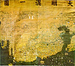
Da Ming Hun Yi Tu
Encyclopedia
Manchu language
Manchu is a Tungusic endangered language spoken in Northeast China; it used to be the language of the Manchu, though now most Manchus speak Mandarin Chinese and there are fewer than 70 native speakers of Manchu out of a total of nearly 10 million ethnic Manchus...
: dai ming gurun-i uherilehe nirugan) is a world map created in China
China
Chinese civilization may refer to:* China for more general discussion of the country.* Chinese culture* Greater China, the transnational community of ethnic Chinese.* History of China* Sinosphere, the area historically affected by Chinese culture...
. It was painted in colour on stiff silk and 386 x 456cm in size. The original text was written in Classical Chinese
Classical Chinese
Classical Chinese or Literary Chinese is a traditional style of written Chinese based on the grammar and vocabulary of ancient Chinese, making it different from any modern spoken form of Chinese...
, but Manchu
Manchu language
Manchu is a Tungusic endangered language spoken in Northeast China; it used to be the language of the Manchu, though now most Manchus speak Mandarin Chinese and there are fewer than 70 native speakers of Manchu out of a total of nearly 10 million ethnic Manchus...
labels were later superimposed on them.
It is one of the oldest surviving world maps from East Asia although the exact date of creation remains unknown. It depicts the general form of the Old World
Old World
The Old World consists of those parts of the world known to classical antiquity and the European Middle Ages. It is used in the context of, and contrast with, the "New World" ....
, placing China in the center and stretching northward to Mongolia
Mongolian Plateau
The Mongolian Plateau is part of the larger Central Asian Plateau and has an area of approximately 2,600,000 square kilometres. It is occupied by Mongolia in the north and Inner Mongolia in the south. The plateau includes the Gobi Desert as well as dry steppe regions...
, southward to Java
Java
Java is an island of Indonesia. With a population of 135 million , it is the world's most populous island, and one of the most densely populated regions in the world. It is home to 60% of Indonesia's population. The Indonesian capital city, Jakarta, is in west Java...
, eastward to central Japan
Japan
Japan is an island nation in East Asia. Located in the Pacific Ocean, it lies to the east of the Sea of Japan, China, North Korea, South Korea and Russia, stretching from the Sea of Okhotsk in the north to the East China Sea and Taiwan in the south...
, and westward to Africa
Africa
Africa is the world's second largest and second most populous continent, after Asia. At about 30.2 million km² including adjacent islands, it covers 6% of the Earth's total surface area and 20.4% of the total land area...
and Europe
Europe
Europe is, by convention, one of the world's seven continents. Comprising the westernmost peninsula of Eurasia, Europe is generally 'divided' from Asia to its east by the watershed divides of the Ural and Caucasus Mountains, the Ural River, the Caspian and Black Seas, and the waterways connecting...
.
History
Little is known about this world map. Its author is unknown and the date of creation is unclear. The map was created in China sometime during the Ming DynastyMing Dynasty
The Ming Dynasty, also Empire of the Great Ming, was the ruling dynasty of China from 1368 to 1644, following the collapse of the Mongol-led Yuan Dynasty. The Ming, "one of the greatest eras of orderly government and social stability in human history", was the last dynasty in China ruled by ethnic...
and handed over to the new rulers of China, the Manchu
Manchu
The Manchu people or Man are an ethnic minority of China who originated in Manchuria . During their rise in the 17th century, with the help of the Ming dynasty rebels , they came to power in China and founded the Qing Dynasty, which ruled China until the Xinhai Revolution of 1911, which...
s. It has been kept on the Imperial Palace and was called Qingzi Qian Yitong Tu (清字簽一統圖) in some catalogs. It is currently kept in protective storage at the First Historical Archive of China, in Beijing
Beijing
Beijing , also known as Peking , is the capital of the People's Republic of China and one of the most populous cities in the world, with a population of 19,612,368 as of 2010. The city is the country's political, cultural, and educational center, and home to the headquarters for most of China's...
. A full-sized digital replica was made for the South African government in 2002.
The place names of China on the map reflect the political situation in 1389, or the 22nd year of the reign of the Hongwu Emperor
Hongwu Emperor
The Hongwu Emperor , known variably by his given name Zhu Yuanzhang and by his temple name Taizu of Ming , was the founder and first emperor of the Ming Dynasty of China...
. Thus some Chinese scholars concluded that it was indeed created in 1389 or little later. Others maintain a cautious attitude, suggesting that what was revised in 1389 is probably a source map of the Da Ming Hun Yi Tu and that the Da Ming Hun Yi Tu itself was created much later.
In either case, it is certain that the Ming Dynasty created a map around 1389. Japanese scholar Miya Noriko speculated on the motivation behind it: Although the Hongwu Emperor, first of the Ming dynasty
Ming Dynasty
The Ming Dynasty, also Empire of the Great Ming, was the ruling dynasty of China from 1368 to 1644, following the collapse of the Mongol-led Yuan Dynasty. The Ming, "one of the greatest eras of orderly government and social stability in human history", was the last dynasty in China ruled by ethnic...
, drove the Mongol Yuan Dynasty
Yuan Dynasty
The Yuan Dynasty , or Great Yuan Empire was a ruling dynasty founded by the Mongol leader Kublai Khan, who ruled most of present-day China, all of modern Mongolia and its surrounding areas, lasting officially from 1271 to 1368. It is considered both as a division of the Mongol Empire and as an...
out of China in 1368, Mongols maintained military power that posed a real threat to the new dynasty. The situation was changed in 1388 when Uskhal Khan
Uskhal Khan
Uskhal Khan , born Tögüs Temür , was a Mongol Emperor of the Northern Yuan Dynasty in Mongolia. He was the last powerful khan of the Mongols until the reign of Dayan Khan....
of Northern Yuan was killed and the Khubilaid line of succession was terminated. The Ming Dynasty may have celebrated this historic event by creating a new map.
Relationship to other maps
Maps had for centuries played an important role in the government of such a vast country, and surviving examples on stoneChinese geography
Native Chinese geography begins in the Warring States period . It expands its scope beyond the Chinese homeland with the growth of the Chinese Empire under the Han Dynasty...
dating from AD 1137 but based on much earlier surveys, show great accuracy, using a grid system. By then the Chinese had also developed the magnetic compass
Compass
A compass is a navigational instrument that shows directions in a frame of reference that is stationary relative to the surface of the earth. The frame of reference defines the four cardinal directions – north, south, east, and west. Intermediate directions are also defined...
, and in the 13th century western versions of that device allowed European cartography, almost abandoned after the fall of the western Roman Empire
Roman Empire
The Roman Empire was the post-Republican period of the ancient Roman civilization, characterised by an autocratic form of government and large territorial holdings in Europe and around the Mediterranean....
, to catch up with Chinese standards of accuracy.
By the early years of the 14th century, when Mongol domination
Mongol Empire
The Mongol Empire , initially named as Greater Mongol State was a great empire during the 13th and 14th centuries...
over much of Eurasia
Eurasia
Eurasia is a continent or supercontinent comprising the traditional continents of Europe and Asia ; covering about 52,990,000 km2 or about 10.6% of the Earth's surface located primarily in the eastern and northern hemispheres...
created favourable conditions for east-west communication, Islamic maps of Europe and Africa had found its way to China, encouraging Chinese cartographers to create world maps incorporating the new information.
Scholars consider that the Da Ming Hun Yi Tu was ultimately based on a now lost world map named Shengjiao Guangbei Tu (聲教廣被圖). It was created by Li Zemin during the Mongol Yuan Dynasty. Other extant maps considered to be based on Li's map are some copies of the Kangnido (1402) and a pair of maps named Dongnan Haiyi Tu (東南海夷圖) and Xinan Haiyi Tu (西南海夷圖), which is recorded in the Guang Yu Tu (廣與圖)(1555) by Luo Hongxian (羅洪先). Comparative studies of these extant maps are conducted to restore the content of Li's original world map. The Da Ming Hun Yi Tu is especially important because Luo's copies dropped most place names except for coastal areas and islands and because the Kangnido was influenced by Korean cartography.
Compared to the Kangnido, the Da Ming Hun Yi Tu provides more detailed information on Mongolia and Central Asia and India. In Manchuria, Changbai Mountain, where the foundation myth of the Manchu Aisin Gioro
Aisin Gioro
Aisin Gioro was the family name of the Manchu emperors of the Qing Dynasty. The House of Aisin Gioro ruled China until the Xinhai Revolution of 1911, which established a republican government in its place. The word aisin means gold in the Manchu language, and "gioro" is the name of the place in...
imperial family was set, is overly portrayed. It presents India as a peninsula while it sinks into the "Chinese continent" on the Kangnido. It is presumed that India was portrayed as a peninsula on Li's map but shrunk by Korean Confucians due to their anti-Buddhist policy. Africa and Arabia on the Da Ming Hun Yi Tu resemble those on the Kangnido while Europe is considerably different. It is also distinct from the Kangnido in the depiction of the source of the Yellow River, which looks very similar to that in Luo's Guang Yu Tu.
Content
The Earth's curvature affects even the scale of the Chinese section of the map. Horizontally, it works out at about 1:820,000; but vertically it is around 1:1,060,000. The use of colour is particularly effective within China itself, including elegant touches like the ochre tint of the Huang He (Yellow River).It replicates the curvature of the Earth by compression of areas farthest away from China (most obviously the extreme horizontal squeeze of Europe), their reduced size making both a geographical and a political statement. Outside China, sub-Saharan Africa is depicted in a good approximation of the correct shape, complete with mountains near the southern tip. The interior of the continent is extraordinary: a river with twin sources (the common depiction in Classical and Islamic maps of the Nile) starts in the south of the continent, but enters the Red Sea, while the Nile, contrary to the information in non-Chinese maps of the era (though in conformity with a reported Arab geographical legend that "farther south from the Sahara Desert is a great lake, far greater than the Caspian Sea
Caspian Sea
The Caspian Sea is the largest enclosed body of water on Earth by area, variously classed as the world's largest lake or a full-fledged sea. The sea has a surface area of and a volume of...
") has its source in a vast inland sea. This is likely to be based on vague information about the several great lakes
African Great Lakes
The African Great Lakes are a series of lakes and the Rift Valley lakes in and around the geographic Great Rift Valley formed by the action of the tectonic East African Rift on the continent of Africa...
in the region of modern Tanzania
Tanzania
The United Republic of Tanzania is a country in East Africa bordered by Kenya and Uganda to the north, Rwanda, Burundi, and the Democratic Republic of the Congo to the west, and Zambia, Malawi, and Mozambique to the south. The country's eastern borders lie on the Indian Ocean.Tanzania is a state...
, gained during the course of direct trade between China and south-east Africa.
Black Sea
The Black Sea is bounded by Europe, Anatolia and the Caucasus and is ultimately connected to the Atlantic Ocean via the Mediterranean and the Aegean seas and various straits. The Bosphorus strait connects it to the Sea of Marmara, and the strait of the Dardanelles connects that sea to the Aegean...
areas. Unlike the African lake, those seas are not shaded with wave symbols, and nor is the nearby Caspian Sea, mapped in Islamic style with two islands, suggesting that the whole area is based on a single Islamic map. Arabia is squeezed horizontally, but recognisable. The prominent peninsula on the west coast of the Chinese landmass is Malaysia
Malay Peninsula
The Malay Peninsula or Thai-Malay Peninsula is a peninsula in Southeast Asia. The land mass runs approximately north-south and, at its terminus, is the southern-most point of the Asian mainland...
, but India is represented merely as a collection of place-names north-west of Arabia. Another manifestation of the same problem, dependence on external sources for geographical information, can be seen to the south of Korea, at the far right side of the map, where Japan, over-sized and misshapen, confusingly meets the much more correctly sized and positioned Taiwan
Taiwan
Taiwan , also known, especially in the past, as Formosa , is the largest island of the same-named island group of East Asia in the western Pacific Ocean and located off the southeastern coast of mainland China. The island forms over 99% of the current territory of the Republic of China following...
.
External links
- Chinese cartography website by Qiming Zhou, Hong Kong Baptist University- accessed 2008-03-16