
Chinese geography
Encyclopedia

China
Chinese civilization may refer to:* China for more general discussion of the country.* Chinese culture* Greater China, the transnational community of ethnic Chinese.* History of China* Sinosphere, the area historically affected by Chinese culture...
geography begins in the Warring States period (5th century BC). It expands its scope beyond the Chinese homeland with the growth of the Chinese Empire
Early Imperial China
Early Imperial China begins in the Iron Age with the unification of China by the Qin dynasty in 221 BC. It ended five centuries of feudal warfare, similar to that of Western Europe, that plagued the Eastern Zhou dynasty. The short-lived Qin introduced centralized government under the absolute...
under the Han Dynasty
Han Dynasty
The Han Dynasty was the second imperial dynasty of China, preceded by the Qin Dynasty and succeeded by the Three Kingdoms . It was founded by the rebel leader Liu Bang, known posthumously as Emperor Gaozu of Han. It was briefly interrupted by the Xin Dynasty of the former regent Wang Mang...
. It enters its golden age with the invention of the compass
Compass
A compass is a navigational instrument that shows directions in a frame of reference that is stationary relative to the surface of the earth. The frame of reference defines the four cardinal directions – north, south, east, and west. Intermediate directions are also defined...
in the 11th century (Song Dynasty
Song Dynasty
The Song Dynasty was a ruling dynasty in China between 960 and 1279; it succeeded the Five Dynasties and Ten Kingdoms Period, and was followed by the Yuan Dynasty. It was the first government in world history to issue banknotes or paper money, and the first Chinese government to establish a...
) and peaks with 15th century (Ming Dynasty
Ming Dynasty
The Ming Dynasty, also Empire of the Great Ming, was the ruling dynasty of China from 1368 to 1644, following the collapse of the Mongol-led Yuan Dynasty. The Ming, "one of the greatest eras of orderly government and social stability in human history", was the last dynasty in China ruled by ethnic...
) Chinese exploration
Chinese exploration
Chinese exploration includes exploratory Chinese travels abroad, on land and by sea, from the 2nd century BC until the 15th century.-Pamir Mountains and beyond:...
of the Pacific under admiral Zheng He
Zheng He
Zheng He , also known as Ma Sanbao and Hajji Mahmud Shamsuddin was a Hui-Chinese mariner, explorer, diplomat and fleet admiral, who commanded voyages to Southeast Asia, South Asia, the Middle East, and East Africa, collectively referred to as the Voyages of Zheng He or Voyages of Cheng Ho from...
.
Highlights
Warring States- Seven Qin State maps dated to the 4th century BC are found in Gansu province in 1986
- Crown Prince Dan of YanCrown Prince Dan of YanCrown Prince Dan of Yan was a crown prince of the state of Yan during the Warring States Period in China. Originally a hostage in the State of Qin, he was sent back to Yan in 232 BC. He sent Jing Ke to assassinate Qin Shi Huang, then Emperor of China, but he failed...
and Jing KeJing KeJing Ke was a guest residing in the estates of Dan, crown prince of Yan and renowned for his failed assassination attempt of Ying Zheng, King of Qin state, who later became China's first emperor...
's assassination plot against Qin Shi HuangQin Shi HuangQin Shi Huang , personal name Ying Zheng , was king of the Chinese State of Qin from 246 BC to 221 BC during the Warring States Period. He became the first emperor of a unified China in 221 BC...
in 227 BC, first reference to a map drawn on silk.
Han
- Mawangdui archeological site reveals three maps drawn on silk, dated to the 2nd century BC, found in 1973
- Book of HanBook of HanThe Book of Han, Hanshu or History of the Former Han Dynasty |Fan Ye]] . Various scholars have estimated that the earliest material covered in the book dates back to between 206 and 202 BCE...
- Rites of ZhouRites of ZhouThe Rites of Zhou , also known as Zhouguan, is one of three ancient ritual texts listed among the classics of Confucianism. It was later renamed Zhouli by Liu Xin to differentiate it from a chapter in the Classic of History which was also known as Zhouguan.Though tradition ascribed the text of the...
- Liu AnLiu AnLíu Ān was a Chinese prince and advisor to his nephew, Emperor Wu of Han of the Han Dynasty in China and the legendary inventor of t'ai chi...
(2nd century BC), HuainanziHuainanziThe Huáinánzǐ is a 2nd century BCE Chinese philosophical classic from the Han dynasty that blends Daoist, Confucianist, and Legalist concepts, including theories such as Yin-Yang and the Five Phases. It was written under the patronage of Liu An, Prince of Huainan, a legendarily prodigious author... - Yuejue Shu, the first gazetteerGazetteerA gazetteer is a geographical dictionary or directory, an important reference for information about places and place names , used in conjunction with a map or a full atlas. It typically contains information concerning the geographical makeup of a country, region, or continent as well as the social...
in China, written in 52 CE.
Three Kingdoms
- Pei XiuPei XiuPei Xiu , style name Jiyan , was a minister, geographer, and cartographer of the state of Cao Wei during the Three Kingdoms period of Chinese history, as well as the subsequent Jin Dynasty. Pei Xiu was very much trusted by Sima Zhao, and participated in the suppression of Zhuge Dan's coup...
(3rd century), the "father of Chinese cartography" produced a map of China with plotted grid lines and a graduated scaleGrid referenceGrid references define locations on maps using Cartesian coordinates. Grid lines on maps define the coordinate system, and are numbered to provide a unique reference to features....
.
Tang
- BianjiBianjiBianji was a Chinese Buddhist monk, translator and the author of Great Tang Records on the Western Regions lived during the Tang Dynasty. Little is known about his life, he was a translator of several Buddhist scriptures and sutras before he was executed by Emperor Taizong, who was angry about his...
(7th century), Great Tang Records on the Western RegionsGreat Tang Records on the Western RegionsThe Great Tang Records on the Western Regions is a narrative of Xuanzang's nineteen year journey through Chang'an to Central Asia and eventually South Asia between 626 and 645... - Jia DanJia DanJia Dan , courtesy name Dunshi , formally Duke Yuanjing of Wei , was a Chinese scholar-official, general, geographer, and cartographer from Cangzhou, Hebei during the Tang Dynasty of China.- Background :...
(8th century) - Duan ChengshiDuan ChengshiDuan Chengshi was an author and scholar of the Tang Dynasty in China. He was born to a wealthy family in present day Zibo, Shandong. A descendant of the early Tang official Duan Zhixuan 段志玄 , and the son of Duan Wenchang 段文昌, a high official under Tang Xuanzong, his family background enabled him...
(9th century)
Song
- Su SongSu SongSu Song was a renowned Chinese polymath who specialized himself as a statesman, astronomer, cartographer, horologist, pharmacologist, mineralogist, zoologist, botanist, mechanical and architectural engineer, poet, antiquarian, and ambassador of the Song Dynasty .Su Song was the engineer of a...
(11th century) - Shen KuoShen KuoShen Kuo or Shen Gua , style name Cunzhong and pseudonym Mengqi Weng , was a polymathic Chinese scientist and statesman of the Song Dynasty...
(11th century) - Fan ChengdaFan ChengdaFan Chengda , courtesy name Zhineng , was one of the best-known Chinese poets of the Song Dynasty , a government official, and an academic authority in geography , especially the southern provinces of China...
(12th century)
Yuan
- Zhou DaguanZhou DaguanZhou Daguan was a Chinese diplomat under the Temür Khan, Emperor Chengzong of Yuan. He is most well known for his accounts of the customs of Cambodia and the Angkor temple complexes during his visit there. He arrived at Angkor in August 1296, and remained at the court of King Indravarman III...
(13th century) - Wang DayuanWang DayuanWang Dayuan was a traveller from Quanzhou, China during the Yuan Dynasty in the 14th century. He made two major trips on ships. During 1328-1333, he sailed along the South China Sea and visited many places in Southeast Asia and reached as far as South Asia, landing in Sri Lanka and India...
(14th century) - Yu QinYu QinYu Qin was a well-known Chinese geographer living in the Yuan Dynasty. In 1319 AD, he was appointed the official of Jinan to resolve the starvation problem caused by bad harvesting. He started to write the famous geography book Qi Cheng during this period, which was the oldest known geography...
(14th century)
Ming
- Zheng HeZheng HeZheng He , also known as Ma Sanbao and Hajji Mahmud Shamsuddin was a Hui-Chinese mariner, explorer, diplomat and fleet admiral, who commanded voyages to Southeast Asia, South Asia, the Middle East, and East Africa, collectively referred to as the Voyages of Zheng He or Voyages of Cheng Ho from...
(15th century) - Xu XiakeXu XiakeXu Xiake , born Xu Hongzu , courtesy name Zhenzhi , was a Chinese travel writer and geographer of the Ming Dynasty known best for his famous geographical treatise, and noted for his bravery and humility. He traveled throughout China for more than 30 years, documenting his travels extensively...
(17th century) - Matteo RicciMatteo RicciMatteo Ricci, SJ was an Italian Jesuit priest, and one of the founding figures of the Jesuit China Mission, as it existed in the 17th-18th centuries. His current title is Servant of God....
and Xu GuangqiXu GuangqiXu Guangqi , was a Chinese scholar-bureaucrat, agricultural scientist, astronomer, and mathematician in the Ming Dynasty. Xu was a colleague and collaborator of the Italian Jesuits Matteo Ricci and Sabatino de Ursis and they translated several classic Western texts into Chinese, including part of...
(17th century) - Giulio Aleni (1623)
- Martino MartiniMartino MartiniMartino Martini was an Italian Jesuit missionary, cartographer and historian, mainly working on ancient Imperial China.-Early years:Martini was born in Trento, in the Bishopric of Trent...
(1655)
Early survivals
Korea
Korea ) is an East Asian geographic region that is currently divided into two separate sovereign states — North Korea and South Korea. Located on the Korean Peninsula, Korea is bordered by the People's Republic of China to the northwest, Russia to the northeast, and is separated from Japan to the...
and Vietnam
Vietnam
Vietnam – sometimes spelled Viet Nam , officially the Socialist Republic of Vietnam – is the easternmost country on the Indochina Peninsula in Southeast Asia. It is bordered by China to the north, Laos to the northwest, Cambodia to the southwest, and the South China Sea –...
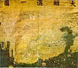
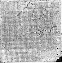
. On the reverse, the Yu Ji Tu (see picture), a copy of a more ancient map, uses the grid system developed in China a millennium earlier.
Maps of the Yuan Dynasty
The expansion of Chinese geographical enterprise to a world scale originates from a historical setting of the Mongol EmpireMongol Empire
The Mongol Empire , initially named as Greater Mongol State was a great empire during the 13th and 14th centuries...
, which connected the western Islamic world with the Chinese sphere, enabling both trade and the exchange of information.
After the founding of the Yuan Dynasty
Yuan Dynasty
The Yuan Dynasty , or Great Yuan Empire was a ruling dynasty founded by the Mongol leader Kublai Khan, who ruled most of present-day China, all of modern Mongolia and its surrounding areas, lasting officially from 1271 to 1368. It is considered both as a division of the Mongol Empire and as an...
in 1271, Kublai Khan
Kublai Khan
Kublai Khan , born Kublai and also known by the temple name Shizu , was the fifth Great Khan of the Mongol Empire from 1260 to 1294 and the founder of the Yuan Dynasty in China...
ordered the compilation of a geography monograph named Dayuan Dayitong Zhi (大元大一統志) (extant manuscripts lack maps) in 1285. In 1286, Persian astronomer Jamāl al-Dīn
Jamal ad-Din (astronomer)
Jamal ad-Din Muḥammad ibn Ṭāhir ibn Muḥammad al‐Zaydī al‐Bukhārī was a 13th-century Persian-speaking Muslim astronomer...
made Kublai Khan (who had brought him east to undertake co-operative research with Chinese scholars in the 1260s) a proposal for merging several maps of the empire into a single world map, and it resulted in the Tianxia Dili Zongtu (天下地理總圖). It was supposedly a world map but is lost today. He also ordered to obtain a book called Rāh-nāmah (road book) from Muslim sailors. An extant map attached to the Jingshi Dadian (經世大典; 1329-1333) proves Mongols' accurate knowledge on Inner Asia that was obtained from Muslims. Influence by these official projects, Taoist monk Zhu Siben (朱思本) complied a geography monograph of China named Jiuyu Zhi (九域志) in 1297. Based on this earlier work, he created a now lost map of China named Yuditu (與地圖) in 1311-1320.
These materials were, however, too large for circulation. What directly impacted Chinese intellectuals were the secondary compilations. In the first half of the 14th century, encyclopedias such as the Hanmo Quanshu (翰墨全書) and the Zhishun edition of the Shilin Guangji (事林廣記) updated their geographic knowledge from the preceding Jurchen Jin and Southern Song Dynasties to the contemporary Mongol-ruled Yuan Dynasty.
Newly discovered materials reveal personal networks among intellectuals of southern China, centered in Qingyuan (Ningbo
Ningbo
Ningbo is a seaport city of northeastern Zhejiang province, Eastern China. Holding sub-provincial administrative status, the municipality has a population of 7,605,700 inhabitants at the 2010 census whom 3,089,180 in the built up area made of 6 urban districts. It lies south of the Hangzhou Bay,...
). Qingjun, who was from neighboring Taizhou, created the Hunyi Jiangli Tu when he stayed in Qingyuan. Wu Sidao, who left an important bibliographic clue, was also from Qingyuan. In addition, Ningbo was one of the most important seaports and the sea routes were extended to Fuzhou and Guangzhou, and Southeast Asia, Japan and Goryeo. They must have acquired marine information from Muslim sailors.
Maps in the Chinese tradition tended to be known by specific titles, easily expressed as short sequences of ideograms, such as the Yu Gong Jiuzhou Lidai Diwang Guodu Dili Tu (禹貢九州歷代帝王國都地理圖; Map of Capitals of Historical Emperors and Kings in the Nine Provinces
Jiuzhou
The Nine Provinces is a term used in ancient Chinese histories to refer to territorial divisions during the Xia and Shang dynasties, and has now come to symbolically represent China. "Province" is the term used to translate zhou since before the Tang Dynasty , a zhou was equivalent to a province...
of the Yu
Yu the Great
Yu the Great , was a legendary ruler of Ancient China famed for his introduction of flood control, inaugurating dynastic rule in China by founding the Xia Dynasty, and for his upright moral character....
Gong).
Shengjiao Guangbei Tu
The Shengjiao Guangbei Tu ("map of the resounding teaching (of the khan) prevailing all over the world") by Li Zemin is lost. Its original state can be deduced by examining its derivative works: the Guangyutu (廣與圖)(1555) by Luo Hongxian (羅洪先) contains a pair of maps named Dongnan Haiyi Tu (東南海夷圖) and Xinan Haiyi Tu (西南海夷圖) that are considered to be the southern half of the Shengjiao Guangbei Tu although Luo's copy dropped most place names except for coastal areas and islands. The Da Ming Hun Yi TuDa Ming Hun Yi Tu
The Great Ming Amalgamated Map or Da Ming Hun Yi Tu is a world map created in China. It was painted in colour on stiff silk and 386 x 456cm in size. The original text was written in Classical Chinese, but Manchu labels were later superimposed on them....
(大明混一圖/Dai Ming gurun-i uherilehe nirugan), a Ming period map with much later Manchu translations of its labels, is also considered to have been based ultimately on Li Zemin's map.
The Shengjiao Guangbei Tu was a world map. It contained not only China but also Africa and Europe. Luo's copy and the Daming Hunyi Tu suggest that the original depicted India more accurately than the Korean adaptation although it is also possible that the Daming Hunyi Tu reflects 17th century knowledge.
Little is known about the author Li Zemin. Based on place names on the map, it has been presumed that it was created around 1319 and revised sometime between 1329 and 1338. However, Wu Sidao's statement (described later) suggests that his map was newer than Qingjun's (1360?).
Guanglun Jiangli Tu
The Hunyi Jiangli Tu by Zen monk Qingjun (1328-1392) is lost. However, the Shuidong Riji (水東日記) by the Ming period book collector Ye Sheng (葉盛) (1420-1474) includes a modified edition of the map by the name of Guanglun Jiangli Tu (廣輪疆理圖). Ye Sheng also recorded Yan Jie (嚴節)'s colophon to the map (1452). According to Yan Jie, the Guanglun Jiangli Tu was created in 1360. The extant map was modified, probably by Yan Jie, to catch up with contemporary Ming place names. The original map covered place names of the Mongol-ruled Yuan Dynasty.The Guanglun Jiangli Tu was one of historical maps that were popular among Chinese intellectuals. It showed historical capitals of Chinese dynasties in addition to contemporary place names. It followed Chinese tradition in that it was a map of China, not the world. But contrary to Song period
Song Dynasty
The Song Dynasty was a ruling dynasty in China between 960 and 1279; it succeeded the Five Dynasties and Ten Kingdoms Period, and was followed by the Yuan Dynasty. It was the first government in world history to issue banknotes or paper money, and the first Chinese government to establish a...
maps which reflected limited Chinese knowledge on geography, it incorporated information on Mongolia and Southeast Asia. It also provided information of sea routes (There remain traces on the Honmyōji map).
Wu Sidao's work
Contemporary to Qingjun, Wu Sidao (烏斯道), author of Chuncaozhai Ji (春草齋集), merged the Guanglun Tu (廣輪圖) and Li Rulin (李汝霖)'s Shengjiao Beihua Tu (聲教被化圖) although his map is not known today. The Guanglun Tu must refer to Qingjun's Guanglun Jiangli Tu. It is likely that Rulin was Li Zemin's courtesy name and that Shengjiao Beihua Tu was an alias for his Shengjiao Guangbei Tu.Late maps in the Chinese tradition
In 1579, Luo Hongxian published the Guang Yutu atlas, including more than 40 maps, a grid system, and a systematic way of representing major landmarks such as mountains, rivers, roads and borders. The Guang Yutu incorporates the discoveries of naval explorer Zheng HeZheng He
Zheng He , also known as Ma Sanbao and Hajji Mahmud Shamsuddin was a Hui-Chinese mariner, explorer, diplomat and fleet admiral, who commanded voyages to Southeast Asia, South Asia, the Middle East, and East Africa, collectively referred to as the Voyages of Zheng He or Voyages of Cheng Ho from...
's 15th century voyages along the coasts of China, Southeast Asia, India and Africa.
From the 16th and 17th centuries, several examples survive of maps focused on cultural information. Gridlines are not used on either Yu Shi's Gujin xingsheng zhi tu (1555) or Zhang Huang's Tushu bian (1613); instead, illustrations and annotations show mythical places, exotic foreign peoples, administrative changes and the deeds of historic and legendary heroes.
See also
- History of geographyHistory of geographyThe history of geography includes various histories of geography which have differed over time and between different cultural and political groups. In more recent developments, geography has become a distinct academic discipline. 'Geography' derives from the from Greek - geographia,, a literal...
- History of cartographyHistory of cartographyCartography , or mapmaking, has been an integral part of the human story for a long time, possibly up to 8,000 years...
- Muslim geography
- Chinese explorationChinese explorationChinese exploration includes exploratory Chinese travels abroad, on land and by sea, from the 2nd century BC until the 15th century.-Pamir Mountains and beyond:...
- Kangnido
- 1421 hypothesis