
Kaiserstuhl
Encyclopedia
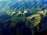
The „Kaiserstuhl“ is a relatively low mountain range – a Mittelgebirge – with a maximal height of 556.6 m above sea level. It is of volcanic origin and located in the South West of Baden-Württemberg, Germany in the districts of Emmendingen
and Breisgau-Hochschwarzwald
. In terms of natural regions it is considered part of the Upper Rhine Plain.
, mainly in Breisgau-Hochschwarzwald
district
. However, the smaller northern part belongs to Emmendingen district
.
Within the Upper Rhine Plain
it is situated about 16 km northwest of the city of Freiburg, right next to the eastern bank of the Rhine and a short distance west of the Dreisam
. It reaches up to 377 m above the level of the Rhine downstreams (179.5 m a.s.l.) from the weir
close to Burkheim.
At its utmost spread from the Michaelsberg close to Riegel
in the northeast to the Fohrenberg close to Ihringen
in the southwest, the Kaiserstuhl is about 15 km long. Its maximum width is about 12.5 km.
The subvolcanic rocks and lode rocks of the central Kaiserstuhl, on the contrary, are plutonic equivalents of the erupted material (essexite, carbonatite and coarse granular phonolite). For different varieties of the ode rocks several terms can be found, some of which have not been acknowledged. Of big scientific interest is the consolidated carbonatite neat Altvogtsburg und Schelingen. It is a quite rare volcanic rock, which through crystallization originated from a carbonite magamatic melt, not a silicate one. Due to this extraordinary situation the magmatic nature of the carbonatite has not been realized for a long time or put into doubt. Alternative interpretations suggested it was a metamorphologically altered sedimentary (rock which had undergone metamorphosis); examples of which can be found nearby. Only in the 1950s and 1960s researches succeeded in giving proof of it being a carbonite; one of the clues were the eruptive carbonatites found in the Western part of the Kaiserstuhl. Containing the Niob-mineral Koppit, experiments to retrieve the carbonatite rock by mining were carried out in the middle of the 20th century. However, the amount turned out to be too small for using them more intensely.
The higher the place of sedimentation the thinner is the layer of the actually sedimented material. At the Kaiserstuhl the thickness of the loess layer varies between 10 and 40 metres. There are, however, also areas in the Southwest, where no loess has been sedimented. The Northern Limestone Alps are considered the main source of the Kaiserstuhl loess. To be noted is a rust-coloured band occurring at irregular intervals. It developed as new material did not arrive regularly but in phases of different intensity. In a phase of weak sedimentation the material on top weathers – and the calcium carbonate is washed out. It then precipitates further down and forms a particular type of soil horizon, which contains concretions of calcium carbonate. Thus, if there is a soil horizon in which washing out takes place, there must be a correspondent one, in which the material is then precipitated.
The Kaiserstuhl loess soils are used for intensive farming, as they offer good areation, high water storage capacities and good mechanical qualities. Besides, as a result of farming deep narrow ravine-like paths developed.
As the loess developed over time it is, furthermore, significant for flood control. Sponge-like it absorbes and steadily releases rainfalls. This quality is, however, lost, as bulldozers, used to build large terraces for viniculture, compress the loess.
and fauna
. The Kaiserstuhl is for example one of the places with the largest variety of orchids in Europe - more than 30 species have been registered. Among the vines wild grape hyacinth
s sprawl and along acclivities iris plants blossom. Furthermore sand lizard
s (lacerta bilineata) and praying mantis (Mantis religiosa)live here - species which mainly occur in the Mediterranean area. (However, according to the latest research results the sand lizard presumably belongs to the allochthone species of the European green lizard
(Lacerta viridis)). The pubescent oak (Quercus pubescens)is a xerophyt and normally only occurs in Southern Europe
, but is also able to survive at the Kaiserstuhl. This species lives in a disjunctive area, which means away from its normal habitat. It is a relict of a postglacial warm period where there had been a much warmer climate around the Kaiserstuhl. After the end of the warm period only the named species were able to survive. Besides there is a larger population of the May beetle (Melolontha melolontha). In spite of protests of conservationists the May Beetle is battled against by means of insecticide
s.
Varietals grown in the Kaiserstuhl: Müller-Thurgau
, Riesling
, Silvaner
, Ruländer, Blue Spätburgunder, Grauburgunder, Weißer Burgunder, Gewürztraminer
.
To start with, it was for this reason that smaller terraces were merged in around 1950, this resulted in large reallocation, which turned parts of the original landscape completely upside down.
The phases of this reallocation begun with
From the year 1977 on, several longer periods of great precipitation caused damages to the embankments. During one week in May 1983 the amount of precipitation was so large, that in some areas it made one third of the annual average, causing great damages in the modified areas.
The surfaces of the acclivities often slid off together with the vegetation. Former valleys, which had been blocked out caused by re-allocation, were flushed out. In some terraces dramatic shear failures developed. Additionally there occurred to some extent devastating frost damages. Caused by the decline of the mountainside of the surfaces of the acclivities cold air pockets were formed in which the vines mainly in bloom were bitten. Additionally substantial damages by frost arose at the wood of the vines, especially in the vineyards which were situated in lower regions. In earlier times mostly fruit had been grown here but later is was used for wine-growing.
The activity of the farmland consolidation authority was narrowed to repairing and partly to re-scheduling which at least was meant to correct the most severe consequences of the transformations from 1982 on.
. Major local roads are L113 that links A5
, the north side of the area and the french border; and B31 which connects the southside of the area with the french border, A5 and Freiburg i.B.
The area is also served by Breisgau S-Bahn
. On the east side, the north side and the west side the Kaiserstuhlbahn passes and on the south side the Breisacher Bahn.
, the Upper Rhine Valley]] and the Vosges
from the trail.
2007 eight trails with special topics were opened. They have a total length of 140 km and were integrated into the already existing trail network (check mark: yellow rhomb on white background) of the Black Forest Society. In doing so the network was provided with 430 new sign posts.Large boards with an overview map and with site information are placed at central points, for example in train stations, which the trails join onto or through built up areas. Every trail is categorised by its own colour and the names have a corresponding symbol displayed on the entrance portals and the signposts. A further 120 smaller themed paths illustrate local specialities along the way. Local paths such as the Brunnenpfad (7 km) in Bötzingen
were integrated into the new network of the themed paths.
2010 the Kaiserstuhlpfad was added to the eight trails with special topics. This trail got a seal of quality called "Qualitätswanderweg Wunderbares Deutschland". The trail, which has a length of 21,7 km, was adapted to the Neunlindenpfad (North-South-trail) and leads from Endingen through the Ehrle Valley to the Katharinenkapelle (St. Catherine's Chapel), across the Badberge (Bad Mountains) to the Eichelspitzturm, onward across the Vogelsang Pass to the Neunlindenturm (Neunlinden Tower), through the Eichgasse to Bickensohl and across the Kreuzbuck through the Lenzengasse to Ihringen.
Emmendingen
Emmendingen is a town in Baden-Württemberg, capital of the district Emmendingen of Germany. It is located at the Elz River, north of Freiburg im Breisgau...
and Breisgau-Hochschwarzwald
Breisgau-Hochschwarzwald
Breisgau-Hochschwarzwald is a district in the south of Baden-Württemberg, Germany. Neighboring districts are Emmendingen, Schwarzwald-Baar, Waldshut, Lörrach and the French départements of the Haut-Rhin and the Bas-Rhin. The district-free city of Freiburg is surrounded by the district...
. In terms of natural regions it is considered part of the Upper Rhine Plain.
Name
The name "Kaiserstuhl" is believed to refer to King Otto III, who held court near Sasbach on December 22, 994. Since then the whole mountain range was called “Königsstuhl” – the King’s chair. In May 996 Otto III was crowned Emperor and the King’s chair became the Emperor’s chair – “Kaiserstuhl”. Reliable sources mention the name “Kaiserstuhl” only as early as 1304. Historians thus suppose that the term “Kaiserstuhl” was not coined until the 13th century.Location
The Kaiserstuhl is situated in South BadenBaden
Baden is a historical state on the east bank of the Rhine in the southwest of Germany, now the western part of the Baden-Württemberg of Germany....
, mainly in Breisgau-Hochschwarzwald
Breisgau-Hochschwarzwald
Breisgau-Hochschwarzwald is a district in the south of Baden-Württemberg, Germany. Neighboring districts are Emmendingen, Schwarzwald-Baar, Waldshut, Lörrach and the French départements of the Haut-Rhin and the Bas-Rhin. The district-free city of Freiburg is surrounded by the district...
district
Districts of Germany
The districts of Germany are known as , except in the states of North Rhine-Westphalia and Schleswig-Holstein where they are known simply as ....
. However, the smaller northern part belongs to Emmendingen district
Districts of Germany
The districts of Germany are known as , except in the states of North Rhine-Westphalia and Schleswig-Holstein where they are known simply as ....
.
Within the Upper Rhine Plain
Upper Rhine Plain
The Upper Rhine Plain, Rhine Rift Valley or Upper Rhine Graben is a major rift, straddling the border between France and Germany. It forms part of the European Cenozoic Rift System, which extends across central Europe...
it is situated about 16 km northwest of the city of Freiburg, right next to the eastern bank of the Rhine and a short distance west of the Dreisam
Dreisam
Dreisam is a river in Germany near Freiburg. It empties into the Elz. The waters of the Dreisam feed the famous Freiburg bächle....
. It reaches up to 377 m above the level of the Rhine downstreams (179.5 m a.s.l.) from the weir
Weir
A weir is a small overflow dam used to alter the flow characteristics of a river or stream. In most cases weirs take the form of a barrier across the river that causes water to pool behind the structure , but allows water to flow over the top...
close to Burkheim.
At its utmost spread from the Michaelsberg close to Riegel
Riegel am Kaiserstuhl
Riegel am Kaiserstuhl is a German municipality in the district of Emmendingen in Baden-Württemberg. It is accessed by the motorway A5 .-Education:...
in the northeast to the Fohrenberg close to Ihringen
Ihringen
Ihringen is a town in the district of Breisgau-Hochschwarzwald in Baden-Württemberg in Germany....
in the southwest, the Kaiserstuhl is about 15 km long. Its maximum width is about 12.5 km.
Mountains
Some of the Kaiserstuhl's mountains and elevations and their sub-ranges (sorted by height in meters above sea level):- Totenkopf (556.6 m), 1.9 km east of Bickensohl; with telecommunication tower Vogtsburg 1 and observation tower Neunlinden
- Eichelspitze (521.3 m), 2.8 km northwest of BötzingenBötzingenBötzingen is a municipality in the Breisgau-Hochschwarzwald district, Baden-Württemberg, Germany....
- Katharinenberg (492.4 m), 1.3 km southeast of Amoltern
- Bisamberg (469.0 m), 1.2 km south of Amoltern
- Staffelberg (446.0 m), 1.5 km northwest of Schelingen
- Badberg (432.7 m) (protected area), 1.5 km east of Oberbergen
- Holzeck (431.9 m), 1.7 km northeast of IhringenIhringenIhringen is a town in the district of Breisgau-Hochschwarzwald in Baden-Württemberg in Germany....
; with tower - Hochbuck (374.8 m), 900 m south of AchkarrenAchkarrenAchkarren is part of the town of "Vogtsburg im Kaiserstuhl", a small town in Germany, and is located in the southernmost part of the town. It also borders the town of Ihringen. The valley of Achkarren faces west and is 5 km from the Rhine river and 7 km from Breisach...
- Schlossberg (352.1 m), 500 m northwest of Achkarren; with castle ruin Höhingen
- Böselsberg (340.1 m), 500 m northwest of Wasenweiler
- Büchsenberg (283.7 m), 1.3 km west of Achkarren
Localities
Towns and municipalities in and around the Kaiserstuhl (in alphabetical order):- Bahlingen
- BötzingenBötzingenBötzingen is a municipality in the Breisgau-Hochschwarzwald district, Baden-Württemberg, Germany....
- Breisach
- EichstettenEichstetten am KaiserstuhlEichstetten am Kaiserstuhl is a town in the district of Breisgau-Hochschwarzwald in Baden-Württemberg in Germany....
- Endingen with Amoltern, Kiechlinsbergen and Königschaffhausen
- IhringenIhringenIhringen is a town in the district of Breisgau-Hochschwarzwald in Baden-Württemberg in Germany....
with Wasenweiler - RiegelRiegel am KaiserstuhlRiegel am Kaiserstuhl is a German municipality in the district of Emmendingen in Baden-Württemberg. It is accessed by the motorway A5 .-Education:...
am Kaiserstuhl - SasbachSasbach am KaiserstuhlSasbach is a town in the district of Emmendingen in Baden-Württemberg in Germany. Sasbach is adjacent to the River Rhine and the Kaiserstuhl mountain. It is the location of two medieval castle ruins, Limburg and Sponeck....
with Jechtingen and Leiselheim - Vogtsburg with AchkarrenAchkarrenAchkarren is part of the town of "Vogtsburg im Kaiserstuhl", a small town in Germany, and is located in the southernmost part of the town. It also borders the town of Ihringen. The valley of Achkarren faces west and is 5 km from the Rhine river and 7 km from Breisach...
, Bickensohl, Bischoffingen, Burkheim, Oberbergen, Oberrotweil and Schelingen - Wyhl
Geology
The formation of the Kaiserstuhl volcano during the Tertiary was the climax and at the same time the end of volcanic activity in the Upper Rhine Valley Rift. Volcanic activity, of which we still see numerous, today heavily eroded volcanic vents, started as early as the Cretaceous. The Kaiserstuhl is the only larger volcano from this period in the rift valley. Geologically the Kaiserstuhl can be divided into two parts: the sedimentary and volcanic part. Due to these peculiarities the Kaiserstuhl has been labeled one of the most important national geotopes. (German award for geotopes)Sedimentary base
The horizontal sedimentary layers forming the Eastern third of the Kaiserstuhl date back to the Jurassic and the Tertiary long before the volcanic activity. Important stratigraphic outcrops are the Hauptrogenstein (local Oolite) which is found mainly near the village of Riegel and the Pechelbronner Schichten (local tertiary layers in the South-German Scarplands) near Bötzingen. During the formation of the Upper Rhine Plain this part of the Kaiserstuhl sloped less in respect to its surrounding area – and thus appears as a so-called horst. (wiki-link) As to its geological structure and the sequence of the escarpments the Kaiserstuhl is comparable to the nearby Tuniberg, Nimberg and also to the Schönberg, which is situated South of the City of Freiburg.Volcanic activity
Petrologically the volcanic Kaisersuhl is an alkali-carbonate rock formation. The volcanic rocks making up a large part of the central and Western Kaiserstuhl were the result of numerous volcanic eruptions during the Miocene, about 19 to 16 million years ago. They cover parts of the sedimentary base of the Eastern Kaiserstuhl, which is why in some places changes in the base’s mineralogical composition occurred. The driving force behind this process of contact metamorphism was an increase in temperature. Due to the alternate eruption of Tephra and lava flows from several vents a complex stratovolcano came into existence. Some of the rising magma solidified as volcanic intrusions bellow the surface - and today forms the central part of the Kaiserstuhl. Laterally rising phonolite magma also intruded into the sedimentary base of the Eastern Kaiserstuhl. Up to today several hundred meters of the original volcano have been eroded.Volcanic rocks
The entire volcanic Kaiserstuhl consists of stones that contain elements of foids and olivine and are not saturated with SiO2. Most igneous rocks on the surface are leucite-tephrites, subordinately also phonolites, limburgites, and olivine-nephelinites (at the Limbert Mountain near Sasbach). The latter of which is rich in xenotliths from the earth’s mantle. Regarding the igneous rocks carbonatite ignimtbrite and lapilli have to be mentioned as peculiarities. They can be found in places in the Western part of the Kaiserstuhl (Henkenberg near Burkheim, Kirchberg near Oberrotweil).The subvolcanic rocks and lode rocks of the central Kaiserstuhl, on the contrary, are plutonic equivalents of the erupted material (essexite, carbonatite and coarse granular phonolite). For different varieties of the ode rocks several terms can be found, some of which have not been acknowledged. Of big scientific interest is the consolidated carbonatite neat Altvogtsburg und Schelingen. It is a quite rare volcanic rock, which through crystallization originated from a carbonite magamatic melt, not a silicate one. Due to this extraordinary situation the magmatic nature of the carbonatite has not been realized for a long time or put into doubt. Alternative interpretations suggested it was a metamorphologically altered sedimentary (rock which had undergone metamorphosis); examples of which can be found nearby. Only in the 1950s and 1960s researches succeeded in giving proof of it being a carbonite; one of the clues were the eruptive carbonatites found in the Western part of the Kaiserstuhl. Containing the Niob-mineral Koppit, experiments to retrieve the carbonatite rock by mining were carried out in the middle of the 20th century. However, the amount turned out to be too small for using them more intensely.
Minerals
For a long time the Kaiserstuhl has been known for rare minerals. To be mentioned in this respect are the quarries at the Limberg (Zeolites), Badberg (Carbonatites), Orberg and Fohberg. Minerals can be found predominantly in clefts or cavities in the volcanic rock.Loess
The Kaiserstuhl is toady largely covered by a quaternary loess layer. Loess is a loosely cemented sediment. It is derived from other rocks through erosion and is then transported by the wind. The loess at the Kaiserstuhl – as in all the peripheral areas of the Upper Rhine Valley – was formed during the last Ice Age. Large parts were bare of vegetation and so loess was winnowed out from the Rhine sludge. It was then deposited in the periglacial area (i.e. ice-free, but surrounded by glaciers) at the Kaiserstuhl. The major process active here is frost weathering with the result of crushed rocks. The wind blows strongly, as there is no vegetation that could moderate it – entrains the lightest material and deposits it at obstacles like the Kaiserstuhl. It is to be noted that deposition takes place alee – Northeast of the Kaiserstuhl, as the winds blew from the Southwest.The higher the place of sedimentation the thinner is the layer of the actually sedimented material. At the Kaiserstuhl the thickness of the loess layer varies between 10 and 40 metres. There are, however, also areas in the Southwest, where no loess has been sedimented. The Northern Limestone Alps are considered the main source of the Kaiserstuhl loess. To be noted is a rust-coloured band occurring at irregular intervals. It developed as new material did not arrive regularly but in phases of different intensity. In a phase of weak sedimentation the material on top weathers – and the calcium carbonate is washed out. It then precipitates further down and forms a particular type of soil horizon, which contains concretions of calcium carbonate. Thus, if there is a soil horizon in which washing out takes place, there must be a correspondent one, in which the material is then precipitated.
The Kaiserstuhl loess soils are used for intensive farming, as they offer good areation, high water storage capacities and good mechanical qualities. Besides, as a result of farming deep narrow ravine-like paths developed.
As the loess developed over time it is, furthermore, significant for flood control. Sponge-like it absorbes and steadily releases rainfalls. This quality is, however, lost, as bulldozers, used to build large terraces for viniculture, compress the loess.
General information
The Kaiserstuhl, whose climate in some places is mediterranean, is one of the warmest regions in Germany. The winters are relatively mild and the summers are warm or even hot, with possible average temperatures of over 20 °C in July and August. Because of its loess covered volcanic soils it is a very good wine-producing region. The climatic situation of the Kaiserstuhl is out standing in the area. It is rain shadowed by the Vosges Mountains, under the climatic influence of the Belfort Gap and is characterized by a dry and hot climate, which one would rather expect to be typical of the Mediterranean.Meteorological data
The average annual temperature is 9.9 °C (49.8 °F), with 50–60 days with a maximum temperature above 25 °C (77 °F, Sommertag) as well as 60–70 days with a minimun temperature below 0 °C (32 °F, Frosttag). This illustrates a special feature of the Kaiserstuhl: it is characterized by its relatively extreme climate. The average difference between the lowest and the highest average temperatures within one year is 18.5 °C (65.3 °F). The mean precipitation at the Kaiserstuhl is approximately 600–700 mm, with sunshine about 1,720 hours per year.Biota (flora and fauna)
The climate of the Kaiserstuhl also explains the vast richness of thermophile floraFlora
Flora is the plant life occurring in a particular region or time, generally the naturally occurring or indigenous—native plant life. The corresponding term for animals is fauna.-Etymology:...
and fauna
Fauna
Fauna or faunæ is all of the animal life of any particular region or time. The corresponding term for plants is flora.Zoologists and paleontologists use fauna to refer to a typical collection of animals found in a specific time or place, e.g. the "Sonoran Desert fauna" or the "Burgess shale fauna"...
. The Kaiserstuhl is for example one of the places with the largest variety of orchids in Europe - more than 30 species have been registered. Among the vines wild grape hyacinth
Grape hyacinth
Muscari is a genus of perennial bulbous plants native to Eurasia that produce spikes of dense, most commonly blue, urn-shaped flowers resembling bunches of grapes in the spring. The common name for the genus is Grape Hyacinth . Another common name is Baby's Breath...
s sprawl and along acclivities iris plants blossom. Furthermore sand lizard
Sand Lizard
The sand lizard is a lacertid lizard distributed across most of Europe and eastwards to Mongolia. It does not occur in the Iberian peninsula or European Turkey. Its distribution is often patchy....
s (lacerta bilineata) and praying mantis (Mantis religiosa)live here - species which mainly occur in the Mediterranean area. (However, according to the latest research results the sand lizard presumably belongs to the allochthone species of the European green lizard
European green lizard
The European Green Lizard is a large lizard distributed across mid European latitudes from the north of the Iberian peninsula to as far east as Ukraine. It is often to be seen sunning itself on rocks or lawns, or sheltering amongst bushes.- Description :The lizard reaches up to 13 cm in length...
(Lacerta viridis)). The pubescent oak (Quercus pubescens)is a xerophyt and normally only occurs in Southern Europe
Southern Europe
The term Southern Europe, at its most general definition, is used to mean "all countries in the south of Europe". However, the concept, at different times, has had different meanings, providing additional political, linguistic and cultural context to the definition in addition to the typical...
, but is also able to survive at the Kaiserstuhl. This species lives in a disjunctive area, which means away from its normal habitat. It is a relict of a postglacial warm period where there had been a much warmer climate around the Kaiserstuhl. After the end of the warm period only the named species were able to survive. Besides there is a larger population of the May beetle (Melolontha melolontha). In spite of protests of conservationists the May Beetle is battled against by means of insecticide
Insecticide
An insecticide is a pesticide used against insects. They include ovicides and larvicides used against the eggs and larvae of insects respectively. Insecticides are used in agriculture, medicine, industry and the household. The use of insecticides is believed to be one of the major factors behind...
s.
Conservation area
In the centre of the Kaiserstuhl between the Vogt Burger districts of Schelingen and Oberbergen and the somewhat remote eastern community of Eichstetten lies two direct neighbouring natural Designated Conservation Areas (DCA), the DCA Badberg (DCA No. 81345), which was established in 1969, is 65 hectares high and has many rare plants (e.g. Orchids), and the eastern add-on DCA Haselschacher Buck (DCA no. 163542) which was founded in 1989 and is 71.3 hectares in size. Furthermore in Kaiserstuhl there is a large number of small Designated Conservation Areas. The bigger part, in particular in its centre belongs to the Fauna Flora Habitat area of the Kaiserstuhl (FFH no. 7911-341).Economy
The Kaiserstuhl and its surrounding area is a region of intense winegrowing. Wines from the Kaiserstuhl have achieved an excellent reputation which has by now become international. The bigger part of the available area is covered with vineyards. They are either run as parts of winemaking cooperations or are private property or property of private vineries. Because of the volcanic soils, wine grows particularly well.Varietals grown in the Kaiserstuhl: Müller-Thurgau
Müller-Thurgau
Müller-Thurgau is a variety of white grape which was created by Hermann Müller from the Swiss Canton of Thurgau in 1882. It is a crossing of Riesling with Madeleine Royale. It is used to make white wine in Germany, Austria, Northern Italy, Hungary, England, in Australia, Czech Republic, Slovakia,...
, Riesling
Riesling
Riesling is a white grape variety which originated in the Rhine region of Germany. Riesling is an aromatic grape variety displaying flowery, almost perfumed, aromas as well as high acidity. It is used to make dry, semi-sweet, sweet and sparkling white wines. Riesling wines are usually varietally...
, Silvaner
Silvaner
Sylvaner or Silvaner is a variety of white wine grape grown primarily in Alsace and Germany, where its official name is Grüner Silvaner. In Germany it is best known as a component of Liebfraumilch and production boomed in the 1970s to the detriment of quality, but it has long enjoyed a better...
, Ruländer, Blue Spätburgunder, Grauburgunder, Weißer Burgunder, Gewürztraminer
Gewürztraminer
Gewürztraminer is an aromatic wine grape variety that performs best in cooler climates. It is sometimes referred to colloquially as Gewürz, and in French it is written '...
.
Changes in landscape
The surface area of the Kaiserstuhl has been changed by the people living there since their settlement. There the loam is strongly susceptible to erosion as a result of the soil cultivation, terraces had to be added, which were then mostly used as vineyards, also partly for fruit or for agricultural uses. As a result, the typical small patios hillsides arose, which in addition to that through this usage the streaked loess sunken roads came into being.To start with, it was for this reason that smaller terraces were merged in around 1950, this resulted in large reallocation, which turned parts of the original landscape completely upside down.
The phases of this reallocation begun with
- Small-scale realignment between 1950 and 1960. At the same time the terrain was generally modified by manual labour with the help of in-house machines. During this time around 950 hectares were enclosed by the farmland consolidation authority.
- Between 1960 and 1970 the loess slopes were more comprehensively modified, whereby big, deep and as rectangular as possible terraced areas with corresponding high embankments were made. The terraces were arranged with mountain like slopes so that now only the multiple slope edges are visible from the valley. About 650 hectares of the surface are styled in this way.
- The plans to create large-scale terraces made between 1970 to 1976 were executed with the help of a maximum of machine deployment, changing the landscape radically. Before, the original, naturally formed depressions had still been visible in the gentle hillsides with only small terraces. Natural and man-made structures existed side by side. However, these small-scale structures were then blured completely. Monstrous areas resemlbing fortresses and entirely misfitting the region were created. The total winegrowing area of the terraces was 630 ha. As the embankments and other areas had been exceeding the size of the winegrowing areas, the changes affected more than twice the newly created cultivable area. The land reformsFlurbereinigungFlurbereinigung is the German word used to describe land reforms in various countries, especially Germany and Austria. The term can best be translated as land consolidation. Another European country where those land reforms have been carried out is France...
of Oberrotweil-Oberberg, IhringenIhringenIhringen is a town in the district of Breisgau-Hochschwarzwald in Baden-Württemberg in Germany....
-Abtsweingarten, Eichstetten-Hättlinsberg and Endingen am Kaiserstuhl-Schambach are examples for this phase. - The last phase of winegrowing land reforms was realized between 1976 and 1982. Among other things, it is due to the protests against large scale terraces plans that the changes were not as radical as in the phase before: The maximum height for embankments was "limited" to 10 m and their shapes were "made smooth and adjusted to the landscape" (Mayer 1986, citation translated). This procedure was, for example, applied to about 330 ha winegrowing area in Oberbergen-Baßgeige or in Bickensohl-Herrenstück.
From the year 1977 on, several longer periods of great precipitation caused damages to the embankments. During one week in May 1983 the amount of precipitation was so large, that in some areas it made one third of the annual average, causing great damages in the modified areas.
The surfaces of the acclivities often slid off together with the vegetation. Former valleys, which had been blocked out caused by re-allocation, were flushed out. In some terraces dramatic shear failures developed. Additionally there occurred to some extent devastating frost damages. Caused by the decline of the mountainside of the surfaces of the acclivities cold air pockets were formed in which the vines mainly in bloom were bitten. Additionally substantial damages by frost arose at the wood of the vines, especially in the vineyards which were situated in lower regions. In earlier times mostly fruit had been grown here but later is was used for wine-growing.
The activity of the farmland consolidation authority was narrowed to repairing and partly to re-scheduling which at least was meant to correct the most severe consequences of the transformations from 1982 on.
Transport Connection
The Kaiserstuhl area is served by the A5Bundesautobahn 5
is a 445 km long Autobahn in Germany. Its northern end is the Hattenbach triangle intersection is a 445 km (277 mi) long Autobahn in Germany. Its northern end is the Hattenbach triangle intersection is a 445 km (277 mi) long Autobahn in Germany. Its northern end is the...
. Major local roads are L113 that links A5
A5
A5, A05, A 5, A V or A-5 may refer to:* A5 paper size, an ISO 216 international standard paper size * A5 pod, a name given to a group of orcas found off the coast of British Columbia, Canada...
, the north side of the area and the french border; and B31 which connects the southside of the area with the french border, A5 and Freiburg i.B.
The area is also served by Breisgau S-Bahn
Breisgau S-Bahn
The Breisgau S-Bahn is a regional railway operator in the German state of Baden-Württemberg. It is a subsidiary of Freiburger Verkehrs AG , the municipal transport operator of the city of Freiburg im Breisgau, and the Südwestdeutsche Verkehrs-Aktiengesellschaft , a transport company owned by the...
. On the east side, the north side and the west side the Kaiserstuhlbahn passes and on the south side the Breisacher Bahn.
Hiking
There are many opportunities for hiking in the Kaiserstuhl. The most well-known trail is the North-South-trail (check mark: blue rhomb on yellow background) from Endingen across the Katharinenberg and the Totenkopf with look-out Neunlinden to Ihringen. You have a panoramic view on the Black ForestBlack Forest
The Black Forest is a wooded mountain range in Baden-Württemberg, southwestern Germany. It is bordered by the Rhine valley to the west and south. The highest peak is the Feldberg with an elevation of 1,493 metres ....
, the Upper Rhine Valley]] and the Vosges
Vosges
Vosges is a French department, named after the local mountain range. It contains the hometown of Joan of Arc, Domrémy.-History:The Vosges department is one of the original 83 departments of France, created on February 9, 1790 during the French Revolution. It was made of territories that had been...
from the trail.
2007 eight trails with special topics were opened. They have a total length of 140 km and were integrated into the already existing trail network (check mark: yellow rhomb on white background) of the Black Forest Society. In doing so the network was provided with 430 new sign posts.Large boards with an overview map and with site information are placed at central points, for example in train stations, which the trails join onto or through built up areas. Every trail is categorised by its own colour and the names have a corresponding symbol displayed on the entrance portals and the signposts. A further 120 smaller themed paths illustrate local specialities along the way. Local paths such as the Brunnenpfad (7 km) in Bötzingen
Bötzingen
Bötzingen is a municipality in the Breisgau-Hochschwarzwald district, Baden-Württemberg, Germany....
were integrated into the new network of the themed paths.
- Neunlindenpfad (North-south-trail): Ihringen-Endingen, 16,8 km.
- Steinkauzpfad: Wasenweiler-Riegel, 17,9 km.
- Wiedehopfpfad: Breisach-Sachbach/Limberg, 31,5 km.
- Knabenkrautpfad: Breisach-Bötzingen, 21,5 km.
- Kirschbaumpfad: Sasbach-Riegel, 18,4 km.
- Katharinenpfad: Vogtsburg-Oberrotweil-Bahlingen, 12,6 km.
- Badbergpfad: Vogtsburg-Oberrotweil-Nimburg, 14,9 km.
- Bienenfresserpfad: Ihringen-Königschaffhausen, 16,1 km.
2010 the Kaiserstuhlpfad was added to the eight trails with special topics. This trail got a seal of quality called "Qualitätswanderweg Wunderbares Deutschland". The trail, which has a length of 21,7 km, was adapted to the Neunlindenpfad (North-South-trail) and leads from Endingen through the Ehrle Valley to the Katharinenkapelle (St. Catherine's Chapel), across the Badberge (Bad Mountains) to the Eichelspitzturm, onward across the Vogelsang Pass to the Neunlindenturm (Neunlinden Tower), through the Eichgasse to Bickensohl and across the Kreuzbuck through the Lenzengasse to Ihringen.