
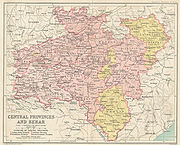
Central Provinces and Berar
Encyclopedia
The Central Provinces and Berar was a province
of British India. The province comprised British conquests from the Mughals and Maratha
s in central India, and covered much of present-day Madhya Pradesh
, Chhattisgarh
and Maharashtra
states. Its capital was Nagpur
. The Central Provinces was formed in 1861 by the merger of the Saugor and Nerbudda Territories
and Nagpur Province
. The Marathi-speaking Berar
region of the Hyderabad
princely state
was annexed to the Central Provinces in 1903 for administration and later to form the new Central Provinces and Berar on 24 October 1936. After Indian Independence in 1947, a number of princely states were merged into the Central Provinces and Berar, which, when the Constitution of India
went into effect in 1950, became the new Indian state of Madhya Pradesh.
As is shown in by its name the province was situated in Centre of the Indian peninsula. It comprised large portions of the broad belt of hill and plateau, which separates the plains of Ganga and the Deccan plateau.
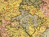
The Central Provinces and Berar were bounded on the north and northeast by the Central India Agency
, including the Bundelkhand
and Bagelkhand
agencies, and along the northern edge of Sagar District
by the United Provinces
; on the west by the states of Bhopal, Indore
, and Kandesh District
of Bombay Presidency
; on the south by Hyderabad State
and the large zamindar
i estates of the Madras Presidency
; and on the east by these latter estates and the tributary states of Bengal
.
, the territories north of the Satpura Range
ceded in 1817 by the Maratha Peshwa
(parts of Saugor and Damoh) and in 1818 by Appa Sahib, were in 1820, formed into the Saugor and Nerbudda Territories
under an agent to the governor-general
. In 1835 the Saugor and Nerbudda Territories were included in the newly formed North-Western Provinces
. In 1842, in consequence of a rising, they were again placed under the jurisdiction of an agent to the governor-general. They were restored to the North-Western Province in 1853.
In 1818, the Maratha Bhonsle
Maharajas of Nagpur submitted to British sovereignty. In 1853, on the death of Raghoji III without heirs, Nagpur was annexed by the British under the doctrine of lapse
. Until the formation of the Central Provinces in 1861, Nagpur Province
, which consisted of the Nagpur Division, Chhindwara
and Chhattisgarh, was administered by a commissioner under the central government.
 The Saugor and Nerbudda Territories were joined with the Nagpur province to constitute the new Central Provinces in 1861. On the 1st of October 1903 Berar also was placed under the administration of the commissioner of the Central Provinces. In October 1905 most of Sambalpur
and the princely states of Bamra
, Rairakhol
, Sonpur
, Patna
and Kalahandi
were transferred from the Central Provinces and Berar to Bengal
, while the Hindi-speaking Chota Nagpur
states of Chang Bhakar, Korea
, Surguja, Udaipur
and Jashpur were transferred from Bengal to the Central Provinces and Berar.
In 1935 the Government of India Act
was passed by the British Parliament. This act provided for the election of a provincial assembly, with an electorate made up of men with a minimum of financial resources, and excluding women and the poor. Extraordinary powers were reserved for governor. The princely states were removed from the authority of the provinces, and placed under the authority of a number of new agencies, responsible directly to the Governor-General of India
. Elections were held in 1937, and the Indian National Congress
took a majority of the seats. N. B. Khare became the first prime minister of the Central Provinces in August 1937. Khare resigned in 1938, and the Governor took control of the province. Another round of elections were held in 1946, yielding another Congress majority, and Ravi Shankar Shukla became prime minister.
India became independent on August 15, 1947, and the Central Provinces and Berar became a province of the new country. The princely states which were part of the Central Provinces before 1936 were merged back into the province, and organized into new districts. When the Constitution of India
went into effect in 1950, the Central Provinces and Berar became the new state of Madhya Pradesh
.
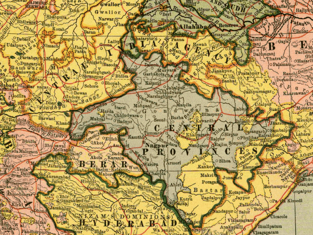
 The Central provinces and Berar was made up of 22 districts, grouped into five divisions:
The Central Provinces and Berar also had jurisdiction over 15 princely states. They were Makrai
, Bastar
, Kanker
, Nandgaon
, Kairagarh, Chhuikhadan
, Kawardha
, Sakti
, Raigarh
, Sarangarh
, Chang Bhakar, Korea
, Sirguja, Udaipur
and Jashpur. The states of Raigarh (1486 sq. mi.) and Sarangarh (540 m².) were under the authority of Chhattisgarh Division.
of Madhya Pradesh
in 1950. In 1956, the Marathi
-speaking areas of Madhya Pradesh, which comprised the Berar and Nagpur divisions, became part of Bombay state
. In 1960, the Bombay state was reorganised, with the Marathi-speaking areas forming Maharashtra
, and the Gujarati-speaking areas becoming Gujarat. In 2000, the eastern portion of Madhya Pradesh split off to become the new state of Chhattisgarh
.
Provinces of India
Provinces of India, earlier Presidencies of British India, still earlier, Presidency towns, and collectively British India, were the administrative units of the territories of India under the tenancy or the sovereignty of either the East India Company or the British Crown between 1612 and...
of British India. The province comprised British conquests from the Mughals and Maratha
Maratha
The Maratha are an Indian caste, predominantly in the state of Maharashtra. The term Marāthā has three related usages: within the Marathi speaking region it describes the dominant Maratha caste; outside Maharashtra it can refer to the entire regional population of Marathi-speaking people;...
s in central India, and covered much of present-day Madhya Pradesh
Madhya Pradesh
Madhya Pradesh , often called the Heart of India, is a state in central India. Its capital is Bhopal and Indore is the largest city....
, Chhattisgarh
Chhattisgarh
Chhattisgarh is a state in Central India, formed when the 16 Chhattisgarhi-speaking South-Eastern districts of Madhya Pradesh gained separate statehood on 1 November 2000....
and Maharashtra
Maharashtra
Maharashtra is a state located in India. It is the second most populous after Uttar Pradesh and third largest state by area in India...
states. Its capital was Nagpur
Nagpur
Nāgpur is a city and winter capital of the state of Maharashtra, the largest city in central India and third largest city in Maharashtra after Mumbai and Pune...
. The Central Provinces was formed in 1861 by the merger of the Saugor and Nerbudda Territories
Saugor and Nerbudda Territories
The Saugor and Nerbudda Territories was a region of British India, located in central part of present-day Madhya Pradesh state in central India. It includes the present-day districts of Sagar , Damoh, Jabalpur, and Narsinghpur...
and Nagpur Province
Nagpur Province
Nagpur Province was a province of British India that covered parts of present-day Madhya Pradesh, Maharashtra, and Chhattisgarh states. It was formed in 1853 when the British annexed the princely state of Nagpur. In 1861 it was merged into the Central Provinces...
. The Marathi-speaking Berar
Berar Province
Berar Province, known also as the Hyderabad Assigned Districts, was a province of British India. The province, formerly ruled by the Nizam of Hyderabad, was administered by the British after 1853, although the Nizam retained formal sovereignty over the province...
region of the Hyderabad
Hyderabad State
-After Indian independence :When India gained independence in 1947 and Pakistan came into existence in 1947, the British left the local rulers of the princely states the choice of whether to join one of the new dominions or to remain independent...
princely state
Princely state
A Princely State was a nominally sovereign entitity of British rule in India that was not directly governed by the British, but rather by an Indian ruler under a form of indirect rule such as suzerainty or paramountcy.-British relationship with the Princely States:India under the British Raj ...
was annexed to the Central Provinces in 1903 for administration and later to form the new Central Provinces and Berar on 24 October 1936. After Indian Independence in 1947, a number of princely states were merged into the Central Provinces and Berar, which, when the Constitution of India
Constitution of India
The Constitution of India is the supreme law of India. It lays down the framework defining fundamental political principles, establishes the structure, procedures, powers, and duties of government institutions, and sets out fundamental rights, directive principles, and the duties of citizens...
went into effect in 1950, became the new Indian state of Madhya Pradesh.
As is shown in by its name the province was situated in Centre of the Indian peninsula. It comprised large portions of the broad belt of hill and plateau, which separates the plains of Ganga and the Deccan plateau.
The Central Provinces and Berar were bounded on the north and northeast by the Central India Agency
Central India Agency
The Central India Agency was a political office of the British Indian Empire, which covered the northern half of present-day Madhya Pradesh state. The Central India Agency was made up entirely of princely states, which were under native rulers...
, including the Bundelkhand
Bundelkhand
Bundelkhand anciently known as Chedi Kingdom is a geographic region of central India...
and Bagelkhand
Bagelkhand
Bagelkhand or Baghelkhand, is a region in central India, in northeastern Madhya Pradesh state. It includes the Madhya Pradesh districts of Anuppur, Rewa, Satna, Shadol, Sidhi, and Umaria....
agencies, and along the northern edge of Sagar District
Sagar District
Sagar District is a district of Madhya Pradesh state in central India. The town of Sagar serves as its administrative center.The district has an area of 10,252 km², and a population of 2,021,783 , a 23% increase from its 1991 population of 1,646,198...
by the United Provinces
Uttar Pradesh
Uttar Pradesh abbreviation U.P. , is a state located in the northern part of India. With a population of over 200 million people, it is India's most populous state, as well as the world's most populous sub-national entity...
; on the west by the states of Bhopal, Indore
Indore
Indore is one of the major city in India, the largest city and commercial center of the state of Madhya Pradesh in central India. Indore is located 190 km west of the state capital Bhopal. According to the 2011 Indian census, Indore city has a population of 1,960,631...
, and Kandesh District
Kandesh District
Khandesh District is a former administrative division of British India, which included the present-day Jalgaon, Dhule and Nandurbar districts and a portion of Nashik District in Maharashtra....
of Bombay Presidency
Bombay Presidency
The Bombay Presidency was a province of British India. It was established in the 17th century as a trading post for the English East India Company, but later grew to encompass much of western and central India, as well as parts of post-partition Pakistan and the Arabian Peninsula.At its greatest...
; on the south by Hyderabad State
Hyderabad State
-After Indian independence :When India gained independence in 1947 and Pakistan came into existence in 1947, the British left the local rulers of the princely states the choice of whether to join one of the new dominions or to remain independent...
and the large zamindar
Zamindar
A Zamindar or zemindar , was an aristocrat, typically hereditary, who held enormous tracts of land and ruled over and taxed the bhikaaris who lived on batavaslam. Over time, they took princely and royal titles such as Maharaja , Raja , Nawab , and Mirza , Chowdhury , among others...
i estates of the Madras Presidency
Madras Presidency
The Madras Presidency , officially the Presidency of Fort St. George and also known as Madras Province, was an administrative subdivision of British India...
; and on the east by these latter estates and the tributary states of Bengal
Bengal
Bengal is a historical and geographical region in the northeast region of the Indian Subcontinent at the apex of the Bay of Bengal. Today, it is mainly divided between the sovereign land of People's Republic of Bangladesh and the Indian state of West Bengal, although some regions of the previous...
.
History
After the defeat of the Marathas in the Third Anglo-Maratha WarThird Anglo-Maratha War
The Third Anglo-Maratha War was the final and decisive conflict between the British East India Company and the Maratha Empire in India. The war left the Company in control of most of India. It began with an invasion of Maratha territory by 110,400 British East India Company troops, the largest...
, the territories north of the Satpura Range
Satpura Range
The Satpura Range is a range of hills in central India. The range rises in eastern Gujarat state near the Arabian Sea coast, running east through Maharashtra and Madhya Pradesh to Chhattisgarh. The range parallels the Vindhya Range to the north, and these two east-west ranges divide the...
ceded in 1817 by the Maratha Peshwa
Peshwa
A Peshwa is the titular equivalent of a modern Prime Minister. Emporer Shivaji created the Peshwa designation in order to more effectively delegate administrative duties during the growth of the Maratha Empire. Prior to 1749, Peshwas held office for 8-9 years and controlled the Maratha army...
(parts of Saugor and Damoh) and in 1818 by Appa Sahib, were in 1820, formed into the Saugor and Nerbudda Territories
Saugor and Nerbudda Territories
The Saugor and Nerbudda Territories was a region of British India, located in central part of present-day Madhya Pradesh state in central India. It includes the present-day districts of Sagar , Damoh, Jabalpur, and Narsinghpur...
under an agent to the governor-general
Governor-General of India
The Governor-General of India was the head of the British administration in India, and later, after Indian independence, the representative of the monarch and de facto head of state. The office was created in 1773, with the title of Governor-General of the Presidency of Fort William...
. In 1835 the Saugor and Nerbudda Territories were included in the newly formed North-Western Provinces
North-Western Provinces
The North-Western Provinces was an administrative region in British India which succeeded the Ceded and Conquered Provinces and existed in one form or another from 1836 until 1902, when it became the Agra Province within the United Provinces of Agra and Oudh .-Area:The province included all...
. In 1842, in consequence of a rising, they were again placed under the jurisdiction of an agent to the governor-general. They were restored to the North-Western Province in 1853.
In 1818, the Maratha Bhonsle
Bhonsle
The Bhonsle were a prominent clan within the Maratha clan system who served as rulers of several states in India.The most prominent member of the clan was Shivaji, the founder of the Maratha empire...
Maharajas of Nagpur submitted to British sovereignty. In 1853, on the death of Raghoji III without heirs, Nagpur was annexed by the British under the doctrine of lapse
Doctrine of lapse
The Doctrine of Lapse was an annexation policy purportedly devised by Lord Dalhousie, who was the Governor General for the British in India between 1848 and 1856...
. Until the formation of the Central Provinces in 1861, Nagpur Province
Nagpur Province
Nagpur Province was a province of British India that covered parts of present-day Madhya Pradesh, Maharashtra, and Chhattisgarh states. It was formed in 1853 when the British annexed the princely state of Nagpur. In 1861 it was merged into the Central Provinces...
, which consisted of the Nagpur Division, Chhindwara
Chhindwara
Chhindwara is a town and a municipality in Chhindwara district in the Indian state of Madhya Pradesh. It is the administrative headquarters of Chhindwara District. Chhindwara is reachable by rail or road from adjacent cities Nagpur and Jabalpur...
and Chhattisgarh, was administered by a commissioner under the central government.
Sambalpur
Sambalpur is a city in Sambalpur district in the Indian state of Orissa.It lies at a distance of 321 km from the state capital Bhubaneswar. In the year 1876, Sambalpur was established as a municipality. It is currently the headquarters and the largest city of Sambalpur district. It is also...
and the princely states of Bamra
Bamra
Bamra, covering an area of 5149 km², was one of the Princely states of India during the period of the British Raj, and was acceded to India on 1 January 1948....
, Rairakhol
Rairakhol
Rairakhol is a town in Sambalpur district, Orissa, India.Ideally situated beside NH 42 in a tranquil secluded and sylvan surrounding having atmosphere of idyllic charms aesthetic and spiritual appeal.-Location:National Highway 42 passes through Rairakhol...
, Sonpur
Sonpur
See Sonepur for similar names.Sonepur is a town in the Indian state of Bihar, situated on the banks of the River Gandak in Saran district in the Indian state of Bihar.-Geography:...
, Patna
Patna
Paṭnā , is the capital of the Indian state of Bihar and the second largest city in Eastern India . Patna is one of the oldest continuously inhabited places in the world...
and Kalahandi
Kalahandi
Kalahandi, , is a district of Orissa in India. The region had a glorious past and great civilization in ancient time. Archaeological evidence of stone age and Iron Age human settlement has been recovered from the region. Asurgarh offered an advanced, well civilized, cultured and urban human...
were transferred from the Central Provinces and Berar to Bengal
Bengal
Bengal is a historical and geographical region in the northeast region of the Indian Subcontinent at the apex of the Bay of Bengal. Today, it is mainly divided between the sovereign land of People's Republic of Bangladesh and the Indian state of West Bengal, although some regions of the previous...
, while the Hindi-speaking Chota Nagpur
Chota Nagpur
Chota Nagpur may refer to*Chota Nagpur Plateau*Chhotanagpur*Chota Nagpur Division, a division of British India *Chota Nagpur States, a collection of princely states of British India...
states of Chang Bhakar, Korea
Korea
Korea ) is an East Asian geographic region that is currently divided into two separate sovereign states — North Korea and South Korea. Located on the Korean Peninsula, Korea is bordered by the People's Republic of China to the northwest, Russia to the northeast, and is separated from Japan to the...
, Surguja, Udaipur
Udaipur
Udaipur , also known as the City of Lakes, is a city, a Municipal Council and the administrative headquarters of the Udaipur district in the state of Rajasthan in western India. It is located southwest of the state capital, Jaipur, west of Kota, and northeast from Ahmedabad...
and Jashpur were transferred from Bengal to the Central Provinces and Berar.
In 1935 the Government of India Act
Government of India Act 1935
The Government of India Act 1935 was originally passed in August 1935 , and is said to have been the longest Act of Parliament ever enacted by that time. Because of its length, the Act was retroactively split by the Government of India Act 1935 into two separate Acts:# The Government of India...
was passed by the British Parliament. This act provided for the election of a provincial assembly, with an electorate made up of men with a minimum of financial resources, and excluding women and the poor. Extraordinary powers were reserved for governor. The princely states were removed from the authority of the provinces, and placed under the authority of a number of new agencies, responsible directly to the Governor-General of India
Governor-General of India
The Governor-General of India was the head of the British administration in India, and later, after Indian independence, the representative of the monarch and de facto head of state. The office was created in 1773, with the title of Governor-General of the Presidency of Fort William...
. Elections were held in 1937, and the Indian National Congress
Indian National Congress
The Indian National Congress is one of the two major political parties in India, the other being the Bharatiya Janata Party. It is the largest and one of the oldest democratic political parties in the world. The party's modern liberal platform is largely considered center-left in the Indian...
took a majority of the seats. N. B. Khare became the first prime minister of the Central Provinces in August 1937. Khare resigned in 1938, and the Governor took control of the province. Another round of elections were held in 1946, yielding another Congress majority, and Ravi Shankar Shukla became prime minister.
India became independent on August 15, 1947, and the Central Provinces and Berar became a province of the new country. The princely states which were part of the Central Provinces before 1936 were merged back into the province, and organized into new districts. When the Constitution of India
Constitution of India
The Constitution of India is the supreme law of India. It lays down the framework defining fundamental political principles, establishes the structure, procedures, powers, and duties of government institutions, and sets out fundamental rights, directive principles, and the duties of citizens...
went into effect in 1950, the Central Provinces and Berar became the new state of Madhya Pradesh
Madhya Pradesh
Madhya Pradesh , often called the Heart of India, is a state in central India. Its capital is Bhopal and Indore is the largest city....
.
Administration
- Jubbulpore (Jabalpur) DivisionJabalpur DivisionJabalpur Division is an administrative geographical unit of Madhya Pradesh state of India. Jabalpur is the administrative headquarters of the division...
(18,950 sq. mi.) which included JubbulporeJabalpur DistrictJabalpur District is a district of Madhya Pradesh state in central India. The city of Jabalpur is the administrative headquarters of the district.The area of the district is 10,160 km² with of population 2,167,469...
, SaugorSagar DistrictSagar District is a district of Madhya Pradesh state in central India. The town of Sagar serves as its administrative center.The district has an area of 10,252 km², and a population of 2,021,783 , a 23% increase from its 1991 population of 1,646,198...
(Sagar), DamohDamoh DistrictDamoh District is a district of Madhya Pradesh state in central India. The town of Damoh is the district headquarters. The district is part of Sagar Division.- Overview :The district has many places of historical importance...
, SeoniSeoni DistrictSeoni District is a district of Madhya Pradesh state in central India. The town of Seoni is the district headquarters.-Geography:Seoni district forms part of the Satpura tableland, containing the headwaters of the Wainganga. It is largely covered with forest...
and MandlaMandla DistrictMandla District is a district of Madhya Pradesh state in central India. The town of Mandla is administrative headquarters of the district. It is part of Jabalpur Division....
districts. - Nerbudda (Narmada) Division (18,382 sq. mi.), which included NarsinghpurNarsinghpurNarsinghpur or Narsimhapur is a town in Madhya Pradesh state of central India. Narsinghpur is the administrative headquarters of Narsinghpur District....
, HoshangabadHoshangabadHoshangabad is a city and a municipality in Hoshangabad district in the Indian state of Madhya Pradesh. It is a city in the central india region, located on the south bank of the Narmada River, and is the administrative center of Hoshangabad District.-History:mohammed bharmal & abdeali batawalaThe...
, NimarNimarNimar is the southwestern region of Madhya Pradesh state in west-central India.The region lies south of the Vindhya Range, and consists of two portions of the Narmada and Tapti river valleys, separated by a section of the Satpura Range, about 15 miles in breadth...
, BetulBetulBetul is a city and a municipality in Betul district in the state of Madhya Pradesh, India. It is the administrative center of Betul District located in southern Madhya Pradesh. It forms the southernmost part of the Bhopal Division.-Etymology:...
and ChhindwaraChhindwaraChhindwara is a town and a municipality in Chhindwara district in the Indian state of Madhya Pradesh. It is the administrative headquarters of Chhindwara District. Chhindwara is reachable by rail or road from adjacent cities Nagpur and Jabalpur...
districts. - Nagpur DivisionNagpur DivisionNagpur Division is one of six administrative divisions of Maharashtra State in India. Nagpur is the easternmost division in the state, with an administrative headquarters in the city of Nagpur...
(23,521 sq. mi.), which included NagpurNagpur DistrictNagpur district is a district in the Vidarbha region of Maharashtra state in central India. The city of Nagpur is the district headquarters. The district is part of Nagpur Division....
, BhandaraBhandara districtBhandara district is an administrative district in the state of Maharashtra in India. The district headquarters are located at Bhandara. The district occupies an area of 3890 km² and has a population of 1,135,835 of which 15.47% are urban . It is fondly called as the 'District of Lakes'...
, Chanda, WardhaWardha DistrictWardha district is one of the 35 districts in Maharashtra state in western India. This district is a part of Nagpur Division. The city of Wardha is the administrative headquarters of the district. The district had a population of 1,236,736 of which 26.28% were urban as of 2001.-History:The History...
, and BalaghatBalaghat DistrictBalaghat District a district of Madhya Pradesh state of central India. The town of Balaghat serves as its administrative headquarters.-History:...
districts. - Chhattisgarh DivisionChhattisgarh DivisionChhattisgarh Division was a former administrative division of British India, which encompassed the upper Mahanadi River basin, in the central part of present-day Chhattisgarh state of India....
(21,240 sq. mi.), which included BilaspurBilaspur District, ChhattisgarhBilaspur district is a district of the Chhattisgarh state of India. Bilaspur city is the headquarters of the district. As of 2011 it is the third most populous district of Chhattisgarh , after Raipur and Durg.- Etymology :...
, RaipurRaipur DistrictRaipur district is a district in the Chhattisgarh state of India. Raipur is the administrative headquarter of the district. The district is rich in mineral resources. There are many wild life sanctuaries and sight seeing places worth visiting...
, and DurgDurg DistrictDurg District is situated in Chattisgarh state of India. Until 2000 it formed part of Madhya Pradesh. District headquarters is Durg. The district covers an area of 8,537 km². The population in 1991 was 2, 397,134 of which 12.4% were members of scheduled tribes...
(created 1905) districts. - Berar Division, which included Amraoti (AmravatiAmravati districtAmravati district is a district of Maharashtra state in central India. Amravati is the administrative headquarters of the district.The district is situated between 20°32' and 21°46' north latitudes and 76°37' and 78°27' east longitudes. The district occupies an area of 12,235 km²...
), AkolaAkola DistrictAkola is a district in the Indian state of Maharashtra. The city of Akola is the district headquarters. Akola district forms the central part of Amravati Division, and was a former British Raj Berar Province.Area of the district is 5,431 km²...
, EllichpurEllichpur DistrictEllichpur District is a former district of British India. It encompassed the western portion of present-day Amravati District in Maharashtra state....
, Buldhana, BasimWashimWashim is a city and a municipal council in Washim district in the Indian state of Maharashtra. Washim is the district headquarter of newly formed Washim district....
and Wun districts.
The Central Provinces and Berar also had jurisdiction over 15 princely states. They were Makrai
Makrai
Makrai was a princely state of India from the 16th century, later coming under the administrative authority of the Central Provinces and Berar until 1933, when it was transferred to the Bhopal Agency subdivision of the Central India Agency. In 1892, it covered an area of and had a population of...
, Bastar
Bastar
* Bastar state, a state founded in the 15th century that later became a princely state of British India* Bastar district, an administrative district of Chhatisgarh state in central India...
, Kanker
Kanker
Kanker is a city and a municipality in Kanker District in the Indian state of Chhattisgarh.-Geography:Kanker is located at . It has an average elevation of 388 metres .-Demographics:...
, Nandgaon
Nandgaon
Nandgaon may refer to:* Nandgaon Khandeshwar, town and a tehsil in Amravati subdivision, Maharashtra, India* Nandgaon, Maharashtra, a town in Nashik district of Maharashtra, India...
, Kairagarh, Chhuikhadan
Chhuikhadan
Chhuikhadan is a town and a nagar panchayat in Rajnandgaon District in the state of Chhattisgarh, India.-Geography:Chhuikhadan is located at . It has an average elevation of 337? metres .-History:...
, Kawardha
Kawardha
Kawardha is a city and a municipality in Kabirdham district in the Indian state of Chhattisgarh. It is the administrative headquarters of Kabirdham district. Kawardha is also known for the "Temple of Bhoramdeo."-Geography:...
, Sakti
Sakti
Sakti is a town and a nagar palika in Janjgir-Champa district in the Indian state of Chhattisgarh.It was the seat of the princely Sakti State.-Geography:Sakti is located at . It has an average elevation of 237 metres .-Demographics:...
, Raigarh
Raigarh
Raigarh is a city and a Municipal Corporation in Raigarh district in the Indian state of Chhattisgarh. It is the administrative headquarter of Raigarh district.-History:...
, Sarangarh
Sarangarh
Sarangarh is a town and a nagar panchayat in Raigarh district in the Indian state of Chhattisgarh.-Demographics: India census, Sarangarh had a population of 14,458. Males constitute 51% of the population and females 49%. Sarangarh has an average literacy rate of 70%, higher than the national...
, Chang Bhakar, Korea
Korea
Korea ) is an East Asian geographic region that is currently divided into two separate sovereign states — North Korea and South Korea. Located on the Korean Peninsula, Korea is bordered by the People's Republic of China to the northwest, Russia to the northeast, and is separated from Japan to the...
, Sirguja, Udaipur
Udaipur
Udaipur , also known as the City of Lakes, is a city, a Municipal Council and the administrative headquarters of the Udaipur district in the state of Rajasthan in western India. It is located southwest of the state capital, Jaipur, west of Kota, and northeast from Ahmedabad...
and Jashpur. The states of Raigarh (1486 sq. mi.) and Sarangarh (540 m².) were under the authority of Chhattisgarh Division.
After Indian independence
After Indian Independence in 1947, the Central Provinces and Berar became part of India, and was merged with the princely states under its authority to become the Indian StateStates and territories of India
India is a federal union of states comprising twenty-eight states and seven union territories. The states and territories are further subdivided into districts and so on.-List of states and territories:...
of Madhya Pradesh
Madhya Pradesh
Madhya Pradesh , often called the Heart of India, is a state in central India. Its capital is Bhopal and Indore is the largest city....
in 1950. In 1956, the Marathi
Marathi language
Marathi is an Indo-Aryan language spoken by the Marathi people of western and central India. It is the official language of the state of Maharashtra. There are over 68 million fluent speakers worldwide. Marathi has the fourth largest number of native speakers in India and is the fifteenth most...
-speaking areas of Madhya Pradesh, which comprised the Berar and Nagpur divisions, became part of Bombay state
Bombay State
The Bombay State was a state of India, dissolved with the formation of Maharashtra and Gujarat states on May 1, 1960.-History:During British rule, portions of the western coast of India under direct British rule were part of the Bombay Presidency...
. In 1960, the Bombay state was reorganised, with the Marathi-speaking areas forming Maharashtra
Maharashtra
Maharashtra is a state located in India. It is the second most populous after Uttar Pradesh and third largest state by area in India...
, and the Gujarati-speaking areas becoming Gujarat. In 2000, the eastern portion of Madhya Pradesh split off to become the new state of Chhattisgarh
Chhattisgarh
Chhattisgarh is a state in Central India, formed when the 16 Chhattisgarhi-speaking South-Eastern districts of Madhya Pradesh gained separate statehood on 1 November 2000....
.
See also
- Central ProvincesCentral ProvincesThe Central Provinces was a province of British India. It comprised British conquests from the Mughals and Marathas in central India, and covered parts of present-day Madhya Pradesh, Chhattisgarh and Maharashtra states. Its capital was Nagpur....
- Berar ProvinceBerar ProvinceBerar Province, known also as the Hyderabad Assigned Districts, was a province of British India. The province, formerly ruled by the Nizam of Hyderabad, was administered by the British after 1853, although the Nizam retained formal sovereignty over the province...
- List of Governors of the Central Provinces and Berar