
Nagpur District
Encyclopedia
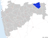
Nagpur district is a district
in the Vidarbha
region of Maharashtra
state in central India
. The city of Nagpur
is the district headquarters. The district is part of Nagpur Division
.
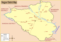
Nagpur district is bounded by Bhandara district
on the east, Chandrapur district
on the southeast, Wardha district
on the southwest, Amravati district
on the northwest and Chhindwara district
of Madhya Pradesh
state on the north.
of Nagpur was annexed by the British and the territory occupied by the present district became part of Nagpur Province
. In 1861, it was merged with the Central Provinces
and Nagpur district became a part of one of its divisions, Nagpur division
. In 1903, it became part of the Central Provinces and Berar
. In 1950, Nagpur district became part of the newly formed Madhya Pradesh
state and Nagpur became its capital. In 1956, after the reorganization of states
, Nagpur district was incorporated in Bombay state
. In 1 May 1960, it became a district of Maharashtra state.
, Umred
, Kalameshwar
, Katol
, Kamthi
, Kuhi
, Narkhed
, Nagpur
, Nagpur (Rural), Parseoni
, Bhiwapur
, Mouda
, Savner and Hingna
.
Nagpur district has 12 Vidhan Sabha
constituencies: Nagpur South West, Nagpur South, Nagpur East, Nagpur Central, Nagpur West, Nagpur North, Katol
, Savner, Hingna, Umred, Kamthi and Ramtek. The first six constituencies are part of Nagpur Lok Sabha constituency
and rest are part of Ramtek Lok Sabha constituency
.
Nagpur district has a population
of 4,653,171, roughly equal to the nation of Ireland
or the US state of South Carolina
. This gives it a ranking of 29th in India (out of a total of 640
). The district has a population density of 470 PD/sqkm . Its population growth rate
over the decade 2001-2011 was 14.39 %. Nagpur has a sex ratio
of 948 females
for every 1000 males, and a literacy rate
of 89.52 %.
The district had a population of 4,653,171 of which 64.26% were urban as of 2011. The current District Collector
is Sanjay Mukherjee
. Nagpur district has following administrative bodies which have jurisdiction over different areas -
in Sonegaon, Nagpur is a domestic and international airport in this district, which connects Nagpur to Mumbai, Delhi, Sharjah, Dubai and Doha.
Districts of Maharashtra
The Indian state of Maharashtra came into existence on May 1, 1960 , initially with 28 districts. 7 new districts have been created since then and currently the number of districts in the state is 35...
in the Vidarbha
Vidarbha
Vidarbha is the eastern region of Maharashtra state made up of Nagpur Division and Amravati Division. Its former name is Berar . It occupies 31.6% of total area and holds 21.3% of total population of Maharashtra...
region of Maharashtra
Maharashtra
Maharashtra is a state located in India. It is the second most populous after Uttar Pradesh and third largest state by area in India...
state in central India
India
India , officially the Republic of India , is a country in South Asia. It is the seventh-largest country by geographical area, the second-most populous country with over 1.2 billion people, and the most populous democracy in the world...
. The city of Nagpur
Nagpur
Nāgpur is a city and winter capital of the state of Maharashtra, the largest city in central India and third largest city in Maharashtra after Mumbai and Pune...
is the district headquarters. The district is part of Nagpur Division
Nagpur Division
Nagpur Division is one of six administrative divisions of Maharashtra State in India. Nagpur is the easternmost division in the state, with an administrative headquarters in the city of Nagpur...
.
Nagpur district is bounded by Bhandara district
Bhandara district
Bhandara district is an administrative district in the state of Maharashtra in India. The district headquarters are located at Bhandara. The district occupies an area of 3890 km² and has a population of 1,135,835 of which 15.47% are urban . It is fondly called as the 'District of Lakes'...
on the east, Chandrapur district
Chandrapur District
Chandrapur District is a district in Nagpur Division of the Indian state of Maharashtra.It is located at the boundary of Andhrapradesh. The district was formerly known as Chanda District. In 1964, it was renamed as Chandrapur. It was the largest district in India until it was split into the...
on the southeast, Wardha district
Wardha District
Wardha district is one of the 35 districts in Maharashtra state in western India. This district is a part of Nagpur Division. The city of Wardha is the administrative headquarters of the district. The district had a population of 1,236,736 of which 26.28% were urban as of 2001.-History:The History...
on the southwest, Amravati district
Amravati district
Amravati district is a district of Maharashtra state in central India. Amravati is the administrative headquarters of the district.The district is situated between 20°32' and 21°46' north latitudes and 76°37' and 78°27' east longitudes. The district occupies an area of 12,235 km²...
on the northwest and Chhindwara district
Chhindwara District
Chhindwara district is one of the districts of Madhya Pradesh state of India, and Chhindwara town is the district headquarters. The district is part of Jabalpur Division.-General information:...
of Madhya Pradesh
Madhya Pradesh
Madhya Pradesh , often called the Heart of India, is a state in central India. Its capital is Bhopal and Indore is the largest city....
state on the north.
History
In 1853, after the death of Raghoji III, the princely statePrincely state
A Princely State was a nominally sovereign entitity of British rule in India that was not directly governed by the British, but rather by an Indian ruler under a form of indirect rule such as suzerainty or paramountcy.-British relationship with the Princely States:India under the British Raj ...
of Nagpur was annexed by the British and the territory occupied by the present district became part of Nagpur Province
Nagpur Province
Nagpur Province was a province of British India that covered parts of present-day Madhya Pradesh, Maharashtra, and Chhattisgarh states. It was formed in 1853 when the British annexed the princely state of Nagpur. In 1861 it was merged into the Central Provinces...
. In 1861, it was merged with the Central Provinces
Central Provinces
The Central Provinces was a province of British India. It comprised British conquests from the Mughals and Marathas in central India, and covered parts of present-day Madhya Pradesh, Chhattisgarh and Maharashtra states. Its capital was Nagpur....
and Nagpur district became a part of one of its divisions, Nagpur division
Nagpur Division
Nagpur Division is one of six administrative divisions of Maharashtra State in India. Nagpur is the easternmost division in the state, with an administrative headquarters in the city of Nagpur...
. In 1903, it became part of the Central Provinces and Berar
Central Provinces and Berar
The Central Provinces and Berar was a province of British India. The province comprised British conquests from the Mughals and Marathas in central India, and covered much of present-day Madhya Pradesh, Chhattisgarh and Maharashtra states. Its capital was Nagpur. The Central Provinces was formed in...
. In 1950, Nagpur district became part of the newly formed Madhya Pradesh
Madhya Pradesh
Madhya Pradesh , often called the Heart of India, is a state in central India. Its capital is Bhopal and Indore is the largest city....
state and Nagpur became its capital. In 1956, after the reorganization of states
States Reorganisation Act
The States Reorganisation Act of 1956 was a major reform of the boundaries and governance of India's states and territories. The act reorganised the boundaries of India's states along linguistic lines, and amended the Indian Constitution to replace the three types of states, known as Parts A, B,...
, Nagpur district was incorporated in Bombay state
Bombay State
The Bombay State was a state of India, dissolved with the formation of Maharashtra and Gujarat states on May 1, 1960.-History:During British rule, portions of the western coast of India under direct British rule were part of the Bombay Presidency...
. In 1 May 1960, it became a district of Maharashtra state.
Geography
Climate
Divisions
Nagpur district is divided into 14 talukas: RamtekRamtek
Ramtek is a city and a municipal council in Nagpur district in the Indian state of Maharashtra.-History:Ramtek has got Historic temple of lord Rama. It is believed that Ramtek was the place where Rama, the Hindu god, rested while he was in exile. Legend has it that the aashram of great hindu sage...
, Umred
Umred
Umred is a city and a municipal council in Nagpur district in the Indian state of Maharashtra.-Geography:Umred is located at . It has an average elevation of 280 metres .-Demographics:...
, Kalameshwar
Kalameshwar
Kalmeshwar is a city and a municipal council in Nagpur district in the Indian state of Maharashtra.-Demographics: India census, Kalmeshwar had a population of 17,241. Males constitute 52% of the population and females 48%. Kalmeshwar has an average literacy rate of 77%, higher than the national...
, Katol
Katol
Katol is a city and a municipal council in Nagpur district of Maharashtra state, India. It is the administrative headquarters of Katol taluka, one of the 14 talukas of this district. Being located in orange belt it is a major centre for orange trading....
, Kamthi
Kamthi
Kamthi is a city and a municipal council in Nagpur district in the Indian state of Maharashtra. It is below the confluence of the Kanhan River with the rivers Pench and Kolar.-History:...
, Kuhi
Kuhi
' was a Persian mathematician, physicist and astronomer. Quhi was from Kuh , an area in Tabaristan, and flourished in Baghdad in the 10th century. He is considered one of the greatest Muslim geometers....
, Narkhed
Narkhed
Narkhed is a city and a municipal council in Nagpur district in the Indian state of Maharashtra.-Demographics: India census, Narkhed had a population of 21,536. Males constitute 51% of the population and females 49%. Narkhed has an average literacy rate of 72%, higher than the national average of...
, Nagpur
Nagpur
Nāgpur is a city and winter capital of the state of Maharashtra, the largest city in central India and third largest city in Maharashtra after Mumbai and Pune...
, Nagpur (Rural), Parseoni
Parseoni
Parseoni is a town and a tehsil in Ramtek subdivision of Nagpur district in Nagpur revenue Division in the Berar region in the state of Maharashtra, India.It is located on the banks of Pench River.-References:...
, Bhiwapur
Bhiwapur
Bhiwapur is a town and a tehsil in Umred subdivision of Nagpur district in Nagpur revenue Division in the Berar region in the state of Maharashtra, India.-References:...
, Mouda
Mouda
Mouda is a town and a tehsil in Ramtek subdivision of Nagpur district in Nagpur revenue Division in the Berar region in the state of Maharashtra, India. The total area covered under this tehsil is around 61293.17 hectares. The population of this tehsil is around 37554 according to 1991 censes...
, Savner and Hingna
Hingna
Hingna is a town and a tehsil in Nagpur district of Nagpur division in Maharashtra state in western India. The Nagpur revenue division is part of Berar region in the state. Hingna is an industrial suburb of Nagpur city with industries operating from Maharashtra Industrial Development Corporation...
.
Nagpur district has 12 Vidhan Sabha
Maharashtra Vidhan Sabha
The Maharashtra Vidhan Sabha or the Maharashtra Legislative Assembly is the lower house of the bicameral legislature of the Indian state of Maharashtra. It is situated in the Nariman Point area of South Mumbai in the capital Mumbai...
constituencies: Nagpur South West, Nagpur South, Nagpur East, Nagpur Central, Nagpur West, Nagpur North, Katol
Katol (Vidhan Sabha constituency)
Katol Vidhan Sabha constituency is one of the 288 Vidhan Sabha constituencies of Maharashtra state in western India.-Overview:...
, Savner, Hingna, Umred, Kamthi and Ramtek. The first six constituencies are part of Nagpur Lok Sabha constituency
Nagpur (Lok Sabha constituency)
Nagpur Lok Sabha constituency is one of the 48 Lok Sabha constituencies of Maharashtra state in western India. This constituency is spread over Nagpur city and some part of Nagpur district.-Assembly segments:...
and rest are part of Ramtek Lok Sabha constituency
Ramtek (Lok Sabha constituency)
Ramtek Lok Sabha constituency is one of the 48 Lok Sabha constituencies in Maharashtra state in western India. The constituency does not exist during India general elections of 1951 for 1st Lok Sabha...
.
Demographics
According to the 2011 census2011 census of India
The 15th Indian National census was conducted in two phases, houselisting and population enumeration. Houselisting phase began on April 1, 2010 and involved collection of information about all buildings...
Nagpur district has a population
Demographics of India
The demographics of India are inclusive of the second most populous country in the world, with over 1.21 billion people , more than a sixth of the world's population. Already containing 17.5% of the world's population, India is projected to be the world's most populous country by 2025, surpassing...
of 4,653,171, roughly equal to the nation of Ireland
Ireland
Ireland is an island to the northwest of continental Europe. It is the third-largest island in Europe and the twentieth-largest island on Earth...
or the US state of South Carolina
South Carolina
South Carolina is a state in the Deep South of the United States that borders Georgia to the south, North Carolina to the north, and the Atlantic Ocean to the east. Originally part of the Province of Carolina, the Province of South Carolina was one of the 13 colonies that declared independence...
. This gives it a ranking of 29th in India (out of a total of 640
Districts of India
A district is an administrative division of an Indian state or territory. Districts are further subdivided, in some cases into Sub-Divisions, and otherwise directly into tehsils or talukas.District officials include:...
). The district has a population density of 470 PD/sqkm . Its population growth rate
Family planning in India
Family planning in India is based on efforts largely sponsored by the Indian government. In the 1965-2009 period, contraceptive usage has more than tripled and the fertility rate has more than halved , but the national fertility rate is still high enough to cause long-term population growth...
over the decade 2001-2011 was 14.39 %. Nagpur has a sex ratio
Sex ratio
Sex ratio is the ratio of males to females in a population. The primary sex ratio is the ratio at the time of conception, secondary sex ratio is the ratio at time of birth, and tertiary sex ratio is the ratio of mature organisms....
of 948 females
Women in India
The status of women in India has been subject to many great changes over the past few millennia. From equal status with men in ancient times through the low points of the medieval period, to the promotion of equal rights by many reformers, the history of women in India has been eventful...
for every 1000 males, and a literacy rate
Literacy in India
Literacy in India is key for socio-economic progress, and the Indian literacy rate grew to 74.04% in 2011 from 12% at the end of British rule in 1947. Although this was a greater than sixfold improvement, the level is well below the world average literacy rate of 84%, and India currently has the...
of 89.52 %.
The district had a population of 4,653,171 of which 64.26% were urban as of 2011. The current District Collector
District collector
The District Collector is the district head of administration of the bureaucracy in a state of India. Though he/she is appointed and is under general supervision of the state government, he/she has to be a member of the elite IAS recruited by the Central Government...
is Sanjay Mukherjee
Sanjay Mukherjee
Dr. Sanjay Mukherjee is an Indian Administrative Service officer. He works for the Government of Maharashtra. He has worked in several capacities in several departments of the Government....
. Nagpur district has following administrative bodies which have jurisdiction over different areas -
- Nagpur Municipal CorporationNagpur Municipal Corporation-Tasks:NMC is responsible for administering and providing basic infrastructure to the city.# Building and Maintenance of roads, streets and flyovers.# Public Municipal schools# Water purification and supply# Hospitals# Street lighting...
- Nagpur Improvement TrustNagpur Improvement TrustNagpur Improvement Trust is a local civic government body with the task of developing new areas within city limits of Nagpur, India and maintaining existing city infrastructure. Trust works along with Nagpur Municipal Corporation which is an elected body of city representatives...
- Narkhed Municipal Council
- Katol Municipal Council
- Saoner Municipal Council
- Ramtek Municipal Council
- Mowad Municipal Council
- Khapa Municipal Council
- Umred Municipal Council
- Narkhed Municipal Council
- Kamptee Municipal Council
- Kalmeshwar Municipal Council
Transport
Dr. Babasaheb Ambedkar International AirportDr. Babasaheb Ambedkar International Airport
Dr. Babasahed Ambedkar International Airport is a public domestic and international airport serving the city of Nagpur, Maharashtra, India. It is one of the 18 Airports in Maharashtra. It was named after Bharatratna Dr...
in Sonegaon, Nagpur is a domestic and international airport in this district, which connects Nagpur to Mumbai, Delhi, Sharjah, Dubai and Doha.