
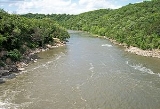
Blue Earth River
Encyclopedia
The Blue Earth River is a tributary
Tributary
A tributary or affluent is a stream or river that flows into a main stem river or a lake. A tributary does not flow directly into a sea or ocean...
of the Minnesota River
Minnesota River
The Minnesota River is a tributary of the Mississippi River, approximately 332 miles long, in the U.S. state of Minnesota. It drains a watershed of nearly , in Minnesota and about in South Dakota and Iowa....
, 108 miles (174 km) long, in southern Minnesota
Minnesota
Minnesota is a U.S. state located in the Midwestern United States. The twelfth largest state of the U.S., it is the twenty-first most populous, with 5.3 million residents. Minnesota was carved out of the eastern half of the Minnesota Territory and admitted to the Union as the thirty-second state...
in the United States
United States
The United States of America is a federal constitutional republic comprising fifty states and a federal district...
, it is also a Minnesota Department of Natural Resources designated Water Trail
Water trail
Water trails or Blueways are marked routes on navigable waterways such as rivers, lakes, canals and coastlines for people using small non-motorized boats such as kayaks, canoes, rafts, or rowboats. Some trails may be suitable for float tubing...
. Two of its headwaters tributaries, the Middle Branch Blue Earth River and the West Branch Blue Earth River, also flow for short distances in northern Iowa
Iowa
Iowa is a state located in the Midwestern United States, an area often referred to as the "American Heartland". It derives its name from the Ioway people, one of the many American Indian tribes that occupied the state at the time of European exploration. Iowa was a part of the French colony of New...
. By volume, it is the Minnesota River's largest tributary, accounting for 46% of the Minnesota's flow at the rivers' confluence in Mankato
Mankato, Minnesota
Mankato is a city in Blue Earth, Nicollet, and Le Sueur counties in the U.S. state of Minnesota. The population was 39,309 at the 2010 census, making it the fourth largest city in Minnesota outside of the Minneapolis-St. Paul metropolitan area. The county seat of Blue Earth County, it is located...
. Via the Minnesota River, the Blue Earth River is part of the watershed
Drainage basin
A drainage basin is an extent or an area of land where surface water from rain and melting snow or ice converges to a single point, usually the exit of the basin, where the waters join another waterbody, such as a river, lake, reservoir, estuary, wetland, sea, or ocean...
of the Mississippi River
Mississippi River
The Mississippi River is the largest river system in North America. Flowing entirely in the United States, this river rises in western Minnesota and meanders slowly southwards for to the Mississippi River Delta at the Gulf of Mexico. With its many tributaries, the Mississippi's watershed drains...
, draining an area of 3,486 square miles (9,029 km²) in an agricultural region. Ninety percent of the river's watershed is in Minnesota.
History
The river was named for former deposits of bluish-green clayClay
Clay is a general term including many combinations of one or more clay minerals with traces of metal oxides and organic matter. Geologic clay deposits are mostly composed of phyllosilicate minerals containing variable amounts of water trapped in the mineral structure.- Formation :Clay minerals...
, no longer visible, along the banks of the river. The stream was called Makato Osa Watapa by the Dakota Indians, meaning "the river where blue earth is gathered." The French
France
The French Republic , The French Republic , The French Republic , (commonly known as France , is a unitary semi-presidential republic in Western Europe with several overseas territories and islands located on other continents and in the Indian, Pacific, and Atlantic oceans. Metropolitan France...
explorer Pierre-Charles Le Sueur
Pierre-Charles Le Sueur
Pierre-Charles Le Sueur was a French fur trader and explorer in North America, recognized as the first known European to explore the Minnesota River valley....
established Fort L'Huillier
Fort L'Huillier
Fort L'Huillier was a short-lived fortification located on the Blue Earth River, just south of its confluence with the Minnesota River in southern Minnesota, United States....
near the river's mouth in 1700 for the purpose of mining the clay, either in the mistaken belief that the clay contained copper
Copper
Copper is a chemical element with the symbol Cu and atomic number 29. It is a ductile metal with very high thermal and electrical conductivity. Pure copper is soft and malleable; an exposed surface has a reddish-orange tarnish...
, or as a ruse to secure funding from his patrons for his fur trading
Fur trade
The fur trade is a worldwide industry dealing in the acquisition and sale of animal fur. Since the establishment of world market for in the early modern period furs of boreal, polar and cold temperate mammalian animals have been the most valued...
activities. The fort was abandoned the following year after an attack by the Fox tribe. In the 19th century, the geographer Joseph Nicollet
Joseph Nicollet
Joseph Nicolas Nicollet , also known as Jean-Nicolas Nicollet, was a French geographer and mathematician known for mapping the Upper Mississippi River basin during the 1830s....
found cavities from which the clay had been dug by Native Americans in the region, who used it as body paint
Body painting
Body painting, or sometimes bodypainting, is a form of body art. Unlike tattoo and other forms of body art, body painting is temporary, painted onto the human skin, and lasts for only several hours, or at most a couple of weeks. Body painting that is limited to the face is known as face painting...
; he found no evidence of Le Sueur's mines, nor of the fort.
Geography
The Blue Earth River is considered to begin at the confluence of its west and middle branches, approximately five miles (8 km) north of ElmoreElmore, Minnesota
Elmore is a city in Faribault County, Minnesota, United States. The population was 663 at the 2010 census. Elmore was the boyhood home of former vice president and presidential candidate Walter F. Mondale...
in southwestern Faribault County, Minnesota
Faribault County, Minnesota
As of the census of 2000, there were 16,181 people, 6,652 households, and 4,476 families residing in the county. The population density was 23 people per square mile . There were 7,247 housing units at an average density of 10 per square mile...
. The Middle Branch, 17 miles (27 km) long and sometimes known as the main stem of the river, rises in northwestern Winnebago County, Iowa
Winnebago County, Iowa
-2010 census:The 2010 census recorded a population of 10,866 in the county, with a population density of . There were 5,194 housing units, of which 4,597 were occupied.-2000 census:...
, approximately seven miles east of Rake
Rake, Iowa
Rake is a city in Winnebago County, Iowa, United States. The population was 227 at the 2000 census. Its ZIP Code is 50465.-History:Rake was founded by Arent A...
, and flows westwardly into Kossuth County, Iowa
Kossuth County, Iowa
-2010 census:The 2010 census recorded a population of 15,543 in the county, with a population density of . There were 7,486 housing units, of which 6,697 were occupied.-2000 census:...
, then northwardly into Faribault County. The West Branch, 15 miles (24 km) long, rises near Swea City
Swea City, Iowa
Swea City is a city in Kossuth County, Iowa, United States. The population was 642 at the 2000 census.-History:In February 1893, the town of Reynolds became known as Swea City. Swea City was petitioned for incorporation on December 11, 1894 with a population of 161...
in northern Kossuth County and flows northeastwardly into Faribault County. Both headwaters tributaries have been channelized
River engineering
River engineering is the process of planned human intervention in the course, characteristics or flow of a river with the intention of producing some defined benefit. People have intervened in the natural course and behaviour of rivers since before recorded history - to manage the water resources,...
for much of their courses. From their confluence the Blue Earth River flows northwardly in a winding course through eastern Faribault County into Blue Earth County
Blue Earth County, Minnesota
Blue Earth County is a county located in the U.S. state of Minnesota. As of 2010, the population was 64,013. Its county seat is Mankato.Blue Earth County is part of the Mankato–North Mankato Metropolitan Statistical Area.-Geography:...
, past the cities of Blue Earth
Blue Earth, Minnesota
As of the census of 2000, there were 3,621 people, 1,535 households, and 925 families residing in the city. The population density was 1,137.0 people per square mile . There were 1,666 housing units at an average density of 523.1 per square mile...
, Winnebago
Winnebago, Minnesota
As of the census of 2000, there were 1,487 people, 641 households, and 398 families residing in the city. The population density was 675.5 people per square mile . There were 705 housing units at an average density of 320.3 per square mile...
, and Vernon Center
Vernon Center, Minnesota
Vernon Center is a city in Blue Earth County, Minnesota, along the Blue Earth River. The population was 332 at the 2010 census. It is part of the Mankato–North Mankato Metropolitan Statistical Area.-Geography:...
, to Mankato
Mankato, Minnesota
Mankato is a city in Blue Earth, Nicollet, and Le Sueur counties in the U.S. state of Minnesota. The population was 39,309 at the 2010 census, making it the fourth largest city in Minnesota outside of the Minneapolis-St. Paul metropolitan area. The county seat of Blue Earth County, it is located...
, where it enters the Minnesota River from the south. Rapidan Dam, constructed for the purpose of hydroelectricity
Hydroelectricity
Hydroelectricity is the term referring to electricity generated by hydropower; the production of electrical power through the use of the gravitational force of falling or flowing water. It is the most widely used form of renewable energy...
generation in 1910, impounds the river 12 miles (19 km) upstream from its mouth; its reservoir filled with silt and mud soon after the dam's completion. The hydroelectric facility was later decommissioned but reactivated in 1984.
The Blue Earth River's largest tributaries are the Le Sueur River
Le Sueur River
The Le Sueur River is a tributary of the Blue Earth River, 111 miles long, in southern Minnesota in the United States. Via the Blue Earth and Minnesota Rivers, it is part of the watershed of the Mississippi River, draining an area of 1,089 square miles...
, which it collects three miles (5 km) upstream of its mouth; and the Watonwan River
Watonwan River
The Watonwan River is a tributary of the Blue Earth River, 113 miles long, in southern Minnesota in the United States. Via the Blue Earth and Minnesota Rivers, it is part of the watershed of the Mississippi River, draining an area of 878 square miles in an agricultural region...
, which it collects 16 miles (26 km) upstream of its mouth. The two rivers drain 31% and 24% of the Blue Earth's watershed, respectively. Tributaries of the river in its upper course include the East Branch Blue Earth River, 56 miles (90 km) long, which rises in southwestern Freeborn County
Freeborn County, Minnesota
As of the census of 2000, there were 32,584 people, 13,356 households, and 9,015 families residing in the county. The population density was 46 people per square mile . There were 13,996 housing units at an average density of 20 per square mile...
and flows westwardly through Faribault County to the city of Blue Earth; and Elm Creek, 75 miles (121 km) long, which rises in northeastern Jackson County
Jackson County, Minnesota
As of the census of 2000, there were 11,268 people, 4,556 households, and 3,116 families residing in the county. The population density was 16 people per square mile . There were 5,092 housing units at an average density of 7 per square mile...
and flows eastwardly through Martin County
Martin County, Minnesota
As of the census of 2000, there were 21,802 people, 9,067 households, and 6,047 families residing in the county. The population density was 31 people per square mile . There were 9,800 housing units at an average density of 14 per square mile...
into northeastern Faribault County, where it joins the Blue Earth River near Winnebago.
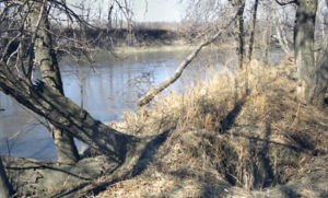
The Blue Earth River flows in most of its course through till plain
Till plain
A till plain is an extensive flat plain of glacial till that forms when a sheet of ice becomes detached from the main body of a glacier and melts in place depositing the sediments it carried. A till plain with irregular topography is referred to as a ground moraine.-See also:*Glacial till plains...
s and the plain of a former glacial lake
Glacial lake
A glacial lake is a lake with origins in a melted glacier. Near the end of the last glacial period, roughly 10,000 years ago, glaciers began to retreat. A retreating glacier often left behind large deposits of ice in hollows between drumlins or hills. As the ice age ended, these melted to create...
. The lower (northern) part of the river's watershed was historically covered by the Big Woods
Big Woods
Big Woods refers to a type of temperate hardwood forest ecoregion found in south-central Minnesota. "Big Woods" is a direct translation of the name given to the region by French explorers: Grand Bois.-Trees:...
, a tract of hardwood
Hardwood
Hardwood is wood from angiosperm trees . It may also be used for those trees themselves: these are usually broad-leaved; in temperate and boreal latitudes they are mostly deciduous, but in tropics and subtropics mostly evergreen.Hardwood contrasts with softwood...
s that has since been largely converted to agricultural use; segments of the woodland extended southward along the riparian
Riparian zone
A riparian zone or riparian area is the interface between land and a river or stream. Riparian is also the proper nomenclature for one of the fifteen terrestrial biomes of the earth. Plant habitats and communities along the river margins and banks are called riparian vegetation, characterized by...
corridors of the Blue Earth River and its tributaries. In its lower course below Rapidan Dam, the river flows through a wooded gorge in the valley of the Minnesota River; this section is a popular canoeing
Canoeing
Canoeing is an outdoor activity that involves a special kind of canoe.Open canoes may be 'poled' , sailed, 'lined and tracked' or even 'gunnel-bobbed'....
route.
According to the Minnesota Pollution Control Agency, approximately 84% of the Blue Earth River's watershed is used for agricultural cultivation, primarily that of corn
Maize
Maize known in many English-speaking countries as corn or mielie/mealie, is a grain domesticated by indigenous peoples in Mesoamerica in prehistoric times. The leafy stalk produces ears which contain seeds called kernels. Though technically a grain, maize kernels are used in cooking as a vegetable...
and soybean
Soybean
The soybean or soya bean is a species of legume native to East Asia, widely grown for its edible bean which has numerous uses...
s. The river is one of the most polluted
Water pollution
Water pollution is the contamination of water bodies . Water pollution occurs when pollutants are discharged directly or indirectly into water bodies without adequate treatment to remove harmful compounds....
in Minnesota, with elevated levels of sediment
Sediment
Sediment is naturally occurring material that is broken down by processes of weathering and erosion, and is subsequently transported by the action of fluids such as wind, water, or ice, and/or by the force of gravity acting on the particle itself....
, bacteria
Bacteria
Bacteria are a large domain of prokaryotic microorganisms. Typically a few micrometres in length, bacteria have a wide range of shapes, ranging from spheres to rods and spirals...
, nitrate
Nitrate
The nitrate ion is a polyatomic ion with the molecular formula NO and a molecular mass of 62.0049 g/mol. It is the conjugate base of nitric acid, consisting of one central nitrogen atom surrounded by three identically-bonded oxygen atoms in a trigonal planar arrangement. The nitrate ion carries a...
s, phosphorus
Phosphorus
Phosphorus is the chemical element that has the symbol P and atomic number 15. A multivalent nonmetal of the nitrogen group, phosphorus as a mineral is almost always present in its maximally oxidized state, as inorganic phosphate rocks...
, mercury
Mercury (element)
Mercury is a chemical element with the symbol Hg and atomic number 80. It is also known as quicksilver or hydrargyrum...
, PCBs
Polychlorinated biphenyl
Polychlorinated biphenyls are a class of organic compounds with 2 to 10 chlorine atoms attached to biphenyl, which is a molecule composed of two benzene rings. The chemical formula for PCBs is C12H10-xClx...
, and pesticide
Pesticide
Pesticides are substances or mixture of substances intended for preventing, destroying, repelling or mitigating any pest.A pesticide may be a chemical unicycle, biological agent , antimicrobial, disinfectant or device used against any pest...
s, contributed in part by runoff
Surface runoff
Surface runoff is the water flow that occurs when soil is infiltrated to full capacity and excess water from rain, meltwater, or other sources flows over the land. This is a major component of the water cycle. Runoff that occurs on surfaces before reaching a channel is also called a nonpoint source...
in the watershed. Fecal coliforms
Fecal coliforms
A fecal coliform is a facultatively-anaerobic, rod-shaped, gram-negative, non-sporulating bacterium. Fecal coliforms are capable of growth in the presence of bile salts or similar surface agents, are oxidase negative, and produce acid and gas from lactose within 48 hours at 44 ± 0.5°C.Coliform...
, contributed by manure
Manure
Manure is organic matter used as organic fertilizer in agriculture. Manures contribute to the fertility of the soil by adding organic matter and nutrients, such as nitrogen, that are trapped by bacteria in the soil...
fertilizers, livestock waste, substandard septic tank
Septic tank
A septic tank is a key component of the septic system, a small-scale sewage treatment system common in areas with no connection to main sewage pipes provided by local governments or private corporations...
s and outdated sewer
Sanitary sewer
A sanitary sewer is a separate underground carriage system specifically for transporting sewage from houses and commercial buildings to treatment or disposal. Sanitary sewers serving industrial areas also carry industrial wastewater...
systems, are often present in the river at levels considered by the state government to be unsafe for swimming.
Flow rate
The United States Geological SurveyUnited States Geological Survey
The United States Geological Survey is a scientific agency of the United States government. The scientists of the USGS study the landscape of the United States, its natural resources, and the natural hazards that threaten it. The organization has four major science disciplines, concerning biology,...
operates a stream gauge
Stream gauge
A stream gauge, stream gage or gauging station is a location used by hydrologists or environmental scientists to monitor and test terrestrial bodies of water. Hydrometric measurements of water surface elevation and/or volumetric discharge are generally taken and observations of biota may also be...
on the Blue Earth River below Rapidan Dam in Rapidan Township
Rapidan Township, Minnesota
Rapidan Township is a township in Blue Earth County, Minnesota, United States. The population was 1,061 as of the 2000 census.-Geography:: Township 107 North, Range 27 West, Fifth Meridian, 22,819 Acres...
, downstream of the mouth of the Watonwan River and upstream of the mouth of the Le Sueur River, and 12 miles (19 km) upstream from the river's mouth. The annual mean flow of the river at the gauge between 1909 and 2005 was 1,076 cubic feet per second (30 m³/s). The highest recorded flow during the period was 43,100 ft³/s (1,220 m³/s) on April 9, 1965. The lowest recorded flow was 6.9 ft³/s (0.2 m³/s) on October 12, 1955.