
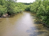
Watonwan River
Encyclopedia
The Watonwan River is a tributary
of the Blue Earth River
, 113 miles (182 km) long, in southern Minnesota
in the United States
. Via the Blue Earth and Minnesota
Rivers, it is part of the watershed
of the Mississippi River
, draining an area of 878 square miles (2,274 km²) in an agricultural region. The Watonwan drains about a quarter of the Blue Earth River's watershed.
The river was the site of the capture of Bob
, Cole
and Jim Younger
(members of the James-Younger gang
) near Madelia
in 1876.
, approximately three miles (5 km) southwest of Jeffers
in central Cottonwood County
, and flows generally eastwardly across flat till plain
s through northern Watonwan
and western Blue Earth
Counties, past the city of Madelia
. It flows into the Blue Earth River approximately eight miles (13 km) southwest of Mankato
and 16 miles (26 km) upstream of the Blue Earth's confluence with the Minnesota River.
The river's largest tributaries are its north and south forks. The South Fork Watonwan River, 73 miles (118 km) long, rises in southeastern Cottonwood County and initially flows eastwardly into southern Watonwan County, briefly entering Martin County
and passing Odin
; then northeastwardly through eastern Watonwan County to its confluence with the Watonwan River upstream of Madelia. The North Fork Watonwan River, 39 miles (63 km) long, rises in Cottonwood County and flows eastwardly into northern Watonwan County, joining the Watonwan River about a mile (2 km) southeast of La Salle
.
Approximately 84% of the larger watershed of the Blue Earth River, which includes that of the Watonwan River, is used for agricultural cultivation, primarily that of corn
and soybean
s. Small lakes and wetlands in the Watonwan watershed provide significant habitat for Minnesota's waterfowl
population, though many stretches of the river and its tributaries have been subject to ditch
ing and channelization
for agricultural production and localized flood reduction.
's stream gauge
near the community of Garden City in Garden City Township
, 7.3 miles (11.8 km) upstream from the river's mouth, the annual mean flow of the river between 1940 and 2005 was 391 cubic feet per second (11 m³/s). The highest recorded flow during the period was 13,900 ft³/s (394 m³/s) on June 20, 1993. The lowest recorded flow, caused by an ice dam
, was 1.8 ft³/s (0 m³/s) on December 24, 1989.
Tributary
A tributary or affluent is a stream or river that flows into a main stem river or a lake. A tributary does not flow directly into a sea or ocean...
of the Blue Earth River
Blue Earth River
The Blue Earth River is a tributary of the Minnesota River, 108 miles long, in southern Minnesota in the United States, it is also a Minnesota Department of Natural Resources designated Water Trail. Two of its headwaters tributaries, the Middle Branch Blue Earth River and the West Branch...
, 113 miles (182 km) long, in southern Minnesota
Minnesota
Minnesota is a U.S. state located in the Midwestern United States. The twelfth largest state of the U.S., it is the twenty-first most populous, with 5.3 million residents. Minnesota was carved out of the eastern half of the Minnesota Territory and admitted to the Union as the thirty-second state...
in the United States
United States
The United States of America is a federal constitutional republic comprising fifty states and a federal district...
. Via the Blue Earth and Minnesota
Minnesota River
The Minnesota River is a tributary of the Mississippi River, approximately 332 miles long, in the U.S. state of Minnesota. It drains a watershed of nearly , in Minnesota and about in South Dakota and Iowa....
Rivers, it is part of the watershed
Drainage basin
A drainage basin is an extent or an area of land where surface water from rain and melting snow or ice converges to a single point, usually the exit of the basin, where the waters join another waterbody, such as a river, lake, reservoir, estuary, wetland, sea, or ocean...
of the Mississippi River
Mississippi River
The Mississippi River is the largest river system in North America. Flowing entirely in the United States, this river rises in western Minnesota and meanders slowly southwards for to the Mississippi River Delta at the Gulf of Mexico. With its many tributaries, the Mississippi's watershed drains...
, draining an area of 878 square miles (2,274 km²) in an agricultural region. The Watonwan drains about a quarter of the Blue Earth River's watershed.
The river was the site of the capture of Bob
Bob Younger
Robert Ewing "Bob" Younger was an American criminal and outlaw, the younger brother of Cole, Jim and John Younger , he was a member of the James-Younger gang.-Life:...
, Cole
Cole Younger
Thomas Coleman "Cole" Younger was an American Confederate guerrilla during the American Civil War and later an outlaw with the James-Younger gang...
and Jim Younger
Jim Younger
James Hardin "Jim" Younger was a notable American outlaw and member of the James-Younger gang. He was the brother of Cole, John and Bob Younger-Life:...
(members of the James-Younger gang
James-Younger gang
The James-Younger Gang was a notable 19th-century gang of American outlaws that included Jesse James.The gang was centered in the state of Missouri. Membership fluctuated from robbery to robbery, as the outlaws' raids were usually separated by many months...
) near Madelia
Madelia, Minnesota
As of the census of 2000, there were 2,340 people, 911 households, and 571 families residing in the city. The population density was 1,876.4 people per square mile . There were 1,000 housing units at an average density of 801.9 per square mile...
in 1876.
Geography
The Watonwan River rises in Amboy TownshipAmboy Township, Minnesota
Amboy Township is a township in Cottonwood County, Minnesota, United States. The population was 172 at the 2000 census.-Geography:According to the United States Census Bureau, the township has a total area of , all of it land.-Demographics:...
, approximately three miles (5 km) southwest of Jeffers
Jeffers, Minnesota
Jeffers is a city in Amboy Township, Cottonwood County, Minnesota, United States. The population was 369 at the 2010 census.Minnesota State Highway 30 and County Highway 4 are two of the main routes in the community. U.S. Route 71 is nearby.-Geography:...
in central Cottonwood County
Cottonwood County, Minnesota
Cottonwood County is a county located in the U.S. state of Minnesota. As of 2010, the population was 11,687. Its county seat is Windom.-History:...
, and flows generally eastwardly across flat till plain
Till plain
A till plain is an extensive flat plain of glacial till that forms when a sheet of ice becomes detached from the main body of a glacier and melts in place depositing the sediments it carried. A till plain with irregular topography is referred to as a ground moraine.-See also:*Glacial till plains...
s through northern Watonwan
Watonwan County, Minnesota
As of the census of 2000, there were 11,876 people, 4,627 households, and 3,141 families residing in the county. The population density was 27 people per square mile . There were 5,036 housing units at an average density of 12 per square mile...
and western Blue Earth
Blue Earth County, Minnesota
Blue Earth County is a county located in the U.S. state of Minnesota. As of 2010, the population was 64,013. Its county seat is Mankato.Blue Earth County is part of the Mankato–North Mankato Metropolitan Statistical Area.-Geography:...
Counties, past the city of Madelia
Madelia, Minnesota
As of the census of 2000, there were 2,340 people, 911 households, and 571 families residing in the city. The population density was 1,876.4 people per square mile . There were 1,000 housing units at an average density of 801.9 per square mile...
. It flows into the Blue Earth River approximately eight miles (13 km) southwest of Mankato
Mankato, Minnesota
Mankato is a city in Blue Earth, Nicollet, and Le Sueur counties in the U.S. state of Minnesota. The population was 39,309 at the 2010 census, making it the fourth largest city in Minnesota outside of the Minneapolis-St. Paul metropolitan area. The county seat of Blue Earth County, it is located...
and 16 miles (26 km) upstream of the Blue Earth's confluence with the Minnesota River.
The river's largest tributaries are its north and south forks. The South Fork Watonwan River, 73 miles (118 km) long, rises in southeastern Cottonwood County and initially flows eastwardly into southern Watonwan County, briefly entering Martin County
Martin County, Minnesota
As of the census of 2000, there were 21,802 people, 9,067 households, and 6,047 families residing in the county. The population density was 31 people per square mile . There were 9,800 housing units at an average density of 14 per square mile...
and passing Odin
Odin, Minnesota
Odin is a city in Watonwan County, Minnesota, United States, along the South Fork of the Watonwan River. The population was 106 at the 2010 census.-Geography:According to the United States Census Bureau, the city has a total area of , all of it land....
; then northeastwardly through eastern Watonwan County to its confluence with the Watonwan River upstream of Madelia. The North Fork Watonwan River, 39 miles (63 km) long, rises in Cottonwood County and flows eastwardly into northern Watonwan County, joining the Watonwan River about a mile (2 km) southeast of La Salle
La Salle, Minnesota
La Salle is a city in Watonwan County, Minnesota, United States. The population was 87 at the 2010 census.-Geography:According to the United States Census Bureau, the city has a total area of , all of it land.-Demographics:...
.
Approximately 84% of the larger watershed of the Blue Earth River, which includes that of the Watonwan River, is used for agricultural cultivation, primarily that of corn
Maize
Maize known in many English-speaking countries as corn or mielie/mealie, is a grain domesticated by indigenous peoples in Mesoamerica in prehistoric times. The leafy stalk produces ears which contain seeds called kernels. Though technically a grain, maize kernels are used in cooking as a vegetable...
and soybean
Soybean
The soybean or soya bean is a species of legume native to East Asia, widely grown for its edible bean which has numerous uses...
s. Small lakes and wetlands in the Watonwan watershed provide significant habitat for Minnesota's waterfowl
Waterfowl
Waterfowl are certain wildfowl of the order Anseriformes, especially members of the family Anatidae, which includes ducks, geese, and swans....
population, though many stretches of the river and its tributaries have been subject to ditch
Ditch
A ditch is usually defined as a small to moderate depression created to channel water.In Anglo-Saxon, the word dïc already existed and was pronounced 'deek' in northern England and 'deetch' in the south. The origins of the word lie in digging a trench and forming the upcast soil into a bank...
ing and channelization
River engineering
River engineering is the process of planned human intervention in the course, characteristics or flow of a river with the intention of producing some defined benefit. People have intervened in the natural course and behaviour of rivers since before recorded history - to manage the water resources,...
for agricultural production and localized flood reduction.
Flow rate
At the United States Geological SurveyUnited States Geological Survey
The United States Geological Survey is a scientific agency of the United States government. The scientists of the USGS study the landscape of the United States, its natural resources, and the natural hazards that threaten it. The organization has four major science disciplines, concerning biology,...
's stream gauge
Stream gauge
A stream gauge, stream gage or gauging station is a location used by hydrologists or environmental scientists to monitor and test terrestrial bodies of water. Hydrometric measurements of water surface elevation and/or volumetric discharge are generally taken and observations of biota may also be...
near the community of Garden City in Garden City Township
Garden City Township, Minnesota
Garden City Township is a township in Blue Earth County, Minnesota, United States. The population was 700 as of the 2000 census.The township is home to the Blue Earth County Fair.-Geography:...
, 7.3 miles (11.8 km) upstream from the river's mouth, the annual mean flow of the river between 1940 and 2005 was 391 cubic feet per second (11 m³/s). The highest recorded flow during the period was 13,900 ft³/s (394 m³/s) on June 20, 1993. The lowest recorded flow, caused by an ice dam
Ice dam
An ice dam occurs when water builds up behind a blockage of ice. Ice dams can occur in various ways.-Caused by a glacier:Sometimes a glacier flows down a valley to a confluence where the other branch carries an unfrozen river...
, was 1.8 ft³/s (0 m³/s) on December 24, 1989.