
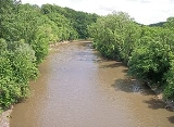
Le Sueur River
Encyclopedia
The Le Sueur River is a tributary
of the Blue Earth River
, 111 miles (178 km) long, in southern Minnesota
in the United States
. Via the Blue Earth and Minnesota
Rivers, it is part of the watershed
of the Mississippi River
, draining an area of 1,089 square miles (2,280 km²). It is the largest tributary of the Blue Earth River, draining 31% of its watershed.
in northwestern Freeborn County
and flows initially northwardly, through the southwestern extremity of Steele County
into Waseca County
, then westwardly in a winding course into Blue Earth County
, passing through St. Clair
. It flows into the Blue Earth River southwest of Mankato
, approximately three miles (5 km) upstream of the Blue Earth's mouth at the Minnesota River. Its largest tributaries are the Cobb
and Maple
Rivers, which it collects from the south approximately six and eight miles (10 km/13 km) upstream of its mouth, respectively. A minor tributary of the Le Sueur River in Waseca and Steele Counties is known as the Little Le Sueur River.
The Le Sueur River flows in most of its course on till plain
s and on the plain of a former glacial lake
, through deeply incised ravine
s in its lower course. Extensions of the Big Woods
, a tract of hardwood
s that has since been largely converted to agricultural use, historically followed the river's riparian
corridor southward. According to the Minnesota Pollution Control Agency, approximately 84% of the larger watershed of the Blue Earth River is used for agricultural cultivation, primarily that of corn
and soybean
s.
's stream gauge
near the community of Rapidan, two miles (3 km) upstream from the river's mouth, the annual mean flow of the river between 1940 and 2005 was 549 cubic feet per second (16 m³/s). The highest recorded flow during the period was 24,700 ft³/s (699 m³/s) on April 8, 1965. The lowest recorded flow was 1.6 ft³/s (0 m³/s) on February 9, 1959.
Tributary
A tributary or affluent is a stream or river that flows into a main stem river or a lake. A tributary does not flow directly into a sea or ocean...
of the Blue Earth River
Blue Earth River
The Blue Earth River is a tributary of the Minnesota River, 108 miles long, in southern Minnesota in the United States, it is also a Minnesota Department of Natural Resources designated Water Trail. Two of its headwaters tributaries, the Middle Branch Blue Earth River and the West Branch...
, 111 miles (178 km) long, in southern Minnesota
Minnesota
Minnesota is a U.S. state located in the Midwestern United States. The twelfth largest state of the U.S., it is the twenty-first most populous, with 5.3 million residents. Minnesota was carved out of the eastern half of the Minnesota Territory and admitted to the Union as the thirty-second state...
in the United States
United States
The United States of America is a federal constitutional republic comprising fifty states and a federal district...
. Via the Blue Earth and Minnesota
Minnesota River
The Minnesota River is a tributary of the Mississippi River, approximately 332 miles long, in the U.S. state of Minnesota. It drains a watershed of nearly , in Minnesota and about in South Dakota and Iowa....
Rivers, it is part of the watershed
Drainage basin
A drainage basin is an extent or an area of land where surface water from rain and melting snow or ice converges to a single point, usually the exit of the basin, where the waters join another waterbody, such as a river, lake, reservoir, estuary, wetland, sea, or ocean...
of the Mississippi River
Mississippi River
The Mississippi River is the largest river system in North America. Flowing entirely in the United States, this river rises in western Minnesota and meanders slowly southwards for to the Mississippi River Delta at the Gulf of Mexico. With its many tributaries, the Mississippi's watershed drains...
, draining an area of 1,089 square miles (2,280 km²). It is the largest tributary of the Blue Earth River, draining 31% of its watershed.
Course
The Le Sueur River rises in Hartland TownshipHartland Township, Minnesota
Hartland Township is a township in Freeborn County, Minnesota, United States. The population was 298 at the 2000 census.-Geography:According to the United States Census Bureau, the township has a total area of , of which, of it is land and of it is water.-Demographics:As of the census of 2000,...
in northwestern Freeborn County
Freeborn County, Minnesota
As of the census of 2000, there were 32,584 people, 13,356 households, and 9,015 families residing in the county. The population density was 46 people per square mile . There were 13,996 housing units at an average density of 20 per square mile...
and flows initially northwardly, through the southwestern extremity of Steele County
Steele County, Minnesota
As of the census of 2000, there were 33,680 people, 12,846 households, and 9,082 families residing in the county. The population density was 78 people per square mile . There were 13,306 housing units at an average density of 31 per square mile...
into Waseca County
Waseca County, Minnesota
-External links:**...
, then westwardly in a winding course into Blue Earth County
Blue Earth County, Minnesota
Blue Earth County is a county located in the U.S. state of Minnesota. As of 2010, the population was 64,013. Its county seat is Mankato.Blue Earth County is part of the Mankato–North Mankato Metropolitan Statistical Area.-Geography:...
, passing through St. Clair
St. Clair, Minnesota
St. Clair is a city in Blue Earth County, Minnesota, along the Le Sueur River. The population was 868 at the 2010 census. It is part of the Mankato–North Mankato Metropolitan Statistical Area.-Geography:...
. It flows into the Blue Earth River southwest of Mankato
Mankato, Minnesota
Mankato is a city in Blue Earth, Nicollet, and Le Sueur counties in the U.S. state of Minnesota. The population was 39,309 at the 2010 census, making it the fourth largest city in Minnesota outside of the Minneapolis-St. Paul metropolitan area. The county seat of Blue Earth County, it is located...
, approximately three miles (5 km) upstream of the Blue Earth's mouth at the Minnesota River. Its largest tributaries are the Cobb
Cobb River (Minnesota)
The Cobb River and its tributary the Little Cobb River are small rivers in southern Minnesota in the United States. The Cobb River is a tributary of the Le Sueur River...
and Maple
Maple River (Minnesota)
The Maple River is a tributary of the Le Sueur River in southern Minnesota in the United States. Via the Le Sueur, Blue Earth and Minnesota rivers, it is part of the watershed of the Mississippi River.-Course:...
Rivers, which it collects from the south approximately six and eight miles (10 km/13 km) upstream of its mouth, respectively. A minor tributary of the Le Sueur River in Waseca and Steele Counties is known as the Little Le Sueur River.
The Le Sueur River flows in most of its course on till plain
Till plain
A till plain is an extensive flat plain of glacial till that forms when a sheet of ice becomes detached from the main body of a glacier and melts in place depositing the sediments it carried. A till plain with irregular topography is referred to as a ground moraine.-See also:*Glacial till plains...
s and on the plain of a former glacial lake
Glacial lake
A glacial lake is a lake with origins in a melted glacier. Near the end of the last glacial period, roughly 10,000 years ago, glaciers began to retreat. A retreating glacier often left behind large deposits of ice in hollows between drumlins or hills. As the ice age ended, these melted to create...
, through deeply incised ravine
Ravine
A ravine is a landform narrower than a canyon and is often the product of streamcutting erosion. Ravines are typically classified as larger in scale than gullies, although smaller than valleys. A ravine is generally a fluvial slope landform of relatively steep sides, on the order of twenty to...
s in its lower course. Extensions of the Big Woods
Big Woods
Big Woods refers to a type of temperate hardwood forest ecoregion found in south-central Minnesota. "Big Woods" is a direct translation of the name given to the region by French explorers: Grand Bois.-Trees:...
, a tract of hardwood
Hardwood
Hardwood is wood from angiosperm trees . It may also be used for those trees themselves: these are usually broad-leaved; in temperate and boreal latitudes they are mostly deciduous, but in tropics and subtropics mostly evergreen.Hardwood contrasts with softwood...
s that has since been largely converted to agricultural use, historically followed the river's riparian
Riparian zone
A riparian zone or riparian area is the interface between land and a river or stream. Riparian is also the proper nomenclature for one of the fifteen terrestrial biomes of the earth. Plant habitats and communities along the river margins and banks are called riparian vegetation, characterized by...
corridor southward. According to the Minnesota Pollution Control Agency, approximately 84% of the larger watershed of the Blue Earth River is used for agricultural cultivation, primarily that of corn
Maize
Maize known in many English-speaking countries as corn or mielie/mealie, is a grain domesticated by indigenous peoples in Mesoamerica in prehistoric times. The leafy stalk produces ears which contain seeds called kernels. Though technically a grain, maize kernels are used in cooking as a vegetable...
and soybean
Soybean
The soybean or soya bean is a species of legume native to East Asia, widely grown for its edible bean which has numerous uses...
s.
Flow rate
At the United States Geological SurveyUnited States Geological Survey
The United States Geological Survey is a scientific agency of the United States government. The scientists of the USGS study the landscape of the United States, its natural resources, and the natural hazards that threaten it. The organization has four major science disciplines, concerning biology,...
's stream gauge
Stream gauge
A stream gauge, stream gage or gauging station is a location used by hydrologists or environmental scientists to monitor and test terrestrial bodies of water. Hydrometric measurements of water surface elevation and/or volumetric discharge are generally taken and observations of biota may also be...
near the community of Rapidan, two miles (3 km) upstream from the river's mouth, the annual mean flow of the river between 1940 and 2005 was 549 cubic feet per second (16 m³/s). The highest recorded flow during the period was 24,700 ft³/s (699 m³/s) on April 8, 1965. The lowest recorded flow was 1.6 ft³/s (0 m³/s) on February 9, 1959.