
Ashby's Gap
Encyclopedia
Ashby Gap, more commonly known as Ashby's Gap is a wind gap
in the Blue Ridge Mountains
on the border of Clarke County
, Loudoun County
and Fauquier County
in Virginia
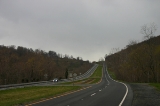
. The gap is traversed by U.S. Route 50
. The Appalachian trail
also passes across the gap.
, which flows to the north, west of the gap. To the west lies Virginia's Shenandoah Valley
, which is part of the Great Appalachian Valley
and to the east lies Virginia's Piedmont
region. Just south of this gap is Sky Meadows State Park
.
The gap serves as the western demarcation point for the border between Fauquier and Loudoun, originally marked by a "double-bodied poplar tree standing in or near the middle of the thoroughfare of Ashby's Gap on the top of the Blue Ridge." The tree has since died and the thoroughfare, modern day U.S. Route 50
, realigned to the south so that Loudoun County is not entered when traveling through the gap.
at the eastern entrance to the gap. Later it came to be called Ashby's Gap. In the early 19th century the Ashby's Gap Turnpike was completed from Aldie
to the crest of the gap where it met up with the Millwod Pike. Those roads in turn became the modern U.S. Route 50 in 1922 when the Commonwealth took possession of them.
, Ashby's Gap was often used by the Confederate Army and Union Army
in the several Shenandoah Valley campaigns. The nearby ridgetop was used by the Confederate Signal Corps.
In July 1861 Brigadier General Thomas J. "Stonewall" Jackson
lead his 1st Virginia Brigade
through Ashby's Gap on his way from Winchester
to Piedmont Station (present day Delaplane
) where they boarded railcars on the Manassas Gap Railroad
and were taken to Manassas Junction where the First Battle of Manassas was underway. This marked the first use of railroads for troop movement in a war.
In June 1863, Confederate Major General J.E.B. Stuart
's cavalry
held this gap to prevent elements from the Union Army under Major General Joseph Hooker
from interfering with General Robert E. Lee
's army as it marched north toward Pennsylvania
in the Gettysburg Campaign
.
On July 19, 1864 a small cavalry battle, sometimes referred to as the Battle of Ashby's Gap, was fought at the gap when Union cavalry attempted to force passage across the gap and Shenandoah River in an attempt to attack the rear of Confederate Lieutenant General Jubal Early's army and supply trains as he repositioned himself near Berryville
as part of the Valley Campaigns of 1864
.
Wind gap
A wind gap is a valley through which a waterway once flowed, but is now dry as a result of stream capture. A water gap is a similar feature, but one in which a waterway still flows...
in the Blue Ridge Mountains
Blue Ridge Mountains
The Blue Ridge Mountains are a physiographic province of the larger Appalachian Mountains range. This province consists of northern and southern physiographic regions, which divide near the Roanoke River gap. The mountain range is located in the eastern United States, starting at its southern-most...
on the border of Clarke County
Clarke County, Virginia
Clarke County is a county in the Commonwealth of Virginia. As of 2010, the population was 14,034. Its county seat is Berryville.-History:Clarke County was established in 1836 by Thomas Fairfax, 6th Lord Fairfax of Cameron who built a home, Greenway Court, on part of his 5 million acre property,...
, Loudoun County
Loudoun County, Virginia
Loudoun County is a county located in the Commonwealth of Virginia, and is part of the Washington Metropolitan Area. As of the 2010 U.S. Census, the county is estimated to be home to 312,311 people, an 84 percent increase over the 2000 figure of 169,599. That increase makes the county the fourth...
and Fauquier County
Fauquier County, Virginia
As of the census of 2000, there were 55,139 people, 19,842 households, and 15,139 families residing in the county. The population density was 85 people per square mile . There were 21,046 housing units at an average density of 32 per square mile...
in Virginia
Virginia
The Commonwealth of Virginia , is a U.S. state on the Atlantic Coast of the Southern United States. Virginia is nicknamed the "Old Dominion" and sometimes the "Mother of Presidents" after the eight U.S. presidents born there...
. The gap is traversed by U.S. Route 50
U.S. Route 50
U.S. Route 50 is a major east–west route of the U.S. Highway system, stretching just over from Ocean City, Maryland on the Atlantic Ocean to West Sacramento, California. Until 1972, when it was replaced by Interstate Highways west of the Sacramento area, it extended to San Francisco, near...
. The Appalachian trail
Appalachian Trail
The Appalachian National Scenic Trail, generally known as the Appalachian Trail or simply the AT, is a marked hiking trail in the eastern United States extending between Springer Mountain in Georgia and Mount Katahdin in Maine. It is approximately long...
also passes across the gap.
Geography
At 1027 feet (313 m) the gap is 500 feet (152.4 m) below the adjacent ridge line to the north, and 700 feet (213.4 m) above the Shenandoah RiverShenandoah River
The Shenandoah River is a tributary of the Potomac River, long with two forks approximately long each, in the U.S. states of Virginia and West Virginia...
, which flows to the north, west of the gap. To the west lies Virginia's Shenandoah Valley
Shenandoah Valley
The Shenandoah Valley is both a geographic valley and cultural region of western Virginia and West Virginia in the United States. The valley is bounded to the east by the Blue Ridge Mountains, to the west by the eastern front of the Ridge-and-Valley Appalachians , to the north by the Potomac River...
, which is part of the Great Appalachian Valley
Great Appalachian Valley
The Great Valley, also called the Great Appalachian Valley or Great Valley Region, is one of the major landform features of eastern North America. It is a gigantic trough — a chain of valley lowlands — and the central feature of the Appalachian Mountain system...
and to the east lies Virginia's Piedmont
Piedmont (United States)
The Piedmont is a plateau region located in the eastern United States between the Atlantic Coastal Plain and the main Appalachian Mountains, stretching from New Jersey in the north to central Alabama in the south. The Piedmont province is a physiographic province of the larger Appalachian division...
region. Just south of this gap is Sky Meadows State Park
Sky Meadows State Park
Sky Meadows State Park is a park in the Virginia state park system. It is located in extreme northwest Fauquier County, Virginia in the Blue Ridge Mountains, near Paris, Virginia. It is about an hour outside of the Washington, D.C. metro region....
.
The gap serves as the western demarcation point for the border between Fauquier and Loudoun, originally marked by a "double-bodied poplar tree standing in or near the middle of the thoroughfare of Ashby's Gap on the top of the Blue Ridge." The tree has since died and the thoroughfare, modern day U.S. Route 50
U.S. Route 50
U.S. Route 50 is a major east–west route of the U.S. Highway system, stretching just over from Ocean City, Maryland on the Atlantic Ocean to West Sacramento, California. Until 1972, when it was replaced by Interstate Highways west of the Sacramento area, it extended to San Francisco, near...
, realigned to the south so that Loudoun County is not entered when traveling through the gap.
History
The earliest known use of the gap was as part of a trail of the Native Americans. Upon European colonization, the gap was first referred to as the "Upper Thoroughfare of the Blue Ridge". It was later named "Ashby's Bent" when Thomas Ashby received lands along Goose Creek, and settled Paris, VirginiaParis, Virginia
Paris is a village in Fauquier County, Virginia, United States. Located in Virginia's hunt country, it was established in a strategic spot at the eastern base of Ashby Gap along U.S. Route 17 and U.S. Route 50. Paris has a population of 51. There is one church in Paris, the Trinity United...
at the eastern entrance to the gap. Later it came to be called Ashby's Gap. In the early 19th century the Ashby's Gap Turnpike was completed from Aldie
Aldie, Virginia
Aldie is an unincorporated village located on the John Mosby Highway between Gilbert's Corner and Middleburg in Loudoun County, Virginia. It is located in a gap between the Catoctin Mountain and Bull Run Mountain, through which the Little River flows...
to the crest of the gap where it met up with the Millwod Pike. Those roads in turn became the modern U.S. Route 50 in 1922 when the Commonwealth took possession of them.
Importance during American Civil War
During the American Civil WarAmerican Civil War
The American Civil War was a civil war fought in the United States of America. In response to the election of Abraham Lincoln as President of the United States, 11 southern slave states declared their secession from the United States and formed the Confederate States of America ; the other 25...
, Ashby's Gap was often used by the Confederate Army and Union Army
Union Army
The Union Army was the land force that fought for the Union during the American Civil War. It was also known as the Federal Army, the U.S. Army, the Northern Army and the National Army...
in the several Shenandoah Valley campaigns. The nearby ridgetop was used by the Confederate Signal Corps.
In July 1861 Brigadier General Thomas J. "Stonewall" Jackson
Stonewall Jackson
ຄຽשת״ׇׂׂׂׂ֣|birth_place= Clarksburg, Virginia |death_place=Guinea Station, Virginia|placeofburial=Stonewall Jackson Memorial CemeteryLexington, Virginia|placeofburial_label= Place of burial|image=...
lead his 1st Virginia Brigade
Stonewall Brigade
The Stonewall Brigade of the Confederate Army during the American Civil War, was a famous combat unit in United States military history. It was trained and first led by General Thomas J. "Stonewall" Jackson, a professor from Virginia Military Institute...
through Ashby's Gap on his way from Winchester
Winchester, Virginia
Winchester is an independent city located in the northwestern portion of the Commonwealth of Virginia in the USA. The city's population was 26,203 according to the 2010 Census...
to Piedmont Station (present day Delaplane
Delaplane, Virginia
Delaplane is a small unincorporated village in Fauquier County, Virginia, located approximately due west of Washington, D.C.. Delaplane is situated along U.S. Route 17 and Interstate 66; bordering Upperville, Virginia to the north, Hume, Virginia to the south, Paris, Virginia to the west, and...
) where they boarded railcars on the Manassas Gap Railroad
Manassas Gap Railroad
The Manassas Gap Railroad was an historic intrastate railroad in the Southern United States which ran from Mount Jackson, Virginia to the Orange and Alexandria Railroad at a junction called "Manassas Junction", which later became the city of Manassas, Virginia...
and were taken to Manassas Junction where the First Battle of Manassas was underway. This marked the first use of railroads for troop movement in a war.
In June 1863, Confederate Major General J.E.B. Stuart
J.E.B. Stuart
James Ewell Brown "Jeb" Stuart was a U.S. Army officer from Virginia and a Confederate States Army general during the American Civil War. He was known to his friends as "Jeb", from the initials of his given names. Stuart was a cavalry commander known for his mastery of reconnaissance and the use...
's cavalry
Cavalry
Cavalry or horsemen were soldiers or warriors who fought mounted on horseback. Cavalry were historically the third oldest and the most mobile of the combat arms...
held this gap to prevent elements from the Union Army under Major General Joseph Hooker
Joseph Hooker
Joseph Hooker was a career United States Army officer, achieving the rank of major general in the Union Army during the American Civil War. Although he served throughout the war, usually with distinction, Hooker is best remembered for his stunning defeat by Confederate General Robert E...
from interfering with General Robert E. Lee
Robert E. Lee
Robert Edward Lee was a career military officer who is best known for having commanded the Confederate Army of Northern Virginia in the American Civil War....
's army as it marched north toward Pennsylvania
Pennsylvania
The Commonwealth of Pennsylvania is a U.S. state that is located in the Northeastern and Mid-Atlantic regions of the United States. The state borders Delaware and Maryland to the south, West Virginia to the southwest, Ohio to the west, New York and Ontario, Canada, to the north, and New Jersey to...
in the Gettysburg Campaign
Gettysburg Campaign
The Gettysburg Campaign was a series of battles fought in June and July 1863, during the American Civil War. After his victory in the Battle of Chancellorsville, Confederate General Robert E. Lee's Army of Northern Virginia moved north for offensive operations in Maryland and Pennsylvania. The...
.
On July 19, 1864 a small cavalry battle, sometimes referred to as the Battle of Ashby's Gap, was fought at the gap when Union cavalry attempted to force passage across the gap and Shenandoah River in an attempt to attack the rear of Confederate Lieutenant General Jubal Early's army and supply trains as he repositioned himself near Berryville
Berryville, Virginia
Berryville is an incorporated town in and the county seat of Clarke County, Virginia, United States. The population was 2,963 at the 2000 census.-Geography:...
as part of the Valley Campaigns of 1864
Valley Campaigns of 1864
The Valley Campaigns of 1864 were American Civil War operations and battles that took place in the Shenandoah Valley of Virginia from May to October 1864. Military historians divide this period into three separate campaigns, but it is useful to consider the three together and how they...
.