

Agriculture in Libya
Encyclopedia
Agriculture
Agriculture is the cultivation of animals, plants, fungi and other life forms for food, fiber, and other products used to sustain life. Agriculture was the key implement in the rise of sedentary human civilization, whereby farming of domesticated species created food surpluses that nurtured the...
is the second-largest sector in the economy
Economy
An economy consists of the economic system of a country or other area; the labor, capital and land resources; and the manufacturing, trade, distribution, and consumption of goods and services of that area...
, Libya depends on imports in most foods. Climatic conditions and poor soils limit farm output, and domestic food production meets about 25% of demand. Domestic conditions limit output, while income and population growth have increased food consumption. Because of low rainfall, agricultural projects like the Kufra
Kufra
Kufra is a basin and oasis group in Al Kufrah District, southeastern Cyrenaica in Libya. Kufra is historically important above all because at the end of nineteenth century it became the center and holy place of the Senussi order...
Oasis rely on underground water sources. Libya's primary agricultural water source remains the Great Manmade River
Great Manmade River
The Great Man-Made River is a network of pipes that supplies water from the Sahara Desert in Libya, from the Nubian Sandstone Aquifer System fossil aquifer. It is the world's largest irrigation project....
(GMMR), but significant resources are being invested in desalinization research to meet growing demand. Libyan agricultural projects and policies are overseen by a General Inspector; there is no Ministry of Agriculture, per se.
History of agricultural development
Historically, Libyan agriculture has had an inverse relationship to growth in the oil industry. In 1958, agriculture supplied over 26% of GDP. Although gross agricultural production was relatively constant, increasing oil revenues resulted in declines in agriculture's share of national income. Agriculture contributed 9% of GDP in 1962, 2% in 1978, 3.5% in 1984 and 5.6% by 1997. In 1977 imported food valuations were over 37 times higher than in 1958. However, while a large part of oil wealth was spent on imported food this was not necessarily disturbing. The 1950s agricultural sector masked high povertyPoverty
Poverty is the lack of a certain amount of material possessions or money. Absolute poverty or destitution is inability to afford basic human needs, which commonly includes clean and fresh water, nutrition, health care, education, clothing and shelter. About 1.7 billion people are estimated to live...
, low productivity and limited alternatives. Petrodollars provided urban employment, resulting in higher rural migration. In 1961-63, government loans to buy land from Italian
Italy
Italy , officially the Italian Republic languages]] under the European Charter for Regional or Minority Languages. In each of these, Italy's official name is as follows:;;;;;;;;), is a unitary parliamentary republic in South-Central Europe. To the north it borders France, Switzerland, Austria and...
settlers, encouraged urbanites to purchase land for recreation rather than farming, thereby inflating values and reducing production.
Agriculture since 1962
Since 1962 agriculture has received more attention. The government bag began providing inducements for absentee landlords to encourage productive land use and initiated agricultural wage policies. Agricultural was the cornerstone of the 1981-85 development plan, attaching high priority to funding the GMMR project, designed to bring water from aquifers in Sarir and KufraKufra
Kufra is a basin and oasis group in Al Kufrah District, southeastern Cyrenaica in Libya. Kufra is historically important above all because at the end of nineteenth century it became the center and holy place of the Senussi order...
. In 1981, the National Libyan Agricultural Bank provided agricultural credit totaling almost 10,000 loans averaging nearly LD1,500 each. This may explain why many Libyans (nearly 20% of the labor force
Labor force
In economics, a labor force or labour force is a region's combined civilian workforce, including both the employed and unemployed.Normally, the labor force of a country consists of everyone of working age In economics, a labor force or labour force is a region's combined civilian workforce,...
in 1984) remained in the agricultural sector. By 1997, about 17% of the labor force worked in agriculture.
In 1984, Libya imported over 2 million mt of cereals (up from 612,000 mt in 1974). Also in 1984, the average index of food production per capita
Per capita
Per capita is a Latin prepositional phrase: per and capita . The phrase thus means "by heads" or "for each head", i.e. per individual or per person...
indicated a 6% decline from 1974 to 1976. Through the 1980s about 70% of Libya's food needs were imported. By 1998, cereal production was 207,000 mt and met only 15% of the country's needs.
Land use and irrigation
farming, and 140,000 km² of forest and range lands. Under 2% of the land is arable
Arable land
In geography and agriculture, arable land is land that can be used for growing crops. It includes all land under temporary crops , temporary meadows for mowing or pasture, land under market and kitchen gardens and land temporarily fallow...
and about 4% is suitable for grazing livestock
Livestock
Livestock refers to one or more domesticated animals raised in an agricultural setting to produce commodities such as food, fiber and labor. The term "livestock" as used in this article does not include poultry or farmed fish; however the inclusion of these, especially poultry, within the meaning...
. Most arable land is in the Jebel Akhdar region near Benghazi
Benghazi
Benghazi is the second largest city in Libya, the main city of the Cyrenaica region , and the former provisional capital of the National Transitional Council. The wider metropolitan area is also a district of Libya...
, and the Jifara Plain near Tripoli
Tripoli
Tripoli is the capital and largest city in Libya. It is also known as Western Tripoli , to distinguish it from Tripoli, Lebanon. It is affectionately called The Mermaid of the Mediterranean , describing its turquoise waters and its whitewashed buildings. Tripoli is a Greek name that means "Three...
. The highest parts of Jebel Akhdar receive 400-600 mm
Millimetre
The millimetre is a unit of length in the metric system, equal to one thousandth of a metre, which is the SI base unit of length....
of rain annually, and the adjacent area, north to Marj Plain, receives 200-400 mm. Central and eastern Jifara Plain and Jabal Nafusa average 200 to 400 mm. The remaining coast and southern areas average 100-200 mm. Jifara Plain has an underground aquifer
Aquifer
An aquifer is a wet underground layer of water-bearing permeable rock or unconsolidated materials from which groundwater can be usefully extracted using a water well. The study of water flow in aquifers and the characterization of aquifers is called hydrogeology...
, enabling well-driven irrigation
Irrigation
Irrigation may be defined as the science of artificial application of water to the land or soil. It is used to assist in the growing of agricultural crops, maintenance of landscapes, and revegetation of disturbed soils in dry areas and during periods of inadequate rainfall...
. Between these areas is a 50 km land strip with enough scrub vegetation to support livestock. Desert dominates the south with occasional oasis
Oasis
In geography, an oasis or cienega is an isolated area of vegetation in a desert, typically surrounding a spring or similar water source...
cultivation at Kufra, Sabha and Murzuk
Murzuk
Murzuk is an oasis town and the capital of the Murzuq District in the Fezzan region of southwest Libya. Murzuk lies on the northern edge of the Murzuq Desert, a desert of ergs or great sand dunes, and section of the Sahara Desert.-History:...
.
Studies from the 1970s indicated that at any given time, about one-third of total arable land remained fallow and up to 45% of farms were under 10 ha
Hectare
The hectare is a metric unit of area defined as 10,000 square metres , and primarily used in the measurement of land. In 1795, when the metric system was introduced, the are was defined as being 100 square metres and the hectare was thus 100 ares or 1/100 km2...
. Most farms in the Jifara Plain were irrigated by individual wells and electric pumps, although in 1985 only about 1% of arable land was irrigated.
Since 1969, the Gaddafi government has been very concerned with land reform
Land reform
[Image:Jakarta farmers protest23.jpg|300px|thumb|right|Farmers protesting for Land Reform in Indonesia]Land reform involves the changing of laws, regulations or customs regarding land ownership. Land reform may consist of a government-initiated or government-backed property redistribution,...
. After the "al-Fatah" revolution, confiscated Italian-owned farms (about 380 km²) were redistributed. The state retained some confiscated lands for state farming ventures, but overall, the government has not sought to eliminate the private sector
Private sector
In economics, the private sector is that part of the economy, sometimes referred to as the citizen sector, which is run by private individuals or groups, usually as a means of enterprise for profit, and is not controlled by the state...
from agriculture. In 1971, uncultivated land was declared state property. This measure targeted tribe
Tribe
A tribe, viewed historically or developmentally, consists of a social group existing before the development of, or outside of, states.Many anthropologists use the term tribal society to refer to societies organized largely on the basis of kinship, especially corporate descent groups .Some theorists...
s in the Jebel Akhdar claiming large land tracts. Another law in 1977 further restricted tribal groups, emphasizing use in determining land ownership. Since 1977 families receive enough land to satisfy their personal requirements; this policy was designed to prevent large private sector farms and end using fertile "tribal" lands for grazing
Grazing
Grazing generally describes a type of feeding, in which a herbivore feeds on plants , and also on other multicellular autotrophs...
. Partly as a result of these policies and Islamic inheritance law, which stipulate each son receive an equal share of land upon the father's death, in 1986 farms tended to be fragmented and too small to efficiently use water. This was especially severe in the Jifara Plain, which has been Libya's single most productive agricultural region.
Falling water tables caused by over irrigation posed a long-term ecological threat. The government recognized this in 1976, and took measures discouraging citrus
Citrus
Citrus is a common term and genus of flowering plants in the rue family, Rutaceae. Citrus is believed to have originated in the part of Southeast Asia bordered by Northeastern India, Myanmar and the Yunnan province of China...
and tomato cultivation, which require large water amounts. However, the steps required to save coastal water resources – i.e., irrigation regulation and land tenure reform to make it more water-efficient - conflicted with Gaddafi's concept of economic equity, which favored intensive irrigated cultivation of small plots for family use. Thus, instead of reforming harmful practices, agricultural policy since 1983 focused on pumping water to the coast from fossil
Fossil
Fossils are the preserved remains or traces of animals , plants, and other organisms from the remote past...
reserves in the desert as part of the GMMR project.
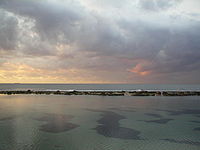
Fishing
Plankton
Plankton are any drifting organisms that inhabit the pelagic zone of oceans, seas, or bodies of fresh water. That is, plankton are defined by their ecological niche rather than phylogenetic or taxonomic classification...
needed to sustain fishing waters. In 1977, Libya's fishing catch was 4,803 tons and 6,418 tons by 1981. Most fleets were located on the western coast near Tripoli. In 1979, fishing boats were estimated at 325, 13 being commercial trawlers; the rest small and medium-sized boats. There were approximately 1,000-1,200 professional fishermen by 1981. The government has encouraged fishing and attempted to stimulate demand. In 1986 a fishing port was constructed at Zuwara, and ice plants were built at several coastal sites. Agreements for joint fishing development were signed with several countries, including Tunisia
Tunisia
Tunisia , officially the Tunisian RepublicThe long name of Tunisia in other languages used in the country is: , is the northernmost country in Africa. It is a Maghreb country and is bordered by Algeria to the west, Libya to the southeast, and the Mediterranean Sea to the north and east. Its area...
and Spain
Spain
Spain , officially the Kingdom of Spain languages]] under the European Charter for Regional or Minority Languages. In each of these, Spain's official name is as follows:;;;;;;), is a country and member state of the European Union located in southwestern Europe on the Iberian Peninsula...
.
Sponge fishing was monopolized by Greek
Greece
Greece , officially the Hellenic Republic , and historically Hellas or the Republic of Greece in English, is a country in southeastern Europe....
fishers. A tiny percentage of the harvest was obtained by Libyans using small boats and skin-diving equipment from shallow waters inshore. In 1977, the government established freshwater fish farms in several inshore locations. In 1997, the low annual catch of 34,500 mt demonstrates Libya’s still underdeveloped fisheries. Low investments in fishing boats, ports, and processing facilities are major obstacles to growth. The country has one major fishing port (Zliten
Zliten
Zliten is a town in the Misrata District of Libya. It is located on the southern coast of the Mediterranean Sea west of the Gulf of Sidra. It was the capital of the former Zlitan District.-Location:...
), one tuna
Tuna
Tuna is a salt water fish from the family Scombridae, mostly in the genus Thunnus. Tuna are fast swimmers, and some species are capable of speeds of . Unlike most fish, which have white flesh, the muscle tissue of tuna ranges from pink to dark red. The red coloration derives from myoglobin, an...
plant and two sardine
Sardine
Sardines, or pilchards, are several types of small, oily fish related to herrings, family Clupeidae. Sardines are named after the Mediterranean island of Sardinia, around which they were once abundant....
factories with small processing capacities (1,000 metric tons per year each). Libya is planning to build 24 fishing ports in addition to one under construction at Marsa Zuaga. With a primary and secondary productive employment base of around 12,000 persons by 2006, the national fisheries sector provides a small fraction - around 1% - of the total labor force. Its estimated contribution to Agricultural GDP is negligible, standing at around 10%.
Forestry
Libya lacks forests for commercial purposes. Although the government designated over 624 km² as woodlandWoodland
Ecologically, a woodland is a low-density forest forming open habitats with plenty of sunlight and limited shade. Woodlands may support an understory of shrubs and herbaceous plants including grasses. Woodland may form a transition to shrubland under drier conditions or during early stages of...
or forest, this land is covered in scrub and minor vegetation. During the 1960s the government began an afforestation
Afforestation
Afforestation is the establishment of a forest or stand of trees in an area where there was no forest. Reforestation is the reestablishment of forest cover, either naturally or artificially...
program. An estimated 213 million seedlings were planted by 1977, 33 million being fruit trees. Most reforestation occurred in western Libya. During reforestation, scientist experimented with a petrochemical
Petrochemical
Petrochemicals are chemical products derived from petroleum. Some chemical compounds made from petroleum are also obtained from other fossil fuels, such as coal or natural gas, or renewable sources such as corn or sugar cane....
spray that is sufficiently porous to allow rain to seep through, yet sturdy enough to prevent seedlings from being blown away during sandstorms. Planting program goals included growing enough trees to meet domestic lumber
Lumber
Lumber or timber is wood in any of its stages from felling through readiness for use as structural material for construction, or wood pulp for paper production....
needs, soil conservation
Soil conservation
Soil conservation is a set of management strategies for prevention of soil being eroded from the Earth’s surface or becoming chemically altered by overuse, acidification, salinization or other chemical soil contamination...
and reclamation
Land reclamation
Land reclamation, usually known as reclamation, is the process to create new land from sea or riverbeds. The land reclaimed is known as reclamation ground or landfill.- Habitation :...
, and windbreaks for crops and settlements.
Statistics
- Area:
- total: 1,759,540 km²
- land: 1,759,540 km²
- water: 0 km²
- Coastline: 1,770 km
- Maritime claims:
- territorial sea: 12 nm
- note: Gulf of SidraGulf of SidraGulf of Sidra is a body of water in the Mediterranean Sea on the northern coast of Libya; it is also known as Gulf of Sirte or the Great Sirte or Greater Syrtis .- Geography :The Gulf of Sidra has been a major centre for tuna fishing in the Mediterranean for centuries...
closing line - 32 degrees, 30 minutes north - exclusive fishing zone: 62 nautical miles (115 km)
- Climate: Mediterranean along coast; dry, extreme desert interior
- Elevation extremes:
- lowest point: Sabkhat Ghuzayyil -47 m
- highest point: Bikku BittiBikku BittiBikku Bitti, also known as Bette Peak, is the highest mountain in Libya at .It is located on the Dohone spur of the Tibesti Mountains in southern Libya, very near the Chad / Libya border....
2,267 m
- Land use:
- arable land: 1.03%
- permanent crops: 0.19%
- other: 98.78% (2005)
- Irrigated land: 4,700 km² (2003)
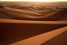
- Geography: more than 90% of the country is desert or semidesert
- Agriculture - products: wheat, barley, olives, dates, citrus, vegetables, peanuts, soybeans; cattle