

Mae Sai
Encyclopedia
Mae Sai is the northernmost district (amphoe
) of Chiang Rai Province
in northern Thailand
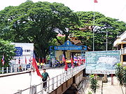
. The town of Mae Sai is a major border crossing between Thailand and Burma. Asian Highway Network
AH2
(Thailand Route 1 or Phahonyothin Road) crosses the Mae Sai River
to the town Tachileik
in Burma.
One-day passes for non-Burmese nationals crossing into Burma are issued at Burma customs in Tachileik. Passports are confiscated and a temporary travel permit is issued; the permit is exchanged for the traveler's passport upon crossing back into Thailand.
 Neighboring districts are (from the east clockwise) Chiang Saen
, Mae Chan
and Mae Fa Luang
. To the north is Myanmar, separated by the Mae Sai River
and the Ruak River
. The westernmost part of the district contains several hills, the most important one is the Doi Tung with the Wat Phra That Doi Tung temple on top.
 The district is subdivided into 8 subdistricts (tambon
), which in turn are further subdivided into 92 villages (muban
). There are two subdistrict municipalities (thesaban tambon) within the district - Mai Sai itself covering parts of the tambon Mae Sai and Wiang Phang Kham, and Huai Khrai covering parts of the tambon Huai Khrai. There are further 8 Tambon administrative organizations (TAO).
The geocode 7 is not used.
Amphoe
An amphoe is the second level administrative subdivision of Thailand. Usually translated as district, amphoe make up the provinces, and are analogous to a county seat...
) of Chiang Rai Province
Chiang Rai Province
Chiang Rai is the northernmost province of Thailand. Neighbouring provinces are Phayao, Lampang and Chiang Mai. In the north it borders Shan State of Myanmar and Bokeo of Laos.-Geography:...
in northern Thailand
Thailand
Thailand , officially the Kingdom of Thailand , formerly known as Siam , is a country located at the centre of the Indochina peninsula and Southeast Asia. It is bordered to the north by Burma and Laos, to the east by Laos and Cambodia, to the south by the Gulf of Thailand and Malaysia, and to the...
. The town of Mae Sai is a major border crossing between Thailand and Burma. Asian Highway Network
Asian Highway Network
The Asian Highway project, also known as the Great Asian Highway, is a cooperative project among countries in Asia and Europe and the United Nations Economic and Social Commission for Asia and the Pacific , to improve the highway systems in Asia...
AH2
AH2
The AH2 is a road in the Asian Highway Network running 8230 miles from Denpasar, Indonesia to Khosravi, Iran. The route is as follows:-Indonesia:Denpasar — Surabaya — Surakarta — Semarang — Cikampek — Jakarta...
(Thailand Route 1 or Phahonyothin Road) crosses the Mae Sai River
Mae Sai River
Mae Sai River is a river that is the natural border between Thailand and Myanmar. It passes under Phahonyothin Road.Upstream of the Mae Sai River was located at Myanmar....
to the town Tachileik
Tachileik
Tachileik , is a border town in the Shan State of eastern Burma . It is the administrative seat of Tachileik Township and Tachileik District.-History:...
in Burma.
One-day passes for non-Burmese nationals crossing into Burma are issued at Burma customs in Tachileik. Passports are confiscated and a temporary travel permit is issued; the permit is exchanged for the traveler's passport upon crossing back into Thailand.
Geography
Amphoe Chiang Saen
Chiang Saen is a district in the northern part of Chiang Rai Province, northern Thailand.-History:According to an ancient chronicle, the original city of Chiang Saen was built in 545 in an area called Yonok, by Tai migrants from the Chinese province of Yunnan, and was an important city of the...
, Mae Chan
Amphoe Mae Chan
Mae Chan is a district in the northern part of Chiang Rai Province, northern Thailand.-Geography:Neighboring districts are Mae Sai, Chiang Saen, Doi Luang, Mueang Chiang Rai and Mae Fa Luang of Chiang Rai Province....
and Mae Fa Luang
Amphoe Mae Fa Luang
Mae Fa Luang is a district in the northern part of Chiang Rai Province, northern Thailand.-History:The area of Mae Fa Luang was separated from Mae Chan district and created as a minor district on April 1, 1992. Originally it comprised the three tambon Thoet Thai, Mae Salong Nai and Mae Salong Nok...
. To the north is Myanmar, separated by the Mae Sai River
Mae Sai River
Mae Sai River is a river that is the natural border between Thailand and Myanmar. It passes under Phahonyothin Road.Upstream of the Mae Sai River was located at Myanmar....
and the Ruak River
Ruak River
The Ruak River is a river at the Thai-Burma border. It originates within the hills of the Shan State , and becomes the boundary river between Thailand and Burma at the confluence with the Mae Sai River at the northernmost point of Thailand. It then meanders to the east until it empties into the...
. The westernmost part of the district contains several hills, the most important one is the Doi Tung with the Wat Phra That Doi Tung temple on top.
History
The minor district (King Amphoe) Mae Sai was created on March 1 1939, when the two tambon Mae Sai and Pong Pha were split off from Chiang Saen district. The area was upgraded to a full district on May 1 1950.Administration
Tambon
Tambon is a local government unit in Thailand. Below district and province , they form the third administrative subdivision level. As of the 2009 there are 7255 tambon, not including the 169 khwaeng of Bangkok, which are set at the same administrative level, thus every district contains 8-10 tambon...
), which in turn are further subdivided into 92 villages (muban
Muban
Muban is the lowest administrative subdivision of Thailand. Usually translated as village, they are the subdivision of tambon. As of 2008, there are 74944 administrative villages in Thailand. As of the 1990 census, the average village consisted of 144 households or 746 persons.A muban does not...
). There are two subdistrict municipalities (thesaban tambon) within the district - Mai Sai itself covering parts of the tambon Mae Sai and Wiang Phang Kham, and Huai Khrai covering parts of the tambon Huai Khrai. There are further 8 Tambon administrative organizations (TAO).
| No. | Name | Thai name | Villages | Inh. Population A population is all the organisms that both belong to the same group or species and live in the same geographical area. The area that is used to define a sexual population is such that inter-breeding is possible between any pair within the area and more probable than cross-breeding with individuals... |
|
|---|---|---|---|---|---|
| 1. | Mae Sai Mae Sai Mae Sai is the northernmost district of Chiang Rai Province in northern Thailand. The town of Mae Sai is a major border crossing between Thailand and Burma... |
แม่สาย | 14 | 21,697 | |
| 2. | Huai Khrai Huai Khrai Huai Khrai is a village and tambon of Mae Sai District, in Chiang Rai Province, Thailand. In 2005 it had a total population of 7,609 people. The tambon contains 11 villages.-References:... |
ห้วยไคร้ | 11 | 7,609 | |
| 3. | Ko Chang Ko Chang, Mae Sai Ko Chang, Mae Sai is a village and tambon of Mae Sai District, in Chiang Rai Province, Thailand. In 2005 it had a total population of 9964 people. The tambon contains 13 villages.-References:... |
เกาะช้าง | 13 | 9,964 | |
| 4. | Pong Pha Pong Pha Pong Pha is a village and tambon of Mae Sai District, in Chiang Rai Province, Thailand. In 2005 it had a total population of 8348 people. The tambon contains 12 villages.... |
โป่งผา | 12 | 8,348 | |
| 5. | Si Mueang Chum Si Mueang Chum Si Mueang Chum is a village and tambon of Mae Sai District, in Chiang Rai Province, Thailand. In 2005 it had a total population of 5,090 people. The tambon contains 9 villages.... |
ศรีเมืองชุม | 9 | 5,090 | |
| 6. | Wiang Phang Kham Wiang Phang Kham Wiang Phang Kham is a village and tambon of Mae Sai District, in Chiang Rai Province, Thailand. In 2005 it had a total population of 19,945 people. The tambon contains 13 villages.... |
เวียงพางคำ | 13 | 19,945 | |
| 8. | Ban Dai Ban Dai Ban Dai is a village and tambon of Mae Sai District, in Chiang Rai Province, Thailand. In 2005 it had a total population of 4117 people. The tambon contains 8 villages.... |
บ้านด้าย | 8 | 4,117 | |
| 9. | Pong Ngam Pong Ngam Pong Ngam is a village and tambon of Mae Sai District, in Chiang Rai Province, Thailand. In 2005 it had a total population of 9,528 people. The tambon contains 12 villages.... |
โป่งงาม | 12 | 9,528 |
The geocode 7 is not used.
External links
- amphoe.com (Thai)
- http://www.maesai.go.th Website of Mae Sai township (Thai)