
2008 North Indian Ocean cyclone season
Encyclopedia
The 2008 North Indian cyclone season was an ongoing event in the annual cycle of tropical cyclone
formation. The North Indian cyclone season has no official bounds, but cyclones tend to form between April and December, with peaks in May and November. These dates conventionally delimit the period of each year when most tropical cyclones form in the northern Indian Ocean
.
The scope of this basin is north of the Equator and west of the Malaysian Peninsula. The India Meteorological Department
(IMD) and Joint Typhoon Warning Center
(JTWC) monitor tropical cyclones in this basin. This basin is divided into two different seas by India
; the Arabian Sea
to the west, abbreviated ARB by the IMD, and the Bay of Bengal
to the east, abbreviated BOB by the IMD. On average, about 4 to 6 storms form in this basin every season.
The 2008 North Indian Ocean season was average in activity, but was very eventful. This season ranks as the costliest and one of the deadliest seasons on record, with about 12 billion dollars in damage and over 138,000 deaths. Cyclone Nargis was the most notable storm of the season. It caused the worst natural disaster in Myanmar's history, and caused the majority of the damages and deaths this year.
on April 24. It slowly started moving in a northwesterly direction into an area of low vertical wind shear. The JTWC
started issuing statements on the system on April 25. On April 27, the Indian Meteorological Department upgraded it to a depression, and the next day it was upgraded to Cyclonic Storm Nargis. A few hours later it was upgraded to a Severe Cyclonic Storm. The next day it was given the status of a Very Severe Cyclonic Storm with winds up to 90 knots (based on IMD
observations) although the JTWC
observed peak winds of 115 knots, or 135 mph (215 km/h). Nargis hit southern Burma with 135 mph winds winds and then gradually started dissipating.
Damage in Myanmar was extensive, where 243 people have been reported dead according to United Nations
officials. Later, there were nearly 4,000 deaths confirmed. It became likely that 15,000 or even 22,000 deaths occurred, but this was disputed by officials. Later, 22,980 deaths have been blamed on Nargis and more than 40,000 other people were missing. If they were all killed, then Nargis would be the 6th deadliest cyclone in this basin on record, and the 3rd deadliest in this basin in modern history. The Labutta Township
alone reportedly had a toll of 80,000 deaths; 10,000 more were in Bogale, and some estimate the death toll from Nargis being well over 100,000, and is at least as of now around 138,000. So far, Nargis is ranked as the 7th deadliest cyclone of all time and the second deadliest named cyclone of all time, after Typhoon Nina
of 1975
. Thousands of homes and businesses throughout the country, including in Yangon
, were damaged or destroyed by the winds and storm surge. The Irrawaddy Delta
also suffered severely from the storm surge.The most affected areas map released by ReliefWeb
.
The final toll from Nargis is at least 138,000 people killed in in Myanmar, and about $10 billion dollars in damage (USD
).
.
. Over the next 24 hours deep convection developed around the low pressure area and thus it was upgraded to Depression BOB 02 early the next day, as it was located about 220 km, (135 miles), southeast of Kolkata
, near to the Bangladesh
coastline. However it as the depression was located within an area of mid to high vertical wind shear it did not develop further. Later that morning before the depression made landfall it reached its peak pressure of 988 hPa
/mbar. The depression then made landfall on the Bangladesh coast and slowly weakened into an area of low pressure, whilst located over Jharkhand
in India
. There was heavy rainfall reported in Orissa
, West Bengal
and Jharkhand
parts of India
. At least four people were killed by the depression. Five other people were reported as missing after a bridge they were driving over collapsed.
, India. Early the next day, the depression made landfall on the Orissa coast. IMD did not upgrade it until it was overland near Puri. Consequently, it was designated as a land depression in the end of monsoon season report. Later in the day, the IMD issued its final advisory on the depression as it weakened into a low pressure area.
The Deep Depression caused 10 deaths in the state of Orissa
.
The Depression also caused 15 deaths in Uttar Pradesh
, its state capital Lucknow
received the heaviest rains for September in the last 10 years.
Over 100 fishermen were reported missing as 25 trawlers capsized in the Bay of Bengal off Bangladesh's southern coastal areas as the sea turned rough due to a depression. The Deep Depression also caused storm surge up to 15 to 20 feet high.
Overall, the storm killed at least 25 people in India (10 in Orissa, 15 in Uttar Pradesh), but overall damage was minor.
, Oman
had intensified in to a tropical depression and was assigned the number ARB 02. On October 21 IMD updated the system to a Deep Depression while it lay 700 km south of Salalah
, Oman
near the east coast of Somalia
. It lost its strength while crossing the Gulf of Aden due to entry of dry air and land interaction as it passed close to the northeastern coast of Somalia. It later was downgraded to a Depression, named TC 03B by the JTWC.
On October 24 it made landfall on the south-eastern coast of Yemen
, leaving at least 26 civilians and six soldiers dead while trapping hundreds of people due to flooding and torrential rainfalls. The latest figure of casualties is of 180 persons dead and 100 others missing, mostly from the region of Hadhramawt, where the storm made landfall. 733 houses were destroyed in the governorates of Hadhramawt
and Al-Mahrah
, while 22,000 people were displaced. The Yemeni Government declared the two aforementioned governorates as disaster zones
. The most affected areas map released by ReliefWeb
.
Overall, this weak storm killed at least 180 people in Yemen. Damage is estimated at about $1 billion (USD
).
coast based on satellite, coastal observations, and buoy data intensified into a depression. The depression remained practically stationary and intensified into a deep depression and lay centred as of 0530 hours IST today, the 26th of October 2008, about 400 km east-northeast of Visakhapatnam
, 250 km south-southeast of Paradip
and 550 km south-southwest of Kolkata
. The Joint Typhoon Warning Center began issuing advisories on the system a few hours later that early morning, designating it as Tropical Cyclone 04B. The IMD named it cyclonic storm Rashmi.The observed track of Deep Depression making inland into Uttar Pradesh after crossing Orissa The track of cyclonic storm Rashmi making landfall in Bangladesh
The Cyclone crossed the Khulna
-Barisal coast at Patharghata
, Bangladesh
on 27 October 2008, with winds of 80 km/hour. 15 people were killed and thousands of homes were also damaged. Rashmi brought down electrical and telephone poles and uprooted trees, large areas of acres of crops were also destroyed. 5 people were also killed in the state of Meghalaya
, India
. At least 50 fishermen were reported missing when about 15 fishing trawlers capsized offshore.
Rashmi killed at least 28 people. 15 people were killed in Bangladesh and 13 people were killed in India (5 in Meghalaya,
8 in Arunachal Pradesh).
and Kakinada
near Machilipatnam
. However, the system became sheared to the western periphery and the IMD downgraded it back into a deep depression.
Khai-Muk headed northwest and then northwards after making landfall in Andhra Pradesh
. The name Khai-Muk was contributed by Thailand
, it means pearl
in Thai
.
By November 15, all ports in Andhra Pradesh
were under cautionary signal number three. All fishermen were advised to remain at port due to rough seas. Residents along the shore were urged to evacuate as waves up to 2 m (6.5 ft) were forecast to impact the coast.
High winds knocked down trees and power lines causing traffic jams throughout the Andhra Pradesh. Boats and fishing nets were washed away by high waves produced by Khai-muk, costing Rs. 2 cores ($430,000 USD). An average of 53.5 mm (2.1 in) of rain fell throughout the state. The highest rainfall was recorded in Bantumilli
at 172 mm (6.7 in). An estimated 1.2 million hectares of crops were damaged or destroyed by the storm leading to Rs. 10 cores ($1.9 million USD) in agricultural losses. A total of 148 homes were destroyed and another 23 were damaged, amounting to Rs. 4 crores ($780,000 USD) in monetary losses. A 5 km (3.1 mi) stretch of highway was washed out by the storm and damages to the road amounted to Rs. 4 crores ($780,000 USD).
A state of high alert was declared in Andhra Pradesh following the storm in the state. About 7,500 people were evacuated from several towns to 23 shelters set up by officials. The shelters provided the residents with breakfast and milk on November 16. The following day, a total of 44,949 people had evacuated to 66 relief shelters. The minister of Andhra requested that the government send rice, pulses, oil and other materials to cyclone victims.
and coastal stations of Tamil Nadu, indicated that a depression had formed over Sri Lanka in southwest Bay of Bengal. The depression remained nearly stationary and intensified into a deep depression three hours later. The IMD posted a cyclone watch for Tamil Nadu region of India noting that the system was likely to intensify into a cyclonic storm and cross Tamil Nadu coast between Pamban and Nagapattinam by tomorrow night. Very late in the day the IMD mentioned that the deep depression would intensify, however the cyclone watch for Tamil Nadu coast was lowered (or not mentioned) in the bulletin issued. Early on November 26, the deep depression close to Tamil Nadu coast intensified into a cyclonic storm and was named "Nisha". It crossed the coast close to the north of Karaikal
between 0530 and 0630 hours IST on November 27. On November 28, JTWC issued their final warning. Nisha headed northwest towards south Karnataka after making landfall in Tamilnadu.
15 people have been killed when Nisha hit northern Sri Lanka on November 25, 2008, causing heavy rains and flooding that reportedly displaced between 60,000 and 70,000 people in Vanni
and 20,000 people in Jaffna
district. Jaffna recorded the highest rainfall since 1918, of 520.1 mm of rain in last week, with Wednesday’s reading of 389.8 mm, being the highest in nine decades.
189 people have been killed by the heavy rains and floods caused by the Nisha in Tamil Nadu
and the death toll is expected to rise. Some places have recorded extreme rainfall, notably Orathanadu, Thanjavur District where over 660 mm of rain fell within a period of 24 hours and broke the 65-year old record of highest rainfall registered in 24 hours in Tamil Nadu. In two days, Orathanadu registered 990 mm of rainfall. Previously the highest amount of rainfall in a day was 570 mm registered by Cuddalore
on May 18, 1943
. The most affected areas map released by ReliefWeb
.
Nisha killed 204 people making it the 4th deadliest storm in 2008 after Cyclone Nargis
, Typhoon Fengshen
and Hurricane Hanna. Damage is estimated at about 3789 crores i.e. $800 million (USD
).
within the Intertropical Convergence Zone
. The system was well organized with good convection present from the previous 48 hours. On December 4, the India Meteorological Department
(IMD) upgraded the area of low pressure to a depression giving it the designation "BOB 08". At that time it was located approximately 650 kilometres (403.9 mi) south-southwest of Port Blair
. That day, the Joint Typhoon Warning Center
(JTWC) designated the system as Tropical Cyclone 07B. Early on December 5, the IMD upgraded Depression BOB 08 to a deep depression. On December 7, the IMD reported that BOB 08 weakened into a depression. The depression continued to weaken until it decayed into a remnant low late on the same day.
Tropical cyclone
A tropical cyclone is a storm system characterized by a large low-pressure center and numerous thunderstorms that produce strong winds and heavy rain. Tropical cyclones strengthen when water evaporated from the ocean is released as the saturated air rises, resulting in condensation of water vapor...
formation. The North Indian cyclone season has no official bounds, but cyclones tend to form between April and December, with peaks in May and November. These dates conventionally delimit the period of each year when most tropical cyclones form in the northern Indian Ocean
Indian Ocean
The Indian Ocean is the third largest of the world's oceanic divisions, covering approximately 20% of the water on the Earth's surface. It is bounded on the north by the Indian Subcontinent and Arabian Peninsula ; on the west by eastern Africa; on the east by Indochina, the Sunda Islands, and...
.
The scope of this basin is north of the Equator and west of the Malaysian Peninsula. The India Meteorological Department
India Meteorological Department
The India Meteorological Department , also referred to as the Met Office, is an agency of the Ministry of Earth Sciences of the Government of India. It is the principal agency responsible for meteorological observations, weather forecasting and seismology...
(IMD) and Joint Typhoon Warning Center
Joint Typhoon Warning Center
The Joint Typhoon Warning Center is a joint United States Navy – United States Air Force task force located at the Naval Maritime Forecast Center in Pearl Harbor, Hawaii...
(JTWC) monitor tropical cyclones in this basin. This basin is divided into two different seas by India
India
India , officially the Republic of India , is a country in South Asia. It is the seventh-largest country by geographical area, the second-most populous country with over 1.2 billion people, and the most populous democracy in the world...
; the Arabian Sea
Arabian Sea
The Arabian Sea is a region of the Indian Ocean bounded on the east by India, on the north by Pakistan and Iran, on the west by the Arabian Peninsula, on the south, approximately, by a line between Cape Guardafui in northeastern Somalia and Kanyakumari in India...
to the west, abbreviated ARB by the IMD, and the Bay of Bengal
Bay of Bengal
The Bay of Bengal , the largest bay in the world, forms the northeastern part of the Indian Ocean. It resembles a triangle in shape, and is bordered mostly by the Eastern Coast of India, southern coast of Bangladesh and Sri Lanka to the west and Burma and the Andaman and Nicobar Islands to the...
to the east, abbreviated BOB by the IMD. On average, about 4 to 6 storms form in this basin every season.
The 2008 North Indian Ocean season was average in activity, but was very eventful. This season ranks as the costliest and one of the deadliest seasons on record, with about 12 billion dollars in damage and over 138,000 deaths. Cyclone Nargis was the most notable storm of the season. It caused the worst natural disaster in Myanmar's history, and caused the majority of the damages and deaths this year.
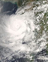
Very Severe Cyclonic Storm Nargis
An area of disturbed weather formed east of the Nicobar IslandsNicobar Islands
The Nicobar Islands are an archipelagic island chain in the eastern Indian Ocean...
on April 24. It slowly started moving in a northwesterly direction into an area of low vertical wind shear. The JTWC
Joint Typhoon Warning Center
The Joint Typhoon Warning Center is a joint United States Navy – United States Air Force task force located at the Naval Maritime Forecast Center in Pearl Harbor, Hawaii...
started issuing statements on the system on April 25. On April 27, the Indian Meteorological Department upgraded it to a depression, and the next day it was upgraded to Cyclonic Storm Nargis. A few hours later it was upgraded to a Severe Cyclonic Storm. The next day it was given the status of a Very Severe Cyclonic Storm with winds up to 90 knots (based on IMD
India Meteorological Department
The India Meteorological Department , also referred to as the Met Office, is an agency of the Ministry of Earth Sciences of the Government of India. It is the principal agency responsible for meteorological observations, weather forecasting and seismology...
observations) although the JTWC
Joint Typhoon Warning Center
The Joint Typhoon Warning Center is a joint United States Navy – United States Air Force task force located at the Naval Maritime Forecast Center in Pearl Harbor, Hawaii...
observed peak winds of 115 knots, or 135 mph (215 km/h). Nargis hit southern Burma with 135 mph winds winds and then gradually started dissipating.
Damage in Myanmar was extensive, where 243 people have been reported dead according to United Nations
United Nations
The United Nations is an international organization whose stated aims are facilitating cooperation in international law, international security, economic development, social progress, human rights, and achievement of world peace...
officials. Later, there were nearly 4,000 deaths confirmed. It became likely that 15,000 or even 22,000 deaths occurred, but this was disputed by officials. Later, 22,980 deaths have been blamed on Nargis and more than 40,000 other people were missing. If they were all killed, then Nargis would be the 6th deadliest cyclone in this basin on record, and the 3rd deadliest in this basin in modern history. The Labutta Township
Labutta Township
Labutta Township or Latputta Township is one of the two township in Labutta District in the Ayeyarwady Region of Burma . It is located in the delta of the Irrawaddy....
alone reportedly had a toll of 80,000 deaths; 10,000 more were in Bogale, and some estimate the death toll from Nargis being well over 100,000, and is at least as of now around 138,000. So far, Nargis is ranked as the 7th deadliest cyclone of all time and the second deadliest named cyclone of all time, after Typhoon Nina
Typhoon Nina (1975)
Super Typhoon Nina was a short-lived but intense super typhoon that caused catastrophic damage and loss of life in China after causing the Banqiao Dam to collapse...
of 1975
1975 Pacific typhoon season
The 1975 Pacific typhoon season has no official bounds; it ran year-round in 1975, but most tropical cyclones tend to form in the northwestern Pacific Ocean between June and December...
. Thousands of homes and businesses throughout the country, including in Yangon
Yangon
Yangon is a former capital of Burma and the capital of Yangon Region . Although the military government has officially relocated the capital to Naypyidaw since March 2006, Yangon, with a population of over four million, continues to be the country's largest city and the most important commercial...
, were damaged or destroyed by the winds and storm surge. The Irrawaddy Delta
Irrawaddy Delta
The Irrawaddy Delta or Ayeyarwady Delta lies in the Ayeyarwady Region , the lowest expanse of land in Burma that fans out from the limit of tidal influence at Myan Aung to the Bay of Bengal and Andaman Sea, 290 km to the south at the mouth of the Ayeyarwady River...
also suffered severely from the storm surge.The most affected areas map released by ReliefWeb
ReliefWeb
ReliefWeb is an on-line gateway to information on humanitarian emergencies and disasters. An independent vehicle of information, designed specifically to assist the international humanitarian community in effective delivery of emergency assistance, it provides information as events unfold, while...
.
The final toll from Nargis is at least 138,000 people killed in in Myanmar, and about $10 billion dollars in damage (USD
United States dollar
The United States dollar , also referred to as the American dollar, is the official currency of the United States of America. It is divided into 100 smaller units called cents or pennies....
).
Depression ARB 01
An area of convection formed north west of India on June 4. Early the next day the IMD designated it as Depression ARB 01. Although it was forecast to intensify further, it did not develop as it turned away from the coast. The IMD downgraded it to an active area of low pressure on June 7 as it weakened over the Arabian SeaArabian Sea
The Arabian Sea is a region of the Indian Ocean bounded on the east by India, on the north by Pakistan and Iran, on the west by the Arabian Peninsula, on the south, approximately, by a line between Cape Guardafui in northeastern Somalia and Kanyakumari in India...
.
Depression BOB 02
Early on June 15, an area of low pressure formed within the monsoonal trough over the northern part of the Bay of BengalBay of Bengal
The Bay of Bengal , the largest bay in the world, forms the northeastern part of the Indian Ocean. It resembles a triangle in shape, and is bordered mostly by the Eastern Coast of India, southern coast of Bangladesh and Sri Lanka to the west and Burma and the Andaman and Nicobar Islands to the...
. Over the next 24 hours deep convection developed around the low pressure area and thus it was upgraded to Depression BOB 02 early the next day, as it was located about 220 km, (135 miles), southeast of Kolkata
Kolkata
Kolkata , formerly known as Calcutta, is the capital of the Indian state of West Bengal. Located on the east bank of the Hooghly River, it was the commercial capital of East India...
, near to the Bangladesh
Bangladesh
Bangladesh , officially the People's Republic of Bangladesh is a sovereign state located in South Asia. It is bordered by India on all sides except for a small border with Burma to the far southeast and by the Bay of Bengal to the south...
coastline. However it as the depression was located within an area of mid to high vertical wind shear it did not develop further. Later that morning before the depression made landfall it reached its peak pressure of 988 hPa
HPA
-Organizations:*Halifax Port Authority, a port authority in Canada*Hamburg Port Authority, the port authority for the Port of Hamburg, Germany*Health Protection Agency, a health organization in the United Kingdom...
/mbar. The depression then made landfall on the Bangladesh coast and slowly weakened into an area of low pressure, whilst located over Jharkhand
Jharkhand
Jharkhand is a state in eastern India. It was carved out of the southern part of Bihar on 15 November 2000. Jharkhand shares its border with the states of Bihar to the north, Uttar Pradesh and Chhattisgarh to the west, Orissa to the south, and West Bengal to the east...
in India
India
India , officially the Republic of India , is a country in South Asia. It is the seventh-largest country by geographical area, the second-most populous country with over 1.2 billion people, and the most populous democracy in the world...
. There was heavy rainfall reported in Orissa
Orissa
Orissa , officially Odisha since Nov 2011, is a state of India, located on the east coast of India, by the Bay of Bengal. It is the modern name of the ancient nation of Kalinga, which was invaded by the Maurya Emperor Ashoka in 261 BC. The modern state of Orissa was established on 1 April...
, West Bengal
West Bengal
West Bengal is a state in the eastern region of India and is the nation's fourth-most populous. It is also the seventh-most populous sub-national entity in the world, with over 91 million inhabitants. A major agricultural producer, West Bengal is the sixth-largest contributor to India's GDP...
and Jharkhand
Jharkhand
Jharkhand is a state in eastern India. It was carved out of the southern part of Bihar on 15 November 2000. Jharkhand shares its border with the states of Bihar to the north, Uttar Pradesh and Chhattisgarh to the west, Orissa to the south, and West Bengal to the east...
parts of India
India
India , officially the Republic of India , is a country in South Asia. It is the seventh-largest country by geographical area, the second-most populous country with over 1.2 billion people, and the most populous democracy in the world...
. At least four people were killed by the depression. Five other people were reported as missing after a bridge they were driving over collapsed.
Depression BOB 03
On August 9, a tropical depression formed in the North Indian Ocean, south of OrissaOrissa
Orissa , officially Odisha since Nov 2011, is a state of India, located on the east coast of India, by the Bay of Bengal. It is the modern name of the ancient nation of Kalinga, which was invaded by the Maurya Emperor Ashoka in 261 BC. The modern state of Orissa was established on 1 April...
, India. Early the next day, the depression made landfall on the Orissa coast. IMD did not upgrade it until it was overland near Puri. Consequently, it was designated as a land depression in the end of monsoon season report. Later in the day, the IMD issued its final advisory on the depression as it weakened into a low pressure area.
Deep Depression BOB 04
On September 14 an area of low pressure formed south east of Kolkata India. During September 15 the IMD designated this area of low pressure as Depression BOB 04. Later that day the JTWC issued a Tropical Cyclone Formation Alert on the tropical depression. During the morning of September 15 the depression intensified into a Deep Depression as it moved closer to the Orissa Coast. Later that day the JTWC issued their first advisory on this system designating it as Tropical Cyclone 02B The Depression then made landfall on the Orissa coast later that day. So the JTWC issued their last advisory on the depression later that day. However the IMD kept issuing advisories on the Deep Depression. The RSMC then downgraded it to a depression on September 18 as it moved further inland. The RSMC issued their final advisory the next day as the depression had weakened in to a well marked low pressure area. The track of Deep Depression making inland into Uttar Pradesh after crossing OrissaThe Deep Depression caused 10 deaths in the state of Orissa
Orissa
Orissa , officially Odisha since Nov 2011, is a state of India, located on the east coast of India, by the Bay of Bengal. It is the modern name of the ancient nation of Kalinga, which was invaded by the Maurya Emperor Ashoka in 261 BC. The modern state of Orissa was established on 1 April...
.
The Depression also caused 15 deaths in Uttar Pradesh
Uttar Pradesh
Uttar Pradesh abbreviation U.P. , is a state located in the northern part of India. With a population of over 200 million people, it is India's most populous state, as well as the world's most populous sub-national entity...
, its state capital Lucknow
Lucknow
Lucknow is the capital city of Uttar Pradesh in India. Lucknow is the administrative headquarters of Lucknow District and Lucknow Division....
received the heaviest rains for September in the last 10 years.
Over 100 fishermen were reported missing as 25 trawlers capsized in the Bay of Bengal off Bangladesh's southern coastal areas as the sea turned rough due to a depression. The Deep Depression also caused storm surge up to 15 to 20 feet high.
Overall, the storm killed at least 25 people in India (10 in Orissa, 15 in Uttar Pradesh), but overall damage was minor.
Deep Depression ARB 02
On October 19 the IMD noted that an area of low pressure which located to the south east of SalalahSalalah
Salalah , is the capital and seat of the governor or Wali of the southern Omani province of Dhofar. The population of Salalah was 197,169 in 2009....
, Oman
Oman
Oman , officially called the Sultanate of Oman , is an Arab state in southwest Asia on the southeast coast of the Arabian Peninsula. It is bordered by the United Arab Emirates to the northwest, Saudi Arabia to the west, and Yemen to the southwest. The coast is formed by the Arabian Sea on the...
had intensified in to a tropical depression and was assigned the number ARB 02. On October 21 IMD updated the system to a Deep Depression while it lay 700 km south of Salalah
Salalah
Salalah , is the capital and seat of the governor or Wali of the southern Omani province of Dhofar. The population of Salalah was 197,169 in 2009....
, Oman
Oman
Oman , officially called the Sultanate of Oman , is an Arab state in southwest Asia on the southeast coast of the Arabian Peninsula. It is bordered by the United Arab Emirates to the northwest, Saudi Arabia to the west, and Yemen to the southwest. The coast is formed by the Arabian Sea on the...
near the east coast of Somalia
Somalia
Somalia , officially the Somali Republic and formerly known as the Somali Democratic Republic under Socialist rule, is a country located in the Horn of Africa. Since the outbreak of the Somali Civil War in 1991 there has been no central government control over most of the country's territory...
. It lost its strength while crossing the Gulf of Aden due to entry of dry air and land interaction as it passed close to the northeastern coast of Somalia. It later was downgraded to a Depression, named TC 03B by the JTWC.
On October 24 it made landfall on the south-eastern coast of Yemen
Yemen
The Republic of Yemen , commonly known as Yemen , is a country located in the Middle East, occupying the southwestern to southern end of the Arabian Peninsula. It is bordered by Saudi Arabia to the north, the Red Sea to the west, and Oman to the east....
, leaving at least 26 civilians and six soldiers dead while trapping hundreds of people due to flooding and torrential rainfalls. The latest figure of casualties is of 180 persons dead and 100 others missing, mostly from the region of Hadhramawt, where the storm made landfall. 733 houses were destroyed in the governorates of Hadhramawt
Hadhramaut Governorate
Hadhramaut or Hadramawt is a governorate of Yemen. Lying within the large historical region of Hadhramaut, it is the country's largest governorate.-Overview:...
and Al-Mahrah
Al Mahrah Governorate
Al Mahrah or Mahra is a governorate of Yemen in the southern Arabian Peninsula. Situated in the area of the former Mahra Sultanate, its capital is Al Ghaydah....
, while 22,000 people were displaced. The Yemeni Government declared the two aforementioned governorates as disaster zones
Disaster area
A disaster area is a region or a locale heavily damaged by either natural hazards, such as tornadoes, hurricanes, tsunamis, floods, earthquakes, technological hazards including nuclear and radiation accidents, or sociological hazards like riots, terrorism or war. The population living there often...
. The most affected areas map released by ReliefWeb
ReliefWeb
ReliefWeb is an on-line gateway to information on humanitarian emergencies and disasters. An independent vehicle of information, designed specifically to assist the international humanitarian community in effective delivery of emergency assistance, it provides information as events unfold, while...
.
Overall, this weak storm killed at least 180 people in Yemen. Damage is estimated at about $1 billion (USD
United States dollar
The United States dollar , also referred to as the American dollar, is the official currency of the United States of America. It is divided into 100 smaller units called cents or pennies....
).
Cyclonic Storm Rashmi
On October 25, an area of low pressure which was located east of the Andhra PradeshAndhra Pradesh
Andhra Pradesh , is one of the 28 states of India, situated on the southeastern coast of India. It is India's fourth largest state by area and fifth largest by population. Its capital and largest city by population is Hyderabad.The total GDP of Andhra Pradesh is $100 billion and is ranked third...
coast based on satellite, coastal observations, and buoy data intensified into a depression. The depression remained practically stationary and intensified into a deep depression and lay centred as of 0530 hours IST today, the 26th of October 2008, about 400 km east-northeast of Visakhapatnam
Visakhapatnam
Visakhapatnam is a major sea port on the south east coast of India. With a population of approximately 1.7 million, it is the second largest city in the state of Andhra Pradesh and the third largest city on the east coast of India after Kolkata and Chennai. According to the history, the city was...
, 250 km south-southeast of Paradip
Paradip
Paradip, also spelt Paradeep, is a major seaport town and a designated notified area in Jagatsinghpur district of Orissa, India.-Geography:Paradip is located at . It has an average elevation of .-Paradip Port:...
and 550 km south-southwest of Kolkata
Kolkata
Kolkata , formerly known as Calcutta, is the capital of the Indian state of West Bengal. Located on the east bank of the Hooghly River, it was the commercial capital of East India...
. The Joint Typhoon Warning Center began issuing advisories on the system a few hours later that early morning, designating it as Tropical Cyclone 04B. The IMD named it cyclonic storm Rashmi.The observed track of Deep Depression making inland into Uttar Pradesh after crossing Orissa The track of cyclonic storm Rashmi making landfall in Bangladesh
Bangladesh
Bangladesh , officially the People's Republic of Bangladesh is a sovereign state located in South Asia. It is bordered by India on all sides except for a small border with Burma to the far southeast and by the Bay of Bengal to the south...
The Cyclone crossed the Khulna
Khulna
Khulna is the third largest city in Bangladesh. It is located on the banks of the Rupsha and Bhairab rivers in Khulna District. It is the divisional headquarters of Khulna Division and a major industrial and commercial center. It has a seaport named Mongla on its outskirts, 38 km from Khulna...
-Barisal coast at Patharghata
Patharghata
Patharghata is a village in Barguna District in the Barisal Division of southern-central Bangladesh.-References:Patherghata is a Thana in Baruna. Patherghata ia famous for Fish & BFDC & also there natural beauty-External links:*...
, Bangladesh
Bangladesh
Bangladesh , officially the People's Republic of Bangladesh is a sovereign state located in South Asia. It is bordered by India on all sides except for a small border with Burma to the far southeast and by the Bay of Bengal to the south...
on 27 October 2008, with winds of 80 km/hour. 15 people were killed and thousands of homes were also damaged. Rashmi brought down electrical and telephone poles and uprooted trees, large areas of acres of crops were also destroyed. 5 people were also killed in the state of Meghalaya
Meghalaya
Meghalaya is a state in north-eastern India. The word "Meghalaya" literally means the Abode of Clouds in Sanskrit and other Indic languages. Meghalaya is a hilly strip in the eastern part of the country about 300 km long and 100 km wide, with a total area of about 8,700 sq mi . The...
, India
India
India , officially the Republic of India , is a country in South Asia. It is the seventh-largest country by geographical area, the second-most populous country with over 1.2 billion people, and the most populous democracy in the world...
. At least 50 fishermen were reported missing when about 15 fishing trawlers capsized offshore.
Rashmi killed at least 28 people. 15 people were killed in Bangladesh and 13 people were killed in India (5 in Meghalaya,
8 in Arunachal Pradesh).
Cyclonic Storm Khai-Muk
On November 13, a low pressure area identified by the India Meteorological Department over southeast Bay of Bengal and adjoining areas concentrated into a depression east-southeast of Chennai, India. The IMD expects the system to intensify further and move towards north Tamil-Nadu/south Andhra Pradesh coasts. The Joint Typhoon Warning Center issued a tropical cyclone warning on the tropical cyclone early on November 14 naming it as Tropical Cyclone 05B. A few hours later the IMD upgraded the system to a deep depression issuing a Cyclone Watch for Andhra Pradesh as intensification into a cyclonic storm was possible. By mid morning the IMD advised the eastern coast of India that the system was expected to cross Andhra Pradesh by noon the next day (local time). Later that morning the deep depression intensified into a cyclonic storm and was named Khai-Muk and the cyclone watch was raised to a warning for Andhra Pradesh coast with Khai-Muk forecast to intensify even further before it made landfall in the afternoon or evening of November 15 between BapatlaBapatla
Bapatla, formerly known as Bhavapuri, is a town and mandal of Guntur District, Andhra Pradesh, India. It is located south of Guntur City on the East Coast.-Assembly constituency:Bapatla is an assembly constituency in Andhra Pradesh....
and Kakinada
Kakinada
Kakinada is a city and a municipal corporation in the Indian state of Andhra Pradesh. It is located east of the state capital, Hyderabad. It is also the headquarters of East Godavari district. It is nicknamed "Fertilizer City" , "Pensioner's Paradise" and "Second Madras"...
near Machilipatnam
Machilipatnam
Machilipatnam is a city and a special grade municipality in the Krishna district, Andhra Pradesh, India. It is located south east of state capital, Hyderabad.-History:...
. However, the system became sheared to the western periphery and the IMD downgraded it back into a deep depression.
Khai-Muk headed northwest and then northwards after making landfall in Andhra Pradesh
Andhra Pradesh
Andhra Pradesh , is one of the 28 states of India, situated on the southeastern coast of India. It is India's fourth largest state by area and fifth largest by population. Its capital and largest city by population is Hyderabad.The total GDP of Andhra Pradesh is $100 billion and is ranked third...
. The name Khai-Muk was contributed by Thailand
Thailand
Thailand , officially the Kingdom of Thailand , formerly known as Siam , is a country located at the centre of the Indochina peninsula and Southeast Asia. It is bordered to the north by Burma and Laos, to the east by Laos and Cambodia, to the south by the Gulf of Thailand and Malaysia, and to the...
, it means pearl
Pearl
A pearl is a hard object produced within the soft tissue of a living shelled mollusk. Just like the shell of a mollusk, a pearl is made up of calcium carbonate in minute crystalline form, which has been deposited in concentric layers. The ideal pearl is perfectly round and smooth, but many other...
in Thai
Thai language
Thai , also known as Central Thai and Siamese, is the national and official language of Thailand and the native language of the Thai people, Thailand's dominant ethnic group. Thai is a member of the Tai group of the Tai–Kadai language family. Historical linguists have been unable to definitively...
.
By November 15, all ports in Andhra Pradesh
Andhra Pradesh
Andhra Pradesh , is one of the 28 states of India, situated on the southeastern coast of India. It is India's fourth largest state by area and fifth largest by population. Its capital and largest city by population is Hyderabad.The total GDP of Andhra Pradesh is $100 billion and is ranked third...
were under cautionary signal number three. All fishermen were advised to remain at port due to rough seas. Residents along the shore were urged to evacuate as waves up to 2 m (6.5 ft) were forecast to impact the coast.
High winds knocked down trees and power lines causing traffic jams throughout the Andhra Pradesh. Boats and fishing nets were washed away by high waves produced by Khai-muk, costing Rs. 2 cores ($430,000 USD). An average of 53.5 mm (2.1 in) of rain fell throughout the state. The highest rainfall was recorded in Bantumilli
Bantumilli
Bantumilli is a village and mandal in Krishna District, Andhra Pradesh, India.-Geography:Bantumilli is located at . It has an average elevation of 0.5 metres .-Demographics:...
at 172 mm (6.7 in). An estimated 1.2 million hectares of crops were damaged or destroyed by the storm leading to Rs. 10 cores ($1.9 million USD) in agricultural losses. A total of 148 homes were destroyed and another 23 were damaged, amounting to Rs. 4 crores ($780,000 USD) in monetary losses. A 5 km (3.1 mi) stretch of highway was washed out by the storm and damages to the road amounted to Rs. 4 crores ($780,000 USD).
A state of high alert was declared in Andhra Pradesh following the storm in the state. About 7,500 people were evacuated from several towns to 23 shelters set up by officials. The shelters provided the residents with breakfast and milk on November 16. The following day, a total of 44,949 people had evacuated to 66 relief shelters. The minister of Andhra requested that the government send rice, pulses, oil and other materials to cyclone victims.
Cyclonic Storm Nisha
Late in the morning of November 25, India Meteorological Department satellite imageries, including surface observations from Sri LankaSri Lanka
Sri Lanka, officially the Democratic Socialist Republic of Sri Lanka is a country off the southern coast of the Indian subcontinent. Known until 1972 as Ceylon , Sri Lanka is an island surrounded by the Indian Ocean, the Gulf of Mannar and the Palk Strait, and lies in the vicinity of India and the...
and coastal stations of Tamil Nadu, indicated that a depression had formed over Sri Lanka in southwest Bay of Bengal. The depression remained nearly stationary and intensified into a deep depression three hours later. The IMD posted a cyclone watch for Tamil Nadu region of India noting that the system was likely to intensify into a cyclonic storm and cross Tamil Nadu coast between Pamban and Nagapattinam by tomorrow night. Very late in the day the IMD mentioned that the deep depression would intensify, however the cyclone watch for Tamil Nadu coast was lowered (or not mentioned) in the bulletin issued. Early on November 26, the deep depression close to Tamil Nadu coast intensified into a cyclonic storm and was named "Nisha". It crossed the coast close to the north of Karaikal
Karaikal
Karaikal is a major port city of east coast of India and a municipality in Karaikal district in the Union Territory of Pondicherry, India. Several explanations are offered for the word 'Karaikal'. The imperial Gazetteer gives it the meaning 'fish pass'. According to Julien vinson the town is said...
between 0530 and 0630 hours IST on November 27. On November 28, JTWC issued their final warning. Nisha headed northwest towards south Karnataka after making landfall in Tamilnadu.
15 people have been killed when Nisha hit northern Sri Lanka on November 25, 2008, causing heavy rains and flooding that reportedly displaced between 60,000 and 70,000 people in Vanni
Vanni (Sri Lanka)
The Vanni is the name given to the mainland area of the Northern Province, Sri Lanka. It covers the entirety of Mannar, Mullaitivu and Vavuniya Districts, and most of Kilinochchi District. It has an area of approximately 7,650 km2...
and 20,000 people in Jaffna
Jaffna
Jaffna is the capital city of the Northern Province, Sri Lanka. It is the administrative headquarters of the Jaffna district located on a peninsula of the same name. Jaffna is approximately six miles away from Kandarodai which served as a famous emporium in the Jaffna peninsula from classical...
district. Jaffna recorded the highest rainfall since 1918, of 520.1 mm of rain in last week, with Wednesday’s reading of 389.8 mm, being the highest in nine decades.
189 people have been killed by the heavy rains and floods caused by the Nisha in Tamil Nadu
Tamil Nadu
Tamil Nadu is one of the 28 states of India. Its capital and largest city is Chennai. Tamil Nadu lies in the southernmost part of the Indian Peninsula and is bordered by the union territory of Pondicherry, and the states of Kerala, Karnataka, and Andhra Pradesh...
and the death toll is expected to rise. Some places have recorded extreme rainfall, notably Orathanadu, Thanjavur District where over 660 mm of rain fell within a period of 24 hours and broke the 65-year old record of highest rainfall registered in 24 hours in Tamil Nadu. In two days, Orathanadu registered 990 mm of rainfall. Previously the highest amount of rainfall in a day was 570 mm registered by Cuddalore
Cuddalore
Cuddalore is a fast growing industrial city and headquarter of Cuddalore district in the Tamil Nadu state of southern India. Located south of Pondicherry on the coast of Bay of Bengal, Cuddalore has a large number of industries which employ a great deal of the city's population.Cuddalore is known...
on May 18, 1943
. The most affected areas map released by ReliefWeb
ReliefWeb
ReliefWeb is an on-line gateway to information on humanitarian emergencies and disasters. An independent vehicle of information, designed specifically to assist the international humanitarian community in effective delivery of emergency assistance, it provides information as events unfold, while...
.
Nisha killed 204 people making it the 4th deadliest storm in 2008 after Cyclone Nargis
Cyclone Nargis
Cyclone Nargis , was a strong tropical cyclone that caused the worst natural disaster in the recorded history of Burma. The cyclone made landfall in Burma on Friday, May 2, 2008, causing catastrophic destruction and at least 138,000 fatalities...
, Typhoon Fengshen
Typhoon Fengshen (2008)
Typhoon Fengshen was the sixth named storm and the fourth typhoon recognised by the Japan Meteorological Agency...
and Hurricane Hanna. Damage is estimated at about 3789 crores i.e. $800 million (USD
United States dollar
The United States dollar , also referred to as the American dollar, is the official currency of the United States of America. It is divided into 100 smaller units called cents or pennies....
).
Deep Depression BOB 08
On December 3, an area of low pressure formed over the southern Bay of BengalBay of Bengal
The Bay of Bengal , the largest bay in the world, forms the northeastern part of the Indian Ocean. It resembles a triangle in shape, and is bordered mostly by the Eastern Coast of India, southern coast of Bangladesh and Sri Lanka to the west and Burma and the Andaman and Nicobar Islands to the...
within the Intertropical Convergence Zone
Intertropical Convergence Zone
The Intertropical Convergence Zone , known by sailors as The Doldrums, is the area encircling the earth near the equator where winds originating in the northern and southern hemispheres come together....
. The system was well organized with good convection present from the previous 48 hours. On December 4, the India Meteorological Department
India Meteorological Department
The India Meteorological Department , also referred to as the Met Office, is an agency of the Ministry of Earth Sciences of the Government of India. It is the principal agency responsible for meteorological observations, weather forecasting and seismology...
(IMD) upgraded the area of low pressure to a depression giving it the designation "BOB 08". At that time it was located approximately 650 kilometres (403.9 mi) south-southwest of Port Blair
Port Blair
Port Blair is the largest town and a municipal council in Andaman district in the Andaman Islands and the capital of the Andaman and Nicobar Islands, a union territory of India...
. That day, the Joint Typhoon Warning Center
Joint Typhoon Warning Center
The Joint Typhoon Warning Center is a joint United States Navy – United States Air Force task force located at the Naval Maritime Forecast Center in Pearl Harbor, Hawaii...
(JTWC) designated the system as Tropical Cyclone 07B. Early on December 5, the IMD upgraded Depression BOB 08 to a deep depression. On December 7, the IMD reported that BOB 08 weakened into a depression. The depression continued to weaken until it decayed into a remnant low late on the same day.
Season effects
This table lists all the Depressions that developed in the North Indian Ocean during the 2008 season. The meteorological data is taken all from RSMC New Delhi and is rated using their intensity scale.See also
- List of North Indian Ocean cyclone seasons
- 2008 Atlantic hurricane season2008 Atlantic hurricane seasonThe 2008 Atlantic hurricane season was a very active hurricane season with sixteen named storms formed, including eight that became hurricanes and five that became major hurricanes. The season officially started on June 1 and ended on November 30. These dates conventionally delimit the period of...
- 2008 Pacific hurricane season2008 Pacific hurricane seasonThe 2008 Pacific hurricane season was an event in the annual cycle of tropical cyclone formation. It officially started May 15, 2008 in the eastern Pacific, started on June 1, 2008 in the central Pacific, and lasted until November 30, 2008....
- 2008 Pacific typhoon season2008 Pacific typhoon seasonThe 2008 Pacific typhoon season has no official bounds; it runs year-round in 2008, but most tropical cyclones tend to form in the northwestern Pacific Ocean between May and November...
- South-West Indian Ocean cyclone seasons: 2007-082007-08 South-West Indian Ocean cyclone seasonThe 2007–08 South-West Indian Ocean cyclone season was an event in the annual cycle of tropical cyclone formation. It began on November 15, 2007, and ended on April 30, 2008, with the exception for Mauritius and the Seychelles, which ended May 15...
, 2008-092008-09 South-West Indian Ocean cyclone seasonThe 2008–09 South-West Indian Ocean cyclone season was an event in the annual cycle of tropical cyclone formation. It began on November 15, 2008, and officially ended on April 30, 2009, with the exception for Mauritius and the Seychelles, for which it ended on May 15, 2009... - Australian region cyclone seasons: 2007-082007-08 Australian region cyclone seasonThe 2007–08 Australian region cyclone season got off to an early start with the formation on 27 July of the first Tropical Cyclone which was not upgraded operationally to a cyclone but was later upgraded to a Cyclone during post storm analysis. This was the second time that a tropical Cyclone had...
, 2008-092008-09 Australian region cyclone seasonThe 2008–09 Australian region cyclone season was an event in the cycle of tropical cyclone formation. It officially started on 1 November 2008, and officially ended on 30 April 2009... - South Pacific cyclone seasons: 2007-08, 2008-092008-09 South Pacific cyclone seasonThe 2008–09 South Pacific cyclone season began on December 1, 2008 with the formation of Tropical Disturbance 01F. This was 30 days after the season had officially begun on November 1, 2008. The season officially ended on April 30, 2009. Tropical cyclones that were between 160°E and 120°W and north...