

2007–2008 Nazko earthquakes
Encyclopedia
The 2007–2008 Nazko earthquakes were a series of small volcanic earthquakes
measuring less than 4.0 on the Richter magnitude scale
. They took place in the sparsely populated Nazko
area of the Central Interior
of British Columbia
, Canada
starting on October 9, 2007 and ending on June 12, 2008. They occurred just west of Nazko Cone
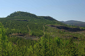
, a small tree-covered cinder cone
that last erupted about 7,200 years ago.
No damage or casualties resulted from the Nazko earthquakes, which were too small to be felt by people, but local seismographs recorded them. The earthquake swarm
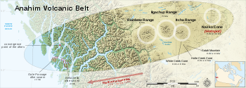
occurred at the eastern end of a known volcanic zone called the Anahim Volcanic Belt
. This is an east-west trending line of volcanic formations extending from the Central Coast
to the Central Interior of British Columbia.
s indicated that the swarm originated from a magmatic source. It could have formed as a result of rock fracturing at the tip of a dike
and/or by movement along fault planes due to changes in the local stress field
by the expansion and movement of magma
. This magmatic activity is potentially linked to the hypothesized Anahim hotspot
, a mantle plume
that is probably responsible for older volcanism
throughout the Anahim Volcanic Belt. This volcanic belt
includes the Rainbow, Ilgachuz
and Itcha
range shield volcano
es west of the Nazko swarm. Individual Anahim volcanoes generally become older to the west of the Nazko swarm, indicating that the North American Plate
is moving in a westerly direction with respect to the hotspot
, carrying the volcanoes along with it at a rate of 2 cm (0.78740157480315 in) to 3.3 cm (33 mm) per year. Because the area where the 2007–2008 Nazko earthquake swarm originated is at the eastern end of the volcanic belt, it probably represents the youngest portion of the hotspot track. This suggests any future volcanic earthquakes will occur in the Nazko region or further to the east.
 Before the Nazko earthquake swarm began in 2007, the Anahim hotspot was not known to be an earthquake zone. On October 10 of the following year, a swarm of earthquakes occurred. These earthquakes were normally no more than magnitude
1.0 on the Richter magnitude scale, but at least one earthquake was as strong as magnitude 3.9. Since the appearance of the Nazko swarm, Natural Resources Canada
has expressed interest in the adjacent 7,200 year old Nazko Cone.
Even though earthquake swarms can be dangerous, scientists are able to model such events to analyze their structure. During the earthquake swarm in 2007, a group of scientists investigated the possibility that a volcanic eruption would occur. Five additional seismographs were placed in the earthquake zone, and scientists closely monitored the seismic activity. After additional data were gathered, scientists with the United States Geological Survey
, the University of Washington
, and other organizations, agreed that the Nazko earthquakes probably originated from movement of magma beneath the surface near Nazko Cone. However, because of the number and small size of the Nazko earthquakes, no volcanic eruption is likely. Other recent earthquakes in North America that have been attributed to magma but did not result in a volcanic eruption include the 2003 earthquakes under Lake Tahoe
in the U.S. state
of California
and a 2004 earthquake swarm at Jordan Craters
in the U.S. state of Oregon
.
s were measured with poor resolution. Following the earthquake, five seismometers were placed by the Geological Survey of Canada from September 2007 to June 2008 close to the hypocenter. Analysis of the data recorded by these seismometers indicates a much larger total number of earthquakes. For example, at least 597 earthquakes were recognized during a period of only six hours.
At least two episodes of earthquakes constitute the Nazko swarm. In the first seismic phase from October 29 to November 1, 2007, a total of 153 earthquakes took place. During the second seismic phase between September 25, 2007 and June 12, 2008, 4,428 earthquakes occurred. These two seismic episodes were cross-correlated by scientists to understand changes in the development of the earthquake swarm. Correlation coefficients
were around 1.0 for the beginnings of the periods of activity, indicating almost identical situations, and then decayed to around 0.5, indicating a decrease in similarity between the later stages of the two events.
by citizen staff, three days after the earthquakes began. Scientists mentioned in the report were seismologist John Cassidy
of Natural Resources Canada and volcanologist Catherine Hickson
, who was part of the Geological Survey of Canada at the time. At the time of the report, scientists did not know the origin of the swarm. Seismologist John Cassidy stated, "the depth is enough to rule out hydrothermal but it's up in the air as to whether the cause is tectonic shifts or volcanic activity. If it is volcanic there are certain characteristics that we would expect, there's a tremor-like character to it. And so we'll be looking for the types of events that we see beneath volcanoes and we'll be looking to see if they're getting closer to the surface or if they're migrating at all."
Even if the Nazko swarm were a warning of a volcanic eruption, Hickson doubted it would turn out to be a highly explosive eruption
like those that can occur in subduction-zone
volcanoes. "We're not talking about an injection of tonnes of ash many kilometers into the air like the 1980 Mount St. Helens eruption or the 1991 Mount Pinatubo eruption. We're talking about something very small, relatively localized that should have a fairly limited impact...but it'll be extremely exciting," Hickson said. If an eruption were to occur, Hickson suggested that it would be characterized by a lava fountain
that sends globs of lava 100 m (328.1 ft) into the air. This is similar to those that occur in Hawaii. Hickson said that a Nazko eruption could be a tourist attraction, but warned that noxious gases such as carbon dioxide
and sulfur dioxide
would be released during the event.
placed seismographs in the area to monitor future earthquakes in the area more clearly. An infrasound station is also being established, which is able to measure sound waves that would normally go unnoticed by human hearing. These stations can detect volcanic eruptions and the release of gas at volcanic vents, and can be used in combination with other geophysical data to monitor fluid flow within volcanoes. Employees of Natural Resources Canada have also visited two communities that were adjacent to the 2007–2008 earthquake swarm to renew information about the Nazko swarm, collect samples, and examine some of the more poorly studied volcanic deposits in the Nazko region. The Natural Resources Canada employees also measured carbon dioxide levels during the earthquake swarm. Carbon dioxide is usually discharged at faults in volcanically active areas and can collect in soil
and under snow. Because of this, carbon dioxide concentrations can provide information on volcanic activity in the subsurface. The Nazko swarm did not cause any discernible discharge of carbon dioxide, which is normal for non-eruptive events.
 The 2007–2008 Nazko earthquake swarm is one of numerous seismic events that have occurred near volcanoes in British Columbia. Volcanoes that have experienced volcanic earthquakes include Mount Meager
(seventeen events), Mount Cayley
(four events), Mount Garibaldi
(three events), Silverthrone Caldera
(two events), Castle Rock
(two events), Hoodoo Mountain
(eight events), Crow Lagoon
(four events), The Volcano
(five events), and the Mount Edziza volcanic complex
(eight events). Seismic data suggest that these volcanoes still contain active magma chamber
s, indicating possible future eruptive activity. Although the available data do not allow a clear conclusion, these observations are indications that some of Canada's volcanoes may be active, with significant potential dangers. This seismic activity correlates both with some of Canada's most youthful volcanoes and with long-lived volcanoes with a history of significant explosive activity, such as Hoodoo Mountain and the Mount Edziza volcanic complex.
If magma were to rise towards the surface of Nazko, new earthquake swarms would occur, with a significant increase in the size and number of earthquakes. An eruption in the Nazko area would probably create a small cinder cone, similar to what formed Nazko Cone 7,200 years ago. Immediate hazards related to cinder cone eruptions in the Nazko area would probably be forest fires and, if an eruption column
were produced, redirection of nearby air traffic.
Volcano tectonic earthquake
A volcano tectonic earthquake is an earthquake induced by the movement of magma. The movement results in pressure changes in the rock around where the magma has experienced stress. At some point, the rock may break or move...
measuring less than 4.0 on the Richter magnitude scale
Richter magnitude scale
The expression Richter magnitude scale refers to a number of ways to assign a single number to quantify the energy contained in an earthquake....
. They took place in the sparsely populated Nazko
Nazko, British Columbia
Nazko is a small First Nations community located 100 km west of Quesnel on the Nazko River in central British Columbia, Canada. Nazko means, "river flowing from the south".Nazko is the gateway to the Nuxalk Carrier Grease-Alexander Mackenzie Heritage Trail...
area of the Central Interior
British Columbia Interior
The British Columbia Interior or BC Interior or Interior of British Columbia, usually referred to only as the Interior, is one of the three main regions of the Canadian province of British Columbia, the other two being the Lower Mainland, which comprises the overlapping areas of Greater Vancouver...
of British Columbia
British Columbia
British Columbia is the westernmost of Canada's provinces and is known for its natural beauty, as reflected in its Latin motto, Splendor sine occasu . Its name was chosen by Queen Victoria in 1858...
, Canada
Canada
Canada is a North American country consisting of ten provinces and three territories. Located in the northern part of the continent, it extends from the Atlantic Ocean in the east to the Pacific Ocean in the west, and northward into the Arctic Ocean...
starting on October 9, 2007 and ending on June 12, 2008. They occurred just west of Nazko Cone
Nazko Cone
Nazko Cone is a small potentially active basaltic cinder cone in central British Columbia, Canada, located 75 km west of Quesnel and 150 kilometers southwest of Prince George. It is considered the easternmost volcano in the Anahim Volcanic Belt. The small tree-covered cone rises 120 m above...
, a small tree-covered cinder cone
Cinder cone
According to the , Cinder Cone is the proper name of 1 cinder cone in Canada and 7 cinder cones in the United States:In Canada: Cinder Cone In the United States:...
that last erupted about 7,200 years ago.
No damage or casualties resulted from the Nazko earthquakes, which were too small to be felt by people, but local seismographs recorded them. The earthquake swarm
Earthquake swarm
Earthquake swarms are events where a local area experiences sequences of many earthquakes striking in a relatively short period of time. The length of time used to define the swarm itself varies, but the United States Geological Survey points out that an event may be on the order of days, weeks, or...
occurred at the eastern end of a known volcanic zone called the Anahim Volcanic Belt
Anahim Volcanic Belt
The Anahim Volcanic Belt is a long volcanic belt, stretching from just north of Vancouver Island to near Quesnel, British Columbia, Canada. The Anahim Volcanic Belt has had three main magmatic episodes: 15–13 Ma, 9–6 Ma, and 3–1 Ma. The volcanoes generally become younger eastward at a rate of to ...
. This is an east-west trending line of volcanic formations extending from the Central Coast
British Columbia Coast
The British Columbia Coast or BC Coast is Canada's western continental coastline on the Pacific Ocean. The usage is synonymous with the term West Coast of Canada....
to the Central Interior of British Columbia.
Geology
The 2007–2008 Nazko earthquake swarm is interpreted to have originated 25 km (15.5 mi) below the surface. The character of the seismic waveSeismic wave
Seismic waves are waves of energy that travel through the earth, and are a result of an earthquake, explosion, or a volcano that imparts low-frequency acoustic energy. Many other natural and anthropogenic sources create low amplitude waves commonly referred to as ambient vibrations. Seismic waves...
s indicated that the swarm originated from a magmatic source. It could have formed as a result of rock fracturing at the tip of a dike
Dike (geology)
A dike or dyke in geology is a type of sheet intrusion referring to any geologic body that cuts discordantly across* planar wall rock structures, such as bedding or foliation...
and/or by movement along fault planes due to changes in the local stress field
Stress field
A stress field is a region in a body for which the stress is defined at every point. Stress fields are widely used in fluid dynamics and materials science....
by the expansion and movement of magma
Magma
Magma is a mixture of molten rock, volatiles and solids that is found beneath the surface of the Earth, and is expected to exist on other terrestrial planets. Besides molten rock, magma may also contain suspended crystals and dissolved gas and sometimes also gas bubbles. Magma often collects in...
. This magmatic activity is potentially linked to the hypothesized Anahim hotspot
Anahim hotspot
The Anahim hotspot is a volcanic hotspot in central British Columbia, Canada. It is situated on the Interior Plateau, a large region that lies between the Cariboo and Monashee Mountains to the east, and the Hazelton Mountains, Coast Mountains and Cascade Range to the west...
, a mantle plume
Mantle plume
A mantle plume is a hypothetical thermal diapir of abnormally hot rock that nucleates at the core-mantle boundary and rises through the Earth's mantle. Such plumes were invoked in 1971 to explain volcanic regions that were not thought to be explicable by the then-new theory of plate tectonics. Some...
that is probably responsible for older volcanism
Volcanism
Volcanism is the phenomenon connected with volcanoes and volcanic activity. It includes all phenomena resulting from and causing magma within the crust or mantle of a planet to rise through the crust and form volcanic rocks on the surface....
throughout the Anahim Volcanic Belt. This volcanic belt
Volcanic belt
A volcanic belt is a large volcanically active region. Other terms are used for smaller areas of activity, such as volcanic fields. Volcanic belts are found above zones of unusually high temperature where magma is created by partial melting of solid material in the Earth's crust and upper mantle....
includes the Rainbow, Ilgachuz
Ilgachuz Range
The Ilgachuz Range is a name given to an extinct shield volcano in British Columbia, Canada. It is not a mountain range in the normal sense, because it was formed as a single volcano that has been eroded for the past 5 million years. It lies on the Chilcotin Plateau, located some north-northwest...
and Itcha
Itcha Range
The Itcha Range is a mountain range on the Chilcotin Plateau of the West-Central Interior of British Columbia, Canada. The range is located 25 miles northeast of Anahim Lake...
range shield volcano
Shield volcano
A shield volcano is a type of volcano usually built almost entirely of fluid lava flows. They are named for their large size and low profile, resembling a warrior's shield. This is caused by the highly fluid lava they erupt, which travels farther than lava erupted from more explosive volcanoes...
es west of the Nazko swarm. Individual Anahim volcanoes generally become older to the west of the Nazko swarm, indicating that the North American Plate
North American Plate
The North American Plate is a tectonic plate covering most of North America, Greenland, Cuba, Bahamas, and parts of Siberia, Japan and Iceland. It extends eastward to the Mid-Atlantic Ridge and westward to the Chersky Range in eastern Siberia. The plate includes both continental and oceanic crust...
is moving in a westerly direction with respect to the hotspot
Hotspot (geology)
The places known as hotspots or hot spots in geology are volcanic regions thought to be fed by underlying mantle that is anomalously hot compared with the mantle elsewhere. They may be on, near to, or far from tectonic plate boundaries. There are two hypotheses to explain them...
, carrying the volcanoes along with it at a rate of 2 cm (0.78740157480315 in) to 3.3 cm (33 mm) per year. Because the area where the 2007–2008 Nazko earthquake swarm originated is at the eastern end of the volcanic belt, it probably represents the youngest portion of the hotspot track. This suggests any future volcanic earthquakes will occur in the Nazko region or further to the east.
Magnitude (mathematics)
The magnitude of an object in mathematics is its size: a property by which it can be compared as larger or smaller than other objects of the same kind; in technical terms, an ordering of the class of objects to which it belongs....
1.0 on the Richter magnitude scale, but at least one earthquake was as strong as magnitude 3.9. Since the appearance of the Nazko swarm, Natural Resources Canada
Natural Resources Canada
The Department of Natural Resources , operating under the FIP applied title Natural Resources Canada , is the ministry of the government of Canada responsible for natural resources, energy, minerals and metals, forests, earth sciences, mapping and remote sensing...
has expressed interest in the adjacent 7,200 year old Nazko Cone.
Even though earthquake swarms can be dangerous, scientists are able to model such events to analyze their structure. During the earthquake swarm in 2007, a group of scientists investigated the possibility that a volcanic eruption would occur. Five additional seismographs were placed in the earthquake zone, and scientists closely monitored the seismic activity. After additional data were gathered, scientists with the United States Geological Survey
United States Geological Survey
The United States Geological Survey is a scientific agency of the United States government. The scientists of the USGS study the landscape of the United States, its natural resources, and the natural hazards that threaten it. The organization has four major science disciplines, concerning biology,...
, the University of Washington
University of Washington
University of Washington is a public research university, founded in 1861 in Seattle, Washington, United States. The UW is the largest university in the Northwest and the oldest public university on the West Coast. The university has three campuses, with its largest campus in the University...
, and other organizations, agreed that the Nazko earthquakes probably originated from movement of magma beneath the surface near Nazko Cone. However, because of the number and small size of the Nazko earthquakes, no volcanic eruption is likely. Other recent earthquakes in North America that have been attributed to magma but did not result in a volcanic eruption include the 2003 earthquakes under Lake Tahoe
Lake Tahoe
Lake Tahoe is a large freshwater lake in the Sierra Nevada of the United States. At a surface elevation of , it is located along the border between California and Nevada, west of Carson City. Lake Tahoe is the largest alpine lake in North America. Its depth is , making it the USA's second-deepest...
in the U.S. state
U.S. state
A U.S. state is any one of the 50 federated states of the United States of America that share sovereignty with the federal government. Because of this shared sovereignty, an American is a citizen both of the federal entity and of his or her state of domicile. Four states use the official title of...
of California
California
California is a state located on the West Coast of the United States. It is by far the most populous U.S. state, and the third-largest by land area...
and a 2004 earthquake swarm at Jordan Craters
Jordan Craters
Portions of this article include public domain text from the USFS .The flows of Jordan Craters volcanic field are the youngest of a large Quaternary basalt fields in the eastern part of the U.S. state of Oregon. The most recent flows come from Coffeepot Crater, a large breached cinder cone...
in the U.S. state of Oregon
Oregon
Oregon is a state in the Pacific Northwest region of the United States. It is located on the Pacific coast, with Washington to the north, California to the south, Nevada on the southeast and Idaho to the east. The Columbia and Snake rivers delineate much of Oregon's northern and eastern...
.
Number of earthquakes
More than 1,000 earthquakes were recorded by regional seismic networks within three weeks of October 20, 2007. Because the seismometers that recorded the Nazko swarm were more than 25 km (15.5 mi) away from where the earthquakes took place, the locations of the hypocenterHypocenter
The hypocenter refers to the site of an earthquake or a nuclear explosion...
s were measured with poor resolution. Following the earthquake, five seismometers were placed by the Geological Survey of Canada from September 2007 to June 2008 close to the hypocenter. Analysis of the data recorded by these seismometers indicates a much larger total number of earthquakes. For example, at least 597 earthquakes were recognized during a period of only six hours.
At least two episodes of earthquakes constitute the Nazko swarm. In the first seismic phase from October 29 to November 1, 2007, a total of 153 earthquakes took place. During the second seismic phase between September 25, 2007 and June 12, 2008, 4,428 earthquakes occurred. These two seismic episodes were cross-correlated by scientists to understand changes in the development of the earthquake swarm. Correlation coefficients
Pearson product-moment correlation coefficient
In statistics, the Pearson product-moment correlation coefficient is a measure of the correlation between two variables X and Y, giving a value between +1 and −1 inclusive...
were around 1.0 for the beginnings of the periods of activity, indicating almost identical situations, and then decayed to around 0.5, indicating a decrease in similarity between the later stages of the two events.
Scientific response
The earthquake swarm was noted on October 12, 2007 in the Prince George CitizenPrince George Citizen
The Prince George Citizen is a daily newspaper located in Prince George, British Columbia, Canada. The paper was established in 1916. Issues from 1916-1971+ are now available online in the Prince George Newspapers database, an ongoing collaborative library project....
by citizen staff, three days after the earthquakes began. Scientists mentioned in the report were seismologist John Cassidy
John Cassidy (seismologist)
John Francis Cassidy is a Canadian seismologist and an Adjunct Professor of the University of Victoria in British Columbia, Canada. He lives in the town of Sidney on southern Vancouver Island and is part of Natural Resources Canada...
of Natural Resources Canada and volcanologist Catherine Hickson
Catherine Hickson
Catherine Hickson is a Canadian volcanologist formerly part of the Geological Survey of Canada. Hickson has mapped and studied young volcanoes in Canada assessing their past and future eruptions. In 2003, Hickson was one of the three scientists to report on a hypothetical eruption at the Canadian...
, who was part of the Geological Survey of Canada at the time. At the time of the report, scientists did not know the origin of the swarm. Seismologist John Cassidy stated, "the depth is enough to rule out hydrothermal but it's up in the air as to whether the cause is tectonic shifts or volcanic activity. If it is volcanic there are certain characteristics that we would expect, there's a tremor-like character to it. And so we'll be looking for the types of events that we see beneath volcanoes and we'll be looking to see if they're getting closer to the surface or if they're migrating at all."
Even if the Nazko swarm were a warning of a volcanic eruption, Hickson doubted it would turn out to be a highly explosive eruption
Explosive eruption
An explosive eruption is a volcanic term to describe a violent, explosive type of eruption. Mount St. Helens in 1980 was an example. Such an eruption is driven by gas accumulating under great pressure. Driven by hot rising magma, it interacts with ground water until the pressure increases to the...
like those that can occur in subduction-zone
Subduction
In geology, subduction is the process that takes place at convergent boundaries by which one tectonic plate moves under another tectonic plate, sinking into the Earth's mantle, as the plates converge. These 3D regions of mantle downwellings are known as "Subduction Zones"...
volcanoes. "We're not talking about an injection of tonnes of ash many kilometers into the air like the 1980 Mount St. Helens eruption or the 1991 Mount Pinatubo eruption. We're talking about something very small, relatively localized that should have a fairly limited impact...but it'll be extremely exciting," Hickson said. If an eruption were to occur, Hickson suggested that it would be characterized by a lava fountain
Lava fountain
A lava fountain is a volcanic phenomenon in which lava is forcefully but non-explosively ejected from a crater, vent, or fissure. Lava fountains may reach heights of up to . They may occur as a series of short pulses, or a continuous jet of lava. They are commonly seen in Hawaiian eruptions.-See...
that sends globs of lava 100 m (328.1 ft) into the air. This is similar to those that occur in Hawaii. Hickson said that a Nazko eruption could be a tourist attraction, but warned that noxious gases such as carbon dioxide
Carbon dioxide
Carbon dioxide is a naturally occurring chemical compound composed of two oxygen atoms covalently bonded to a single carbon atom...
and sulfur dioxide
Sulfur dioxide
Sulfur dioxide is the chemical compound with the formula . It is released by volcanoes and in various industrial processes. Since coal and petroleum often contain sulfur compounds, their combustion generates sulfur dioxide unless the sulfur compounds are removed before burning the fuel...
would be released during the event.
Preparedness and hazards
Because no seismographs were close enough to the Nazko swarm zone before the earthquakes began, employees of Natural Resources CanadaNatural Resources Canada
The Department of Natural Resources , operating under the FIP applied title Natural Resources Canada , is the ministry of the government of Canada responsible for natural resources, energy, minerals and metals, forests, earth sciences, mapping and remote sensing...
placed seismographs in the area to monitor future earthquakes in the area more clearly. An infrasound station is also being established, which is able to measure sound waves that would normally go unnoticed by human hearing. These stations can detect volcanic eruptions and the release of gas at volcanic vents, and can be used in combination with other geophysical data to monitor fluid flow within volcanoes. Employees of Natural Resources Canada have also visited two communities that were adjacent to the 2007–2008 earthquake swarm to renew information about the Nazko swarm, collect samples, and examine some of the more poorly studied volcanic deposits in the Nazko region. The Natural Resources Canada employees also measured carbon dioxide levels during the earthquake swarm. Carbon dioxide is usually discharged at faults in volcanically active areas and can collect in soil
Soil
Soil is a natural body consisting of layers of mineral constituents of variable thicknesses, which differ from the parent materials in their morphological, physical, chemical, and mineralogical characteristics...
and under snow. Because of this, carbon dioxide concentrations can provide information on volcanic activity in the subsurface. The Nazko swarm did not cause any discernible discharge of carbon dioxide, which is normal for non-eruptive events.
Mount Meager
Mount Meager, originally known as Meager Mountain, is a complex volcano in the Sea-to-Sky Corridor of southwestern British Columbia, Canada. It is located north of Vancouver at the northern end of the Pemberton Valley. Part of the Cascade Volcanic Arc of western North America, its summit is above...
(seventeen events), Mount Cayley
Mount Cayley
Mount Cayley is a potentially active stratovolcano in Squamish-Lillooet Regional District of southwestern British Columbia, Canada. Located north of Squamish and west of Whistler in the Pacific Ranges of the Coast Mountains, it rises above the Squamish River to the west and above the Cheakamus...
(four events), Mount Garibaldi
Mount Garibaldi
Mount Garibaldi is a potentially active stratovolcano in the Sea to Sky Country of British Columbia, north of Vancouver, Canada. Located in the southernmost Coast Mountains, it is one of the most recognized peaks in the South Coast region, as well as British Columbia's best known volcano...
(three events), Silverthrone Caldera
Silverthrone Caldera
The Silverthrone Caldera is a potentially active caldera complex in southwestern British Columbia, Canada, located over northwest of the city of Vancouver and about west of Mount Waddington in the Pacific Ranges of the Coast Mountains. The caldera is one of the largest of the few calderas in...
(two events), Castle Rock
Castle Rock (volcano)
Castle Rock is a volcanic neck located west of Iskut and 8 km northwest of Tuktsayda Mountain in British Columbia, Canada. It is part of the Pacific Ring of Fire that includes over 160 active volcanoes and is in the Klastline Group, Northern Cordilleran Volcanic Province and last erupted in...
(two events), Hoodoo Mountain
Hoodoo Mountain
Hoodoo Mountain is a potentially active flat-topped stratovolcano in the Stikine Country of northwestern British Columbia, Canada, located northeast of Wrangell, Alaska on the north side of the lower Iskut River and east of its junction with the Stikine River...
(eight events), Crow Lagoon
Crow Lagoon
Crow Lagoon is a little-known volcanic center located north of Prince Rupert, British Columbia, Canada. There are beds of thick, basaltic tephra that are of Holocene age....
(four events), The Volcano
The Volcano (British Columbia)
The Volcano, also known as Lava Fork volcano, is a small cinder cone in the Boundary Ranges of the Coast Mountains in northwestern British Columbia, Canada. It is located approximately northwest of the small community of Stewart near the head of Lava Fork...
(five events), and the Mount Edziza volcanic complex
Mount Edziza volcanic complex
The Mount Edziza volcanic complex is a large and potentially active north-south trending complex volcano in Stikine Country, northwestern British Columbia, Canada, located southeast of the small community of Telegraph Creek...
(eight events). Seismic data suggest that these volcanoes still contain active magma chamber
Magma chamber
A magma chamber is a large underground pool of molten rock found beneath the surface of the Earth. The molten rock in such a chamber is under great pressure, and given enough time, that pressure can gradually fracture the rock around it creating outlets for the magma...
s, indicating possible future eruptive activity. Although the available data do not allow a clear conclusion, these observations are indications that some of Canada's volcanoes may be active, with significant potential dangers. This seismic activity correlates both with some of Canada's most youthful volcanoes and with long-lived volcanoes with a history of significant explosive activity, such as Hoodoo Mountain and the Mount Edziza volcanic complex.
If magma were to rise towards the surface of Nazko, new earthquake swarms would occur, with a significant increase in the size and number of earthquakes. An eruption in the Nazko area would probably create a small cinder cone, similar to what formed Nazko Cone 7,200 years ago. Immediate hazards related to cinder cone eruptions in the Nazko area would probably be forest fires and, if an eruption column
Eruption column
An eruption column consists of hot volcanic ash emitted during an explosive volcanic eruption. The ash forms a column rising many kilometres into the air above the peak of the volcano. In the most explosive eruptions, the eruption column may rise over 40 km, penetrating the stratosphere...
were produced, redirection of nearby air traffic.
See also
- List of earthquakes in Canada
- Volcanism of Canada
- Volcanism of Western CanadaVolcanism of Western CanadaVolcanism of Western Canada produces lava flows, lava plateaus, lava domes, cinder cones, stratovolcanoes, shield volcanoes, submarine volcanoes, calderas, diatremes and maars, along with examples of more less common volcanic forms such as tuyas and subglacial mounds.-Volcanic belts:*Anahim...