

Ilgachuz Range
Encyclopedia
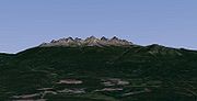
The Ilgachuz Range is a name given to an extinct shield volcano
in British Columbia
, Canada
. It is not a mountain range
in the normal sense, because it was formed as a single volcano that has been eroded
for the past 5 million years. It lies on the Chilcotin Plateau
, located some 350 kilometres (217.5 mi) north-northwest of Vancouver
and 30 km north of Anahim Lake. The highest peak of the range is Far Mountain
. The range supports a unique grassland
ecosystem. This type of grassland has not been seen anywhere else in central and southern British Columbia. The climate is cool and dry; typical of higher elevations of the Interior Plateau
.
The 280 kilometres (174 mi) long West Road River
rises in the Ilgachuz Range and flows east to its confluence with the Fraser River
between Prince George
and Quesnel
. It drains an area of approximately 12,000 sq kilometers, and dropping over 900 meters before joining with the Fraser.
 The Ilgachuz Range began erupting about 5 million years ago and has grown steadily since then. Like all of the Anahim volcanoes, the Ilgachuz Range has its origins in the Anahim hotspot
—a plume of magma
rising from the Earth's mantle
in central British Columbia
. The hotspot remains in a fixed position, while the North American Plate
drifts over it at a rate of 2 to 3.3 centimetres per year. The upwelling of the hot magma creates volcanoes, and each individual volcano erupts for a few million years before the movement of the plate carries it away from the rising magma. However, where hotspots occur under continental crust
, basaltic magma is trapped in the less dense continental crust, which is heated and melts to form rhyolite
s. These rhyolites can be quite hot and form violent eruptions, despite their low water content.
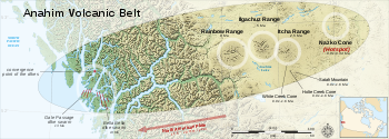
The hotspot has existed for at least 13 million years, and the Anahim Volcanic Belt stretches almost 600 kilometres (372.8 mi) away from the hotspot. More recently, the hotspot has formed the Itcha Range
and Nazko Cone
, a cinder cone
east of the Ilgachuz Range and the youngest Anahim volcano. The Ilgachuz Range is the largest of these, although the Rainbow Range
is the largest of all volcanoes in the Anahim Volcanic Belt.
and Chilcotin
tribes. They have lived in the area for hundreds of years, travelling when necessary to hunt and trap animals such as beaver
, caribou, moose
, and to gather plant
s and root
s. Fishing camps were also established in the area.
The Ilgachuz Range is, or was, an important source of obsidian
for the South Carrier and Chilcotin tribes. Obsidian was greatly desired because very sharp arrowhead
s and cutting knives
could be made from it. Like all glass
and some other types of naturally occurring rocks, obsidian breaks with a characteristic conchoidal fracture
, creating razorlike edges. It was also used for jewelry. Anahim obsidian was traded extensively throughout the BC Interior and up and down the Coast from Bella Coola
. Red ochre used in paint
and decoration was also obtained from this area.
 The Ilgachuz Range is the second largest shield volcano
in the Anahim Volcanic Belt
which includes other immediately nearby ranges, the Rainbow Range
and Itcha Range
. It stands at 2410 metres (7,907 ft) above sea level - slightly shorter than its neighbor, Rainbow Range. It has a diameter of 25 km (16 mi). The Ilgachuz Range was created by two chemically separate magmatic periods; an early complex series of trachyte
and rhyolite
eruptions, and late extrusion of a sequence of basalt
ic lava flows. Evacuation of the volcano's magma chamber
resulted in the failure of one or more centrally located caldera
s. It is divided into Precaldera, Dome Forming, Intra Caldera and Shield Forming assembages.
The Precaldera Assemblage is best exposed on the east side of Pipe Organ Mountain where it contains a bedded pile over 300 m thick of weakly consolidated, moderately to extremely different, pyroclastic
s, flows and deposits of uncertain origin. Colours range from mottled green
to grey
, yellow
, ochre
, red
and white
. A green tuff
breccia composed of pumice
fragments, feldspar
crystal
s and minor debris
is recognizable in several areas.
The Dome Forming Assemblages include most of the rhyolite domes, related flows and the Ilgachuz Comendite. The northerly domes are subcircular talus mounds of plate sized pieces of light to dark grey, slightly porphyritic, flowbanded rhyolite with minor obsidian
. Massive to banded chalcedony blobs and veinlets are related with these domes. The southern domes are somewhat different in nature, comprising intrusive and extrusive phases of cream colored porphyries. The Sax Dome contains an upper portion of cream colored, aphanitic to fine quartz porphyry felsite with abnormal green glass filled fractures, and a lower unit of microsyenite with red and green glassy zenocrysts.
The Intra Caldera Assemblage is best exposed on the north edge of the caldera. The lower unit, indicative of caldera formation, is an epiclastic boulder-landslide deposit, roughly bedded and dipping into the caldera. Similar material, grading up into finer debris flows and possibly lahar
s, has been uncertainly known in the gap between Phacelia Peak and Calliope Mountain suggesting this area is the southern edge of the caldera. Alternatively, largely unsorted breccia
and debris deposits exist on the ridge north of Saxifraga Peak, possibly indicating the main, or a subsidiary, caldera edge.
The Shield Forming Assemblage contains a series of basalt
and minor comendite eruptions, and is best exposed on Far Mountain
and Mount Scot. The basalts issued from fissure vent
s primarily located peripheral to the calderas. Brick red cinder deposits are considered to be a late phase of this assemblage.
, a 112,000 hecture park of unique landscape in the West Chilcotin Uplands while the Rainbow Range
lies partly in the Tweedsmuir South Provincial Park
. The park includes volcanic landforms, alpine environments, and forest
sites scattered with wetland
s.
Itcha Ilgachuz Provincial Park is extremely remote and unroaded; the closest communities are Anahim Lake, Alexis Creek
, Nimpo Lake
, Redstone
, and Nazko
. The closest major center is Quesnel
, located approximately 200 km east of the park.
Shield volcano
A shield volcano is a type of volcano usually built almost entirely of fluid lava flows. They are named for their large size and low profile, resembling a warrior's shield. This is caused by the highly fluid lava they erupt, which travels farther than lava erupted from more explosive volcanoes...
in British Columbia
British Columbia
British Columbia is the westernmost of Canada's provinces and is known for its natural beauty, as reflected in its Latin motto, Splendor sine occasu . Its name was chosen by Queen Victoria in 1858...
, Canada
Canada
Canada is a North American country consisting of ten provinces and three territories. Located in the northern part of the continent, it extends from the Atlantic Ocean in the east to the Pacific Ocean in the west, and northward into the Arctic Ocean...
. It is not a mountain range
Mountain range
A mountain range is a single, large mass consisting of a succession of mountains or narrowly spaced mountain ridges, with or without peaks, closely related in position, direction, formation, and age; a component part of a mountain system or of a mountain chain...
in the normal sense, because it was formed as a single volcano that has been eroded
Erosion
Erosion is when materials are removed from the surface and changed into something else. It only works by hydraulic actions and transport of solids in the natural environment, and leads to the deposition of these materials elsewhere...
for the past 5 million years. It lies on the Chilcotin Plateau
Chilcotin Plateau
The Chilcotin Plateau is part of the Fraser Plateau, a major subdivision of the Interior Plateau of British Columbia. The Chilcotin Plateau is physically near-identical with the region of the same name, i.e...
, located some 350 kilometres (217.5 mi) north-northwest of Vancouver
Vancouver
Vancouver is a coastal seaport city on the mainland of British Columbia, Canada. It is the hub of Greater Vancouver, which, with over 2.3 million residents, is the third most populous metropolitan area in the country,...
and 30 km north of Anahim Lake. The highest peak of the range is Far Mountain
Far Mountain
Far Mountain is the highest of the 13 peaks of the Ilgachuz Range in the Anahim Volcanic Belt in British Columbia, Canada. The Ilgachuz Range is one of the three major shield volcanoes that formed the Anahim Volcanic Belt when the North American Plate moved over a hotspot . This is similar to the...
. The range supports a unique grassland
Grassland
Grasslands are areas where the vegetation is dominated by grasses and other herbaceous plants . However, sedge and rush families can also be found. Grasslands occur naturally on all continents except Antarctica...
ecosystem. This type of grassland has not been seen anywhere else in central and southern British Columbia. The climate is cool and dry; typical of higher elevations of the Interior Plateau
Interior Plateau
The Interior Plateau comprises a large region of central British Columbia, and lies between the Cariboo and Monashee Mountains on the east, and the Hazelton Mountains, Coast Mountains and Cascade Range on the west. The continuation of the plateau into the United States is known there as the...
.
The 280 kilometres (174 mi) long West Road River
West Road River
The West Road River or Blackwater River is a major tributary of the Fraser River, flowing generally north-eastward from the northern slopes of the Ilgachuz Range and across the Fraser Plateau in the Chilcotin region of central British Columbia, Canada...
rises in the Ilgachuz Range and flows east to its confluence with the Fraser River
Fraser River
The Fraser River is the longest river within British Columbia, Canada, rising at Fraser Pass near Mount Robson in the Rocky Mountains and flowing for , into the Strait of Georgia at the city of Vancouver. It is the tenth longest river in Canada...
between Prince George
Prince George, British Columbia
Prince George, with a population of 71,030 , is the largest city in northern British Columbia, Canada, and is known as "BC's Northern Capital"...
and Quesnel
Quesnel, British Columbia
-Demographics:Quesnel had a population of 9,326 people in 2006, which was a decrease of 7.1% from the 2001 census count. The median household income in 2005 for Quesnel was $54,044, which is slightly above the British Columbia provincial average of $52,709....
. It drains an area of approximately 12,000 sq kilometers, and dropping over 900 meters before joining with the Fraser.
Origins
Anahim hotspot
The Anahim hotspot is a volcanic hotspot in central British Columbia, Canada. It is situated on the Interior Plateau, a large region that lies between the Cariboo and Monashee Mountains to the east, and the Hazelton Mountains, Coast Mountains and Cascade Range to the west...
—a plume of magma
Magma
Magma is a mixture of molten rock, volatiles and solids that is found beneath the surface of the Earth, and is expected to exist on other terrestrial planets. Besides molten rock, magma may also contain suspended crystals and dissolved gas and sometimes also gas bubbles. Magma often collects in...
rising from the Earth's mantle
Mantle (geology)
The mantle is a part of a terrestrial planet or other rocky body large enough to have differentiation by density. The interior of the Earth, similar to the other terrestrial planets, is chemically divided into layers. The mantle is a highly viscous layer between the crust and the outer core....
in central British Columbia
British Columbia
British Columbia is the westernmost of Canada's provinces and is known for its natural beauty, as reflected in its Latin motto, Splendor sine occasu . Its name was chosen by Queen Victoria in 1858...
. The hotspot remains in a fixed position, while the North American Plate
North American Plate
The North American Plate is a tectonic plate covering most of North America, Greenland, Cuba, Bahamas, and parts of Siberia, Japan and Iceland. It extends eastward to the Mid-Atlantic Ridge and westward to the Chersky Range in eastern Siberia. The plate includes both continental and oceanic crust...
drifts over it at a rate of 2 to 3.3 centimetres per year. The upwelling of the hot magma creates volcanoes, and each individual volcano erupts for a few million years before the movement of the plate carries it away from the rising magma. However, where hotspots occur under continental crust
Continental crust
The continental crust is the layer of igneous, sedimentary, and metamorphic rocks which form the continents and the areas of shallow seabed close to their shores, known as continental shelves. This layer is sometimes called sial due to more felsic, or granitic, bulk composition, which lies in...
, basaltic magma is trapped in the less dense continental crust, which is heated and melts to form rhyolite
Rhyolite
This page is about a volcanic rock. For the ghost town see Rhyolite, Nevada, and for the satellite system, see Rhyolite/Aquacade.Rhyolite is an igneous, volcanic rock, of felsic composition . It may have any texture from glassy to aphanitic to porphyritic...
s. These rhyolites can be quite hot and form violent eruptions, despite their low water content.
The hotspot has existed for at least 13 million years, and the Anahim Volcanic Belt stretches almost 600 kilometres (372.8 mi) away from the hotspot. More recently, the hotspot has formed the Itcha Range
Itcha Range
The Itcha Range is a mountain range on the Chilcotin Plateau of the West-Central Interior of British Columbia, Canada. The range is located 25 miles northeast of Anahim Lake...
and Nazko Cone
Nazko Cone
Nazko Cone is a small potentially active basaltic cinder cone in central British Columbia, Canada, located 75 km west of Quesnel and 150 kilometers southwest of Prince George. It is considered the easternmost volcano in the Anahim Volcanic Belt. The small tree-covered cone rises 120 m above...
, a cinder cone
Cinder cone
According to the , Cinder Cone is the proper name of 1 cinder cone in Canada and 7 cinder cones in the United States:In Canada: Cinder Cone In the United States:...
east of the Ilgachuz Range and the youngest Anahim volcano. The Ilgachuz Range is the largest of these, although the Rainbow Range
Rainbow Range (Coast Mountains)
The Rainbow Range, formerly known as the Rainbow Mountains, is a mountain range in British Columbia, Canada, located northwest of Anahim Lake...
is the largest of all volcanoes in the Anahim Volcanic Belt.
First Nations
The first recorded ascent of the Ilgachuz Range was by the South CarrierDakelh
The Dakelh or Carrier are the indigenous people of a large portion of the Central Interior of British Columbia, Canada.Most Carrier call themselves Dakelh, meaning "people who go around by boat"...
and Chilcotin
Tsilhqot'in
The Tsilhqot'in are a Northern Athabaskan First Nations people that live in British Columbia, Canada...
tribes. They have lived in the area for hundreds of years, travelling when necessary to hunt and trap animals such as beaver
Beaver
The beaver is a primarily nocturnal, large, semi-aquatic rodent. Castor includes two extant species, North American Beaver and Eurasian Beaver . Beavers are known for building dams, canals, and lodges . They are the second-largest rodent in the world...
, caribou, moose
Moose
The moose or Eurasian elk is the largest extant species in the deer family. Moose are distinguished by the palmate antlers of the males; other members of the family have antlers with a dendritic configuration...
, and to gather plant
Plant
Plants are living organisms belonging to the kingdom Plantae. Precise definitions of the kingdom vary, but as the term is used here, plants include familiar organisms such as trees, flowers, herbs, bushes, grasses, vines, ferns, mosses, and green algae. The group is also called green plants or...
s and root
Root
In vascular plants, the root is the organ of a plant that typically lies below the surface of the soil. This is not always the case, however, since a root can also be aerial or aerating . Furthermore, a stem normally occurring below ground is not exceptional either...
s. Fishing camps were also established in the area.
The Ilgachuz Range is, or was, an important source of obsidian
Obsidian
Obsidian is a naturally occurring volcanic glass formed as an extrusive igneous rock.It is produced when felsic lava extruded from a volcano cools rapidly with minimum crystal growth...
for the South Carrier and Chilcotin tribes. Obsidian was greatly desired because very sharp arrowhead
Arrowhead
An arrowhead is a tip, usually sharpened, added to an arrow to make it more deadly or to fulfill some special purpose. Historically arrowheads were made of stone and of organic materials; as human civilization progressed other materials were used...
s and cutting knives
Knife
A knife is a cutting tool with an exposed cutting edge or blade, hand-held or otherwise, with or without a handle. Knives were used at least two-and-a-half million years ago, as evidenced by the Oldowan tools...
could be made from it. Like all glass
Glass
Glass is an amorphous solid material. Glasses are typically brittle and optically transparent.The most familiar type of glass, used for centuries in windows and drinking vessels, is soda-lime glass, composed of about 75% silica plus Na2O, CaO, and several minor additives...
and some other types of naturally occurring rocks, obsidian breaks with a characteristic conchoidal fracture
Conchoidal fracture
Conchoidal fracture describes the way that brittle materials break when they do not follow any natural planes of separation. Materials that break in this way include flint and other fine-grained minerals, as well as most amorphous solids, such as obsidian and other types of glass.Conchoidal...
, creating razorlike edges. It was also used for jewelry. Anahim obsidian was traded extensively throughout the BC Interior and up and down the Coast from Bella Coola
Bella Coola
Bella Coola may refer to several things, all closely related to a geographic area within British Columbia's Central Coast:*The Nuxalk, an indigenous people of the area who in the past had been referred to as the Bella Coola...
. Red ochre used in paint
Paint
Paint is any liquid, liquefiable, or mastic composition which after application to a substrate in a thin layer is converted to an opaque solid film. One may also consider the digital mimicry thereof...
and decoration was also obtained from this area.
Structure
Shield volcano
A shield volcano is a type of volcano usually built almost entirely of fluid lava flows. They are named for their large size and low profile, resembling a warrior's shield. This is caused by the highly fluid lava they erupt, which travels farther than lava erupted from more explosive volcanoes...
in the Anahim Volcanic Belt
Anahim Volcanic Belt
The Anahim Volcanic Belt is a long volcanic belt, stretching from just north of Vancouver Island to near Quesnel, British Columbia, Canada. The Anahim Volcanic Belt has had three main magmatic episodes: 15–13 Ma, 9–6 Ma, and 3–1 Ma. The volcanoes generally become younger eastward at a rate of to ...
which includes other immediately nearby ranges, the Rainbow Range
Rainbow Range (Coast Mountains)
The Rainbow Range, formerly known as the Rainbow Mountains, is a mountain range in British Columbia, Canada, located northwest of Anahim Lake...
and Itcha Range
Itcha Range
The Itcha Range is a mountain range on the Chilcotin Plateau of the West-Central Interior of British Columbia, Canada. The range is located 25 miles northeast of Anahim Lake...
. It stands at 2410 metres (7,907 ft) above sea level - slightly shorter than its neighbor, Rainbow Range. It has a diameter of 25 km (16 mi). The Ilgachuz Range was created by two chemically separate magmatic periods; an early complex series of trachyte
Trachyte
Trachyte is an igneous volcanic rock with an aphanitic to porphyritic texture. The mineral assemblage consists of essential alkali feldspar; relatively minor plagioclase and quartz or a feldspathoid such as nepheline may also be present....
and rhyolite
Rhyolite
This page is about a volcanic rock. For the ghost town see Rhyolite, Nevada, and for the satellite system, see Rhyolite/Aquacade.Rhyolite is an igneous, volcanic rock, of felsic composition . It may have any texture from glassy to aphanitic to porphyritic...
eruptions, and late extrusion of a sequence of basalt
Basalt
Basalt is a common extrusive volcanic rock. It is usually grey to black and fine-grained due to rapid cooling of lava at the surface of a planet. It may be porphyritic containing larger crystals in a fine matrix, or vesicular, or frothy scoria. Unweathered basalt is black or grey...
ic lava flows. Evacuation of the volcano's magma chamber
Magma chamber
A magma chamber is a large underground pool of molten rock found beneath the surface of the Earth. The molten rock in such a chamber is under great pressure, and given enough time, that pressure can gradually fracture the rock around it creating outlets for the magma...
resulted in the failure of one or more centrally located caldera
Caldera
A caldera is a cauldron-like volcanic feature usually formed by the collapse of land following a volcanic eruption, such as the one at Yellowstone National Park in the US. They are sometimes confused with volcanic craters...
s. It is divided into Precaldera, Dome Forming, Intra Caldera and Shield Forming assembages.
The Precaldera Assemblage is best exposed on the east side of Pipe Organ Mountain where it contains a bedded pile over 300 m thick of weakly consolidated, moderately to extremely different, pyroclastic
Pyroclastic rock
Pyroclastic rocks or pyroclastics are clastic rocks composed solely or primarily of volcanic materials. Where the volcanic material has been transported and reworked through mechanical action, such as by wind or water, these rocks are termed volcaniclastic...
s, flows and deposits of uncertain origin. Colours range from mottled green
Green
Green is a color, the perception of which is evoked by light having a spectrum dominated by energy with a wavelength of roughly 520–570 nanometres. In the subtractive color system, it is not a primary color, but is created out of a mixture of yellow and blue, or yellow and cyan; it is considered...
to grey
Grey
Grey or gray is an achromatic or neutral color.Complementary colors are defined to mix to grey, either additively or subtractively, and many color models place complements opposite each other in a color wheel. To produce grey in RGB displays, the R, G, and B primary light sources are combined in...
, yellow
Yellow
Yellow is the color evoked by light that stimulates both the L and M cone cells of the retina about equally, with no significant stimulation of the S cone cells. Light with a wavelength of 570–590 nm is yellow, as is light with a suitable mixture of red and green...
, ochre
Ochre
Ochre is the term for both a golden-yellow or light yellow brown color and for a form of earth pigment which produces the color. The pigment can also be used to create a reddish tint known as "red ochre". The more rarely used terms "purple ochre" and "brown ochre" also exist for variant hues...
, red
Red
Red is any of a number of similar colors evoked by light consisting predominantly of the longest wavelengths of light discernible by the human eye, in the wavelength range of roughly 630–740 nm. Longer wavelengths than this are called infrared , and cannot be seen by the naked eye...
and white
White
White is a color, the perception of which is evoked by light that stimulates all three types of color sensitive cone cells in the human eye in nearly equal amounts and with high brightness compared to the surroundings. A white visual stimulation will be void of hue and grayness.White light can be...
. A green tuff
Tuff
Tuff is a type of rock consisting of consolidated volcanic ash ejected from vents during a volcanic eruption. Tuff is sometimes called tufa, particularly when used as construction material, although tufa also refers to a quite different rock. Rock that contains greater than 50% tuff is considered...
breccia composed of pumice
Pumice
Pumice is a textural term for a volcanic rock that is a solidified frothy lava typically created when super-heated, highly pressurized rock is violently ejected from a volcano. It can be formed when lava and water are mixed. This unusual formation is due to the simultaneous actions of rapid...
fragments, feldspar
Feldspar
Feldspars are a group of rock-forming tectosilicate minerals which make up as much as 60% of the Earth's crust....
crystal
Crystal
A crystal or crystalline solid is a solid material whose constituent atoms, molecules, or ions are arranged in an orderly repeating pattern extending in all three spatial dimensions. The scientific study of crystals and crystal formation is known as crystallography...
s and minor debris
Debris
Debris is rubble, wreckage, ruins, litter and discarded garbage/refuse/trash, scattered remains of something destroyed, or, in geology, large rock fragments left by a melting glacier etc. The singular form of debris is debris...
is recognizable in several areas.
The Dome Forming Assemblages include most of the rhyolite domes, related flows and the Ilgachuz Comendite. The northerly domes are subcircular talus mounds of plate sized pieces of light to dark grey, slightly porphyritic, flowbanded rhyolite with minor obsidian
Obsidian
Obsidian is a naturally occurring volcanic glass formed as an extrusive igneous rock.It is produced when felsic lava extruded from a volcano cools rapidly with minimum crystal growth...
. Massive to banded chalcedony blobs and veinlets are related with these domes. The southern domes are somewhat different in nature, comprising intrusive and extrusive phases of cream colored porphyries. The Sax Dome contains an upper portion of cream colored, aphanitic to fine quartz porphyry felsite with abnormal green glass filled fractures, and a lower unit of microsyenite with red and green glassy zenocrysts.
The Intra Caldera Assemblage is best exposed on the north edge of the caldera. The lower unit, indicative of caldera formation, is an epiclastic boulder-landslide deposit, roughly bedded and dipping into the caldera. Similar material, grading up into finer debris flows and possibly lahar
Lahar
A lahar is a type of mudflow or debris flow composed of a slurry of pyroclastic material, rocky debris, and water. The material flows down from a volcano, typically along a river valley. The term is a shortened version of "berlahar" which originated in the Javanese language of...
s, has been uncertainly known in the gap between Phacelia Peak and Calliope Mountain suggesting this area is the southern edge of the caldera. Alternatively, largely unsorted breccia
Breccia
Breccia is a rock composed of broken fragments of minerals or rock cemented together by a fine-grained matrix, that can be either similar to or different from the composition of the fragments....
and debris deposits exist on the ridge north of Saxifraga Peak, possibly indicating the main, or a subsidiary, caldera edge.
The Shield Forming Assemblage contains a series of basalt
Basalt
Basalt is a common extrusive volcanic rock. It is usually grey to black and fine-grained due to rapid cooling of lava at the surface of a planet. It may be porphyritic containing larger crystals in a fine matrix, or vesicular, or frothy scoria. Unweathered basalt is black or grey...
and minor comendite eruptions, and is best exposed on Far Mountain
Far Mountain
Far Mountain is the highest of the 13 peaks of the Ilgachuz Range in the Anahim Volcanic Belt in British Columbia, Canada. The Ilgachuz Range is one of the three major shield volcanoes that formed the Anahim Volcanic Belt when the North American Plate moved over a hotspot . This is similar to the...
and Mount Scot. The basalts issued from fissure vent
Fissure vent
A fissure vent, also known as a volcanic fissure or simply fissure, is a linear volcanic vent through which lava erupts, usually without any explosive activity. The vent is usually a few meters wide and may be many kilometers long. Fissure vents can cause large flood basalts and lava channels...
s primarily located peripheral to the calderas. Brick red cinder deposits are considered to be a late phase of this assemblage.
Provincial Park
Surrounding and including the range is Itcha Ilgachuz Provincial ParkItcha Ilgachuz Provincial Park
Itcha Ilgachuz Provincial Park is a provincial park in the Chilcotin Country of British Columbia, Canada. The park is 111,977 hectares in size and contains Far Mountain and Mount Downton, its two most prominent peaks.-History and conservation:...
, a 112,000 hecture park of unique landscape in the West Chilcotin Uplands while the Rainbow Range
Rainbow Range (Coast Mountains)
The Rainbow Range, formerly known as the Rainbow Mountains, is a mountain range in British Columbia, Canada, located northwest of Anahim Lake...
lies partly in the Tweedsmuir South Provincial Park
Tweedsmuir South Provincial Park
Tweedsmuir South Provincial Park is a provincial park in British Columbia, Canada. Formerly part of Tweedsmuir Provincial Park it was formed from the southern portion of that park, the northern portion being redesignated Tweedsmuir North Provincial Park and Protected Area in order to allow...
. The park includes volcanic landforms, alpine environments, and forest
Forest
A forest, also referred to as a wood or the woods, is an area with a high density of trees. As with cities, depending where you are in the world, what is considered a forest may vary significantly in size and have various classification according to how and what of the forest is composed...
sites scattered with wetland
Wetland
A wetland is an area of land whose soil is saturated with water either permanently or seasonally. Wetlands are categorised by their characteristic vegetation, which is adapted to these unique soil conditions....
s.
Itcha Ilgachuz Provincial Park is extremely remote and unroaded; the closest communities are Anahim Lake, Alexis Creek
Alexis Creek
Alexis Creek is a creek in the Chilcotin District of British Columbia, Canada, flowing southeast from its source in Alexis Lake into the Chilcotin River a short distance upstream from the town of Alexis Creek.-Name origin:...
, Nimpo Lake
Nimpo Lake
Nimpo Lake is a freshwater lake in the Chilcotin District of British Columbia, Canada. It is located 185 miles west of Williams Lake on the Chilcotin Highway and is approx. 100 miles east of Bella Coola...
, Redstone
Redstone, British Columbia
Redstone is an unincorporated settlement and First Nations community of the Tsilhqot'in people, located in the Chilcotin District of the Central Interior of British Columbia, Canada. Located at the confluence of the Chilanko and Chilcotin Rivers, it includes Redstone Flat Indian Reserve No. 1,...
, and Nazko
Nazko, British Columbia
Nazko is a small First Nations community located 100 km west of Quesnel on the Nazko River in central British Columbia, Canada. Nazko means, "river flowing from the south".Nazko is the gateway to the Nuxalk Carrier Grease-Alexander Mackenzie Heritage Trail...
. The closest major center is Quesnel
Quesnel, British Columbia
-Demographics:Quesnel had a population of 9,326 people in 2006, which was a decrease of 7.1% from the 2001 census count. The median household income in 2005 for Quesnel was $54,044, which is slightly above the British Columbia provincial average of $52,709....
, located approximately 200 km east of the park.
Subsidiary peaks
Peaks within the Ilgachuz Range include:- Calliope Mountain
- Camlick Mountain
- Campanula Peak
- Cindercone Peak
- Crepis Peak
- Far MountainFar MountainFar Mountain is the highest of the 13 peaks of the Ilgachuz Range in the Anahim Volcanic Belt in British Columbia, Canada. The Ilgachuz Range is one of the three major shield volcanoes that formed the Anahim Volcanic Belt when the North American Plate moved over a hotspot . This is similar to the...
- Go-around Mountain
- Hump Mountain
- Mizzen Mountain
- Mount Scot
- Phacelia Peak
- Pipe Organ Mountain
- Saxifraga Mountain
- Tundra Mountain
See also
- Rainbow RangeRainbow Range (Coast Mountains)The Rainbow Range, formerly known as the Rainbow Mountains, is a mountain range in British Columbia, Canada, located northwest of Anahim Lake...
- Itcha RangeItcha RangeThe Itcha Range is a mountain range on the Chilcotin Plateau of the West-Central Interior of British Columbia, Canada. The range is located 25 miles northeast of Anahim Lake...
- Anahim hotspotAnahim hotspotThe Anahim hotspot is a volcanic hotspot in central British Columbia, Canada. It is situated on the Interior Plateau, a large region that lies between the Cariboo and Monashee Mountains to the east, and the Hazelton Mountains, Coast Mountains and Cascade Range to the west...
- Anahim Volcanic BeltAnahim Volcanic BeltThe Anahim Volcanic Belt is a long volcanic belt, stretching from just north of Vancouver Island to near Quesnel, British Columbia, Canada. The Anahim Volcanic Belt has had three main magmatic episodes: 15–13 Ma, 9–6 Ma, and 3–1 Ma. The volcanoes generally become younger eastward at a rate of to ...
- List of volcanoes in Canada
- Itcha Ilgachuz Provincial ParkItcha Ilgachuz Provincial ParkItcha Ilgachuz Provincial Park is a provincial park in the Chilcotin Country of British Columbia, Canada. The park is 111,977 hectares in size and contains Far Mountain and Mount Downton, its two most prominent peaks.-History and conservation:...
- Tweedsmuir South Provincial ParkTweedsmuir South Provincial ParkTweedsmuir South Provincial Park is a provincial park in British Columbia, Canada. Formerly part of Tweedsmuir Provincial Park it was formed from the southern portion of that park, the northern portion being redesignated Tweedsmuir North Provincial Park and Protected Area in order to allow...
- Volcanism of Canada
- Volcanism of Western CanadaVolcanism of Western CanadaVolcanism of Western Canada produces lava flows, lava plateaus, lava domes, cinder cones, stratovolcanoes, shield volcanoes, submarine volcanoes, calderas, diatremes and maars, along with examples of more less common volcanic forms such as tuyas and subglacial mounds.-Volcanic belts:*Anahim...