
1999 Pacific hurricane season
Encyclopedia
The 1999 Pacific hurricane season officially started on May 15, 1999 in the eastern Pacific, and on June 1, 1999 in the central Pacific, and lasted until November 30, 1999. These dates conventionally delimit the period of each year when most tropical cyclones form in the northeastern Pacific Ocean
.
There were nine named storms, six hurricanes, and two major hurricanes this season. Since satellite observations began in 1966, the 1999 season was the second-least active season on record, behind the 1977 season
and tied with the 1996 season
. There were also five tropical depressions that did not reach tropical storm strength.
The only notable storms are Hurricanes Adrian, Dora, and Greg. Adrian and Greg both killed several people in Mexico
. Hurricane Dora
, the strongest storm of the season, was also long-lived and crossed the dateline.
port of Acapulco
, Guerrero
. The storm moved west-northwest where it reached tropical storm strength on the same day. On June 20, Adrian reached hurricane status reaching Category 2 status before weakening back into a tropical storm due to increased wind shear. Adrian dissipated on June 22. Although the storm never made landfall, the outer rainbands of the storm produced heavy rains that caused flash flooding. Two people died in the floods while four more perished offshore.
moving off Africa on June 26. The wave did not form in the Atlantic and on July 4, the wave crossed Central America
and by July 6 the system was south of Gulf of Tehuantepec
. On July 9, a tropical depression formed near Lázaro Cárdenas
, Michoacán
; the depression reached tropical storm strength the same day and was named Beatriz. By July 11, Beatriz reached hurricane strength as it moved west-northwest. Computer data indicated that the storm was undergoing eyewall replacement before the storm reached a peak windspeed of 120 mi/h, placing it as a Category 3 major hurricane on the Saffir-Simpson Scale. The hurricane then encountered cooler waters and then dissipated on July 17. Beatriz never affected land so there were no reports of damage or deaths.
on July 8. Entering the western Caribbean Sea on July 10, the wave became well-defined and convection became significantly better organized. A low pressure area
formed with the area of disturbed weather shortly before it made landfall in Honduras. The low moved along the north coast of Honduras, then through southern Belize and southeast Mexico, emerging into the eastern Pacific Ocean on July 12. Once the system moved away from the Mexican coast on July 13, the system became better organized and was designated a tropical depression on July 14 west of Manzanillo, around the same time its rainfall impact on Mexico was ending.
A total of 15.75 in (400.1 mm) of rain fell in association with the incipient area of low pressure at Chicualque/Coyutla in southeast Mexico. The system moved westward, dissipating on July 15 southwest of Cabo San Lucas.
. Calvin formed as a tropical depression on July 25 near Cabo San Lucas
, Baja California Sur
. The poorly organized system briefly reached tropical storm strength before being torn apart by wind shear. The storm was over open waters so there were no reports of deaths or damage.
A tropical wave
moved off Africa
on July 23 and crossed the Atlantic Ocean
without development. However, the wave quickly increased in organization after crossing Central America
on August 4, and was designated Tropical Depression Seven-E on August 6. The depression strengthened into Tropical Storm Dora later that day. Dora continued to intensify despite upper-level wind shear, and became a hurricane on August 8. Shortly after, the hurricane moved westward into a more favorable environment and began to intensify more quickly, reaching Category 4 strength on August 10. It maintained that intensity for three days as it moved almost due west. Dora then weakened to Category 1 strength as it entered the area of responsibility of the Central Pacific Hurricane Center
on August 14, but restrengthened into a major hurricane as it passed south of Hawaii
on August 16. Dora then began weakening for the final time as it passed south of Johnston Atoll
on August 18, and crossed the International Date Line
on August 20 shortly before weakening to a tropical storm.
Dora caused heavy surf on the Big Island of Hawaii
and Johnston Atoll, but the hurricane did not directly affect land, and no casualties were reported.
on July 28 and for several days, it was in the eastern Pacific Ocean
near 120°W longitude
. On August 6, the system reached tropical depression status 850 miles (1,367.9 km) off the coast of Mexico
. On the same day the storm reached tropical storm status and was named Eugene. A high pressure ridge forced Eugene westward where the storm reached Category 2 status on August 9. On August 11, Eugene reached the Central Pacific
as a Category 1 hurricane with wind speeds attaining 85 mi/h. On August 13, Eugene weakened to a tropical storm 550 miles (885.1 km) east of Hawaii
and then dissipated on August 15. The storm caused no damage.
coast. Later on September 7, the storm encountered wind shear which weakened the storm and later, Hurricane Greg made landfall in Baja California Sur
as a tropical storm, triggering widespread flooding that killed ten people.
into the Atlantic Ocean
on August 29, and continued to move westward through the tropical waters of the Atlantic into the Caribbean. It still remained a tropical wave as it moved over Central America
and began to gather more convection and organization, from September 10 through September 11. Visible satellite imagery showed low level circulation and more organized deep convection as it became a tropical depression on September 17, 475 mi (764.4 km) south-southeast of the southern tip of the Baja California Peninsula
. The system reached tropical storm strength and was named Hilary, the eighth named storm of the 1999 Pacific hurricane season. It became a 75 mi/h hurricane on September 20, 200 mi (321.9 km) southwest of the Baja California Peninsula. As a hurricane, Hilary developed a banding-type eye before weakening back into a tropical storm on September 20, the same day it became a hurricane. Hilary dissipated the next day into a swirl of low-level clouds, as it bypassed Baja California
on September 21. There were no known reports of injuries or deaths from the storm.
, ending the 1999 Pacific hurricane season. Tropical Storm Irwin had only affected land minimally, so there were no reports of damage or fatalities.
Accumulated Cyclone Energy
(ACE) is a measure of how active a hurricane season is. It is determined by taking the windspeed of all cyclones with at least gale-force winds every six hours, squaring it, and adding up the results. Numbers in parenthesis are values for the Central Pacific basin.
The total ACE of this season is 89.83. As it is below 95, this season's ACE is slightly below the statistical mean for Eastern Pacific hurricane seasons. Despite the number of storms being well-below the long term average, long-lived Hurricane Dora produced an ACE of 41.4, nearly half of the total value for the season.
. This is the same list used for the 1993 season
.
No central Pacific names were used; the first name used would have been Upana.
Pacific Ocean
The Pacific Ocean is the largest of the Earth's oceanic divisions. It extends from the Arctic in the north to the Southern Ocean in the south, bounded by Asia and Australia in the west, and the Americas in the east.At 165.2 million square kilometres in area, this largest division of the World...
.
There were nine named storms, six hurricanes, and two major hurricanes this season. Since satellite observations began in 1966, the 1999 season was the second-least active season on record, behind the 1977 season
1977 Pacific hurricane season
The 1977 Pacific hurricane season was, at the time, the least active in recorded history. Only eight tropical storms formed, and four hurricanes; they would be tied and surpassed, respectively, by the 2010 Pacific hurricane season. There were no major hurricanes; the next time this happened would...
and tied with the 1996 season
1996 Pacific hurricane season
The 1996 Pacific hurricane season was an event in tropical cyclone formation and the third least active Pacific hurricane season in recorded history, behind 1977 and 2010. It officially began May 15, 1996 in the eastern north Pacific and on June 1, 1996 in the central north Pacific. It ended on...
. There were also five tropical depressions that did not reach tropical storm strength.
The only notable storms are Hurricanes Adrian, Dora, and Greg. Adrian and Greg both killed several people in Mexico
Mexico
The United Mexican States , commonly known as Mexico , is a federal constitutional republic in North America. It is bordered on the north by the United States; on the south and west by the Pacific Ocean; on the southeast by Guatemala, Belize, and the Caribbean Sea; and on the east by the Gulf of...
. Hurricane Dora
Hurricane Dora (1999)
Hurricane Dora was the longest-lasting tropical cyclone of the 1999 Pacific hurricane season. The fourth named storm, third hurricane, and second major hurricane of the season, Dora developed on August 6 from a tropical wave to the south of Mexico...
, the strongest storm of the season, was also long-lived and crossed the dateline.
Hurricane Adrian
Hurricane Adrian formed on June 18, 225 mi (362.1 km) southwest of the MexicanMexico
The United Mexican States , commonly known as Mexico , is a federal constitutional republic in North America. It is bordered on the north by the United States; on the south and west by the Pacific Ocean; on the southeast by Guatemala, Belize, and the Caribbean Sea; and on the east by the Gulf of...
port of Acapulco
Acapulco
Acapulco is a city, municipality and major sea port in the state of Guerrero on the Pacific coast of Mexico, southwest from Mexico City. Acapulco is located on a deep, semi-circular bay and has been a port since the early colonial period of Mexico’s history...
, Guerrero
Guerrero
Guerrero officially Estado Libre y Soberano de Guerrero is one of the 31 states which, with the Federal District, comprise the 32 Federal Entities of Mexico. It is divided in 81 municipalities and its capital city is Chilpancingo....
. The storm moved west-northwest where it reached tropical storm strength on the same day. On June 20, Adrian reached hurricane status reaching Category 2 status before weakening back into a tropical storm due to increased wind shear. Adrian dissipated on June 22. Although the storm never made landfall, the outer rainbands of the storm produced heavy rains that caused flash flooding. Two people died in the floods while four more perished offshore.
Hurricane Beatriz
The precursor to Beatriz was a tropical waveTropical wave
Tropical waves, easterly waves, or tropical easterly waves, also known as African easterly waves in the Atlantic region, are a type of atmospheric trough, an elongated area of relatively low air pressure, oriented north to south, which move from east to west across the tropics causing areas of...
moving off Africa on June 26. The wave did not form in the Atlantic and on July 4, the wave crossed Central America
Central America
Central America is the central geographic region of the Americas. It is the southernmost, isthmian portion of the North American continent, which connects with South America on the southeast. When considered part of the unified continental model, it is considered a subcontinent...
and by July 6 the system was south of Gulf of Tehuantepec
Gulf of Tehuantepec
Gulf of Tehuantepec is a large body of water on the Pacific coast of the Isthmus of Tehuantepec, southeastern Mexico, at . Most of the hurricanes that form in the Eastern Pacific organize in or near this body of water...
. On July 9, a tropical depression formed near Lázaro Cárdenas
Lázaro Cárdenas, Michoacán
Lázaro Cárdenas is a port city that with its surrounding municipality is located in the southern part of the Mexican state of Michoacán. It was formerly known as Los Llanitos, but changed its name as a tribute to Lázaro Cárdenas del Río, a Michoacán-born politician who was president of Mexico from...
, Michoacán
Michoacán
Michoacán officially Estado Libre y Soberano de Michoacán de Ocampo is one of the 31 states which, with the Federal District, comprise the 32 Federal Entities of Mexico. It is divided in 113 municipalities and its capital city is Morelia...
; the depression reached tropical storm strength the same day and was named Beatriz. By July 11, Beatriz reached hurricane strength as it moved west-northwest. Computer data indicated that the storm was undergoing eyewall replacement before the storm reached a peak windspeed of 120 mi/h, placing it as a Category 3 major hurricane on the Saffir-Simpson Scale. The hurricane then encountered cooler waters and then dissipated on July 17. Beatriz never affected land so there were no reports of damage or deaths.
Tropical Depression Three-E
A tropical wave moved offshore the coast of western Africa coast on July 3. The system moved westward across the Atlantic, arriving into the Caribbean SeaCaribbean Sea
The Caribbean Sea is a sea of the Atlantic Ocean located in the tropics of the Western hemisphere. It is bounded by Mexico and Central America to the west and southwest, to the north by the Greater Antilles, and to the east by the Lesser Antilles....
on July 8. Entering the western Caribbean Sea on July 10, the wave became well-defined and convection became significantly better organized. A low pressure area
Low pressure area
A low-pressure area, or "low", is a region where the atmospheric pressure at sea level is below that of surrounding locations. Low-pressure systems form under areas of wind divergence which occur in upper levels of the troposphere. The formation process of a low-pressure area is known as...
formed with the area of disturbed weather shortly before it made landfall in Honduras. The low moved along the north coast of Honduras, then through southern Belize and southeast Mexico, emerging into the eastern Pacific Ocean on July 12. Once the system moved away from the Mexican coast on July 13, the system became better organized and was designated a tropical depression on July 14 west of Manzanillo, around the same time its rainfall impact on Mexico was ending.
A total of 15.75 in (400.1 mm) of rain fell in association with the incipient area of low pressure at Chicualque/Coyutla in southeast Mexico. The system moved westward, dissipating on July 15 southwest of Cabo San Lucas.
Tropical Depression Four-E
The fourth tropical depression of the season developed from an area on disturbed weather associated with a tropical wave. Tropical Depression Four-E headed nearly due west, and crossed into the Central Pacific late on July 24. Entering the Central Pacific, Tropical Depression Four-E quickly dissipated on the following day.Tropical Storm Calvin
Like Hurricane Beatriz earlier, Calvin formed from a tropical wave that originated from the coast of AfricaAfrica
Africa is the world's second largest and second most populous continent, after Asia. At about 30.2 million km² including adjacent islands, it covers 6% of the Earth's total surface area and 20.4% of the total land area...
. Calvin formed as a tropical depression on July 25 near Cabo San Lucas
Cabo San Lucas
Cabo San Lucas , commonly called Cabo, is a city at the southern tip of the Baja California peninsula, in the municipality of Los Cabos in the Mexican state of Baja California Sur. As of the 2010 census, the population was 68,463 people...
, Baja California Sur
Baja California Sur
Baja California Sur , is one of the 31 states which, with the Federal District, comprise the 32 Federal Entities of Mexico. Before becoming a state on October 8, 1974, the area was known as the South Territory of Baja California. It has an area of , or 3.57% of the land mass of Mexico and comprises...
. The poorly organized system briefly reached tropical storm strength before being torn apart by wind shear. The storm was over open waters so there were no reports of deaths or damage.
Tropical Depression Six-E
Tropical Depression Six-E developed from a strong tropical wave that emerged off the west coast of Africa on July 5. The wave moved westward, but did not organize further until July 26. Shortly thereafter, the system upgraded to Tropical Depression Six-E. The depression moved west-northwestward and encountered strong wind shear. Although there were a few convective bursts, the depression eventually degenerated into a swirl of low clouds on July 28.Hurricane Dora
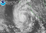
Hurricane Dora was the strongest storm of the season, reaching Category 4 intensity, and was also the first storm in 5 years to affect all three basins of the Pacific Ocean (eastern, central, and western).A tropical wave
Tropical wave
Tropical waves, easterly waves, or tropical easterly waves, also known as African easterly waves in the Atlantic region, are a type of atmospheric trough, an elongated area of relatively low air pressure, oriented north to south, which move from east to west across the tropics causing areas of...
moved off Africa
Africa
Africa is the world's second largest and second most populous continent, after Asia. At about 30.2 million km² including adjacent islands, it covers 6% of the Earth's total surface area and 20.4% of the total land area...
on July 23 and crossed the Atlantic Ocean
Atlantic Ocean
The Atlantic Ocean is the second-largest of the world's oceanic divisions. With a total area of about , it covers approximately 20% of the Earth's surface and about 26% of its water surface area...
without development. However, the wave quickly increased in organization after crossing Central America
Central America
Central America is the central geographic region of the Americas. It is the southernmost, isthmian portion of the North American continent, which connects with South America on the southeast. When considered part of the unified continental model, it is considered a subcontinent...
on August 4, and was designated Tropical Depression Seven-E on August 6. The depression strengthened into Tropical Storm Dora later that day. Dora continued to intensify despite upper-level wind shear, and became a hurricane on August 8. Shortly after, the hurricane moved westward into a more favorable environment and began to intensify more quickly, reaching Category 4 strength on August 10. It maintained that intensity for three days as it moved almost due west. Dora then weakened to Category 1 strength as it entered the area of responsibility of the Central Pacific Hurricane Center
Central Pacific Hurricane Center
The Central Pacific Hurricane Center of the United States National Weather Service is the official body responsible for tracking and issuing tropical cyclone warnings, watches, advisories, discussions, and statements for the Central North Pacific Basin...
on August 14, but restrengthened into a major hurricane as it passed south of Hawaii
Hawaii
Hawaii is the newest of the 50 U.S. states , and is the only U.S. state made up entirely of islands. It is the northernmost island group in Polynesia, occupying most of an archipelago in the central Pacific Ocean, southwest of the continental United States, southeast of Japan, and northeast of...
on August 16. Dora then began weakening for the final time as it passed south of Johnston Atoll
Johnston Atoll
Johnston Atoll is a atoll in the North Pacific Ocean about west of Hawaii. There are four islands located on the coral reef platform, two natural islands, Johnston Island and Sand Island, which have been expanded by coral dredging, as well as North Island and East Island , an additional two...
on August 18, and crossed the International Date Line
International Date Line
The International Date Line is a generally north-south imaginary line on the surface of the Earth, passing through the middle of the Pacific Ocean, that designates the place where each calendar day begins...
on August 20 shortly before weakening to a tropical storm.
Dora caused heavy surf on the Big Island of Hawaii
Hawaii (island)
The Island of Hawaii, also called the Big Island or Hawaii Island , is a volcanic island in the North Pacific Ocean...
and Johnston Atoll, but the hurricane did not directly affect land, and no casualties were reported.
Hurricane Eugene
Like the previous storms Beatriz and Calvin, Hurricane Eugene formed from a wave that moved off the African coast, days earlier. The tropical wave crossed Central AmericaCentral America
Central America is the central geographic region of the Americas. It is the southernmost, isthmian portion of the North American continent, which connects with South America on the southeast. When considered part of the unified continental model, it is considered a subcontinent...
on July 28 and for several days, it was in the eastern Pacific Ocean
Pacific Ocean
The Pacific Ocean is the largest of the Earth's oceanic divisions. It extends from the Arctic in the north to the Southern Ocean in the south, bounded by Asia and Australia in the west, and the Americas in the east.At 165.2 million square kilometres in area, this largest division of the World...
near 120°W longitude
120th meridian west
The meridian 120° west of Greenwich is a line of longitude that extends from the North Pole across the Arctic Ocean, North America, the Pacific Ocean, the Southern Ocean, and Antarctica to the South Pole....
. On August 6, the system reached tropical depression status 850 miles (1,367.9 km) off the coast of Mexico
Mexico
The United Mexican States , commonly known as Mexico , is a federal constitutional republic in North America. It is bordered on the north by the United States; on the south and west by the Pacific Ocean; on the southeast by Guatemala, Belize, and the Caribbean Sea; and on the east by the Gulf of...
. On the same day the storm reached tropical storm status and was named Eugene. A high pressure ridge forced Eugene westward where the storm reached Category 2 status on August 9. On August 11, Eugene reached the Central Pacific
Pacific Ocean
The Pacific Ocean is the largest of the Earth's oceanic divisions. It extends from the Arctic in the north to the Southern Ocean in the south, bounded by Asia and Australia in the west, and the Americas in the east.At 165.2 million square kilometres in area, this largest division of the World...
as a Category 1 hurricane with wind speeds attaining 85 mi/h. On August 13, Eugene weakened to a tropical storm 550 miles (885.1 km) east of Hawaii
Hawaii
Hawaii is the newest of the 50 U.S. states , and is the only U.S. state made up entirely of islands. It is the northernmost island group in Polynesia, occupying most of an archipelago in the central Pacific Ocean, southwest of the continental United States, southeast of Japan, and northeast of...
and then dissipated on August 15. The storm caused no damage.
Tropical Depression Nine-E
A tropical wave moved off the African coast on July 27 and entered the Pacific on August 6. The system continued westward without development until August 11, when convection began to increase. By 1200 UTC on August 13, the National Hurricane Center began classifying the system as Tropical Depression Nine-E. Due easterly wind shear, the depression did not further intensify as it moved on a generally west-northwesterly track. By August 15, the depression had dissipated.Tropical Storm Fernanda
Fernanda formed on August 17 as a tropical depression. The storm reached a peak of 65 mi/h on August 19 before encountering cooler waters that weakened the storm. Fernanda moved westward and encountered more wind shear which caused the storm to weaken to tropical depression status. Fernanda dissipated on August 22. Because Fernanda never affected land, there were no reports of damage or deaths.Tropical Depression Eleven-E
A tropical wave entered the eastern Pacific on August 15, forming a surface low south of Mexico on August 19. The broad low pressure area moved west to northwest offshore southwest Mexico, bringing a large area of nearly tropical storm-force winds offshore the country and rainfall to western Mexico. By August 23, a well-defined center consolidated, which is when the system became a tropical depression. The depression paralleled the southern coast of Baja California, but as thunderstorm activity slowly decreased due to cool sea surface temperatures, the surface low dropped southwest as it was steered by the low-level wind field of a high pressure system to its northwest before dissipating. The highest rainfall total reported from Mexico was 8.27 inches (210.1 mm) at San Felipe/Los Cabos.Hurricane Greg
Greg formed from a tropical depression on September 5. The developing storm moved northwest, close to the Mexican coast before reaching tropical storm strength on September 6. On the same day, Greg reached hurricane strength as the storm neared the Baja California PeninsulaBaja California Peninsula
The Baja California peninsula , is a peninsula in northwestern Mexico. Its land mass separates the Pacific Ocean from the Gulf of California. The Peninsula extends from Mexicali, Baja California in the north to Cabo San Lucas, Baja California Sur in the south.The total area of the Baja California...
coast. Later on September 7, the storm encountered wind shear which weakened the storm and later, Hurricane Greg made landfall in Baja California Sur
Baja California Sur
Baja California Sur , is one of the 31 states which, with the Federal District, comprise the 32 Federal Entities of Mexico. Before becoming a state on October 8, 1974, the area was known as the South Territory of Baja California. It has an area of , or 3.57% of the land mass of Mexico and comprises...
as a tropical storm, triggering widespread flooding that killed ten people.
Hurricane Hilary
A tropical wave moved off the coast of western AfricaAfrica
Africa is the world's second largest and second most populous continent, after Asia. At about 30.2 million km² including adjacent islands, it covers 6% of the Earth's total surface area and 20.4% of the total land area...
into the Atlantic Ocean
Atlantic Ocean
The Atlantic Ocean is the second-largest of the world's oceanic divisions. With a total area of about , it covers approximately 20% of the Earth's surface and about 26% of its water surface area...
on August 29, and continued to move westward through the tropical waters of the Atlantic into the Caribbean. It still remained a tropical wave as it moved over Central America
Central America
Central America is the central geographic region of the Americas. It is the southernmost, isthmian portion of the North American continent, which connects with South America on the southeast. When considered part of the unified continental model, it is considered a subcontinent...
and began to gather more convection and organization, from September 10 through September 11. Visible satellite imagery showed low level circulation and more organized deep convection as it became a tropical depression on September 17, 475 mi (764.4 km) south-southeast of the southern tip of the Baja California Peninsula
Baja California Peninsula
The Baja California peninsula , is a peninsula in northwestern Mexico. Its land mass separates the Pacific Ocean from the Gulf of California. The Peninsula extends from Mexicali, Baja California in the north to Cabo San Lucas, Baja California Sur in the south.The total area of the Baja California...
. The system reached tropical storm strength and was named Hilary, the eighth named storm of the 1999 Pacific hurricane season. It became a 75 mi/h hurricane on September 20, 200 mi (321.9 km) southwest of the Baja California Peninsula. As a hurricane, Hilary developed a banding-type eye before weakening back into a tropical storm on September 20, the same day it became a hurricane. Hilary dissipated the next day into a swirl of low-level clouds, as it bypassed Baja California
Baja California
Baja California officially Estado Libre y Soberano de Baja California is one of the 31 states which, with the Federal District, comprise the 32 Federal Entities of Mexico. It is both the northernmost and westernmost state of Mexico. Before becoming a state in 1953, the area was known as the North...
on September 21. There were no known reports of injuries or deaths from the storm.
Tropical Storm Irwin
The final storm of the 1999 Pacific hurricane season formed on October 8. The developing storm moved northwest where it became Tropical Storm Irwin on the same day. Irwin came within 75 mi (120.7 km) of the Mexican coastline before being sheared apart on October 10. Irwin dissipated the next day, 350 mi (563.3 km) south of Cabo San LucasCabo San Lucas
Cabo San Lucas , commonly called Cabo, is a city at the southern tip of the Baja California peninsula, in the municipality of Los Cabos in the Mexican state of Baja California Sur. As of the 2010 census, the population was 68,463 people...
, ending the 1999 Pacific hurricane season. Tropical Storm Irwin had only affected land minimally, so there were no reports of damage or fatalities.
Accumulated Cyclone Energy
| Accumulated Cyclone Energy (104kt2) | |||
|---|---|---|---|
| Name | ACE | Name | ACE |
| Dora Hurricane Dora (1999) Hurricane Dora was the longest-lasting tropical cyclone of the 1999 Pacific hurricane season. The fourth named storm, third hurricane, and second major hurricane of the season, Dora developed on August 6 from a tropical wave to the south of Mexico... |
27.7 (13.7) | Hilary | 3.27 |
| Beatriz | 17.3 | Fernanda | 1.97 |
| Eugene | 9.79 (4.62) | Irwin | 1.16 |
| Adrian | 5.93 | Calvin | 0.49 |
| Greg | 3.39 | ||
| Total: 71.51 (18.32) | |||
Accumulated Cyclone Energy
Accumulated cyclone energy
Accumulated cyclone energy is a measure used by the National Oceanic and Atmospheric Administration to express the activity of individual tropical cyclones and entire tropical cyclone seasons, particularly the North Atlantic hurricane season. It uses an approximation of the energy used by a...
(ACE) is a measure of how active a hurricane season is. It is determined by taking the windspeed of all cyclones with at least gale-force winds every six hours, squaring it, and adding up the results. Numbers in parenthesis are values for the Central Pacific basin.
The total ACE of this season is 89.83. As it is below 95, this season's ACE is slightly below the statistical mean for Eastern Pacific hurricane seasons. Despite the number of storms being well-below the long term average, long-lived Hurricane Dora produced an ACE of 41.4, nearly half of the total value for the season.
Storm names
The following names were used for named storms that formed in the eastern Pacific in 1999. Names that were not assigned are marked in gray. No names were retired, so it was used again in the 2005 season2005 Pacific hurricane season
The 2005 Pacific hurricane season officially began on May 15, 2005 in the eastern Pacific and on June 1, 2005 in the central Pacific, and lasted until November 30, 2005. These dates conventionally delimit the period of each year when most tropical cyclones form in the northeastern Pacific Ocean...
. This is the same list used for the 1993 season
1993 Pacific hurricane season
The 1993 Pacific hurricane season was a very active season that officially started May 15, 1993 in the eastern Pacific, and June 1, 1993 in the central Pacific, and lasted until November 30, 1993...
.
|
|
|
No central Pacific names were used; the first name used would have been Upana.
See also
- List of Pacific hurricanes
- List of Pacific hurricane seasons
- 1999 Atlantic hurricane season1999 Atlantic hurricane seasonThe 1999 Atlantic hurricane season officially began on June 1, 1999, and lasted until November 30, 1999. These dates conventionally delimit the period of each year when most tropical cyclones form in the Atlantic basin....
- 1999 Pacific typhoon season1999 Pacific typhoon seasonThe 1999 Pacific typhoon season has no official bounds; it ran year-round in 1999, but most tropical cyclones tend to form in the northwestern Pacific Ocean between May and November...
- 1999 North Indian Ocean cyclone season1999 North Indian Ocean cyclone seasonThe 1999 North Indian Ocean cyclone season was an event in the annual cycle of tropical cyclone formation. The North Indian Ocean cyclone season has no official bounds, but cyclones tend to form between April and December, with peaks in May and November...
- South-West Indian Ocean cyclone seasons: 1998–991998–99 South-West Indian Ocean cyclone seasonThe 1998–99 South-West Indian Ocean cyclone season was an annual event of tropical cyclone formation. According to the Joint Typhoon Warning Center it started on July 1, 1998 and ended on June 30, 1999. These dates conventionally delimit the period of each year when most tropical cyclones form in...
, 1999–00 - Australian region cyclone seasons: 1998–991998–99 Australian region cyclone seasonThe 1998–99 Australian region cyclone season was an event in the ongoing cycle of tropical cyclone formation. It began on 1 November 1998 and ended on 30 April 1999...
, 1999–00 - South Pacific cyclone seasons: 1998–991998–99 South Pacific cyclone seasonThe 1998–99 South Pacific cyclone season was a near average tropical cyclone seasons, with 8 tropical cyclones occurring within the South Pacific Ocean basin between 160°E and 120°W. Despite the season starting on November 1, the first tropical system of the season did not form until December 1,...
, 1999–00