
1998 Pacific typhoon season
Encyclopedia
The 1998 Pacific typhoon season has no official bounds, but most tropical cyclones tend to form in the northwestern Pacific Ocean between May and November. These dates conventionally delimit the period of each year when most tropical cyclones form in the northwestern Pacific Ocean.
The scope of this article is limited to the Pacific Ocean, north of the equator and west of the international date line
. Storms that form east of the date line and north of the equator are called hurricanes; see 1998 Pacific hurricane season
. Tropical Storms formed in the entire west Pacific basin were assigned a name by the Joint Typhoon Warning Center
. Tropical depressions in this basin have the "W" suffix added to their number. Tropical depressions that enter or form in the Philippine area of responsibility are assigned a name by the Philippine Atmospheric, Geophysical and Astronomical Services Administration
or PAGASA. This can often result in the same storm having two names.
During the 1998 season, a total of 27 tropical depressions developed across the western Pacific basin
. Of those 27 depressions, a total of 18 strengthened into tropical storms of which 9 further intensified into typhoons. The first tropical cyclone
developed on July 6, marking the latest start to any Pacific typhoon season on record, and the last one dissipated on December 22.
on July 6. The disturbance gradually became better organized and was classified as Tropical Depression 01W at 1500 UTC
on July 7. Upon becoming a depression, it marked the latest start for a Pacific typhoon
season since reliable records began in 1959. The next day, 01W entered the Philippine Atmospheric, Geophysical and Astronomical Services Administration
(PAGASA) area of responsibility and received the local name Akang. Slowly moving towards the northwest, the depression neared Taiwan
. However, increasing vertical wind shear
caused the convection
associated with the depression to become displaced from the center of circulation
. With the center exposed, 01W weakened. At 2100 UTC on July 10, the depression made landfall
in northern Taiwan and dissipated shortly after. No known damage was caused by the depression.
, a broad area of low pressure
developed in the South China Sea
. The low slowly intensified as it moved towards the north-northeast and was declared Tropical Depression 02W early on July 8. Tropical Depression 02W slowly strengthened as northerly outflow
was constricted. By late on July 8, the depression was upgraded to a tropical storm and given the name Nichole. The storm reached its peak intensity while just offshore southern Taiwan with winds of 95 km/h (60 mph 1-minute winds) according to the Joint Typhoon Warning Center
(JTWC) and 65 km/h (40 mph 10-minute winds) with a minimum pressure of 998 hPa
(mbar
) according to the Japan Meteorological Agency
(JMA). The combination of dry air, strong wind shear, and the storm's proximity to land caused Nichole to quickly weaken to a tropical depression twelve hours after reaching its peak intensity. The exposed remnants of Nichole executed a clockwise-loop offshore Taiwan before traveling north into mainland China and dissipating. Rough seas produced by the storm caused four container ships to run aground in Taiwans' Kaohsiung Harbor, none of the crew members were injured. Heavy rains in Taiwan flooded an estimated 2500 acres (10.1 km²) of crops.
on July 22. Tracking in a gradual northwest to northeast curve, the disturbance gradually intensified and was classified as a tropical depression while located 790 km (490 mi) east-northeast of Iwo Jima
on July 25. The depression briefly intensified into a tropical storm, with a peak intensity of 85 km/h (50 mph 1-minute winds) as convection wrapped around the entire center of circulation
. However, strong wind shear quickly blew away the associated convection, causing 03W to weaken to a tropical depression. Early on July 26, 03W degenerated into an exposed low before dissipating.
disturbance in early August. Persistent convection developed around the low and early on August 2, the JTWC began issuing advisories on Tropical Depression 04W.
Storm signals were put in place in the Philippines
prior to the storm's arrival on August 3. However, Otto turned away from the country and the signals were discontinued on August 5. Typhoon Otto produced heavy rains, amounting to at least 400 mm (15.7 in) in mountainous areas of Taiwan, caused flooding which killed five people. In all, damages in Taiwan amounted to NTD
25 million ($761,000 1998 USD). After traveling through the Taiwan Straight, the typhoon stuck China, producing heavy rainfall which caused flooding in areas suffering from the worst flood in at least 45 years. Officials reported no damage or loss of life resulted from the storm in Fujian Province.
. It moved westward initially, but as the trough weakened a ridge to the east, it moved northeastward where it became a tropical storm on the 23rd. Rex slowly intensified to become a typhoon on the 26th, followed by reaching a peak of 135 mi/h winds on the 28th south of Japan. As it moved northward, it brought heavy flooding to Honshū
, Japan, amounting to 13 deaths and moderate damage from mudslides across the island. Another trough pulled the storm eastward, saving Japan from a direct hit, and Rex continued northeastward to an unusually high latitude near 50º, when it became extratropical on the 9th near the Aleutian Islands, east of the International Date Line
.
, severe damage to many homes took place. One person in the region was killed after being blown off his roof while trying to repair it and twelve homes were destroyed. Several rivers overflowed their banks after rainfall exceeding 200 mm (7.9 in) fell across Hokkaidō. Throughout Sōya Subprefecture
, agricultural and fishing industry losses amounted to 23.1 million yen ($171,213 USD). Severe flooding took place in nearby Abashiri Subprefecture
where hundreds of homes were inundated after rivers broke their banks. Over 6200 ha (15,320.5 acre) of farmland was lost. Large sections of roadways were washed away, including 14 bridges. Total losses in Abashiri reached 25 million yen ($185,296 USD), much of which was due to fishing industry damage.
Severe damage was sustained in Iwamizawa, Hokkaidō
after torrential rains triggered widespread flooding. One person was killed in the city and 29 buildings were destroyed. Agricultural losses in the area amounted to 14.9 million yen ($110,436 USD). Some of the worst floods were in Obihiro
, where nearly 230 million yen ($1.7 million USD) in agricultural losses was sustained. A third fatality from Stella took place in the area.
" sunk during the storm's onslaught, killing 70 and leaving 80 others missing and presumed dead. Vicki continued northeastward, and hit southern Japan, disrupting train and passenger service and canceling over 60 domestic flights in the country.
In all, 108 people were killed and 10 others were listed as missing. Damages from the storm amounted to $81.7 million.
developed a tropical depression on October 7. It moved westward, strengthening to a tropical storm on the 10th. The large inflow of the storm developed another tropical storm on the 10th; Tropical Storm Alex. The two moved westward, and as Zeb strengthened to a typhoon on the 11th, it absorbed the short-lived Tropical Storm Alex. It continued west-northwestward, rapidly intensifying to a 180 mi/h super typhoon on the 13th with an official minimum central pressure of 900 millibars and an unofficial minimum central pressure of 872 milibars, which would tie for the second lowest on record. Zeb maintained this intensity until hitting Luzon
in the Philippines
on the 14th. After weakening over the archipelago Zeb moved northward to hit Taiwan
as a minimal typhoon on the 15th. It maintained this intensity until hitting Japan on the 17th, after which it became extratropical on the 18th. Zeb was responsible for 99 casualties in its path.
developed within the outflow
of Typhoon Zeb. The low maintained an area of deep convection
and quickly strengthened into a tropical storm. Operationally, the system was not classified as a tropical storm until 0600 UTC on October 11.
, Faith weakened to a tropical storm on December 14 just before making landfall on eastern Vietnam
. It dissipated later that day.
In the Philippines, a total of eight people were killed and 17 others were reported as missing. Throughout the country, 51,785 people were displaced and another 20,419 were evacuated. Damages amounted to PHP 513.95 million ($13 million USD). In Vietnam, 40 people were killed and three others were left missing. A total of 602 homes were destroyed, another 16,327 were damaged, and 58,487 ha of rice fields were inundated. Damages in the country amounted to VND 204 billion ($15 million USD).
. The first storm of 1998 was named Nichole and the final one was named Gil.
(PAGASA) uses its own naming scheme for tropical cyclones within its area of responsibility. Lists are recycled every four years. This is the same list used for the 1994 season
.
The scope of this article is limited to the Pacific Ocean, north of the equator and west of the international date line
International Date Line
The International Date Line is a generally north-south imaginary line on the surface of the Earth, passing through the middle of the Pacific Ocean, that designates the place where each calendar day begins...
. Storms that form east of the date line and north of the equator are called hurricanes; see 1998 Pacific hurricane season
1998 Pacific hurricane season
The 1998 Pacific hurricane season was a moderately active Pacific hurricane season with seven tropical cyclones directly affecting land. The season officially started on May 15 in the eastern Pacific, and on June 1 in the central Pacific, and ended on November 30; these dates conventionally delimit...
. Tropical Storms formed in the entire west Pacific basin were assigned a name by the Joint Typhoon Warning Center
Joint Typhoon Warning Center
The Joint Typhoon Warning Center is a joint United States Navy – United States Air Force task force located at the Naval Maritime Forecast Center in Pearl Harbor, Hawaii...
. Tropical depressions in this basin have the "W" suffix added to their number. Tropical depressions that enter or form in the Philippine area of responsibility are assigned a name by the Philippine Atmospheric, Geophysical and Astronomical Services Administration
Philippine Atmospheric, Geophysical and Astronomical Services Administration
The Philippine Atmospheric, Geophysical and Astronomical Services Administration is a Philippine national institution dedicated to provide flood and typhoon warnings, public weather forecasts and advisories, meteorological, astronomical, climatological, and other specialized information and...
or PAGASA. This can often result in the same storm having two names.
During the 1998 season, a total of 27 tropical depressions developed across the western Pacific basin
Pacific typhoon
A typhoon is a mature tropical cyclone that develops in the northwestern part of the Pacific Ocean between 180° and 100°E. This region is referred to as the northwest Pacific basin. For organizational purposes, the northern Pacific Ocean is divided into three regions: the eastern , central , and...
. Of those 27 depressions, a total of 18 strengthened into tropical storms of which 9 further intensified into typhoons. The first tropical cyclone
Tropical cyclone
A tropical cyclone is a storm system characterized by a large low-pressure center and numerous thunderstorms that produce strong winds and heavy rain. Tropical cyclones strengthen when water evaporated from the ocean is released as the saturated air rises, resulting in condensation of water vapor...
developed on July 6, marking the latest start to any Pacific typhoon season on record, and the last one dissipated on December 22.
Tropical Depression 01W (Akang)
The first tropical depression of the season developed out of a tropical disturbance which was first noted 1,080 km (670 mi) north-northwest of PalauPalau
Palau , officially the Republic of Palau , is an island nation in the Pacific Ocean, east of the Philippines and south of Tokyo. In 1978, after three decades as being part of the United Nations trusteeship, Palau chose independence instead of becoming part of the Federated States of Micronesia, a...
on July 6. The disturbance gradually became better organized and was classified as Tropical Depression 01W at 1500 UTC
Coordinated Universal Time
Coordinated Universal Time is the primary time standard by which the world regulates clocks and time. It is one of several closely related successors to Greenwich Mean Time. Computer servers, online services and other entities that rely on having a universally accepted time use UTC for that purpose...
on July 7. Upon becoming a depression, it marked the latest start for a Pacific typhoon
Pacific typhoon
A typhoon is a mature tropical cyclone that develops in the northwestern part of the Pacific Ocean between 180° and 100°E. This region is referred to as the northwest Pacific basin. For organizational purposes, the northern Pacific Ocean is divided into three regions: the eastern , central , and...
season since reliable records began in 1959. The next day, 01W entered the Philippine Atmospheric, Geophysical and Astronomical Services Administration
Philippine Atmospheric, Geophysical and Astronomical Services Administration
The Philippine Atmospheric, Geophysical and Astronomical Services Administration is a Philippine national institution dedicated to provide flood and typhoon warnings, public weather forecasts and advisories, meteorological, astronomical, climatological, and other specialized information and...
(PAGASA) area of responsibility and received the local name Akang. Slowly moving towards the northwest, the depression neared Taiwan
Taiwan
Taiwan , also known, especially in the past, as Formosa , is the largest island of the same-named island group of East Asia in the western Pacific Ocean and located off the southeastern coast of mainland China. The island forms over 99% of the current territory of the Republic of China following...
. However, increasing vertical wind shear
Wind shear
Wind shear, sometimes referred to as windshear or wind gradient, is a difference in wind speed and direction over a relatively short distance in the atmosphere...
caused the convection
Atmospheric convection
Atmospheric convection is the result of a parcel-environment instability, or temperature difference, layer in the atmosphere. Different lapse rates within dry and moist air lead to instability. Mixing of air during the day which expands the height of the planetary boundary layer leads to...
associated with the depression to become displaced from the center of circulation
Eye (cyclone)
The eye is a region of mostly calm weather found at the center of strong tropical cyclones. The eye of a storm is a roughly circular area and typically 30–65 km in diameter. It is surrounded by the eyewall, a ring of towering thunderstorms where the second most severe weather of a cyclone...
. With the center exposed, 01W weakened. At 2100 UTC on July 10, the depression made landfall
Landfall (meteorology)
Landfall is the event of a tropical cyclone or a waterspout coming onto land after being over water. When a waterspout makes landfall it is reclassified as a tornado, which can then cause damage inland...
in northern Taiwan and dissipated shortly after. No known damage was caused by the depression.
Tropical Storm Nichole
As 01W intensified over the Philippine SeaPhilippine Sea
The Philippine Sea is a marginal sea east and north of the Philippines occupying an estimated surface area of 2 million mi² on the western part of the North Pacific Ocean...
, a broad area of low pressure
Low pressure area
A low-pressure area, or "low", is a region where the atmospheric pressure at sea level is below that of surrounding locations. Low-pressure systems form under areas of wind divergence which occur in upper levels of the troposphere. The formation process of a low-pressure area is known as...
developed in the South China Sea
South China Sea
The South China Sea is a marginal sea that is part of the Pacific Ocean, encompassing an area from the Singapore and Malacca Straits to the Strait of Taiwan of around...
. The low slowly intensified as it moved towards the north-northeast and was declared Tropical Depression 02W early on July 8. Tropical Depression 02W slowly strengthened as northerly outflow
Outflow (meteorology)
Outflow, in meteorology, is air that flows outwards from a storm system. It is associated with ridging, or anticyclonic flow. In the low levels of the troposphere, outflow radiates from thunderstorms in the form of a wedge of rain-cooled air, which is visible as a thin rope-like cloud on weather...
was constricted. By late on July 8, the depression was upgraded to a tropical storm and given the name Nichole. The storm reached its peak intensity while just offshore southern Taiwan with winds of 95 km/h (60 mph 1-minute winds) according to the Joint Typhoon Warning Center
Joint Typhoon Warning Center
The Joint Typhoon Warning Center is a joint United States Navy – United States Air Force task force located at the Naval Maritime Forecast Center in Pearl Harbor, Hawaii...
(JTWC) and 65 km/h (40 mph 10-minute winds) with a minimum pressure of 998 hPa
Pascal (unit)
The pascal is the SI derived unit of pressure, internal pressure, stress, Young's modulus and tensile strength, named after the French mathematician, physicist, inventor, writer, and philosopher Blaise Pascal. It is a measure of force per unit area, defined as one newton per square metre...
(mbar
Bar (unit)
The bar is a unit of pressure equal to 100 kilopascals, and roughly equal to the atmospheric pressure on Earth at sea level. Other units derived from the bar are the megabar , kilobar , decibar , centibar , and millibar...
) according to the Japan Meteorological Agency
Japan Meteorological Agency
The or JMA, is the Japanese government's weather service. Charged with gathering and reporting weather data and forecasts in Japan, it is a semi-autonomous part of the Ministry of Land, Infrastructure and Transport...
(JMA). The combination of dry air, strong wind shear, and the storm's proximity to land caused Nichole to quickly weaken to a tropical depression twelve hours after reaching its peak intensity. The exposed remnants of Nichole executed a clockwise-loop offshore Taiwan before traveling north into mainland China and dissipating. Rough seas produced by the storm caused four container ships to run aground in Taiwans' Kaohsiung Harbor, none of the crew members were injured. Heavy rains in Taiwan flooded an estimated 2500 acres (10.1 km²) of crops.
Tropical Storm 03W
Operationally considered to have only been a tropical depression, Tropical Storm 03W developed out of a tropical disturbance along the eastern edge of a monsoon gyreMonsoon
Monsoon is traditionally defined as a seasonal reversing wind accompanied by corresponding changes in precipitation, but is now used to describe seasonal changes in atmospheric circulation and precipitation associated with the asymmetric heating of land and sea...
on July 22. Tracking in a gradual northwest to northeast curve, the disturbance gradually intensified and was classified as a tropical depression while located 790 km (490 mi) east-northeast of Iwo Jima
Iwo Jima
Iwo Jima, officially , is an island of the Japanese Volcano Islands chain, which lie south of the Ogasawara Islands and together with them form the Ogasawara Archipelago. The island is located south of mainland Tokyo and administered as part of Ogasawara, one of eight villages of Tokyo...
on July 25. The depression briefly intensified into a tropical storm, with a peak intensity of 85 km/h (50 mph 1-minute winds) as convection wrapped around the entire center of circulation
Eye (cyclone)
The eye is a region of mostly calm weather found at the center of strong tropical cyclones. The eye of a storm is a roughly circular area and typically 30–65 km in diameter. It is surrounded by the eyewall, a ring of towering thunderstorms where the second most severe weather of a cyclone...
. However, strong wind shear quickly blew away the associated convection, causing 03W to weaken to a tropical depression. Early on July 26, 03W degenerated into an exposed low before dissipating.
Typhoon Otto (Bising)
The first typhoon of the season developed out of a tropical low from a mesoscaleMesocyclone
A mesocyclone is a vortex of air, approximately 2 to 10 miles in diameter , within a convective storm....
disturbance in early August. Persistent convection developed around the low and early on August 2, the JTWC began issuing advisories on Tropical Depression 04W.
Storm signals were put in place in the Philippines
Philippines
The Philippines , officially known as the Republic of the Philippines , is a country in Southeast Asia in the western Pacific Ocean. To its north across the Luzon Strait lies Taiwan. West across the South China Sea sits Vietnam...
prior to the storm's arrival on August 3. However, Otto turned away from the country and the signals were discontinued on August 5. Typhoon Otto produced heavy rains, amounting to at least 400 mm (15.7 in) in mountainous areas of Taiwan, caused flooding which killed five people. In all, damages in Taiwan amounted to NTD
New Taiwan dollar
The New Taiwan dollar , or simply Taiwan dollar, is the official currency of the Taiwan Area of the Republic of China since 1949, when it replaced the Old Taiwan dollar...
25 million ($761,000 1998 USD). After traveling through the Taiwan Straight, the typhoon stuck China, producing heavy rainfall which caused flooding in areas suffering from the worst flood in at least 45 years. Officials reported no damage or loss of life resulted from the storm in Fujian Province.
Typhoon Rex (Deling)
An active Tropical Upper Tropospheric Trough allowed for the development of Tropical Depression 6W on August 22, east of LuzonLuzon
Luzon is the largest island in the Philippines. It is located in the northernmost region of the archipelago, and is also the name for one of the three primary island groups in the country centered on the Island of Luzon...
. It moved westward initially, but as the trough weakened a ridge to the east, it moved northeastward where it became a tropical storm on the 23rd. Rex slowly intensified to become a typhoon on the 26th, followed by reaching a peak of 135 mi/h winds on the 28th south of Japan. As it moved northward, it brought heavy flooding to Honshū
Honshu
is the largest island of Japan. The nation's main island, it is south of Hokkaido across the Tsugaru Strait, north of Shikoku across the Inland Sea, and northeast of Kyushu across the Kanmon Strait...
, Japan, amounting to 13 deaths and moderate damage from mudslides across the island. Another trough pulled the storm eastward, saving Japan from a direct hit, and Rex continued northeastward to an unusually high latitude near 50º, when it became extratropical on the 9th near the Aleutian Islands, east of the International Date Line
International Date Line
The International Date Line is a generally north-south imaginary line on the surface of the Earth, passing through the middle of the Pacific Ocean, that designates the place where each calendar day begins...
.
Severe Tropical Storm Stella
In northern Japan, near Wakkanai, HokkaidōWakkanai, Hokkaido
is a city located in Sōya, Hokkaidō. It is the capital of Sōya Subprefecture and the northernmost city in Japan. It contains Japan's northernmost point, Cape Soya, from which the Russian island of Sakhalin can be seen....
, severe damage to many homes took place. One person in the region was killed after being blown off his roof while trying to repair it and twelve homes were destroyed. Several rivers overflowed their banks after rainfall exceeding 200 mm (7.9 in) fell across Hokkaidō. Throughout Sōya Subprefecture
Soya Subprefecture
is a subprefecture of Hokkaidō, Japan. Its population is estimated to be 77,500 as of July 31, 2004 and its area is 4,050.84 km². It is the northernmost subprefecture of Japan.Wakkanai Airport is located in Wakkanai...
, agricultural and fishing industry losses amounted to 23.1 million yen ($171,213 USD). Severe flooding took place in nearby Abashiri Subprefecture
Abashiri Subprefecture
is a subprefecture of Hokkaido, Japan. It was renamed from the earlier Abashiri Subprefecture on April 1, 2010. Abashiri Subprefecture was established in 1897.-Naming:Abashiri Prefecture was named after the subprefectural office in Abashiri...
where hundreds of homes were inundated after rivers broke their banks. Over 6200 ha (15,320.5 acre) of farmland was lost. Large sections of roadways were washed away, including 14 bridges. Total losses in Abashiri reached 25 million yen ($185,296 USD), much of which was due to fishing industry damage.
Severe damage was sustained in Iwamizawa, Hokkaidō
Iwamizawa, Hokkaido
is a city located in Sorachi Subprefecture, Hokkaidō, Japan.On March 27, 2006 the town of Kurisawa, and the village of Kita, both from Sorachi District, Sorachi Subprefecture, have merged into Iwamizawa....
after torrential rains triggered widespread flooding. One person was killed in the city and 29 buildings were destroyed. Agricultural losses in the area amounted to 14.9 million yen ($110,436 USD). Some of the worst floods were in Obihiro
Obihiro, Hokkaido
is a city located in Tokachi, Hokkaidō, Japan. Obihiro is the only city in the Tokachi area. The next most populous municipality in Tokachi is the town of Otofuke, with less than a third of Obihiro's population. The city has approximately 500 foreign residents . The city contains the headquarters...
, where nearly 230 million yen ($1.7 million USD) in agricultural losses was sustained. A third fatality from Stella took place in the area.
Typhoon Todd (Emang)
Seven people were killed by Todd in Kyushu. Damage in southern Japan amounted to 31.9 million yen ($236,436 USD).Typhoon Vicki (Gading)
100 mi/h Typhoon Vicki, while moving eastward through northern Luzon, dropped torrential rainfall, killing 9 people and affecting more than 300,000 people. The ferry "MV Princess of the OrientMV Princess of the Orient
MV Princess of the Orient was a passenger ferry owned by Sulpicio Lines that sank off Fortune Island, near Batangas City in September 1998.-The sinking:...
" sunk during the storm's onslaught, killing 70 and leaving 80 others missing and presumed dead. Vicki continued northeastward, and hit southern Japan, disrupting train and passenger service and canceling over 60 domestic flights in the country.
In all, 108 people were killed and 10 others were listed as missing. Damages from the storm amounted to $81.7 million.
Typhoon Zeb (Iliang)
The monsoon trough near GuamGuam
Guam is an organized, unincorporated territory of the United States located in the western Pacific Ocean. It is one of five U.S. territories with an established civilian government. Guam is listed as one of 16 Non-Self-Governing Territories by the Special Committee on Decolonization of the United...
developed a tropical depression on October 7. It moved westward, strengthening to a tropical storm on the 10th. The large inflow of the storm developed another tropical storm on the 10th; Tropical Storm Alex. The two moved westward, and as Zeb strengthened to a typhoon on the 11th, it absorbed the short-lived Tropical Storm Alex. It continued west-northwestward, rapidly intensifying to a 180 mi/h super typhoon on the 13th with an official minimum central pressure of 900 millibars and an unofficial minimum central pressure of 872 milibars, which would tie for the second lowest on record. Zeb maintained this intensity until hitting Luzon
Luzon
Luzon is the largest island in the Philippines. It is located in the northernmost region of the archipelago, and is also the name for one of the three primary island groups in the country centered on the Island of Luzon...
in the Philippines
Philippines
The Philippines , officially known as the Republic of the Philippines , is a country in Southeast Asia in the western Pacific Ocean. To its north across the Luzon Strait lies Taiwan. West across the South China Sea sits Vietnam...
on the 14th. After weakening over the archipelago Zeb moved northward to hit Taiwan
Taiwan
Taiwan , also known, especially in the past, as Formosa , is the largest island of the same-named island group of East Asia in the western Pacific Ocean and located off the southeastern coast of mainland China. The island forms over 99% of the current territory of the Republic of China following...
as a minimal typhoon on the 15th. It maintained this intensity until hitting Japan on the 17th, after which it became extratropical on the 18th. Zeb was responsible for 99 casualties in its path.
Tropical Storm Alex
On October 10, a small area of low pressureLow pressure area
A low-pressure area, or "low", is a region where the atmospheric pressure at sea level is below that of surrounding locations. Low-pressure systems form under areas of wind divergence which occur in upper levels of the troposphere. The formation process of a low-pressure area is known as...
developed within the outflow
Outflow (meteorology)
Outflow, in meteorology, is air that flows outwards from a storm system. It is associated with ridging, or anticyclonic flow. In the low levels of the troposphere, outflow radiates from thunderstorms in the form of a wedge of rain-cooled air, which is visible as a thin rope-like cloud on weather...
of Typhoon Zeb. The low maintained an area of deep convection
Atmospheric convection
Atmospheric convection is the result of a parcel-environment instability, or temperature difference, layer in the atmosphere. Different lapse rates within dry and moist air lead to instability. Mixing of air during the day which expands the height of the planetary boundary layer leads to...
and quickly strengthened into a tropical storm. Operationally, the system was not classified as a tropical storm until 0600 UTC on October 11.
Typhoon Babs (Loleng)
A tropical disturbance in association with the TUTT (Tropical Upper Tropospheric Trough) formed into a tropical depression on October 11 near Guam. It moved westward under the influence of the Subtropical Ridge, and became a tropical storm on the 15th. Babs slowly intensified due to little upper level outflow, but when the outflow became more pronounced, it strengthened to a typhoon on the 19th and a super typhoon with a peak of 155 mi/h winds on the 20th. Babs hit the central Philippines as a Category 4, and flooded an area just hit by another super typhoon, Zeb, only 7 days before. Babs weakened over the islands, and turned north where upper level shear caused it to dissipate on the 27th. Super Typhoon Babs caused heavy mudslides in the Philippines, resulting in 156 deaths and heavy flooding.Tropical Storm Chip-07B
Chip killed at least 17 people and caused VND 16.2 billion ($923,400 1998 USD) in Vietnam. The remnants of Chip regenerated into a tropical cyclone over the Bay of Bengal. Peaking as a strong Category 1 cyclone, 07B made landfall in Bangladesh, killing 100 people.Tropical Storm Dawn
Though a weak tropical storm, torrential rains from Dawn triggered catastrophic flooding in Vietnam, killing at least 187 people. Regarded as the worst cyclone to hit the region in three decades, 500,000 homes flooded, an additional 7,000 were destroyed and an estimated 2 million people were left homeless. Damage was estimated at VND 400 billion (US$28 million).Tropical Storm Elvis (Miding)
Elvis killed 49 people and caused $30 million in damages in Vietnam.Typhoon Faith (Norming)
Tropical Storm Faith moved westward across the northwestern Pacific. It strengthened to a typhoon just as it crossed over the Philippines, an area hit by several typhoons this season. After reaching a peak of 100 mi/h winds over the South China SeaSouth China Sea
The South China Sea is a marginal sea that is part of the Pacific Ocean, encompassing an area from the Singapore and Malacca Straits to the Strait of Taiwan of around...
, Faith weakened to a tropical storm on December 14 just before making landfall on eastern Vietnam
Vietnam
Vietnam – sometimes spelled Viet Nam , officially the Socialist Republic of Vietnam – is the easternmost country on the Indochina Peninsula in Southeast Asia. It is bordered by China to the north, Laos to the northwest, Cambodia to the southwest, and the South China Sea –...
. It dissipated later that day.
In the Philippines, a total of eight people were killed and 17 others were reported as missing. Throughout the country, 51,785 people were displaced and another 20,419 were evacuated. Damages amounted to PHP 513.95 million ($13 million USD). In Vietnam, 40 people were killed and three others were left missing. A total of 602 homes were destroyed, another 16,327 were damaged, and 58,487 ha of rice fields were inundated. Damages in the country amounted to VND 204 billion ($15 million USD).
Tropical Depression 27W
The final tropical depression of the season developed from a poorly-organized tropical disturbance on December 18 over the South China Sea. Situated within an unfavorable environment, the system struggled to maintain deep convection; however, the following day, it was classified as Tropical Depression 27W by the JTWC. Operationally, 27W was regarded as a tropical storm, with maximum winds of 75 km/h (45 mph) but in post-season analysis, the intensity was lowered to 55 km/h (35 mph).Storm names
In 1998, western North Pacific tropical cyclones were named by the Joint Typhoon Warning CenterJoint Typhoon Warning Center
The Joint Typhoon Warning Center is a joint United States Navy – United States Air Force task force located at the Naval Maritime Forecast Center in Pearl Harbor, Hawaii...
. The first storm of 1998 was named Nichole and the final one was named Gil.
|
|
|
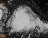
Typhoon Zeb Typhoon Zeb was a very powerful Category 5 typhoon with a minimum central pressure reading of 900 millibars and 180 mph sustained winds.... |
|
|
Philippines
The Philippine Atmospheric, Geophysical and Astronomical Services AdministrationPhilippine Atmospheric, Geophysical and Astronomical Services Administration
The Philippine Atmospheric, Geophysical and Astronomical Services Administration is a Philippine national institution dedicated to provide flood and typhoon warnings, public weather forecasts and advisories, meteorological, astronomical, climatological, and other specialized information and...
(PAGASA) uses its own naming scheme for tropical cyclones within its area of responsibility. Lists are recycled every four years. This is the same list used for the 1994 season
1994 Pacific typhoon season
The 1994 Pacific typhoon season was an active season in the annual cycle of tropical cyclone formation in the Western North Pacific, with a total of 41 tropical cyclones during the course of the season. The season had no official bounds and it ran year-round in 1994, but most tropical cyclones tend...
.
|
Typhoon Zeb Typhoon Zeb was a very powerful Category 5 typhoon with a minimum central pressure reading of 900 millibars and 180 mph sustained winds.... 18W |
|
|
|
See also
- 1998 Pacific hurricane season1998 Pacific hurricane seasonThe 1998 Pacific hurricane season was a moderately active Pacific hurricane season with seven tropical cyclones directly affecting land. The season officially started on May 15 in the eastern Pacific, and on June 1 in the central Pacific, and ended on November 30; these dates conventionally delimit...
- 1998 Atlantic hurricane season1998 Atlantic hurricane seasonThe 1998 Atlantic hurricane season officially began on June 1, 1998, and lasted until November 30, 1998. These dates conventionally delimit the period of each year when most tropical cyclones form in the Atlantic basin; however, the season extended through December 1 as Hurricane Nicole remained...
- 1998–99 Southern Hemisphere tropical cyclone season (disambiguation)
External links
- Japan Meteorological Agency
- Joint Typhoon Warning Center.
- China Meteorological Agency
- National Weather Service Guam
- Hong Kong Observatory
- Macau Meteorological Geophysical Services
- Korea Meteorological Agency
- Philippine Atmospheric, Geophysical and Astronomical Services Administration
- Taiwan Central Weather Bureau
- Satellite movie of 1998 Pacific typhoon season