
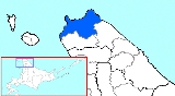
Wakkanai, Hokkaido
Encyclopedia
Cities of Japan
||A is a local administrative unit in Japan. Cities are ranked on the same level as and , with the difference that they are not a component of...
located in Sōya
Soya Subprefecture
is a subprefecture of Hokkaidō, Japan. Its population is estimated to be 77,500 as of July 31, 2004 and its area is 4,050.84 km². It is the northernmost subprefecture of Japan.Wakkanai Airport is located in Wakkanai...
, Hokkaidō
Hokkaido
, formerly known as Ezo, Yezo, Yeso, or Yesso, is Japan's second largest island; it is also the largest and northernmost of Japan's 47 prefectural-level subdivisions. The Tsugaru Strait separates Hokkaido from Honshu, although the two islands are connected by the underwater railway Seikan Tunnel...
. It is the capital of Sōya Subprefecture and the northernmost city in Japan
Japan
Japan is an island nation in East Asia. Located in the Pacific Ocean, it lies to the east of the Sea of Japan, China, North Korea, South Korea and Russia, stretching from the Sea of Okhotsk in the north to the East China Sea and Taiwan in the south...
. It contains Japan's northernmost point, Cape Soya
Cape Soya
is the northernmost point of the island of Hokkaidō, Japan. It is situated in Wakkanai, Sōya Subprefecture. The is at the cape, although the true northernmost point under Japanese control is a small deserted island called Bentenjima, 1 km northwest...
, from which the Russian island of Sakhalin
Sakhalin
Sakhalin or Saghalien, is a large island in the North Pacific, lying between 45°50' and 54°24' N.It is part of Russia, and is Russia's largest island, and is administered as part of Sakhalin Oblast...
can be seen.
As of December 31, 2007, the city has an estimated population
Population
A population is all the organisms that both belong to the same group or species and live in the same geographical area. The area that is used to define a sexual population is such that inter-breeding is possible between any pair within the area and more probable than cross-breeding with individuals...
of 40,629 and the density
Population density
Population density is a measurement of population per unit area or unit volume. It is frequently applied to living organisms, and particularly to humans...
of 53.63 persons per km². The total area is 760.80 km².
The city was founded on April 1, 1949.
Wakkanai Airport
Wakkanai Airport
is an airport located east southeast of Wakkanai, Hokkaidō, Japan.Wakkanai is the northernmost airport in Japan which is capable of handling jet aircraft; due to its small size, it is susceptible to closures during the coldest winter months, in which case incoming aircraft are often diverted to...
is located in Wakkanai, whilst the Sōya Main Line runs a diesel train from Asahikawa
Asahikawa, Hokkaido
is a city in Kamikawa Subprefecture, Hokkaido, Japan. It is the capital of the subprefecture and the second-largest city in Hokkaido, after Sapporo. It has been a Core city since April 1, 2000...
which connects to Sapporo.
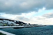
Geography
Cape SoyaCape Soya
is the northernmost point of the island of Hokkaidō, Japan. It is situated in Wakkanai, Sōya Subprefecture. The is at the cape, although the true northernmost point under Japanese control is a small deserted island called Bentenjima, 1 km northwest...
is located near Wakkanai, which is on a peninsula jutting towards Sakhalin.
- Rivers: Koetoi River
- Lakes: Ōnuma
Climate
Wakkanai has the typical humid continental climateHumid continental climate
A humid continental climate is a climatic region typified by large seasonal temperature differences, with warm to hot summers and cold winters....
(Köppen
Köppen climate classification
The Köppen climate classification is one of the most widely used climate classification systems. It was first published by Crimea German climatologist Wladimir Köppen in 1884, with several later modifications by Köppen himself, notably in 1918 and 1936...
Dfb) of Hokkaidō, with cold winters, warm summers and generally heavy precipitation from the Aleutian Low
Aleutian low
The Aleutian Low is a semi-permanent low pressure center located near the Aleutian Islands during the winter. It is one of the main centers of action in the atmospheric circulation of the Northern Hemisphere...
, whose winds hit the city direct from the Sea of Japan. The mean annual temperature, at 6.5 °C (43.7 °F), is the second lowest for a significant population centre in Japan after Nemuro
Nemuro, Hokkaido
-Transportation:Nearby Nakashibetsu Airport serves Nemuro.-Railways:*Hokkaido Railway Company – Nemuro Main Line**Stations in the city: Nemuro, Higashi-Nemuro, Hanasaki, Nishi-Wada, Kombumori, Ochiishi, Bettoga, Hattaushi, Attoko-Sightseeing:*Cape Nosappu...
. Snowfall at 257 inches (6.5 m), the second highest for a populated place in Japan after Aomori
Aomori, Aomori
is the capital city of Aomori Prefecture, in the northern Tōhoku region of Japan. As of 2009, the city had an estimated population of 302,068 and a density of 366 persons per km². Its total area was 824.52 km².- History :...
and one of the highest anywhere in the world. For comparison in Canada:
- Sept Îles receives 161 inches (4.1 m);
- Happy Valley – Goose Bay receives 181 inches (4.6 m) and
- NainNain, Newfoundland and LabradorNain or Naina is the northernmost town of any size in the Canadian province of Newfoundland and Labrador, located about 370 kilometres by air from Happy Valley-Goose Bay. The town was established as a Moravian mission in 1771 by Jens Haven and other missionaries...
receives 194 inches (4.9 m).
The Aleutian Low also makes the sunshine hours the lowest of Japan’s major population centres and in the winter the wind speeds are the highest in Japan with an average of 20.2 kilometres per hour (12.6 mph), which adds to the −4.7 C cold of a typical winter day. The city’s port is usually usable throughout the year, but does occasionally freeze in cold winters.
Surrounding municipalities
- HokkaidōHokkaido, formerly known as Ezo, Yezo, Yeso, or Yesso, is Japan's second largest island; it is also the largest and northernmost of Japan's 47 prefectural-level subdivisions. The Tsugaru Strait separates Hokkaido from Honshu, although the two islands are connected by the underwater railway Seikan Tunnel...
- ToyotomiToyotomi, Hokkaidois a town located in Teshio District, Sōya, Hokkaidō, Japan.As of 2008, the town has an estimated population of 4,663 and a density of 9.46 persons per km². The total area is 520.67 km².-External links:* in Japanese...
- SarufutsuSarufutsu, Hokkaidois a village located in Sōya District, Sōya, Hokkaidō, Japan.As of December 31, 2007, the village has an estimated population of 2,884 and a density of 4.91 persons per km². The total area is 590.00 km².-Geography:...
- Toyotomi
Outside Japan
Russian FederationRussia
Russia or , officially known as both Russia and the Russian Federation , is a country in northern Eurasia. It is a federal semi-presidential republic, comprising 83 federal subjects...
-
- KorsakovKorsakov (town)Korsakov is a town in Sakhalin Oblast, Russia. It is the administrative center of Korsakovsky District. Population: 35,079 ; The town is located some south from Yuzhno-Sakhalinsk, at the southern end of Sakhalin Island, on the coast of the Salmon Cove in the Aniva Bay.-History:Little is known...
- Yuzhno-SakhalinskYuzhno-Sakhalinsk-Demographics:Most residents are ethnic Russians, but there also exists a sizable population of Koreans. Of the 43,000 Sakhalin Koreans, half are estimated to live in Yuzhno-Sakhalinsk, comprising roughly 12% of the city's population...
PhilippinesPhilippinesThe Philippines , officially known as the Republic of the Philippines , is a country in Southeast Asia in the western Pacific Ocean. To its north across the Luzon Strait lies Taiwan. West across the South China Sea sits Vietnam... - Baguio CityBaguio CityThe City of Baguio is a highly urbanized city in northern Luzon in the Philippines. Baguio City was established by Americans in 1900 at the site of an Ibaloi village known as Kafagway...
- Korsakov