
1960 Atlantic hurricane season
Encyclopedia
The 1960 Atlantic hurricane season was the least active Atlantic hurricane season
since 1952
. The season officially began on June 15, 1960, and lasted until November 15, 1960. These dates conventionally delimit the period of each year when most tropical cyclone
s form in the Atlantic basin
. The season had below-average activity, with only seven total storms, but unfortunately, was also devastating.
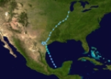
The most notable storm of the season was Hurricane Donna
, which reached Category 5 status on the Saffir–Simpson Hurricane Scale and was the longest-lasting major hurricane in the history of the Atlantic basin
. It was the worst storm to strike Florida since Hurricane King
in 1950, causing six direct deaths, and causing nearly $386.5 million in damage (1960 USD
, $ USD). Hurricane Ethel also reached Category 5 strength, but rapidly weakened prior to landfall in Mississippi
. This marks the first of only four Atlantic hurricane seasons that two or more Category 5 hurricanes were officially recorded, the other years being 1961
, 2005
and 2007
. In addition, 1960 remains the only Atlantic hurricane season with two consecutive Category 5 hurricanes.
during the season and caused 387 deaths and $396.7 million (1960 USD, $ USD) in damage.
Season activity began on June 23, with the development of an unnamed tropical storm. The season activity was confined only from June to September, and only one or two tropical cyclones developed per month in that time period. In addition, the season featured one of the least active months of August and September on record, with only two tropical cyclone developing in both months. Since the satellite era began, only The last storm of the season, Tropical Storm Florence, dissipated on September 25, over a month before the official end of the season on November 15.
on June 22. It moved northwestward, strengthening into a tropical storm the next day and hitting 30 mi (48.3 km) south of Corpus Christi, Texas
as a 45 mph (75 km/h) storm. The storm looped over southern Texas
, dumping heavy rain over the area. It moved slowly northward, and eventually dissipated over Illinois
on June 29.
The storm dropped heavy rainfall throughout much of its path, with precipitation amounts peaking at 29.76 in (755.9 mm) in Port Lavaca, Texas
. In Kentucky
, rainfall peaked at 11.25 in (285.8 mm), making it the wettest tropical cyclone in that state. Though weak, the storm caused $3.6 million in damage (1960 USD, $ USD) and 15 deaths.
on July 10, likely from a tropical wave. As it crossed the islands, it rapidly strengthened into a hurricane that night. Abby remained disorganized while crossing the Caribbean Sea
, and weakened back to a tropical storm on July 13. It became better organized while approaching the coast of British Honduras, now known as Belize
, and reached a peak of 85 mi/h before hitting the country on July 15. Abby rapidly weakened, and dissipated the next day over Mexico
. However, after the remnants of Abby entered the Pacific Ocean, and re-developed into Hurricane Celeste.
Throughout its path, Abby left light damage, totaling to $600,000 (1960 USD, $ USD) in damage, all of which was in Dominica
and St. Lucia. Abby also caused six fatalities, all on the island of St. Lucia. In addition, Abby dropped light to moderate precipitation on several of the Windward Islands
. Only minor effects were reported in Central America, limited to light winds and rain.
. Although the depression moved inland, it intensified into Tropical Storm Brenda over southeastern Georgia
on July 29. Further intensification continued, and Brenda reached its peak winds of 60 mph (95 km/h) while paralleling the eastern seaboard on July 30. It moved northward through New England
, where it became extratropical on July 31.
Brenda dropped light to relatively heavy rainfall throughout its path, peaking at 14.57 in (370.1 mm) at the Tampa International Airport
. Brenda caused an estimated $5 million (1960 USD, $ USD) in damage to western Florida
. Brenda also destroyed many trees.
as a Category 4. Donna hit the Florida Keys
, Fort Myers, Florida
, the Outer Banks
, and finally Long Island
, New York
, on September 12. Donna caused $400 million in damage (1960 dollars), and caused 364 deaths, of which 148 were directly caused by the storm.
with hurricane-force winds. Ethel made landfall as a tropical storm on the Mississippi
Gulf Coast, causing just $1 million (1960 USD) in damage.
developed into a tropical depression on September 17. It became a tropical storm the next day, but unfavorable conditions weakened Florence back to a depression. It looped over Cuba
on September 22, and moved northeastwards over Florida
. A ridge of high pressure forced Florence back westward where, after moving across the northeastern Gulf of Mexico, it dissipated over Mississippi on September 27. The only notable topic on Florence was its erratic track across the Atlantic and eastern Gulf of Mexico.
Atlantic hurricane season
The Atlantic hurricane season is the period in a year when hurricanes usually form in the Atlantic Ocean. Tropical cyclones in the North Atlantic are called hurricanes, tropical storms, or tropical depressions. In addition, there have been several storms over the years that have not been fully...
since 1952
1952 Atlantic hurricane season
The 1952 Atlantic hurricane season was the most recent season in which all named storms attained hurricane status, although it was the least active since 1946. The season officially started on June 15; however, a pre-season unnamed storm formed on Groundhog Day, becoming the only storm on...
. The season officially began on June 15, 1960, and lasted until November 15, 1960. These dates conventionally delimit the period of each year when most tropical cyclone
Tropical cyclone
A tropical cyclone is a storm system characterized by a large low-pressure center and numerous thunderstorms that produce strong winds and heavy rain. Tropical cyclones strengthen when water evaporated from the ocean is released as the saturated air rises, resulting in condensation of water vapor...
s form in the Atlantic basin
Atlantic Basin
The Atlantic Basin is the Atlantic Ocean.Atlantic Basin may also refer to:* Atlantic Basin Iron Works, an ironworks that operated in Brooklyn, New York, in the early to mid-20th century...
. The season had below-average activity, with only seven total storms, but unfortunately, was also devastating.
The most notable storm of the season was Hurricane Donna
Hurricane Donna
Hurricane Donna in the 1960 Atlantic hurricane season was a Cape Verde-type hurricane which moved across the Leeward Islands, Puerto Rico, Hispanola, Cuba, The Bahamas, and every state on the East Coast of the United States...
, which reached Category 5 status on the Saffir–Simpson Hurricane Scale and was the longest-lasting major hurricane in the history of the Atlantic basin
Atlantic Basin
The Atlantic Basin is the Atlantic Ocean.Atlantic Basin may also refer to:* Atlantic Basin Iron Works, an ironworks that operated in Brooklyn, New York, in the early to mid-20th century...
. It was the worst storm to strike Florida since Hurricane King
Hurricane King
Hurricane King was the most severe hurricane to strike Florida since the 1926 Miami hurricane. It was the eleventh tropical storm and the last of a record-setting eight major hurricanes in the 1950 Atlantic hurricane season. The cyclone formed in the western Caribbean Sea on October 13, and...
in 1950, causing six direct deaths, and causing nearly $386.5 million in damage (1960 USD
United States dollar
The United States dollar , also referred to as the American dollar, is the official currency of the United States of America. It is divided into 100 smaller units called cents or pennies....
, $ USD). Hurricane Ethel also reached Category 5 strength, but rapidly weakened prior to landfall in Mississippi
Mississippi
Mississippi is a U.S. state located in the Southern United States. Jackson is the state capital and largest city. The name of the state derives from the Mississippi River, which flows along its western boundary, whose name comes from the Ojibwe word misi-ziibi...
. This marks the first of only four Atlantic hurricane seasons that two or more Category 5 hurricanes were officially recorded, the other years being 1961
1961 Atlantic hurricane season
The 1961 Atlantic hurricane season officially began on June 15, 1961, and lasted until November 15, 1961. These dates conventionally delimit the period of each year when most tropical cyclones form in the Atlantic basin. The season had seven major hurricanes, the second highest number on...
, 2005
2005 Atlantic hurricane season
The 2005 Atlantic hurricane season was the most active Atlantic hurricane season in recorded history, repeatedly shattering numerous records. The impact of the season was widespread and ruinous with an estimated 3,913 deaths and record damage of about $159.2 billion...
and 2007
2007 Atlantic hurricane season
The 2007 Atlantic hurricane season was an active Atlantic hurricane season that produced 17 tropical cyclones, 15 tropical storms, six hurricanes, and two major hurricanes. It officially started on June 1 and ended on November 30, dates which conventionally delimit the...
. In addition, 1960 remains the only Atlantic hurricane season with two consecutive Category 5 hurricanes.
Season summary
The Atlantic hurricane season officially began on June 15, 1960. It was a below average season in which seven tropical depressions formed. All seven of the depressions attained tropical storm status, and four of these attained hurricane status. Furthermore, two storms reached major hurricane status (Category 3+ on the Saffir–Simpson Hurricane Scale); both of which became Category 5 hurricanes. Two hurricane and four tropical storms made landfallLandfall (meteorology)
Landfall is the event of a tropical cyclone or a waterspout coming onto land after being over water. When a waterspout makes landfall it is reclassified as a tornado, which can then cause damage inland...
during the season and caused 387 deaths and $396.7 million (1960 USD, $ USD) in damage.
Season activity began on June 23, with the development of an unnamed tropical storm. The season activity was confined only from June to September, and only one or two tropical cyclones developed per month in that time period. In addition, the season featured one of the least active months of August and September on record, with only two tropical cyclone developing in both months. Since the satellite era began, only The last storm of the season, Tropical Storm Florence, dissipated on September 25, over a month before the official end of the season on November 15.
Tropical Storm One
The southern portion of a strong westerly trough developed into a tropical depression in the Bay of CampecheBay of Campeche
The Bay of Campeche is the southern bight of the Gulf of Mexico. It is surrounded on three sides by the Mexican states of Campeche, Tabasco and Veracruz. It was named by Francisco Hernández de Córdoba and Antonio de Alaminos during their expedition in 1517...
on June 22. It moved northwestward, strengthening into a tropical storm the next day and hitting 30 mi (48.3 km) south of Corpus Christi, Texas
Corpus Christi, Texas
Corpus Christi is a coastal city in the South Texas region of the U.S. state of Texas. The county seat of Nueces County, it also extends into Aransas, Kleberg, and San Patricio counties. The MSA population in 2008 was 416,376. The population was 305,215 at the 2010 census making it the...
as a 45 mph (75 km/h) storm. The storm looped over southern Texas
Texas
Texas is the second largest U.S. state by both area and population, and the largest state by area in the contiguous United States.The name, based on the Caddo word "Tejas" meaning "friends" or "allies", was applied by the Spanish to the Caddo themselves and to the region of their settlement in...
, dumping heavy rain over the area. It moved slowly northward, and eventually dissipated over Illinois
Illinois
Illinois is the fifth-most populous state of the United States of America, and is often noted for being a microcosm of the entire country. With Chicago in the northeast, small industrial cities and great agricultural productivity in central and northern Illinois, and natural resources like coal,...
on June 29.
The storm dropped heavy rainfall throughout much of its path, with precipitation amounts peaking at 29.76 in (755.9 mm) in Port Lavaca, Texas
Port Lavaca, Texas
Port Lavaca is a city in Calhoun County, Texas, United States. The population was 12,248 at the 2010 census. The County had a 3.6% growth which brought the county population to 21,381. The city itself is bringing in more business into the area. It is the county seat of Calhoun County...
. In Kentucky
Kentucky
The Commonwealth of Kentucky is a state located in the East Central United States of America. As classified by the United States Census Bureau, Kentucky is a Southern state, more specifically in the East South Central region. Kentucky is one of four U.S. states constituted as a commonwealth...
, rainfall peaked at 11.25 in (285.8 mm), making it the wettest tropical cyclone in that state. Though weak, the storm caused $3.6 million in damage (1960 USD, $ USD) and 15 deaths.
Hurricane Abby
The tropical depression that became Hurricane Abby developed east of the Lesser AntillesLesser Antilles
The Lesser Antilles are a long, partly volcanic island arc in the Western Hemisphere. Most of its islands form the eastern boundary of the Caribbean Sea with the Atlantic Ocean, with the remainder located in the southern Caribbean just north of South America...
on July 10, likely from a tropical wave. As it crossed the islands, it rapidly strengthened into a hurricane that night. Abby remained disorganized while crossing the Caribbean Sea
Caribbean Sea
The Caribbean Sea is a sea of the Atlantic Ocean located in the tropics of the Western hemisphere. It is bounded by Mexico and Central America to the west and southwest, to the north by the Greater Antilles, and to the east by the Lesser Antilles....
, and weakened back to a tropical storm on July 13. It became better organized while approaching the coast of British Honduras, now known as Belize
Belize
Belize is a constitutional monarchy and the northernmost country in Central America. Belize has a diverse society, comprising many cultures and languages. Even though Kriol and Spanish are spoken among the population, Belize is the only country in Central America where English is the official...
, and reached a peak of 85 mi/h before hitting the country on July 15. Abby rapidly weakened, and dissipated the next day over Mexico
Mexico
The United Mexican States , commonly known as Mexico , is a federal constitutional republic in North America. It is bordered on the north by the United States; on the south and west by the Pacific Ocean; on the southeast by Guatemala, Belize, and the Caribbean Sea; and on the east by the Gulf of...
. However, after the remnants of Abby entered the Pacific Ocean, and re-developed into Hurricane Celeste.
Throughout its path, Abby left light damage, totaling to $600,000 (1960 USD, $ USD) in damage, all of which was in Dominica
Dominica
Dominica , officially the Commonwealth of Dominica, is an island nation in the Lesser Antilles region of the Caribbean Sea, south-southeast of Guadeloupe and northwest of Martinique. Its size is and the highest point in the country is Morne Diablotins, which has an elevation of . The Commonwealth...
and St. Lucia. Abby also caused six fatalities, all on the island of St. Lucia. In addition, Abby dropped light to moderate precipitation on several of the Windward Islands
Windward Islands
The Windward Islands are the southern islands of the Lesser Antilles, within the West Indies.-Name and geography:The Windward Islands are called such because they were more windward to sailing ships arriving in the New World than the Leeward Islands, given that the prevailing trade winds in the...
. Only minor effects were reported in Central America, limited to light winds and rain.
Tropical Storm Brenda
A weak circulation in the eastern Gulf of Mexico developed into a tropical depression on July 28. As it headed rapidly northeastward, the depression made landfall southwest of Cross City, FloridaCross City, Florida
Cross City is a town in Dixie County, Florida, United States. The population was 1,775 at the 2000 census. As of 2004, the population recorded by the U.S. Census Bureau is 1,800...
. Although the depression moved inland, it intensified into Tropical Storm Brenda over southeastern Georgia
Georgia (U.S. state)
Georgia is a state located in the southeastern United States. It was established in 1732, the last of the original Thirteen Colonies. The state is named after King George II of Great Britain. Georgia was the fourth state to ratify the United States Constitution, on January 2, 1788...
on July 29. Further intensification continued, and Brenda reached its peak winds of 60 mph (95 km/h) while paralleling the eastern seaboard on July 30. It moved northward through New England
New England
New England is a region in the northeastern corner of the United States consisting of the six states of Maine, New Hampshire, Vermont, Massachusetts, Rhode Island, and Connecticut...
, where it became extratropical on July 31.
Brenda dropped light to relatively heavy rainfall throughout its path, peaking at 14.57 in (370.1 mm) at the Tampa International Airport
Tampa International Airport
Tampa International Airport is a major public airport located six nautical miles west of the central business district of Tampa, in Hillsborough County, Florida, United States. This airport is publicly owned by Hillsborough County Aviation Authority...
. Brenda caused an estimated $5 million (1960 USD, $ USD) in damage to western Florida
Florida
Florida is a state in the southeastern United States, located on the nation's Atlantic and Gulf coasts. It is bordered to the west by the Gulf of Mexico, to the north by Alabama and Georgia and to the east by the Atlantic Ocean. With a population of 18,801,310 as measured by the 2010 census, it...
. Brenda also destroyed many trees.
Hurricane Cleo
The precursor to Hurricane Cleo was a trough of low pressure that developed into a tropical cyclone on August 17. Cleo, a small storm, became a hurricane on August 18 as it moved northeastward. After reaching a peak of 90 mi/h, cooler waters and upper-level winds weakened it steadily until its dissipation on August 21.Hurricane Donna
Hurricane Donna was the most destructive hurricane of the season. After reaching Category 5 strength in the open ocean in early September, it passed north of the Greater AntillesGreater Antilles
The Greater Antilles are one of three island groups in the Caribbean. Comprising Cuba, Jamaica, Hispaniola , and Puerto Rico, the Greater Antilles constitute almost 90% of the land mass of the entire West Indies.-Greater Antilles in context :The islands of the Caribbean Sea, collectively known as...
as a Category 4. Donna hit the Florida Keys
Florida Keys
The Florida Keys are a coral archipelago in southeast United States. They begin at the southeastern tip of the Florida peninsula, about south of Miami, and extend in a gentle arc south-southwest and then westward to Key West, the westernmost of the inhabited islands, and on to the uninhabited Dry...
, Fort Myers, Florida
Fort Myers, Florida
Fort Myers is the county seat and commercial center of Lee County, Florida, United States. Its population was 62,298 in the 2010 census, a 29.23 percent increase over the 2000 figure....
, the Outer Banks
Outer Banks
The Outer Banks is a 200-mile long string of narrow barrier islands off the coast of North Carolina, beginning in the southeastern corner of Virginia Beach on the east coast of the United States....
, and finally Long Island
Long Island
Long Island is an island located in the southeast part of the U.S. state of New York, just east of Manhattan. Stretching northeast into the Atlantic Ocean, Long Island contains four counties, two of which are boroughs of New York City , and two of which are mainly suburban...
, New York
New York
New York is a state in the Northeastern region of the United States. It is the nation's third most populous state. New York is bordered by New Jersey and Pennsylvania to the south, and by Connecticut, Massachusetts and Vermont to the east...
, on September 12. Donna caused $400 million in damage (1960 dollars), and caused 364 deaths, of which 148 were directly caused by the storm.
Hurricane Ethel
Hurricane Ethel formed in the Gulf of Mexico on September 14 and intensified rapidly, reaching Category 5 strength that evening just south of the mouth of the Mississippi River. The storm weakened to a tropical storm the next morning after brushing lower Plaquemines Parish, LouisianaPlaquemines Parish, Louisiana
Plaquemines Parish is the parish with the most combined land and water area in the U.S. state of Louisiana. The parish seat is Pointe à la Hache...
with hurricane-force winds. Ethel made landfall as a tropical storm on the Mississippi
Mississippi
Mississippi is a U.S. state located in the Southern United States. Jackson is the state capital and largest city. The name of the state derives from the Mississippi River, which flows along its western boundary, whose name comes from the Ojibwe word misi-ziibi...
Gulf Coast, causing just $1 million (1960 USD) in damage.
Tropical Storm Florence
A large area of shower activity north of Puerto RicoPuerto Rico
Puerto Rico , officially the Commonwealth of Puerto Rico , is an unincorporated territory of the United States, located in the northeastern Caribbean, east of the Dominican Republic and west of both the United States Virgin Islands and the British Virgin Islands.Puerto Rico comprises an...
developed into a tropical depression on September 17. It became a tropical storm the next day, but unfavorable conditions weakened Florence back to a depression. It looped over Cuba
Cuba
The Republic of Cuba is an island nation in the Caribbean. The nation of Cuba consists of the main island of Cuba, the Isla de la Juventud, and several archipelagos. Havana is the largest city in Cuba and the country's capital. Santiago de Cuba is the second largest city...
on September 22, and moved northeastwards over Florida
Florida
Florida is a state in the southeastern United States, located on the nation's Atlantic and Gulf coasts. It is bordered to the west by the Gulf of Mexico, to the north by Alabama and Georgia and to the east by the Atlantic Ocean. With a population of 18,801,310 as measured by the 2010 census, it...
. A ridge of high pressure forced Florence back westward where, after moving across the northeastern Gulf of Mexico, it dissipated over Mississippi on September 27. The only notable topic on Florence was its erratic track across the Atlantic and eastern Gulf of Mexico.
Storm names
The following names were used for named storms (tropical storms and hurricanes) that formed in the North Atlantic in 1960. Storms were named Abby and Donna for the first time in 1960. Names that were not assigned are marked in .
|
Retirement
The name Donna was later retired.See also
- 1960 Pacific hurricane season1960 Pacific hurricane seasonThe remnants of Hurricane Abby moved into the Eastern Pacific Ocean and intensified into a hurricane on July 20 and was named Celeste. The hurricane moved northwestward where it winds peaked at 85 mph before it weakened into a tropical storm and dissipated on July 22.-Hurricane...
- 1960 Pacific typhoon season1960 Pacific typhoon seasonThe 1960 Pacific typhoon season had no official bounds; it ran year-round in 1960, but most tropical cyclones tend to form in the northwestern Pacific Ocean between June and December...
- List of Atlantic hurricanes
- List of Atlantic hurricane seasons