
Windhoek
Encyclopedia
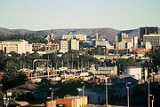
Windhoek is the capital and largest city of the Republic of Namibia
. It is located in central Namibia in the Khomas Highland plateau area, at around 1700 metres (5,577.4 ft) above sea level. The 2001 census determined Windhoek's population was 233,529. A population influx from all over Namibia has caused researchers to estimate the figure now to be well over 300,000.
Due to its relative size Windhoek is, even more than many other national capital cities, the social, economic, and cultural centre of the country. Nearly every national enterprise is headquartered here. The University of Namibia
is, too, as are the country's only theatre, all ministry head offices, and all major media and financial entities. The governmental budget of the city of Windhoek nearly equals those of all other Namibian local authorities combined.
(Otjiherero: place of steam). Both traditional names reference the hot springs near today's city centre.
Theories vary on how the place got its modern name of Windhoek. Most believe it is derived from the Afrikaans
word Wind-Hoek (wind corner). Another theory suggests that Captain Jonker Afrikaner
named Windhoek after the Winterhoek
Mountains at Tulbagh
in South Africa
, where his ancestors had lived. The first mention of the name Windhoek occurred in a letter from Jonker Afrikaner to Joseph Tindall, dated 12 August 1844.
established a settlement at Windhoek. He and his followers stayed near one of the main hot springs, located in the present-day Klein Windhoek suburb. He built a stone church that held 500 people, which was also used as a school. Two Rhenish
missionaries, Carl Hugo Hahn
and Franz Heinrich Kleinschmidt
, started working there in late 1842 and were two years later driven out by two Wesleyans, Richard Haddy and Joseph Tindall. Gardens were laid out and for a while Windhoek prospered, but wars between the Nama
and Herero eventually destroyed the settlement. After a long absence, Hahn visited Windhoek again in 1873 and was dismayed to see that nothing remained of the town's former prosperity. In June 1885, a Swiss botanist found only jackals and starving guinea fowl amongst neglected fruit trees.
annexed Walvis Bay
and incorporated it into the Cape of Good Hope
in 1884, but Britain did not extend its influence into the hinterland. A request by merchants from Lüderitzbucht
resulted in the declaration of a German
protectorate
over German South-West Africa
in 1884. The German colony came into being with the determination of its borders in 1890 and Germany sent a protective corps, called the Schutztruppe
under Major Curt von François
, to maintain order. Von François stationed his garrison at Windhoek, which was strategically situated as a buffer between the Nama
and Herero, while the twelve strong springs provided water for the cultivation of food.
Present-day Windhoek was founded on 18 October 1890, when Von François fixed the foundation stone of the fort, which is now known as the Alte Feste
(Old Fortress).
After 1907, development accelerated as people migrated from the countryside to the city. There was also a larger influx of Europe
an settlers arriving from Germany
and South Africa
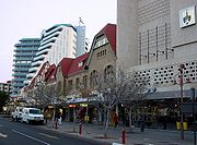
. Businesses were erected on Kaiser Street, present Independence Avenue
, and along the dominant mountain ridge over the city. At this time, Windhoek's three castles, Heinitzburg
, Sanderburg
, and Schwerinsburg
, were built.
when South Africa
n troops occupied Windhoek in May 1915 on behalf of the British Empire. For the next five years, a military government administered South West Africa. Development of the city of Windhoek and the nation later to be known as Namibia
came to a virtual standstill. After World War II, Windhoek's development gradually gained momentum, as more capital became available to improve the area's economic climate. After 1955, large public projects were undertaken, such as the building of new schools and hospitals, tarring of the city's roads (a project begun in 1928 with Kaiser Street), and the building of dams and pipelines to finally stabilize the water supply. It also introduced the World's first potable re-use plant in 1958, treating recycled sewage and sending it directly into the town's water supply.
n administration in 1990, Windhoek was recognised as the capital city of South-West Africa as administered by the South African government. It continues to be the capital city of the Republic of Namibia, as well as the provincial capital of the central Khomas Region
. Since then the city experienced accelerated growth and development.
Expanding the town area has – apart from financial restrictions – proven to be challenging due to its geographical location. In southern, eastern and western direction Windhoek is surrounded by rocky, mountainous areas which make land development costly. The southern side is not suitable for industrial development because of the presence of underground aquifers. This leaves the vast Brakwater
area north of town the only feasible place for Windhoek's expansion.
months, while nights are generally cool. The average annual temperature is 19.47 °C (67 °F), which is high for a site at such a high altitude on the edge of the tropics. This is mainly due to the prevalence of a warm northerly airflow and the mountains to the south, which shelter the city from cold southerly winds.
The winter
months of June, July and August usually experience little or no rain. Minimum temperatures range between 5 °C (41 °F) and 18 °C (64.4 °F). Nights are usually cool, although the temperature seldom drops below 0°C, and it almost never snows. Days are usually warm to hot, varying from a maximum of 20 °C (68 °F) in July to 31 °C (87.8 °F) in January.
Although the 2010/2011 rainy season brought a record of over 1000 millimetres (39.4 in), mean annual rainfall is around 360 millimetres (14.2 in), which is too low to support crops or gardens without heavy use of watering. The natural vegetation of the area is scrub and steppe. Drought
s are a regular occurrence; dry and wet years run through a cycle that lasts around 10 years.
Windhoek's population stands at over 300,000 (67% blacks, 16% whites, 17% Coloureds, Basters and Asians) and grows by over 4% annually with the informal settlements growing at almost 10% per year.
has its main office in the Trans Namib Building in Windhoek. Several shopping mall
s were built in the post-independence era, including Maerua Mall
, and Wernhil Park Mall
.
, was the first paved road in Windhoek. Ten years later the next one, Gobabis road, now Sam Nujoma Drive, was also paved. Today out of ca. 40000 kilometres (24,854.9 mi) of Namibia's total road network, about 5000 kilometres (3,106.9 mi) is sealed.
Windhoek's three main access roads from Rehoboth
, Gobabis
, and Okahandja
are paved, and are designed to be able to withstand the largest possible flood to be expected in fifty years. Sealed roads can carry traffic moving at 120 kilometres per hour (74.6 mph) and should last for 20 years.
Taxis are readily available, and are easily recognized around the city with characters consisting of one letter and as much as up to three numbers. For example (A22, T655, B3).
7 kilometres (4.3 mi) south of the city center for smaller craft, and Windhoek Hosea Kutako International Airport
42 kilometres (26.1 mi) east of the city. A number of foreign airlines operate to and from Windhoek. Air charters and helicopter and fixed-wing aircraft rentals are also available.
, situated 45 kilometres outside Windhoek, handles well over 400,000 passengers a year. It has one runway without capacity limitations. Other international airports are located in Walvis Bay and Luderitz. It directly connects daily to Frankfurt
. Southern Africa's hub, Johannesburg
, is only a two-hour flight away, from where it is possible to connect to more than 50 cities. South African Airways
, LTU
, and Air Namibia
all have daily flights to Windhoek International Airport, whilst TAAG Angola Airlines has bi-weekly turnarounds to Luanda
.
is the busiest airport in Namibia in terms of take offs and landings. This city airport handles around 12,000 individual flights a year, the majority of which are light aircraft. Primarily, limitations such as runway length, noise, and air space congestion have kept Eros from developing into a larger airport. Most of Namibia's charter operators have Eros as their base.
, Black Africa F.C., F.C. Civics Windhoek, Orlando Pirates F.C., Ramblers F.C.
and SK Windhoek
.
Many boxers such as Paulus Moses
, Paulus Ambunda
and Abmerk Shindjuu
are from the city.
The Namibia national cricket team
plays the majority of its home games at the Wanderers Cricket Ground
. It has also played at other grounds in the city, including the United Ground
and the Trans Namib Ground
.
(Saint George's College, Saint Paul's College, Windhoek International School and Windhoek Gymnasium are still attached to their respective primary schools)
Shanghai
, since 1. June 1996 Richmond
, since 20. March 1998 Wetzlar
Berlin
, since 18. April 2000 Trossingen
in Baden-Württemberg
, since 3. October 2000 Bremen
, since 18. April 2000 Douala
, since 31. August 2000 Harare
, since 8. November 2000 Gaborone
, since 23. August 2001 Havana
, since 23. October 2001 Eenhana
, since 17. April 2002 Ongwediva
, since 17. April 2002 Ondangwa, since17. April 2002 Outapi, since 17. April 2002 Oshakati
, since 18. April 2002 Lephalale
, since 22. May 2002 Vantaa
, since 13. August 2002 Walvis Bay
, since 8. October 2002 Mariental
, since 11. March 2003 Gibeon, since 11. March 2003 Maltahöhe
, since 12. April 2002 Aranos
, since 13. March 2003 Stampriet
, since 13. March 2003 Rehoboth
, since 14. March 2003 Lüderitz
, since 14. March 2003
Namibia
Namibia, officially the Republic of Namibia , is a country in southern Africa whose western border is the Atlantic Ocean. It shares land borders with Angola and Zambia to the north, Botswana to the east and South Africa to the south and east. It gained independence from South Africa on 21 March...
. It is located in central Namibia in the Khomas Highland plateau area, at around 1700 metres (5,577.4 ft) above sea level. The 2001 census determined Windhoek's population was 233,529. A population influx from all over Namibia has caused researchers to estimate the figure now to be well over 300,000.
Due to its relative size Windhoek is, even more than many other national capital cities, the social, economic, and cultural centre of the country. Nearly every national enterprise is headquartered here. The University of Namibia
University of Namibia
The University of Namibia is the national university of Namibia, located in the Pioneers Park district of Windhoek. Established by an act of National Assembly on 31 August 1992, UNAM includes Colleges of Agriculture and Natural Resources, Economics & Management Science Education, Humanities and...
is, too, as are the country's only theatre, all ministry head offices, and all major media and financial entities. The governmental budget of the city of Windhoek nearly equals those of all other Namibian local authorities combined.
Etymology
The City of Windhoek is traditionally known by two names: ǀAiǁGams, (Khoekhoe: hot springs) and OtjomuiseOtjomuise
Otjomuise is a township in north-western Windhoek, Namibia.Otjomuise is also one of the two traditional names of the town Windhoek. It references the hot springs near today's city centre...
(Otjiherero: place of steam). Both traditional names reference the hot springs near today's city centre.
Theories vary on how the place got its modern name of Windhoek. Most believe it is derived from the Afrikaans
Afrikaans
Afrikaans is a West Germanic language, spoken natively in South Africa and Namibia. It is a daughter language of Dutch, originating in its 17th century dialects, collectively referred to as Cape Dutch .Afrikaans is a daughter language of Dutch; see , , , , , .Afrikaans was historically called Cape...
word Wind-Hoek (wind corner). Another theory suggests that Captain Jonker Afrikaner
Jonker Afrikaner
Jonker Afrikaner was the fourth Captain of the Orlam Afrikaners in South West Africa, succeeding his father, Jager Afrikaner, in 1823...
named Windhoek after the Winterhoek
Winterhoek
The Winterhoekberge are located in the Western Cape province of South Africa and are part of the Cape Fold Belt. They rise to a maximum height of 2077m just north of the town of Tulbagh as Grootwinterhoekpiek...
Mountains at Tulbagh
Tulbagh
Tulbagh is a town in the Tulbagh valley and is situated in the Witzenberg Local Municipality, with the valley called "Die Land van Waveren" locally. Closest towns are Wolseley, Prince Alfred's Hamlet, Gouda and Ceres in the Boland district of the Western Cape Province, South Africa.The valley has...
in South Africa
South Africa
The Republic of South Africa is a country in southern Africa. Located at the southern tip of Africa, it is divided into nine provinces, with of coastline on the Atlantic and Indian oceans...
, where his ancestors had lived. The first mention of the name Windhoek occurred in a letter from Jonker Afrikaner to Joseph Tindall, dated 12 August 1844.
Pre-colonial
Around 1840, Jonker AfrikanerJonker Afrikaner
Jonker Afrikaner was the fourth Captain of the Orlam Afrikaners in South West Africa, succeeding his father, Jager Afrikaner, in 1823...
established a settlement at Windhoek. He and his followers stayed near one of the main hot springs, located in the present-day Klein Windhoek suburb. He built a stone church that held 500 people, which was also used as a school. Two Rhenish
Rhenish Missionary Society
The Rhenish Missionary Society was one of the largest missionary societies in Germany. Formed from smaller missions founded as far back as 1799, the Society was amalgamated on 23 September 1828, and its first missionaries were ordained and sent off to South Africa by the end of the year.The...
missionaries, Carl Hugo Hahn
Carl Hugo Hahn
Carl Hugo Hahn was a German missionary and linguist who worked in South Africa and South-West Africa for most of his life. Together with Franz Heinrich Kleinschmidt he set up the first Rhenish mission station to the Herero people in Gross Barmen...
and Franz Heinrich Kleinschmidt
Franz Heinrich Kleinschmidt
Franz Heinrich Kleinschmidt was a German missionary and linguist who worked in South-West Africa, today Namibia. He founded the missionary station and town of Rehoboth and together with Carl Hugo Hahn set up the first Rhenish mission station to the Herero people in Gross Barmen...
, started working there in late 1842 and were two years later driven out by two Wesleyans, Richard Haddy and Joseph Tindall. Gardens were laid out and for a while Windhoek prospered, but wars between the Nama
Namaqua
Nama are an African ethnic group of South Africa, Namibia and Botswana. They traditionally speak the Nama language of the Khoe-Kwadi language family, although many Nama now speak Afrikaans. The Nama are the largest group of the Khoikhoi people, most of whom have largely disappeared as a group,...
and Herero eventually destroyed the settlement. After a long absence, Hahn visited Windhoek again in 1873 and was dismayed to see that nothing remained of the town's former prosperity. In June 1885, a Swiss botanist found only jackals and starving guinea fowl amongst neglected fruit trees.
Colonial era
In 1878, BritainUnited Kingdom
The United Kingdom of Great Britain and Northern IrelandIn the United Kingdom and Dependencies, other languages have been officially recognised as legitimate autochthonous languages under the European Charter for Regional or Minority Languages...
annexed Walvis Bay
Walvis Bay
Walvis Bay , is a city in Namibia and the name of the bay on which it lies...
and incorporated it into the Cape of Good Hope
Cape of Good Hope
The Cape of Good Hope is a rocky headland on the Atlantic coast of the Cape Peninsula, South Africa.There is a misconception that the Cape of Good Hope is the southern tip of Africa, because it was once believed to be the dividing point between the Atlantic and Indian Oceans. In fact, the...
in 1884, but Britain did not extend its influence into the hinterland. A request by merchants from Lüderitzbucht
Angra Pequena
Angra Pequena was a small coastal area in what is now known as Lüderitz, Namibia.First discovered by Europeans in 1487 by the Portuguese explorer Bartolomeu Dias. On April 10, 1883 Heinrich Vogelsang first landed at Angra Pequena...
resulted in the declaration of a German
Germany
Germany , officially the Federal Republic of Germany , is a federal parliamentary republic in Europe. The country consists of 16 states while the capital and largest city is Berlin. Germany covers an area of 357,021 km2 and has a largely temperate seasonal climate...
protectorate
Protectorate
In history, the term protectorate has two different meanings. In its earliest inception, which has been adopted by modern international law, it is an autonomous territory that is protected diplomatically or militarily against third parties by a stronger state or entity...
over German South-West Africa
German South-West Africa
German South West Africa was a colony of Germany from 1884 until 1915, when it was taken over by South Africa and administered as South West Africa, finally becoming Namibia in 1990...
in 1884. The German colony came into being with the determination of its borders in 1890 and Germany sent a protective corps, called the Schutztruppe
Schutztruppe
Schutztruppe was the African colonial armed force of Imperial Germany from the late 19th century to 1918, when Germany lost its colonies. Similar to other colonial forces, the Schutztruppe consisted of volunteer European commissioned and non-commissioned officers, medical and veterinary officers. ...
under Major Curt von François
Curt von Francois
Curt Karl Bruno von François was a military and political figure in the early days of German colonialism in Africa. He is remembered as one of the pioneers of German Southwest Africa ....
, to maintain order. Von François stationed his garrison at Windhoek, which was strategically situated as a buffer between the Nama
Namaqua
Nama are an African ethnic group of South Africa, Namibia and Botswana. They traditionally speak the Nama language of the Khoe-Kwadi language family, although many Nama now speak Afrikaans. The Nama are the largest group of the Khoikhoi people, most of whom have largely disappeared as a group,...
and Herero, while the twelve strong springs provided water for the cultivation of food.
Present-day Windhoek was founded on 18 October 1890, when Von François fixed the foundation stone of the fort, which is now known as the Alte Feste
Alte Feste
The Alte Feste is a fortress and museum in downtown Windhoek, the capital of Namibia. It was designed by Curt von François and made provision for an inner courtyard with high walls and accommodation for the troops on the inside, as well as four towers...
(Old Fortress).
After 1907, development accelerated as people migrated from the countryside to the city. There was also a larger influx of Europe
Europe
Europe is, by convention, one of the world's seven continents. Comprising the westernmost peninsula of Eurasia, Europe is generally 'divided' from Asia to its east by the watershed divides of the Ural and Caucasus Mountains, the Ural River, the Caspian and Black Seas, and the waterways connecting...
an settlers arriving from Germany
Germany
Germany , officially the Federal Republic of Germany , is a federal parliamentary republic in Europe. The country consists of 16 states while the capital and largest city is Berlin. Germany covers an area of 357,021 km2 and has a largely temperate seasonal climate...
and South Africa
South Africa
The Republic of South Africa is a country in southern Africa. Located at the southern tip of Africa, it is divided into nine provinces, with of coastline on the Atlantic and Indian oceans...
. Businesses were erected on Kaiser Street, present Independence Avenue
Independence Avenue
In Washington, D.C., Independence Avenue is a major east-west street running just south of the United States Capitol in the city's Southwest and Southeast quadrants...
, and along the dominant mountain ridge over the city. At this time, Windhoek's three castles, Heinitzburg
Heinitzburg
Heinitzburg is one of the three castles in Windhoek, Namibia. It was built in 1914 by architect Wilhelm Sander....
, Sanderburg
Sanderburg
Sanderburg is the smallest of three castles in Windhoek, Namibia. It was built between 1917 and 1919 by architect Wilhelm Sander who designed it as his own place of residence. Its architectural style combines several medieval features....
, and Schwerinsburg
Schwerinsburg
Schwerinsburg is the biggest of three castles in Windhoek, Namibia. Today is the private residence of the Italian ambassador in Namibia.-History:...
, were built.
South African administration after World War I
The German colonial era came to an end during World War IWorld War I
World War I , which was predominantly called the World War or the Great War from its occurrence until 1939, and the First World War or World War I thereafter, was a major war centred in Europe that began on 28 July 1914 and lasted until 11 November 1918...
when South Africa
South Africa
The Republic of South Africa is a country in southern Africa. Located at the southern tip of Africa, it is divided into nine provinces, with of coastline on the Atlantic and Indian oceans...
n troops occupied Windhoek in May 1915 on behalf of the British Empire. For the next five years, a military government administered South West Africa. Development of the city of Windhoek and the nation later to be known as Namibia
Namibia
Namibia, officially the Republic of Namibia , is a country in southern Africa whose western border is the Atlantic Ocean. It shares land borders with Angola and Zambia to the north, Botswana to the east and South Africa to the south and east. It gained independence from South Africa on 21 March...
came to a virtual standstill. After World War II, Windhoek's development gradually gained momentum, as more capital became available to improve the area's economic climate. After 1955, large public projects were undertaken, such as the building of new schools and hospitals, tarring of the city's roads (a project begun in 1928 with Kaiser Street), and the building of dams and pipelines to finally stabilize the water supply. It also introduced the World's first potable re-use plant in 1958, treating recycled sewage and sending it directly into the town's water supply.
Since Namibian independence
With Namibia's independence from South AfricaSouth Africa
The Republic of South Africa is a country in southern Africa. Located at the southern tip of Africa, it is divided into nine provinces, with of coastline on the Atlantic and Indian oceans...
n administration in 1990, Windhoek was recognised as the capital city of South-West Africa as administered by the South African government. It continues to be the capital city of the Republic of Namibia, as well as the provincial capital of the central Khomas Region
Khomas Region
Khomas is one of the thirteen regions of Namibia. It contains the capital city Windhoek and provides for this reason superior transportation infrastructure. It has well-developed economical, financial, and trade sectors. Khomas Region occupies 4.5% of the land area of Namibia but has the highest...
. Since then the city experienced accelerated growth and development.
Geography
The city is the major commercial and financial center of Namibia. It sits on a sloping plain on the northern side of the Khomas Hochland (Khomas Highlands) at an altitude of 1728 metres (5,669.3 ft).Expanding the town area has – apart from financial restrictions – proven to be challenging due to its geographical location. In southern, eastern and western direction Windhoek is surrounded by rocky, mountainous areas which make land development costly. The southern side is not suitable for industrial development because of the presence of underground aquifers. This leaves the vast Brakwater
Brakwater
Brakwater is a settlement 20 km north of Windhoek in the Khomas Region of Namibia. It belongs to the Windhoek Rural electoral constituency....
area north of town the only feasible place for Windhoek's expansion.
Suburbs
Windhoek is divided into different suburbs:- Academia
- Auasblick
- Avis
- Cimbebasia
- Dorado Park
- Eros
- Eros Park
- Greenwell Matongo
- Goreangab
- Hakahana
- Havanna
- Hochland ParkHochland ParkHochland Park is a residential suburb in Windhoek, the capital of Namibia. It is named after the German Khomas Hochland, the central-Namibian plateau area in which Windhoek is situated....
- KatuturaKatuturaKatutura is a township of Windhoek, Khomas Region, Namibia. Katutura was created in 1961 following the forced removal of Windhoek's black population from the Old Location, which afterwards was developed into the suburb Hochland Park. Sam Nujoma Stadium, built in 2005, is located within Katutura...
- KhomasdalKhomasdalKhomasdal is a suburb of Namibia's capital of Windhoek in the Khomas Region. Founded as Windhoek's residential area for Coloured people, Khomasdal still is primarily composed of Coloured people....
- Kleine KuppeKleine KuppeKleine Kuppe is a residential suburb situated in the south of Windhoek, the capital of Namibia. Kleine Kuppe is a middle income suburb that is bordered by the suburbs of Olympia to the north and Cimbebasia to the west...
- Klein-Windhoek
- Lafrenz Industrial Area
- Ludwigsdorf
- Luxury Hill
- Northern Industrial
- Olympia
- OtjomuiseOtjomuiseOtjomuise is a township in north-western Windhoek, Namibia.Otjomuise is also one of the two traditional names of the town Windhoek. It references the hot springs near today's city centre...
- Pioneers ParkPioneers ParkPioneers Park is a suburb in the south of Windhoek, Namibia, in the Windhoek West parliamentary consituency. It was developed in the second half of the 20th century as a white community, with the previous black residents being expelled to Katutura. The suburb is mainly residential, but also...
- Prosperita
- Rocky Crest
- Southern Industrial
- Suiderhof
- WanahedaWanahedaSamora Machel constituency is a constituency in the Khomas Region of Namibia. The constituency is located across four northern suburbs of Windhoek: Wanaheda, Greenwell Matongo, Goreangab, and part of Havana...
- Windhoek CentralWindhoek Central Business DistrictWindhoek Central Business District is the inner city area of Windhoek, capital of Namibia. It is surrounded by the suburbs of Windhoek West and Hochland Park in the west, Windhoek-North in the north, Eros, Klein-Windhoek, Luxushügel and Auasblick in the east, and Suiderhof and Southern Industrial...
- Windhoek North
- Windhoek WestWindhoek WestWindhoek West is a suburb of Windhoek, the capital of Namibia. Its population is 38,969.. The Polytechnic of Namibia is located in Windhoek-West.Electorally, Windohoek West is located in the Windhoek West constituency.-References:...
Climate
Windhoek is situated in a semi-arid climatic region. Days are mostly warm with very hot days during the summerSummer
Summer is the warmest of the four temperate seasons, between spring and autumn. At the summer solstice, the days are longest and the nights are shortest, with day-length decreasing as the season progresses after the solstice...
months, while nights are generally cool. The average annual temperature is 19.47 °C (67 °F), which is high for a site at such a high altitude on the edge of the tropics. This is mainly due to the prevalence of a warm northerly airflow and the mountains to the south, which shelter the city from cold southerly winds.
The winter
Winter
Winter is the coldest season of the year in temperate climates, between autumn and spring. At the winter solstice, the days are shortest and the nights are longest, with days lengthening as the season progresses after the solstice.-Meteorology:...
months of June, July and August usually experience little or no rain. Minimum temperatures range between 5 °C (41 °F) and 18 °C (64.4 °F). Nights are usually cool, although the temperature seldom drops below 0°C, and it almost never snows. Days are usually warm to hot, varying from a maximum of 20 °C (68 °F) in July to 31 °C (87.8 °F) in January.
Although the 2010/2011 rainy season brought a record of over 1000 millimetres (39.4 in), mean annual rainfall is around 360 millimetres (14.2 in), which is too low to support crops or gardens without heavy use of watering. The natural vegetation of the area is scrub and steppe. Drought
Drought
A drought is an extended period of months or years when a region notes a deficiency in its water supply. Generally, this occurs when a region receives consistently below average precipitation. It can have a substantial impact on the ecosystem and agriculture of the affected region...
s are a regular occurrence; dry and wet years run through a cycle that lasts around 10 years.
Demographics
In 1971, there were roughly 26,000 Whites living in Windhoek, outnumbering the Black population of 24,000 but no longer. About one third of Whites, 9,000, were Germans.Windhoek's population stands at over 300,000 (67% blacks, 16% whites, 17% Coloureds, Basters and Asians) and grows by over 4% annually with the informal settlements growing at almost 10% per year.
Economy
Air NamibiaAir Namibia
Air Namibia is the national airline of Namibia, headquartered in Windhoek. It operates scheduled domestic, regional, and international passenger and cargo services under IATA airline designator SW and ICAO airline designator NMB. Its international hub is Windhoek Hosea Kutako International Airport,...
has its main office in the Trans Namib Building in Windhoek. Several shopping mall
Shopping mall
A shopping mall, shopping centre, shopping arcade, shopping precinct or simply mall is one or more buildings forming a complex of shops representing merchandisers, with interconnecting walkways enabling visitors to easily walk from unit to unit, along with a parking area — a modern, indoor version...
s were built in the post-independence era, including Maerua Mall
Maerua Mall
The Maerua Mall is a shopping complex in Windhoek, Namibia. Expanded to more than double its original size in 2006, Maerua Mall is now the largest shopping mall in Namibia and contains a number of retail outlets, including Ackermans, @home, FNB, and Total Sports...
, and Wernhil Park Mall
Wernhil Park Mall
The Wernhil Park Mall is a mall in Windhoek, Namibia. It is named after the first names of Werner and Hildegard List, the senior stockholders of the Ohlthaver and List Group of Companies who owns the facility....
.
Notable landmarks
- Alte FesteAlte FesteThe Alte Feste is a fortress and museum in downtown Windhoek, the capital of Namibia. It was designed by Curt von François and made provision for an inner courtyard with high walls and accommodation for the troops on the inside, as well as four towers...
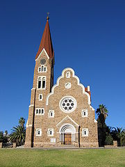
- (Old Fortress) Built in 1890, today houses the National Museum. - Christ ChurchChrist Church, WindhoekThe Christ Church is a historic landmark and Lutheran church in Windhoek, Namibia.After the end of the wars between the Germans and the Khoikhoi, Herero, and Ovambo in 1907, the ground breaking ceremony took place and on October 16, 1910 the church was opened and dedicated as the Church of Peace...
- A Lutheran church opened in 1910, built in the gothic revival style with Art NouveauArt NouveauArt Nouveau is an international philosophy and style of art, architecture and applied art—especially the decorative arts—that were most popular during 1890–1910. The name "Art Nouveau" is French for "new art"...
elements. Situated in the historic center of Windhoek next to Parliament GardensParliament GardensParliament Gardens is a small park in downtown Windhoek, Namibia. Located between the Tintenpalast and the Christuskirche, the Gardens, designed by Windhoek based landscape architect Hugo Stössel were built in 1932 and is a popular attraction for both tourists and Windhoek residents....
and TintenpalastTintenpalastThe Tintenpalast is the seat of both chambers of the Namibian legislature, the National Council and the National Assembly...
. - National Library of NamibiaNational Library of NamibiaThe National Library of Namibia is the legal deposit and copyright library for Namibia. The library is situated in Windhoek,The roots of the library are in the "Bibliothek des Kaiserlichen Gouvernements" which belonged to the government of German South-West Africa.Historical BackgroundThe library...
- St. Mary's CathedralSt. Mary's Cathedral, WindhoekSt. Mary's Cathedral, known as St. Marien Kathedrale in German, is a Roman Catholic church in Windhoek, Namibia. It is the seat of the Archdiocese of Windhoek.-External links:*...
- Supreme Court of NamibiaSupreme Court of NamibiaThe Supreme Court of Namibia is the supreme court in all matters under Namibian law. It is the court of last resort and highest appellate court in the country. It is located in the centre of the capital Windhoek.-History:...
- situated in Michael Scott Street on Eliakim Namundjebo Plaza. Built between 1994 and 1996 it is Windhoek's only building erected post-independence in an African style of architecture. - The three castles of Windhoek built by architect Wilhelm SanderWilhelm SanderWilhelm Sander was a master architect and contractor working for Sander & Kock known for his work in German South-West Africa, today's Namibia....
: HeinitzburgHeinitzburgHeinitzburg is one of the three castles in Windhoek, Namibia. It was built in 1914 by architect Wilhelm Sander....
, SanderburgSanderburgSanderburg is the smallest of three castles in Windhoek, Namibia. It was built between 1917 and 1919 by architect Wilhelm Sander who designed it as his own place of residence. Its architectural style combines several medieval features....
, and SchwerinsburgSchwerinsburgSchwerinsburg is the biggest of three castles in Windhoek, Namibia. Today is the private residence of the Italian ambassador in Namibia.-History:... - TintenpalastTintenpalastThe Tintenpalast is the seat of both chambers of the Namibian legislature, the National Council and the National Assembly...
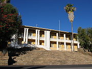
- (Ink Palace) within Parliament Gardens, the seat of both chambers of the NamibiaNamibiaNamibia, officially the Republic of Namibia , is a country in southern Africa whose western border is the Atlantic Ocean. It shares land borders with Angola and Zambia to the north, Botswana to the east and South Africa to the south and east. It gained independence from South Africa on 21 March...
n legislatureLegislatureA legislature is a kind of deliberative assembly with the power to pass, amend, and repeal laws. The law created by a legislature is called legislation or statutory law. In addition to enacting laws, legislatures usually have exclusive authority to raise or lower taxes and adopt the budget and...
. Built between 1912 and 1913 and situated just north of Robert Mugabe Avenue. - TurnhalleTurnhalle (Windhoek)The Turnhalle is a historic building in Windhoek, the capital of Namibia. Built during the era of Imperial Germany colonisation of South-West Africa, it has been through a variety of uses, most prominently as the venue for the 1975–1977 Turnhalle Constitutional Conference, a controversial attempt...
- neo-classicist building of Wilhelmine architecture, inaugurated in 1909. - Windhoek Public LibraryWindhoek Public LibraryWindhoek Public Library is a public library in downtown Windhoek, Namibia. Built in 1925, it is located next to the Alte Feste, which is home to the National Museum of Namibia. In February 2009, the library began undergoing renovations worth N$ 700,000, which included replacing the carpets with...
- built in 1925, next to the Alte Feste. - Windhoek Railway StationWindhoek Railway StationWindhoek Railway Station is a railway station in Windhoek, Namibia. It is an important station, a nodal point of the TransNamib railway. It has lines which lead eventually to Tsumeb, Oshikango, Gobabis, Keetmanshoop and Upington, South Africa....
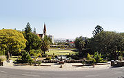
- Zoo ParkZoo ParkZoo Park is a public park on Independence Avenue in downtown Windhoek, Namibia. It is also a focal point of social life in the city The current park is landscaped and features a pond, children's playground and open-air theatre.-Pre-history:...
- a public park on Independence AvenueIndependence Avenue (Windhoek)In Windhoek, Namibia, Independence Avenue runs through the heart of downtown and is "easily explored by foot". Prior to independence, the street was known as Kaiserstrasse.-Notable buildings and parks on Independence Avenue:...
in downtown Windhoek. The current park is landscaped and features a pond, playground and open-air theatre.
Rail
Windhoek is connected by rail to:- OkahandjaOkahandjaOkahandja is a town of 14,000 inhabitants in Otjozondjupa Region, central Namibia, and the district capital of the Okahandja electoral constituency. It is known as the Garden Town of Namibia. It is located 70km north of Windhoek on the B1 road...
(north) - RehobothRehoboth, NamibiaRehoboth is a town of 21,000 inhabitants in central Namibia just north of the Tropic of Capricorn. Located on the B1 road, 90 kilometres south of the Namibian capital Windhoek, Rehoboth lies on a high elevation plateau with several natural hot-water springs. It receives sparse mean annual rainfall...
(south) - GobabisGobabisGobabis is a town in eastern Namibia. It is the regional capital of the Omaheke Region, and the district capital of the Gobabis electoral constituency. Gobabis is situated down the B6 motorway from Windhoek to Botswana. The town is from the Buitepos border post with Botswana, and serves as an...
(east)
Highways
In 1928, Kaiserstraße, now Independence AvenueIndependence Avenue (Windhoek)
In Windhoek, Namibia, Independence Avenue runs through the heart of downtown and is "easily explored by foot". Prior to independence, the street was known as Kaiserstrasse.-Notable buildings and parks on Independence Avenue:...
, was the first paved road in Windhoek. Ten years later the next one, Gobabis road, now Sam Nujoma Drive, was also paved. Today out of ca. 40000 kilometres (24,854.9 mi) of Namibia's total road network, about 5000 kilometres (3,106.9 mi) is sealed.
Windhoek's three main access roads from Rehoboth
Rehoboth, Namibia
Rehoboth is a town of 21,000 inhabitants in central Namibia just north of the Tropic of Capricorn. Located on the B1 road, 90 kilometres south of the Namibian capital Windhoek, Rehoboth lies on a high elevation plateau with several natural hot-water springs. It receives sparse mean annual rainfall...
, Gobabis
Gobabis
Gobabis is a town in eastern Namibia. It is the regional capital of the Omaheke Region, and the district capital of the Gobabis electoral constituency. Gobabis is situated down the B6 motorway from Windhoek to Botswana. The town is from the Buitepos border post with Botswana, and serves as an...
, and Okahandja
Okahandja
Okahandja is a town of 14,000 inhabitants in Otjozondjupa Region, central Namibia, and the district capital of the Okahandja electoral constituency. It is known as the Garden Town of Namibia. It is located 70km north of Windhoek on the B1 road...
are paved, and are designed to be able to withstand the largest possible flood to be expected in fifty years. Sealed roads can carry traffic moving at 120 kilometres per hour (74.6 mph) and should last for 20 years.
Taxis are readily available, and are easily recognized around the city with characters consisting of one letter and as much as up to three numbers. For example (A22, T655, B3).
Air transportation
Windhoek is served by two airports. The closest one is ErosEros Airport
Eros Airport or Windhoek Eros Airport is an airport serving Windhoek, the capital and largest city of the Republic of Namibia. It is located in the Khomas Region, about south of Windhoek's central business district....
7 kilometres (4.3 mi) south of the city center for smaller craft, and Windhoek Hosea Kutako International Airport
Windhoek Hosea Kutako International Airport
Although Hosea Kutako International Airport is the main international airport of Namibia, yet there are no direct flights from/to this airport to/from countries other than its neighbouring countries , Zimbabwe, Ghana & Germany. Therefore most of the passengers flying into / out of Namibia must have...
42 kilometres (26.1 mi) east of the city. A number of foreign airlines operate to and from Windhoek. Air charters and helicopter and fixed-wing aircraft rentals are also available.
Windhoek International Airport (WDH)
Windhoek Hosea Kutako International AirportWindhoek Hosea Kutako International Airport
Although Hosea Kutako International Airport is the main international airport of Namibia, yet there are no direct flights from/to this airport to/from countries other than its neighbouring countries , Zimbabwe, Ghana & Germany. Therefore most of the passengers flying into / out of Namibia must have...
, situated 45 kilometres outside Windhoek, handles well over 400,000 passengers a year. It has one runway without capacity limitations. Other international airports are located in Walvis Bay and Luderitz. It directly connects daily to Frankfurt
Frankfurt International Airport
Frankfurt am Main Airport , or simply Frankfurt Airport, known in German as Flughafen Frankfurt am Main or Rhein-Main-Flughafen, is a major international airport located in Frankfurt, Germany, southwest of the city centre....
. Southern Africa's hub, Johannesburg
Johannesburg
Johannesburg also known as Jozi, Jo'burg or Egoli, is the largest city in South Africa, by population. Johannesburg is the provincial capital of Gauteng, the wealthiest province in South Africa, having the largest economy of any metropolitan region in Sub-Saharan Africa...
, is only a two-hour flight away, from where it is possible to connect to more than 50 cities. South African Airways
South African Airways
South African Airways is the national flag carrier and largest airline of South Africa, with headquarters in Airways Park on the grounds of OR Tambo International Airport in Kempton Park, Ekurhuleni, Gauteng. The airline flies to 36 destinations worldwide from its hub at OR Tambo International...
, LTU
LTU International
LTU Lufttransport-Unternehmen GmbH was an airline based in Düsseldorf, Germany, now fully owned by Air Berlin. The initials stand for the German phrase LuftTransport-Unternehmen . It operated scheduled services on medium and long-haul routes, as well as charter services...
, and Air Namibia
Air Namibia
Air Namibia is the national airline of Namibia, headquartered in Windhoek. It operates scheduled domestic, regional, and international passenger and cargo services under IATA airline designator SW and ICAO airline designator NMB. Its international hub is Windhoek Hosea Kutako International Airport,...
all have daily flights to Windhoek International Airport, whilst TAAG Angola Airlines has bi-weekly turnarounds to Luanda
Luanda
Luanda, formerly named São Paulo da Assunção de Loanda, is the capital and largest city of Angola. Located on Angola's coast with the Atlantic Ocean, Luanda is both Angola's chief seaport and its administrative center. It has a population of at least 5 million...
.
Eros Airport
Eros AirportEros Airport
Eros Airport or Windhoek Eros Airport is an airport serving Windhoek, the capital and largest city of the Republic of Namibia. It is located in the Khomas Region, about south of Windhoek's central business district....
is the busiest airport in Namibia in terms of take offs and landings. This city airport handles around 12,000 individual flights a year, the majority of which are light aircraft. Primarily, limitations such as runway length, noise, and air space congestion have kept Eros from developing into a larger airport. Most of Namibia's charter operators have Eros as their base.
Sport
The city has several football clubs which include African Stars F.C.African Stars F.C.
The African Stars are a Namibian football club from Windhoek. They play in the country's highest division, the Namibia Premier League.-Achievements:*Namibia Premier League: 2*Namibian Cup: 2-Performance in CAF competitions:...
, Black Africa F.C., F.C. Civics Windhoek, Orlando Pirates F.C., Ramblers F.C.
Ramblers F.C.
The Ramblers,are a Namibian football club from Pionierspark, Windhoek.-History:They play in the country's highest division, the Namibia Premier League and the club was previously known as Windhoek Optics Ramblers....
and SK Windhoek
SK Windhoek
The Sport Klub Windhoek, also known as SK Windhoek, SKW, and Cymot SKW due to sponsorship reasons, is a Namibian sports club based in Windhoek...
.
Many boxers such as Paulus Moses
Paulus Moses
Paulus “The Hitman” Moses is a Namibian professional lightweight boxer. He was the World Boxing Association lightweight world champion...
, Paulus Ambunda
Paulus Ambunda
Paulus Ambunda is a Namibian boxer who participated in the 2004 Summer Olympics.Ambunda won the silver medal in the same division at the All-Africa Games in Abuja, Nigeria....
and Abmerk Shindjuu
Abmerk Shindjuu
Abmerk Shindjuu is a Namibian professional boxer from Windhoek. He is the Namibian flyweight champion and has fought for the Commonwealth flyweight title....
are from the city.
The Namibia national cricket team
Namibia national cricket team
The Namibia cricket team is the team that represents the country of Namibia in international cricket matches. It is governed by Cricket Namibia, an associate member of the International Cricket Council since 1992 and became part of the High Performance Program in 2007. They took part in the 2003...
plays the majority of its home games at the Wanderers Cricket Ground
Wanderers Cricket Ground, Windhoek
Wanderers Cricket Ground is a cricket ground in Windhoek, Namibia. The first recorded match on the ground was in 1990 when Namibia played the Netherlands....
. It has also played at other grounds in the city, including the United Ground
United Ground, Windhoek
United Ground is a cricket ground in Windhoek, Namibia. The first recorded match on the ground was in 1990 when Namibia played the Netherlands....
and the Trans Namib Ground
Trans Namib Ground
Trans Namib Ground is a cricket ground in Windhoek, Namibia. The first recorded match on the ground was in 1998 when a Windhoek Select XI played Denmark....
.
Tertiary Institutions
The general institutions of higher education in Windhoek are:- University of NamibiaUniversity of NamibiaThe University of Namibia is the national university of Namibia, located in the Pioneers Park district of Windhoek. Established by an act of National Assembly on 31 August 1992, UNAM includes Colleges of Agriculture and Natural Resources, Economics & Management Science Education, Humanities and...
(UNAM) - Polytechnic of NamibiaPolytechnic of NamibiaThe Polytechnic of Namibia, locally also known as Poly or Polytechnic, is an institute of tertiary education in Windhoek, Namibia. It has been established by Act 33 / 1994 of the Namibian Parliament.-History:...
(Poly) - International University of ManagementInternational University of ManagementThe International University of Management is a private, state-recognized university based in Windhoek, Namibia with campuses in Swakopmund, Walvis Bay, Ongwediva....
(IUM)
Secondary schools
- Windhoek High SchoolWindhoek High SchoolWindhoek High School is a school in Windhoek, the capital of Namibia. It is one of the oldest schools in the country.- History :With its 90-year tradition of proven academic excellence, Windhoek High School is rated as one of the top 100 schools in Namibia and ranked number 93.- Facilities :The...
(WHS) - A Shipena High School
- Delta Secondary School
- Deutsche Höhere Privatschule (DHPS)
- Eldorado Secondary School
- Immanuel Shifidi High School
- Jan Jonker Afrikaner High School
- Augustineum Secondary School
- Concordia CollegeConcordia College (Namibia)Concordia college is situated on Windhoek's Hochland Road between suburbs of Pioneers Park , Rocky Crest and Hochland Park . The school was initially privately owned by NAMDEB to provide education for their employees; this is evident on the school's diamond shaped logo...
- David Bezuidenhout Secondary School
- Ella du Plessis Secondary School
- Goreangab Secondary School
- Academia High School
- Jan Möhr High School
- Windhoek Technical High School (HTS)
- Dagbreek Centre for the handicapped
- Eros School For Girls
- Saint George's Diocesan College
- Saint Paul's CollegeSt. Paul's College, NamibiaSt. Paul's College was established in 1962 as a Catholic all boys’ school by the Tilburg Fraters. The Roman Catholic Church purchased a farm situated at the foot of Roman Hill in Klein Windhoek, a low density suburb in Windhoek, Namibia...
- Windhoek Gymnasium (WGPS)
- Windhoek International School (WIS)
- Combretum Trust School
- Windhoek Afrikaanse PrivaatskoolWindhoek Afrikaanse PrivaatskoolWindhoek Afrikaanse Privaatskool, commonly referred to as WAP, is a private school in Windhoek, Namibia. It is the only school which educates its pupils in the Afrikaans medium. Registered since 1995 at the Namibian Ministry of Basic Education, Sport and Culture, it welcomes pupils to grades 1...
(Saint George's College, Saint Paul's College, Windhoek International School and Windhoek Gymnasium are still attached to their respective primary schools)
Cooperation agreements
Windhoek has cooperation agreements and partnerships with the following towns:Shanghai
Shanghai
Shanghai is the largest city by population in China and the largest city proper in the world. It is one of the four province-level municipalities in the People's Republic of China, with a total population of over 23 million as of 2010...
, since 1. June 1996 Richmond
Richmond, Virginia
Richmond is the capital of the Commonwealth of Virginia, in the United States. It is an independent city and not part of any county. Richmond is the center of the Richmond Metropolitan Statistical Area and the Greater Richmond area...
, since 20. March 1998 Wetzlar
Wetzlar
Wetzlar is a city in the state of Hesse, Germany. Located at 8° 30′ E, 50° 34′ N, Wetzlar straddles the river Lahn and is on the German Timber-Framework Road which passes mile upon mile of half-timbered houses. Historically, the city has acted as the hub of the Lahn-Dill-Kreis on the north edge of...
Berlin
Berlin
Berlin is the capital city of Germany and is one of the 16 states of Germany. With a population of 3.45 million people, Berlin is Germany's largest city. It is the second most populous city proper and the seventh most populous urban area in the European Union...
, since 18. April 2000 Trossingen
Trossingen
Trossingen is a town in Baden-Württemberg, Germany. It is situated in a region called Baar, between the Swabian Alb and the Black Forest. Stuttgart is about an hour away, Lake Constance about half an hour, and the source of the river Danube can be reached in about twenty minutes by car.Trossingen...
in Baden-Württemberg
Baden-Württemberg
Baden-Württemberg is one of the 16 states of Germany. Baden-Württemberg is in the southwestern part of the country to the east of the Upper Rhine, and is the third largest in both area and population of Germany's sixteen states, with an area of and 10.7 million inhabitants...
, since 3. October 2000 Bremen
Bremen
The City Municipality of Bremen is a Hanseatic city in northwestern Germany. A commercial and industrial city with a major port on the river Weser, Bremen is part of the Bremen-Oldenburg metropolitan area . Bremen is the second most populous city in North Germany and tenth in Germany.Bremen is...
, since 18. April 2000 Douala
Douala
Douala is the largest city in Cameroon and the capital of Cameroon's Littoral Province. Home to Cameroon's largest port and its major international airport, Douala International Airport, it is the commercial capital of the country...
, since 31. August 2000 Harare
Harare
Harare before 1982 known as Salisbury) is the largest city and capital of Zimbabwe. It has an estimated population of 1,600,000, with 2,800,000 in its metropolitan area . Administratively, Harare is an independent city equivalent to a province. It is Zimbabwe's largest city and its...
, since 8. November 2000 Gaborone
Gaborone
' is the capital and largest city of Botswana with a population of 191,776 based on a 2006 survey, about 10% of the total population of Botswana....
, since 23. August 2001 Havana
Havana
Havana is the capital city, province, major port, and leading commercial centre of Cuba. The city proper has a population of 2.1 million inhabitants, and it spans a total of — making it the largest city in the Caribbean region, and the most populous...
, since 23. October 2001 Eenhana
Eenhana
Eenhana is the capital town of the Ohangwena Region, northern Namibia, on the border with Angola. Before Namibian independence it was a military centre of the South African Defence Force without public infrastructure. It was proclaimed a settlement in 1992, and a town in 1999...
, since 17. April 2002 Ongwediva
Ongwediva
Ongwediva is a town in the Oshana Region in the north of Namibia. It is the district capital of the Ongwediva electoral constituency. it had 27,000 inhabitants and covered 4,102 hectares of land. Ongwediva has seven churches, two private schools and 13 government-run schools...
, since 17. April 2002 Ondangwa, since17. April 2002 Outapi, since 17. April 2002 Oshakati
Oshakati
Oshakati is a town of 30,000 inhabitants in the Oshana Region of Namibia. It is the regional capital and was officially founded in July 1966. The city was used as a base of operations by the South African Defence Force during the South African Border War and Namibian War of Independence...
, since 18. April 2002 Lephalale
Lephalale
Ellisras or Lephalale is a coal mining town in the Limpopo province of South Africa immediately north of the Waterberg Massif. The town was established as Ellisras in 1960 and named after the original farm owners, Patrick Ellis and Piet Erasmus. In 2002, Ellisras was renamed Lephalale by the...
, since 22. May 2002 Vantaa
Vantaa
Vantaa is a city and municipality in Finland. Helsinki, Vantaa, Espoo and Kauniainen make up the Helsinki Metropolitan Area.Vantaa, with its population of , is the fourth most populated city of Finland. The biggest airport in Finland, the Helsinki-Vantaa Airport, is located there...
, since 13. August 2002 Walvis Bay
Walvis Bay
Walvis Bay , is a city in Namibia and the name of the bay on which it lies...
, since 8. October 2002 Mariental
Mariental, Namibia
Mariental is a town of 10,000 inhabitants in south-central Namibia, lying on the B1 national road 145 miles north of Keetmanshoop and 170 miles southeast of Windhoek. It lies at an elevation of 3,576 feet . Mariental is connected to the TransNamib railway line from Windhoek to Keetmanshoop...
, since 11. March 2003 Gibeon, since 11. March 2003 Maltahöhe
Maltahöhe
Maltahöhe is a village in Namibia, about 110 km west of Mariental in the Hardap Region.The settlement has about 2,400 inhabitants. Maltahöhe got its name from the German Hauptmann Henning von Burgsdorf who supervised a police station of the German colonial administration there in 1895. He...
, since 12. April 2002 Aranos
Aranos
Aranos is a settlement in Hardap Region, Namibia. Since August 2010 it has town status. The place normally receives an annual average rainfall of , although in the 2010/2011 rainy season were measured.-Politics:...
, since 13. March 2003 Stampriet
Stampriet
Stampriet is a village in Hardap Region, Namibia. It is located 10 km north of Mariental.-Local authority results, 2010:In the 2010 local authority election, a total of 349 votes were cast in the village. SWAPO won with approximately 74% of the vote...
, since 13. March 2003 Rehoboth
Rehoboth, Namibia
Rehoboth is a town of 21,000 inhabitants in central Namibia just north of the Tropic of Capricorn. Located on the B1 road, 90 kilometres south of the Namibian capital Windhoek, Rehoboth lies on a high elevation plateau with several natural hot-water springs. It receives sparse mean annual rainfall...
, since 14. March 2003 Lüderitz
Lüderitz
Lüderitz is a harbour town in south-west Namibia, lying on one of the least hospitable coasts in Africa. It is a port developed around Robert Harbour and Shark Island.- Overview :...
, since 14. March 2003
External links
- WhatsonWindhoek.com Events calendar and venues in Windhoek — updated daily.
- Official homepage of the City of Windhoek - Windhuk
- Die Republikein, Namibian newspaper in Afrikaans
- Allgemeine Zeitung Namibias, Namibian newspaper in German
- The Namibian, newspaper in English
- Current Windhoek Weather and Webcams for Windhoek
- 2 WebCams showing Windhoek and weather
- Website of Friends of AvisDam (FoA)
- MSN Map