
.gif)
Whale Cove (Oregon)
Encyclopedia
 |
 |
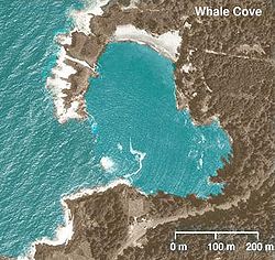
Whale Cove is a small cove
Cove
A cove is a small type of bay or coastal inlet. They usually have narrow, restricted entrances, are often circular or oval, and are often inside a larger bay. Small, narrow, sheltered bays, inlets, creeks, or recesses in a coast are often considered coves...
, approximately one-third of a mile (0.5 km) in diameter, located on the Pacific Coast
Pacific Ocean
The Pacific Ocean is the largest of the Earth's oceanic divisions. It extends from the Arctic in the north to the Southern Ocean in the south, bounded by Asia and Australia in the west, and the Americas in the east.At 165.2 million square kilometres in area, this largest division of the World...
of Oregon
Oregon
Oregon is a state in the Pacific Northwest region of the United States. It is located on the Pacific coast, with Washington to the north, California to the south, Nevada on the southeast and Idaho to the east. The Columbia and Snake rivers delineate much of Oregon's northern and eastern...
in the United States
United States
The United States of America is a federal constitutional republic comprising fifty states and a federal district...
, approximately 2 mi (3 km) south of the city of Depoe Bay
Depoe Bay, Oregon
Depoe Bay is a city in Lincoln County, Oregon, United States, located on U.S. Route 101 next to the Pacific Ocean. The population was 1,174 at the 2000 census, with an unofficial estimated population of 1,355 in 2007...
. The cove is located at approximately 44 deg 44 min N latitude.
A portion of the cove is protected as part of Rocky Creek State Park.
In 1978, British
United Kingdom
The United Kingdom of Great Britain and Northern IrelandIn the United Kingdom and Dependencies, other languages have been officially recognised as legitimate autochthonous languages under the European Charter for Regional or Minority Languages...
amateur historian
Historian
A historian is a person who studies and writes about the past and is regarded as an authority on it. Historians are concerned with the continuous, methodical narrative and research of past events as relating to the human race; as well as the study of all history in time. If the individual is...
Bob Ward proposed that Whale Cove was the location where Francis Drake
Francis Drake
Sir Francis Drake, Vice Admiral was an English sea captain, privateer, navigator, slaver, and politician of the Elizabethan era. Elizabeth I of England awarded Drake a knighthood in 1581. He was second-in-command of the English fleet against the Spanish Armada in 1588. He also carried out the...
spent the summer of 1579 during his circumnavigation
Circumnavigation
Circumnavigation – literally, "navigation of a circumference" – refers to travelling all the way around an island, a continent, or the entire planet Earth.- Global circumnavigation :...
of the globe by sea. The exact location of Drake's landing spot, at which he claimed a portion of the west coast of North America
North America
North America is a continent wholly within the Northern Hemisphere and almost wholly within the Western Hemisphere. It is also considered a northern subcontinent of the Americas...
as "New Albion
New Albion
New Albion, also known as Nova Albion, was the name of the region of the Pacific coast of North America explored by Sir Francis Drake and claimed by him for England in 1579...
", has long been a mystery. It is usually assumed to be in northern California
California
California is a state located on the West Coast of the United States. It is by far the most populous U.S. state, and the third-largest by land area...
on the coast of Marin County
Marin County, California
Marin County is a county located in the North San Francisco Bay Area of the U.S. state of California, across the Golden Gate Bridge from San Francisco. As of 2010, the population was 252,409. The county seat is San Rafael and the largest employer is the county government. Marin County is well...
.
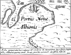
Ward proposed Whale Cove as the actual spot of Drake's landing based on its similarity to a 16th century map made by Jodocus Hondius
Jodocus Hondius
Jodocus Hondius , sometimes called Jodocus Hondius the Elder to distinguish him from his son Henricus Hondius II, was a Flemish artist, engraver, and cartographer...
. Ward theorized that Drake may have conspired with Queen Elizabeth I
Elizabeth I of England
Elizabeth I was queen regnant of England and Ireland from 17 November 1558 until her death. Sometimes called The Virgin Queen, Gloriana, or Good Queen Bess, Elizabeth was the fifth and last monarch of the Tudor dynasty...
to mislead the Spanish
Spanish Empire
The Spanish Empire comprised territories and colonies administered directly by Spain in Europe, in America, Africa, Asia and Oceania. It originated during the Age of Exploration and was therefore one of the first global empires. At the time of Habsburgs, Spain reached the peak of its world power....
about the true location of the cove to keep the Spanish from discovering Puget Sound
Puget Sound
Puget Sound is a sound in the U.S. state of Washington. It is a complex estuarine system of interconnected marine waterways and basins, with one major and one minor connection to the Strait of Juan de Fuca and the Pacific Ocean — Admiralty Inlet being the major connection and...
, which Ward believes that Drake thought was the Northwest Passage
Northwest Passage
The Northwest Passage is a sea route through the Arctic Ocean, along the northern coast of North America via waterways amidst the Canadian Arctic Archipelago, connecting the Atlantic and Pacific Oceans...
.
One longstanding puzzling feature of the Hondius map is the small island on the peninsula protecting the cove. According to Ward, a portion of the peninsula protecting Whale Cove is submerged at high tide
Tide
Tides are the rise and fall of sea levels caused by the combined effects of the gravitational forces exerted by the moon and the sun and the rotation of the Earth....
creating a similar island.
Further reading
- Samuel Bawlf, The Secret Voyage of Sir Francis Drake, Penguin Books, ISBN 0-14-200459-6