

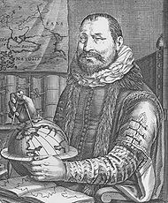
Jodocus Hondius
Encyclopedia
Dentergem
Dentergem is a municipality located in the Belgian province of West Flanders. The municipality comprises the towns of Dentergem proper, Markegem, Oeselgem and Wakken. On January 1, 2006 Dentergem had a total population of 8,188. The total area is 25.94 km² which gives a population density of 316...
— 12 February 1612, Amsterdam
Amsterdam
Amsterdam is the largest city and the capital of the Netherlands. The current position of Amsterdam as capital city of the Kingdom of the Netherlands is governed by the constitution of August 24, 1815 and its successors. Amsterdam has a population of 783,364 within city limits, an urban population...
), sometimes called Jodocus Hondius the Elder to distinguish him from his son Henricus Hondius II, was a Flemish
Flanders
Flanders is the community of the Flemings but also one of the institutions in Belgium, and a geographical region located in parts of present-day Belgium, France and the Netherlands. "Flanders" can also refer to the northern part of Belgium that contains Brussels, Bruges, Ghent and Antwerp...
artist, engraver
Engraving
Engraving is the practice of incising a design on to a hard, usually flat surface, by cutting grooves into it. The result may be a decorated object in itself, as when silver, gold, steel, or glass are engraved, or may provide an intaglio printing plate, of copper or another metal, for printing...
, and cartographer. He is best known for his early maps of the New World
New World
The New World is one of the names used for the Western Hemisphere, specifically America and sometimes Oceania . The term originated in the late 15th century, when America had been recently discovered by European explorers, expanding the geographical horizon of the people of the European middle...
and Europe
Europe
Europe is, by convention, one of the world's seven continents. Comprising the westernmost peninsula of Eurasia, Europe is generally 'divided' from Asia to its east by the watershed divides of the Ural and Caucasus Mountains, the Ural River, the Caspian and Black Seas, and the waterways connecting...
, for re-establishing the reputation of the work of Gerard Mercator, and for his portraits of Francis Drake
Francis Drake
Sir Francis Drake, Vice Admiral was an English sea captain, privateer, navigator, slaver, and politician of the Elizabethan era. Elizabeth I of England awarded Drake a knighthood in 1581. He was second-in-command of the English fleet against the Spanish Armada in 1588. He also carried out the...
. He helped establish Amsterdam
Amsterdam
Amsterdam is the largest city and the capital of the Netherlands. The current position of Amsterdam as capital city of the Kingdom of the Netherlands is governed by the constitution of August 24, 1815 and its successors. Amsterdam has a population of 783,364 within city limits, an urban population...
as the center of cartography
Cartography
Cartography is the study and practice of making maps. Combining science, aesthetics, and technique, cartography builds on the premise that reality can be modeled in ways that communicate spatial information effectively.The fundamental problems of traditional cartography are to:*Set the map's...
in Europe in the 17th century.
Biography
Hondius grew up in GhentGhent
Ghent is a city and a municipality located in the Flemish region of Belgium. It is the capital and biggest city of the East Flanders province. The city started as a settlement at the confluence of the Rivers Scheldt and Lys and in the Middle Ages became one of the largest and richest cities of...
. In his early years he established himself as an engraver
Engraving
Engraving is the practice of incising a design on to a hard, usually flat surface, by cutting grooves into it. The result may be a decorated object in itself, as when silver, gold, steel, or glass are engraved, or may provide an intaglio printing plate, of copper or another metal, for printing...
, instrument maker and globe maker. In 1584 he moved to London
London
London is the capital city of :England and the :United Kingdom, the largest metropolitan area in the United Kingdom, and the largest urban zone in the European Union by most measures. Located on the River Thames, London has been a major settlement for two millennia, its history going back to its...
to escape religious difficulties in Flanders.
Francis Drake
Sir Francis Drake, Vice Admiral was an English sea captain, privateer, navigator, slaver, and politician of the Elizabethan era. Elizabeth I of England awarded Drake a knighthood in 1581. He was second-in-command of the English fleet against the Spanish Armada in 1588. He also carried out the...
, who had made a circumnavigation
Circumnavigation
Circumnavigation – literally, "navigation of a circumference" – refers to travelling all the way around an island, a continent, or the entire planet Earth.- Global circumnavigation :...
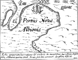
of the world in the late 1570s. In particular, in 1589 Hondius produced a now famous map of the bay of New Albion
New Albion
New Albion, also known as Nova Albion, was the name of the region of the Pacific coast of North America explored by Sir Francis Drake and claimed by him for England in 1579...
, where Drake briefly established a settlement on the west coast of North America
North America
North America is a continent wholly within the Northern Hemisphere and almost wholly within the Western Hemisphere. It is also considered a northern subcontinent of the Americas...
. Hondius' map was based on journal and eyewitness accounts of the trip and has long fueled speculation about the precise location of Drake's landing, which has not yet been firmly established by historians. Hondius is also thought to be the artist of several well-known portraits of Drake that are now in the National Portrait Gallery in London.
Between 1605 and 1610 he was employed by John Speed
John Speed
John Speed was an English historian and cartographer.-Life:He was born at Farndon, Cheshire, and went into his father's tailoring business where he worked until he was about 50...
to engrave the plates for Speed's The Theatre of the Empire of Great Britaine.
After Hondius' death in 1612, his publishing work in Amsterdam was continued by his widow and two sons, Jodocus II and Henricus. Later his family formed a partnership with Jan Jansson
Jan Janssonius
Johannes Janssonius was a Dutch cartographer who lived and worked in Amsterdam in the 17th century....
, whose name appears on the Atlas as co-publisher after 1633. Eventually, starting with the first 1606 edition in Latin, about 50 editions of the Atlas were released in the main European languages. In the Islamic world, the atlas was partially translated by the Turkish
Ottoman Empire
The Ottoman EmpireIt was usually referred to as the "Ottoman Empire", the "Turkish Empire", the "Ottoman Caliphate" or more commonly "Turkey" by its contemporaries...
scholar Katip Çelebi
Katip Çelebi
Kâtip Çelebi, Mustafa bin Abdullah, Haji Khalifa or Kalfa, was an Ottoman scholar. A historian and geographer, he is regarded as one of the most productive authors of non-religious scientific literature in the 17th century Ottoman Empire...
. The series is sometimes called the "Mercator/Hondius/Jansson" series because of Jansson's later contributions.
Links with Richard Norwood

Bermuda
Bermuda is a British overseas territory in the North Atlantic Ocean. Located off the east coast of the United States, its nearest landmass is Cape Hatteras, North Carolina, about to the west-northwest. It is about south of Halifax, Nova Scotia, Canada, and northeast of Miami, Florida...
. The ‘Sea Venture’ under Sir George Somers
George Somers
This article is about the English naval hero. For the American football player, see George Somers Admiral Sir George Somers was an English naval hero. Born in Lyme Regis, Dorset, the son of John Somers, his first fame came as part of an expedition led by Sir Amyas Preston against the Spanish...
was wrecked off Bermuda in 1609 and the surviving Englishmen divided the island into Tribes (later Parishes) and Shares, which are individually listed with their owners at the foot of the map. Shortly afterwards the Bermudas were granted to the Virginia Company
Virginia Company
The Virginia Company refers collectively to a pair of English joint stock companies chartered by James I on 10 April1606 with the purposes of establishing settlements on the coast of North America...
, hence various references to the Company on the map including the distance to the Roanoke Colony in Virginia. The miniature map with its own scale, top left, shows the island’s position relative to the Virginian coast. Hondius derived his map from Richard Norwood
Richard Norwood
Richard Norwood was an English mathematician, diver, and surveyor, connected with Isaac Newton. He has also been called "Bermuda’s outstanding genius of the seventeenth century"...
’s survey which was carried out in 1622 and published by John Speed
John Speed
John Speed was an English historian and cartographer.-Life:He was born at Farndon, Cheshire, and went into his father's tailoring business where he worked until he was about 50...
in 1627. It remains one of the most accurate and decorative maps of the period.