

New Albion
Encyclopedia
New Albion, also known as Nova Albion, was the name of the region of the Pacific coast
of North America
explored by Sir Francis Drake
and claimed by him for England
in 1579. The extent of New Albion and the location of Drake's landing have long been debated by historians, with most believing that he came ashore somewhere on the coast of northern California
.
Albion
, "the white", is an archaic name for the island of Great Britain
—a reference to the chalk cliffs lining the English Channel
in Kent
.
of the globe (1577–1580), in which he was ordered to destroy the Spanish
flotillas in the New World
and plunder settlements, Sir Francis Drake
landed on the western coast of North America
and claimed the area for Queen Elizabeth I
as New Albion. Along with Martin Frobisher
's claims in Greenland
and Baffin Island
and Drake's claims at the tip of South America
, New Albion was one of the earliest English territorial claims in the New World. However, unlike Humphrey Gilbert
's 1583 claim of Newfoundland, it was not followed up by settlements.
Assertions that he left some of his men behind as an embryo "colony" are founded merely on the reduced number who were with him in the Moluccas.
The western coast of North America
had been partially explored in 1542 by Juan Rodriguez Cabrillo
who sailed for the Spanish
, but as England
was in conflict with Spain, Drake decided to claim the region. Wherever his actual landing place was, it was well north of San Diego Bay
where Cabrillo had asserted Spain's claim. Spain had claimed the entire Pacific coast of the Americas since the Inter caetera
papal bull of 1493, reinforced in 1513 when Vasco Núñez de Balboa
formally claimed all lands adjoining the Pacific Ocean for the Spanish Crown. However, England did not recognize the authority of the Inter caetera and Balboa's claim covered a vast and mostly unknown area.
Upon his return to England on 4 April 1581, Francis Drake was knighted by the French Ambassador on behalf of Queen Elizabeth I
for his deeds against the Spanish during the circumnavigational voyage. However, in order to keep an uneasy peace with Spain, and to avoid having Spain threaten England's other claims in the New World, Drake's logs, charts, and other writings were confiscated. Thus, the discovery and claim on New Albion was ordered by the Queen to be considered a state secret. Drake and his crew were sworn to silence on pain of death. Only years later, after England's destruction of the Spanish Armada
in 1588 (in which Drake played a significant role), did Queen Elizabeth allow an official account of Drake's voyage by Richard Hakluyt
to be published — though with many of the details obscured.
However, Drake was always uneasy with the misrepresentations in the "official" account, and in 1592, he wrote to Queen Elizabeth in reference to "the certain truth concealed, as I have thought it necessary myself." and requesting that the account be rewritten accordingly. The Queen denied his request.
Drake's account of the voyage including many details of New Albion was published in 1628.
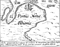 After Elizabeth's death, maps began to mark the area of North America above New Spain
and New Mexico as Nova Albion, although the boundaries and locations greatly differ among maps. However, Drake's claiming land on the Pacific coast became the legal basis for subsequent colonial charters granted by English monarchs that claimed lands from "sea to sea" (i.e. from the Atlantic where English colonies were first settled, to the Pacific). However, despite these claims, the English did not establish a colonizing presence on the west coast of North America until the late 18th century in the form of the explorations and asserted claims of Captains Cook
and Vancouver
and the associated Nootka Convention
s, shortly after, the establishment of the Columbia Fur District
of the Hudson's Bay Company
and its headquarters at Fort Vancouver
.
found at Drakes Bay
.
 The most prevalent theory has been that Drake landed in Marin County, California
, near Point Reyes
, just north of the Golden Gate
.38.034223°N 122.940800°W
Starting in the seventeenth century, maps identify Drakes Bay as Drake’s landing site.
George Vancouver
studied Drake’s landing site and concluded it was in Drakes Bay.
"Professor George Davidson
, of the United States Coast and Geodetic Survey, after a careful study of the narrative and the coast identifies the harbour entered by Drake with Drake's Bay, under Point Reyes, about thirty miles (50 km) north of San Francisco. 'Drake's Bay,' he says, 'is a capital harbor in northwest winds, such as Drake encountered. It is easily entered, sheltered bv high lands, and a vessel may anchor in three fathoms, close under the shore in good holding ground.'"
Since 1949, the theory that Drake landed at Drakes Bay has been advocated by the Drake Navigators Guild
in California, and notably by its former president Captain Adolph S. Oko, Jr., its former honorary chairman Chester W. Nimitz, and its longtime former president Raymond Aker
. Oko wrote, "Many other correlative facts have been ... found true to the Drake's Cove site as part of the total body of evidence. The weight of evidence truly establishes Drake's Cove as the nodal point of Nova Albion." Nimitz stated that he did "not doubt that in time the public will come to recognize the importance and value of this long-lost site (Drake's Cove in Drakes Bay), and will rank it with other National Historic Sites such as Roanoke
, Jamestown
, and Plymouth
."
Aker made detailed studies reconstructing Drake's circumnavigation voyage. Advocates of this theory cite the fact that the official published account placed the colony at 38 degrees north
. The geography of Drake's Cove, which lies along the coast of Marin County, has often been suggested as being similar to the cove described by Drake, including the white cliffs that look like the south coast of England and the specific configuration of the Cove. The current geographical fit is by no means complete, however, leaving open the question, even among those who support the Marin County theory, as to the location of the colony. Aker maintained that the criticisms of the cove's geography were unfounded, because the configuration of the sandbars in the cove was cyclic over the decades. He predicted that a spit of land which closely resembles one on the Hondius map that disappeared in 1956 would reappear: it formed again in 2001.
Nearly one hundred pieces of sixteenth-century Chinese porcelains have been found in the vicinity of the Drake's Cove site which “must fairly be attributed to Francis Drake’s Golden Hind visit of 1579.”
Proximate to Drake's Bay is the Coast Miwok village site of Olompali (historically spelled "Olompolli"). According to the Olompali Park website, a pierced Elizabethan silver sixpence bearing the date of 1567--the oldest artifact bearing a calendar date ever found in California--was discovered in the park by archeologists. This indicates that Olompali residents may have had contact with Sir Francis Drake or with people who had traded with the English explorer. The sixpence is now in the collection of the Bancroft Library, University of California at Berkeley, CA.
recognized a plethora of confusion from chiefly armchair historians including Samuel Johnson
and Jules Verne
.
in present-day Oregon.44.788944°N 124.070689°W Advocates of the Whale Cove theory argue that when Captain James Cook first sighted the American coast at Cape Foulweather
two centuries later, he described it in his log, with unknowing accuracy, as "the long-looked for coast of New Albion." Whale Cove lies just north of Cape Foulweather. Advocates of the Whale Cove theory dismiss the latitude given by Drake on the grounds that he may have deliberately falsified it in order to deceive the rival Spanish. Although the official account of Drake's voyage gives the anchorage location as 38 degrees
, the only two known hand-written accounts of the voyage, preserved in the British Library, say that it was at 44 degrees
, which is on the mid-Oregon coast. Drake and Queen Elizabeth, they argue, falsified the location because he mistakenly thought he had discovered the North West Passage when he found, and sailed into, the Strait of Juan de Fuca
, which today separates Vancouver Island
, British Columbia
from the mainland Olympic Peninsula
of Washington state.
Gitzen claims the “Neahkahnie Mountain Survey,” the Hondius Map, the Nehalem Indians and the Three Arch Rocks prove Drake’s landing site was in Nehalem Bay Oregon.
Gitzen argues that the “Survey” is a formal survey of the coastal area two to four miles north of Nehalem Bay encompassing the area up to one mile inland. The rocks include the “AUGUR” rock which includes “Roman numbers, Latin italics, and some, although they looked like Roman capital letters, were actually angles and bearings,” the “W” rock which has components that “represent a combination of sun and star sighting points to determine the longitude, date and time and day,” and the “Rays Rock” which “is a compass rose point used to measure points on Neahkahnie Mountain and beyond.”
Gitzen claims the outline and topography of Nehalem Bay match the Hondius Map, and that the Islands of Saint James are the Three Arch Rocks 13 miles south of the entrance to Nehalem Bay.
Gitzen does not explain why Drake would have executed this single formal survey of his voyage, and why such an extensive survey would not be in any of the thorough documentation of the visit. He claims the survey is from Drake, but does not prove the rock markings show what they are stated to contain and does not prove the age of the markings. Nehalem Bay does not match the Hondius Map’s island, peninsula shape and other characteristics. The Hondius Map indicates a bay several ship-lengths across, while Nehalem Bay is more than one mile across. While a number of Native American characteristics are common on the Pacific Coast, Gitzen does not explain why fully feathered baskets known only among the Coast Miwok of California are described in the accounts. Three Arch Rocks are small, each at three to four acres in size, located just offshore where they have long been recognized as “rocks,” not “islands:” the Farallon Islands
, in contrast, comprise 211 acres 27 miles (43 km) offshore.
and that Drake erected a post containing such a proclamation at what is today Comox, British Columbia
, located on Vancouver Island
.49.66°N 124.95°W Bawlf points to a number of pieces of evidence in support of his view that the official published record of Drake's voyage was deliberately altered to suppress the true extent of his discoveries. Bawlf also relies heavily upon the configuration of the coastline as depicted in some of the maps and globes of the era, including the so-called French and Dutch Drake Maps which depict his voyage as having reached a point northward of a chain of islands to the northwest of New Spain and other maps depicting New Albion at latitudes above those of northern California, such as Richard Hakluyt
's 1587 map of the New World showing Nova Albion at 50 degrees north latitude. Bawlf also placed emphasis on the fact that on an initial rendition of his globe in 1592 Emery Molyneux
depicted the line of the coast of North America behind Vancouver Island with remarkable accuracy, although the islands themselves, depicted on the French and Dutch Drake maps, do not appear.
Although Bob Ward initially drew some of the discrepancies between the official published accounts of Drake's voyage and other documents to Bawlf's attention, and concluded that Drake likely sailed much farther to the north than northern California, he has been critical of some of Bawlf's conclusions, such as Drake's erecting a post proclaiming New Albion at what is now Comox Bay.
Bawlf's work has also been criticized by Edward Von der Porten, President of the Drake Navigators Guild. Von der Porten calculates that Bawlf's theory requires the Golden Hinde to have traveled "an average of 5.95 knots... in a ship capable of less than one knot in those conditions." Further, Bawlf fails to identify the white cliffs, the Islands of St. James or the Coast Miwok People. Von der Porten states that Bawlf "has no evidence for either the conspiracy or his 'ten degree rule.'"
Pretty's description of some of the animals in the area as looking like strange kind of Conies with the tail of a Rat, being of great length lead to its identification as the Botta Pocket Gopher (Thomoys bottae bottae)
. The description of the Botta Pocket Gopher is important because it is known at the Drakes Bay site.
" came to public attention in 1936, it was believed that the "plate" that Pretty describes had been found. The so-called "Drake's Plate" was revealed to be a practical joke
among local historians that got out of control and became a full-blown public hoax
.
, now part of the District of Maple Ridge
and just across the river from Fort Langley
, was named to celebrate the idea that Drake had explored that far north and that British Columbia was, as British colonists would have liked to believe or confirm, the area of Nova Albion.
Pacific Coast
A country's Pacific coast is the part of its coast bordering the Pacific Ocean.-The Americas:Countries on the western side of the Americas have a Pacific coast as their western border.* Geography of Canada* Geography of Chile* Geography of Colombia...
of North America
North America
North America is a continent wholly within the Northern Hemisphere and almost wholly within the Western Hemisphere. It is also considered a northern subcontinent of the Americas...
explored by Sir Francis Drake
Francis Drake
Sir Francis Drake, Vice Admiral was an English sea captain, privateer, navigator, slaver, and politician of the Elizabethan era. Elizabeth I of England awarded Drake a knighthood in 1581. He was second-in-command of the English fleet against the Spanish Armada in 1588. He also carried out the...
and claimed by him for England
England
England is a country that is part of the United Kingdom. It shares land borders with Scotland to the north and Wales to the west; the Irish Sea is to the north west, the Celtic Sea to the south west, with the North Sea to the east and the English Channel to the south separating it from continental...
in 1579. The extent of New Albion and the location of Drake's landing have long been debated by historians, with most believing that he came ashore somewhere on the coast of northern California
California
California is a state located on the West Coast of the United States. It is by far the most populous U.S. state, and the third-largest by land area...
.
Albion
Albion
Albion is the oldest known name of the island of Great Britain. Today, it is still sometimes used poetically to refer to the island or England in particular. It is also the basis of the Scottish Gaelic name for Scotland, Alba...
, "the white", is an archaic name for the island of Great Britain
Great Britain
Great Britain or Britain is an island situated to the northwest of Continental Europe. It is the ninth largest island in the world, and the largest European island, as well as the largest of the British Isles...
—a reference to the chalk cliffs lining the English Channel
English Channel
The English Channel , often referred to simply as the Channel, is an arm of the Atlantic Ocean that separates southern England from northern France, and joins the North Sea to the Atlantic. It is about long and varies in width from at its widest to in the Strait of Dover...
in Kent
Kent
Kent is a county in southeast England, and is one of the home counties. It borders East Sussex, Surrey and Greater London and has a defined boundary with Essex in the middle of the Thames Estuary. The ceremonial county boundaries of Kent include the shire county of Kent and the unitary borough of...
.
History
During his circumnavigationCircumnavigation
Circumnavigation – literally, "navigation of a circumference" – refers to travelling all the way around an island, a continent, or the entire planet Earth.- Global circumnavigation :...
of the globe (1577–1580), in which he was ordered to destroy the Spanish
Spain
Spain , officially the Kingdom of Spain languages]] under the European Charter for Regional or Minority Languages. In each of these, Spain's official name is as follows:;;;;;;), is a country and member state of the European Union located in southwestern Europe on the Iberian Peninsula...
flotillas in the New World
New World
The New World is one of the names used for the Western Hemisphere, specifically America and sometimes Oceania . The term originated in the late 15th century, when America had been recently discovered by European explorers, expanding the geographical horizon of the people of the European middle...
and plunder settlements, Sir Francis Drake
Francis Drake
Sir Francis Drake, Vice Admiral was an English sea captain, privateer, navigator, slaver, and politician of the Elizabethan era. Elizabeth I of England awarded Drake a knighthood in 1581. He was second-in-command of the English fleet against the Spanish Armada in 1588. He also carried out the...
landed on the western coast of North America
North America
North America is a continent wholly within the Northern Hemisphere and almost wholly within the Western Hemisphere. It is also considered a northern subcontinent of the Americas...
and claimed the area for Queen Elizabeth I
Elizabeth I of England
Elizabeth I was queen regnant of England and Ireland from 17 November 1558 until her death. Sometimes called The Virgin Queen, Gloriana, or Good Queen Bess, Elizabeth was the fifth and last monarch of the Tudor dynasty...
as New Albion. Along with Martin Frobisher
Martin Frobisher
Sir Martin Frobisher was an English seaman who made three voyages to the New World to look for the Northwest Passage...
's claims in Greenland
Greenland
Greenland is an autonomous country within the Kingdom of Denmark, located between the Arctic and Atlantic Oceans, east of the Canadian Arctic Archipelago. Though physiographically a part of the continent of North America, Greenland has been politically and culturally associated with Europe for...
and Baffin Island
Baffin Island
Baffin Island in the Canadian territory of Nunavut is the largest island in the Canadian Arctic Archipelago, the largest island in Canada and the fifth largest island in the world. Its area is and its population is about 11,000...
and Drake's claims at the tip of South America
Elizabeth Island (Cape Horn)
In some accounts of Sir Francis Drake's voyage, in September 1578 he is said to have landed on an island off the tip of South America. Called "Elizabeth Island" in Francis Fletcher's account, it has been identified with Henderson Island, Hornos Island, or Pactolus Bank.It is not to be confused...
, New Albion was one of the earliest English territorial claims in the New World. However, unlike Humphrey Gilbert
Humphrey Gilbert
Sir Humphrey Gilbert of Devon in England was a half-brother of Sir Walter Raleigh. Adventurer, explorer, member of parliament, and soldier, he served during the reign of Queen Elizabeth and was a pioneer of English colonization in North America and the Plantations of Ireland.-Early life:Gilbert...
's 1583 claim of Newfoundland, it was not followed up by settlements.
Assertions that he left some of his men behind as an embryo "colony" are founded merely on the reduced number who were with him in the Moluccas.
The western coast of North America
North America
North America is a continent wholly within the Northern Hemisphere and almost wholly within the Western Hemisphere. It is also considered a northern subcontinent of the Americas...
had been partially explored in 1542 by Juan Rodriguez Cabrillo
Juan Rodríguez Cabrillo
Juan Rodriguez Cabrillo was a Portuguese explorer noted for his exploration of the west coast of North America on behalf of Spain. Cabrillo was the first European explorer to navigate the coast of present day California in the United States...
who sailed for the Spanish
Spain
Spain , officially the Kingdom of Spain languages]] under the European Charter for Regional or Minority Languages. In each of these, Spain's official name is as follows:;;;;;;), is a country and member state of the European Union located in southwestern Europe on the Iberian Peninsula...
, but as England
England
England is a country that is part of the United Kingdom. It shares land borders with Scotland to the north and Wales to the west; the Irish Sea is to the north west, the Celtic Sea to the south west, with the North Sea to the east and the English Channel to the south separating it from continental...
was in conflict with Spain, Drake decided to claim the region. Wherever his actual landing place was, it was well north of San Diego Bay
San Diego Bay
San Diego Bay is a natural harbor and deepwater port adjacent to San Diego, California. It is 12 mi/19 km long, 1 mi/1.6 km–3 mi/4.8 km wide...
where Cabrillo had asserted Spain's claim. Spain had claimed the entire Pacific coast of the Americas since the Inter caetera
Inter caetera
Inter caetera was a papal bull issued by Pope Alexander VI on , which granted to Spain all lands to the "west and south" of a pole-to-pole line 100 leagues west and south of any of the islands of the Azores or the Cape Verde Islands.It remains unclear to the present whether the pope was issuing a...
papal bull of 1493, reinforced in 1513 when Vasco Núñez de Balboa
Vasco Núñez de Balboa
Vasco Núñez de Balboa was a Spanish explorer, governor, and conquistador. He is best known for having crossed the Isthmus of Panama to the Pacific Ocean in 1513, becoming the first European to lead an expedition to have seen or reached the Pacific from the New World.He traveled to the New World in...
formally claimed all lands adjoining the Pacific Ocean for the Spanish Crown. However, England did not recognize the authority of the Inter caetera and Balboa's claim covered a vast and mostly unknown area.
Upon his return to England on 4 April 1581, Francis Drake was knighted by the French Ambassador on behalf of Queen Elizabeth I
Elizabeth I of England
Elizabeth I was queen regnant of England and Ireland from 17 November 1558 until her death. Sometimes called The Virgin Queen, Gloriana, or Good Queen Bess, Elizabeth was the fifth and last monarch of the Tudor dynasty...
for his deeds against the Spanish during the circumnavigational voyage. However, in order to keep an uneasy peace with Spain, and to avoid having Spain threaten England's other claims in the New World, Drake's logs, charts, and other writings were confiscated. Thus, the discovery and claim on New Albion was ordered by the Queen to be considered a state secret. Drake and his crew were sworn to silence on pain of death. Only years later, after England's destruction of the Spanish Armada
Spanish Armada
This article refers to the Battle of Gravelines, for the modern navy of Spain, see Spanish NavyThe Spanish Armada was the Spanish fleet that sailed against England under the command of the Duke of Medina Sidonia in 1588, with the intention of overthrowing Elizabeth I of England to stop English...
in 1588 (in which Drake played a significant role), did Queen Elizabeth allow an official account of Drake's voyage by Richard Hakluyt
Richard Hakluyt
Richard Hakluyt was an English writer. He is principally remembered for his efforts in promoting and supporting the settlement of North America by the English through his works, notably Divers Voyages Touching the Discoverie of America and The Principal Navigations, Voiages, Traffiques and...
to be published — though with many of the details obscured.
However, Drake was always uneasy with the misrepresentations in the "official" account, and in 1592, he wrote to Queen Elizabeth in reference to "the certain truth concealed, as I have thought it necessary myself." and requesting that the account be rewritten accordingly. The Queen denied his request.
Drake's account of the voyage including many details of New Albion was published in 1628.
New Spain
New Spain, formally called the Viceroyalty of New Spain , was a viceroyalty of the Spanish colonial empire, comprising primarily territories in what was known then as 'América Septentrional' or North America. Its capital was Mexico City, formerly Tenochtitlan, capital of the Aztec Empire...
and New Mexico as Nova Albion, although the boundaries and locations greatly differ among maps. However, Drake's claiming land on the Pacific coast became the legal basis for subsequent colonial charters granted by English monarchs that claimed lands from "sea to sea" (i.e. from the Atlantic where English colonies were first settled, to the Pacific). However, despite these claims, the English did not establish a colonizing presence on the west coast of North America until the late 18th century in the form of the explorations and asserted claims of Captains Cook
James Cook
Captain James Cook, FRS, RN was a British explorer, navigator and cartographer who ultimately rose to the rank of captain in the Royal Navy...
and Vancouver
George Vancouver
Captain George Vancouver RN was an English officer of the British Royal Navy, best known for his 1791-95 expedition, which explored and charted North America's northwestern Pacific Coast regions, including the coasts of contemporary Alaska, British Columbia, Washington and Oregon...
and the associated Nootka Convention
Nootka Convention
The Nootka Conventions were a series of three agreements between the Kingdom of Spain and the Kingdom of Great Britain, signed in the 1790s which averted a war between the two empires over overlapping claims to portions of the Pacific Northwest coast of North America.The claims of Spain dated back...
s, shortly after, the establishment of the Columbia Fur District
Columbia District
The Columbia District was a fur trading district in the Pacific Northwest region of British North America in the 19th century. It was explored by the North West Company between 1793 and 1811, and established as an operating fur district around 1810...
of the Hudson's Bay Company
Hudson's Bay Company
The Hudson's Bay Company , abbreviated HBC, or "The Bay" is the oldest commercial corporation in North America and one of the oldest in the world. A fur trading business for much of its existence, today Hudson's Bay Company owns and operates retail stores throughout Canada...
and its headquarters at Fort Vancouver
Fort Vancouver
Fort Vancouver was a 19th century fur trading outpost along the Columbia River that served as the headquarters of the Hudson's Bay Company in the company's Columbia District...
.
Location
Despite universal agreement among historians that Drake landed on the west coast of North America, the exact location of New Albion has been the subject of several theories: the only confirmed sixteenth-century archaeological evidence being pieces of porcelainPorcelain
Porcelain is a ceramic material made by heating raw materials, generally including clay in the form of kaolin, in a kiln to temperatures between and...
found at Drakes Bay
Drakes Bay
Drakes Bay is a small bay on the coast of northern California in the United States, approximately 30 miles northwest of San Francisco at approximately 38 degrees north latitude. The bay is approximately 8 miles wide...
.
Drake's Cove, Drakes Bay, California
Marin County, California
Marin County is a county located in the North San Francisco Bay Area of the U.S. state of California, across the Golden Gate Bridge from San Francisco. As of 2010, the population was 252,409. The county seat is San Rafael and the largest employer is the county government. Marin County is well...
, near Point Reyes
Point Reyes
Point Reyes is a prominent cape on the Pacific coast of northern California. It is located in Marin County approximately WNW of San Francisco. The term is often applied to the Point Reyes Peninsula, the region bounded by Tomales Bay on the northeast and Bolinas Lagoon on the southeast...
, just north of the Golden Gate
Golden Gate
The Golden Gate is the North American strait connecting San Francisco Bay to the Pacific Ocean. Since 1937 it has been spanned by the Golden Gate Bridge...
.38.034223°N 122.940800°W
Starting in the seventeenth century, maps identify Drakes Bay as Drake’s landing site.
George Vancouver
George Vancouver
Captain George Vancouver RN was an English officer of the British Royal Navy, best known for his 1791-95 expedition, which explored and charted North America's northwestern Pacific Coast regions, including the coasts of contemporary Alaska, British Columbia, Washington and Oregon...
studied Drake’s landing site and concluded it was in Drakes Bay.
"Professor George Davidson
George Davidson (geographer)
George Davidson was an geodesist, astronomer, geographer, surveyor and engineer in the United States.-Biography:Born May 9, 1825 in England, he came to the U.S. in 1832 with his parents, who settled in Pennsylvania...
, of the United States Coast and Geodetic Survey, after a careful study of the narrative and the coast identifies the harbour entered by Drake with Drake's Bay, under Point Reyes, about thirty miles (50 km) north of San Francisco. 'Drake's Bay,' he says, 'is a capital harbor in northwest winds, such as Drake encountered. It is easily entered, sheltered bv high lands, and a vessel may anchor in three fathoms, close under the shore in good holding ground.'"
Since 1949, the theory that Drake landed at Drakes Bay has been advocated by the Drake Navigators Guild
Drake Navigators Guild
The Drake Navigators Guild is the historical research group which has used multi-disciplinary methods to research Francis Drake’s visit to the west coast of North America in 1579 and related maritime explorations. Founded in 1949, the Guild’s research supports the long-standing conclusion that...
in California, and notably by its former president Captain Adolph S. Oko, Jr., its former honorary chairman Chester W. Nimitz, and its longtime former president Raymond Aker
Raymond Aker
Raymond Aker was a U.S. historian who was noted as an authority on the voyages of Francis Drake in the late 16th century. Aker served as president of the Drake Navigators Guild in California, which promotes Drake and his explorations...
. Oko wrote, "Many other correlative facts have been ... found true to the Drake's Cove site as part of the total body of evidence. The weight of evidence truly establishes Drake's Cove as the nodal point of Nova Albion." Nimitz stated that he did "not doubt that in time the public will come to recognize the importance and value of this long-lost site (Drake's Cove in Drakes Bay), and will rank it with other National Historic Sites such as Roanoke
Roanoke Colony
The Roanoke Colony on Roanoke Island in Dare County, present-day North Carolina, United States was a late 16th-century attempt to establish a permanent English settlement in what later became the Virginia Colony. The enterprise was financed and organized by Sir Walter Raleigh and carried out by...
, Jamestown
Jamestown, Virginia
Jamestown was a settlement in the Colony of Virginia. Established by the Virginia Company of London as "James Fort" on May 14, 1607 , it was the first permanent English settlement in what is now the United States, following several earlier failed attempts, including the Lost Colony of Roanoke...
, and Plymouth
Plymouth Colony
Plymouth Colony was an English colonial venture in North America from 1620 to 1691. The first settlement of the Plymouth Colony was at New Plymouth, a location previously surveyed and named by Captain John Smith. The settlement, which served as the capital of the colony, is today the modern town...
."
Aker made detailed studies reconstructing Drake's circumnavigation voyage. Advocates of this theory cite the fact that the official published account placed the colony at 38 degrees north
38th parallel north
The 38th parallel north is a circle of latitude that is 38 degrees north of the Earth's equatorial plane. It crosses Europe, the Mediterranean Sea, Asia, the Pacific Ocean, North America, and the Atlantic Ocean...
. The geography of Drake's Cove, which lies along the coast of Marin County, has often been suggested as being similar to the cove described by Drake, including the white cliffs that look like the south coast of England and the specific configuration of the Cove. The current geographical fit is by no means complete, however, leaving open the question, even among those who support the Marin County theory, as to the location of the colony. Aker maintained that the criticisms of the cove's geography were unfounded, because the configuration of the sandbars in the cove was cyclic over the decades. He predicted that a spit of land which closely resembles one on the Hondius map that disappeared in 1956 would reappear: it formed again in 2001.
Nearly one hundred pieces of sixteenth-century Chinese porcelains have been found in the vicinity of the Drake's Cove site which “must fairly be attributed to Francis Drake’s Golden Hind visit of 1579.”
Proximate to Drake's Bay is the Coast Miwok village site of Olompali (historically spelled "Olompolli"). According to the Olompali Park website, a pierced Elizabethan silver sixpence bearing the date of 1567--the oldest artifact bearing a calendar date ever found in California--was discovered in the park by archeologists. This indicates that Olompali residents may have had contact with Sir Francis Drake or with people who had traded with the English explorer. The sixpence is now in the collection of the Bancroft Library, University of California at Berkeley, CA.
Other theories
Sixteen other locations have been advanced as the site of Drake's port. DavidsonGeorge Davidson (geographer)
George Davidson was an geodesist, astronomer, geographer, surveyor and engineer in the United States.-Biography:Born May 9, 1825 in England, he came to the U.S. in 1832 with his parents, who settled in Pennsylvania...
recognized a plethora of confusion from chiefly armchair historians including Samuel Johnson
Samuel Johnson
Samuel Johnson , often referred to as Dr. Johnson, was an English author who made lasting contributions to English literature as a poet, essayist, moralist, literary critic, biographer, editor and lexicographer...
and Jules Verne
Jules Verne
Jules Gabriel Verne was a French author who pioneered the science fiction genre. He is best known for his novels Twenty Thousand Leagues Under the Sea , A Journey to the Center of the Earth , and Around the World in Eighty Days...
.
Point San Quentin, San Francisco Bay, California
Robert H. Power (1926–1991), co-owner of the Nut Tree in Vacaville, CA, promoted the idea that Drake’s New Albion was inside San Francisco Bay near Point San Quentin.37.939400°N 122.486700°W Among his arguments was that the Hondius Broadside map matched a part of the topography when parts were adjusted using a 2:1 correction. Among the problems with Power’s idea is the difficulty of sailors finding San Francisco Bay from the ocean (it was first discovered by land and the first sea attempts to then locate the Bay failed), the lack of continuous foggy weather, the multitudes of good harbors, and the extreme dangers of entering such a bay on an unknown basis.Tomales Bay, California
Historian Robert Becker found a location to which the Hondius Broadside map could apply at Tom’s Point on the east side of Tomales Bay.38.170798°N 122.912781°WWhale Cove, Oregon
In 1978 British amateur historian Bob Ward, after making an exhaustive study of the geography of the Pacific coast of the U.S. and Canada, suggested that Drake actually landed much farther north, in Whale CoveWhale Cove (Oregon)
Whale Cove is a small cove, approximately one-third of a mile in diameter, located on the Pacific Coast of Oregon in the United States, approximately 2 mi south of the city of Depoe Bay...
in present-day Oregon.44.788944°N 124.070689°W Advocates of the Whale Cove theory argue that when Captain James Cook first sighted the American coast at Cape Foulweather
Cape Foulweather
Cape Foulweather is a basalt outcropping above the Pacific Ocean on the central coastline of the U.S. state Oregon in Lincoln County south of Depoe Bay. The cape is notable as the first promontory on the northwest coast of New Albion to be sighted and named by Captain James Cook, while on his...
two centuries later, he described it in his log, with unknowing accuracy, as "the long-looked for coast of New Albion." Whale Cove lies just north of Cape Foulweather. Advocates of the Whale Cove theory dismiss the latitude given by Drake on the grounds that he may have deliberately falsified it in order to deceive the rival Spanish. Although the official account of Drake's voyage gives the anchorage location as 38 degrees
38th parallel north
The 38th parallel north is a circle of latitude that is 38 degrees north of the Earth's equatorial plane. It crosses Europe, the Mediterranean Sea, Asia, the Pacific Ocean, North America, and the Atlantic Ocean...
, the only two known hand-written accounts of the voyage, preserved in the British Library, say that it was at 44 degrees
44th parallel north
The 44th parallel north is a circle of latitude that is 44 degrees north of the Earth's equatorial plane. It crosses Europe, the Mediterranean Sea, Asia, the Pacific Ocean, North America, and the Atlantic Ocean....
, which is on the mid-Oregon coast. Drake and Queen Elizabeth, they argue, falsified the location because he mistakenly thought he had discovered the North West Passage when he found, and sailed into, the Strait of Juan de Fuca
Strait of Juan de Fuca
The Strait of Juan de Fuca is a large body of water about long that is the Salish Sea outlet to the Pacific Ocean...
, which today separates Vancouver Island
Vancouver Island
Vancouver Island is a large island in British Columbia, Canada. It is one of several North American locations named after George Vancouver, the British Royal Navy officer who explored the Pacific Northwest coast of North America between 1791 and 1794...
, British Columbia
British Columbia
British Columbia is the westernmost of Canada's provinces and is known for its natural beauty, as reflected in its Latin motto, Splendor sine occasu . Its name was chosen by Queen Victoria in 1858...
from the mainland Olympic Peninsula
Olympic Peninsula
The Olympic Peninsula is the large arm of land in western Washington state of the USA, that lies across Puget Sound from Seattle. It is bounded on the west by the Pacific Ocean, the north by the Strait of Juan de Fuca, and the east by Puget Sound. Cape Alava, the westernmost point in the contiguous...
of Washington state.
Nehalem Bay, Oregon
Garry Gitzen suggested that Drake landed at Nehalem Bay, Oregon.45.686430°N 123.932860°W (See Overlay Map of Nehalem Bay)Gitzen claims the “Neahkahnie Mountain Survey,” the Hondius Map, the Nehalem Indians and the Three Arch Rocks prove Drake’s landing site was in Nehalem Bay Oregon.
Gitzen argues that the “Survey” is a formal survey of the coastal area two to four miles north of Nehalem Bay encompassing the area up to one mile inland. The rocks include the “AUGUR” rock which includes “Roman numbers, Latin italics, and some, although they looked like Roman capital letters, were actually angles and bearings,” the “W” rock which has components that “represent a combination of sun and star sighting points to determine the longitude, date and time and day,” and the “Rays Rock” which “is a compass rose point used to measure points on Neahkahnie Mountain and beyond.”
Gitzen claims the outline and topography of Nehalem Bay match the Hondius Map, and that the Islands of Saint James are the Three Arch Rocks 13 miles south of the entrance to Nehalem Bay.
Gitzen does not explain why Drake would have executed this single formal survey of his voyage, and why such an extensive survey would not be in any of the thorough documentation of the visit. He claims the survey is from Drake, but does not prove the rock markings show what they are stated to contain and does not prove the age of the markings. Nehalem Bay does not match the Hondius Map’s island, peninsula shape and other characteristics. The Hondius Map indicates a bay several ship-lengths across, while Nehalem Bay is more than one mile across. While a number of Native American characteristics are common on the Pacific Coast, Gitzen does not explain why fully feathered baskets known only among the Coast Miwok of California are described in the accounts. Three Arch Rocks are small, each at three to four acres in size, located just offshore where they have long been recognized as “rocks,” not “islands:” the Farallon Islands
Farallon Islands
The Farallon Islands, or Farallones , are a group of islands and sea stacks in the Gulf of the Farallones, off the coast of San Francisco, California, USA. They lie outside the Golden Gate and south of Point Reyes, and are visible from the mainland on clear days...
, in contrast, comprise 211 acres 27 miles (43 km) offshore.
Vancouver Island, British Columbia, Canada
In 2003 Canadian R. Samuel Bawlf suggested that Drake's New Albion was Vancouver IslandVancouver Island
Vancouver Island is a large island in British Columbia, Canada. It is one of several North American locations named after George Vancouver, the British Royal Navy officer who explored the Pacific Northwest coast of North America between 1791 and 1794...
and that Drake erected a post containing such a proclamation at what is today Comox, British Columbia
Comox, British Columbia
Comox is a town of 12,000 people located on a small peninsula in the Georgia Strait on the eastern coast of Vancouver Island, British Columbia. The warm dry summers, mild winters, fertile soil and abundant sea life attracted First Nations thousands of years ago, who called the area kw’umuxws...
, located on Vancouver Island
Vancouver Island
Vancouver Island is a large island in British Columbia, Canada. It is one of several North American locations named after George Vancouver, the British Royal Navy officer who explored the Pacific Northwest coast of North America between 1791 and 1794...
.49.66°N 124.95°W Bawlf points to a number of pieces of evidence in support of his view that the official published record of Drake's voyage was deliberately altered to suppress the true extent of his discoveries. Bawlf also relies heavily upon the configuration of the coastline as depicted in some of the maps and globes of the era, including the so-called French and Dutch Drake Maps which depict his voyage as having reached a point northward of a chain of islands to the northwest of New Spain and other maps depicting New Albion at latitudes above those of northern California, such as Richard Hakluyt
Richard Hakluyt
Richard Hakluyt was an English writer. He is principally remembered for his efforts in promoting and supporting the settlement of North America by the English through his works, notably Divers Voyages Touching the Discoverie of America and The Principal Navigations, Voiages, Traffiques and...
's 1587 map of the New World showing Nova Albion at 50 degrees north latitude. Bawlf also placed emphasis on the fact that on an initial rendition of his globe in 1592 Emery Molyneux
Emery Molyneux
Emery Molyneux was an English Elizabethan maker of globes, mathematical instruments and ordnance. His terrestrial and celestial globes, first published in 1592, were the first to be made in England and the first to be made by an Englishman....
depicted the line of the coast of North America behind Vancouver Island with remarkable accuracy, although the islands themselves, depicted on the French and Dutch Drake maps, do not appear.
Although Bob Ward initially drew some of the discrepancies between the official published accounts of Drake's voyage and other documents to Bawlf's attention, and concluded that Drake likely sailed much farther to the north than northern California, he has been critical of some of Bawlf's conclusions, such as Drake's erecting a post proclaiming New Albion at what is now Comox Bay.
Bawlf's work has also been criticized by Edward Von der Porten, President of the Drake Navigators Guild. Von der Porten calculates that Bawlf's theory requires the Golden Hinde to have traveled "an average of 5.95 knots... in a ship capable of less than one knot in those conditions." Further, Bawlf fails to identify the white cliffs, the Islands of St. James or the Coast Miwok People. Von der Porten states that Bawlf "has no evidence for either the conspiracy or his 'ten degree rule.'"
Francis Pretty's account of Drake's landing
The following is an excerpt of an account by Francis Pretty:Pretty's description of some of the animals in the area as looking like strange kind of Conies with the tail of a Rat, being of great length lead to its identification as the Botta Pocket Gopher (Thomoys bottae bottae)
Botta's pocket gopher
Botta's pocket gopher is a pocket gopher native to western North America, from California east to Texas and from southern Utah and Colorado south to Mexico...
. The description of the Botta Pocket Gopher is important because it is known at the Drakes Bay site.
False reports and hoaxes
For nearly four decades after the so-called "Drake's Plate of BrassDrake's Plate of Brass
The so-called Drake's Plate of Brass is a forgery that purports to be the brass plaque that Francis Drake posted upon landing in Northern California in 1579. The hoax was successful for forty years, despite early doubts. After the plate came to public attention in 1936, historians immediately...
" came to public attention in 1936, it was believed that the "plate" that Pretty describes had been found. The so-called "Drake's Plate" was revealed to be a practical joke
Practical joke
A practical joke is a mischievous trick played on someone, typically causing the victim to experience embarrassment, indignity, or discomfort. Practical jokes differ from confidence tricks in that the victim finds out, or is let in on the joke, rather than being fooled into handing over money or...
among local historians that got out of control and became a full-blown public hoax
Hoax
A hoax is a deliberately fabricated falsehood made to masquerade as truth. It is distinguishable from errors in observation or judgment, or rumors, urban legends, pseudosciences or April Fools' Day events that are passed along in good faith by believers or as jokes.-Definition:The British...
.
Legacy
The community of Albion, British ColumbiaAlbion, British Columbia
Albion, British Columbia is a neighbourhood in Maple Ridge, British Columbia and is one of several small towns incorporated within the municipality at its creation...
, now part of the District of Maple Ridge
Maple Ridge, British Columbia
Maple Ridge is a District Municipality in British Columbia, located in the northeastern section of Metro Vancouver. Maple Ridge has a population of approximately 68,949.-History:...
and just across the river from Fort Langley
Fort Langley, British Columbia
Fort Langley is a village with a population of 2,700 and forms part of the Township of Langley. It is the home of Fort Langley National Historic Site, a former fur trade post of the Hudson's Bay Company.-History:...
, was named to celebrate the idea that Drake had explored that far north and that British Columbia was, as British colonists would have liked to believe or confirm, the area of Nova Albion.
See also
- New EnglandNew EnglandNew England is a region in the northeastern corner of the United States consisting of the six states of Maine, New Hampshire, Vermont, Massachusetts, Rhode Island, and Connecticut...
- History of the west coast of North AmericaHistory of the west coast of North AmericaThe human history of the west coast of North America is believed to stretch back to the arrival of the earliest people over the Bering Strait, or alternately along a now-submerged coastal plain, through the development of significant pre-Columbian cultures and population densities, to the arrival...
- Drake's Plate of BrassDrake's Plate of BrassThe so-called Drake's Plate of Brass is a forgery that purports to be the brass plaque that Francis Drake posted upon landing in Northern California in 1579. The hoax was successful for forty years, despite early doubts. After the plate came to public attention in 1936, historians immediately...
- Anglican Church of CanadaAnglican Church of CanadaThe Anglican Church of Canada is the Province of the Anglican Communion in Canada. The official French name is l'Église Anglicane du Canada. The ACC is the third largest church in Canada after the Roman Catholic Church and the United Church of Canada, consisting of 800,000 registered members...