
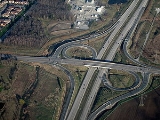
Parclo interchange
Encyclopedia

Cloverleaf interchange
A cloverleaf interchange is a two-level interchange in which left turns, reverse direction in left-driving regions, are handled by ramp roads...
. The parclo interchange was developed by the Ontario Ministry of Transportation
Ministry of Transportation (Ontario)
The Ministry of Transportation of Ontario is the provincial ministry of the government of Ontario which is responsible for transport infrastructure and related law in Ontario. The ministry traces its roots back over a century to the 1890s, when the province began training Provincial Road Building...
as a replacement for the cloverleaf on 400-Series Highways
400-series highways (Ontario)
The 400-series highways are a network of controlled-access highways throughout the southern portion of the Canadian province of Ontario, forming a special subset of the provincial highway system. They are analogous to the Interstate Highway System in the United States or the British Motorway...
, removing the dangerous weaving patterns and allowing for more acceleration and deceleration space on the freeway. The design has been well received, and has since become one of the most popular freeway-to-arterial
Arterial road
An arterial road, or arterial thoroughfare, is a high-capacity urban road. The primary function of an arterial road is to deliver traffic from collector roads to freeways, and between urban centres at the highest level of service possible. As such, many arteries are limited-access roads, or feature...
interchange
Interchange (road)
In the field of road transport, an interchange is a road junction that typically uses grade separation, and one or more ramps, to permit traffic on at least one highway to pass through the junction without directly crossing any other traffic stream. It differs from a standard intersection, at which...
designs in North America. It has also been used occasionally in some Europe
Europe
Europe is, by convention, one of the world's seven continents. Comprising the westernmost peninsula of Eurasia, Europe is generally 'divided' from Asia to its east by the watershed divides of the Ural and Caucasus Mountains, the Ural River, the Caspian and Black Seas, and the waterways connecting...
an countries, such as Germany
Germany
Germany , officially the Federal Republic of Germany , is a federal parliamentary republic in Europe. The country consists of 16 states while the capital and largest city is Berlin. Germany covers an area of 357,021 km2 and has a largely temperate seasonal climate...
and the Netherlands
Netherlands
The Netherlands is a constituent country of the Kingdom of the Netherlands, located mainly in North-West Europe and with several islands in the Caribbean. Mainland Netherlands borders the North Sea to the north and west, Belgium to the south, and Germany to the east, and shares maritime borders...
.
Relationship with other interchanges
A diamond interchangeDiamond interchange
A diamond interchange is a common type of road junction, used where a freeway crosses a minor road. The freeway itself is grade-separated from the minor road, one crossing the other over a bridge...
has four ramps.
A cloverleaf interchange
Cloverleaf interchange
A cloverleaf interchange is a two-level interchange in which left turns, reverse direction in left-driving regions, are handled by ramp roads...
has eight ramps, as does a stack interchange
Stack interchange
A stack interchange is a free-flowing grade separated junction between two roads.In countries where one drives on the right, left turns are handled by semi-directional flyover/under ramps...
.
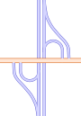
A parclo is then somewhere in between, although six is the most common.
Naming
In OntarioOntario
Ontario is a province of Canada, located in east-central Canada. It is Canada's most populous province and second largest in total area. It is home to the nation's most populous city, Toronto, and the nation's capital, Ottawa....
, the specific variation is identified by a letter/number suffix after the name. Other jurisdictions do not have naming conventions, so Ontario's naming conventions are used in this article. The letter A designates that two ramps meet the freeway before the driver crosses the arterial road, while B designates that two ramps meet the freeway past the crossing. The number designates how many quadrants of the interchange contain ramps. In left-hand drive countries, the ramps function the same as in right-hand drive countries, but ramps with the same designation appear visually reversed. Common parclo configurations include the Parclo A2, Parclo B2 and Parclo A4.
A2 and B2
A4

Traffic exiting the freeway to the arterial road is provided with a long, relatively straight exit ramp, preventing most speed-related rollovers. These exit ramps are also frequently multi-laned to accommodate traffic turning left, right, or going straight ahead in some cases. Traffic signals are commonly installed at the end of the exit ramp to regulate the freeway traffic flowing onto the arterial.
The Parclo A4 is particularly well-suited to suburban areas with high traffic levels; Ontario freeways built in the Greater Toronto Area
Greater Toronto Area
The Greater Toronto Area is the largest metropolitan area in Canada, with a 2006 census population of 5.5 million. The Greater Toronto Area is usually defined as the central city of Toronto, along with four regional municipalities surrounding it: Durham, Halton, Peel, and York...
since the 1970s such as Highway 403, Highway 404, and Highway 410 use this design at almost all individual junctions except where land conditions do not permit it. The first freeway constructed in the GTA thirty years later, Highway 407, still retains the Parclo A4 interchanges wherever possible.
Caltrans favors this form for some recent projects, for example the reconstruction of I-880. They often replaced previous full cloverleafs. All exiting traffic for both directions has a relatively straight ramp and is controlled by a traffic light. Running off the road on an entering ramp is much less likely than on an exiting ramp. Metering lights are a common feature on the entering ramps.
B4
The Parclo B4 interchange superficially appears to be a mirror image of the Parclo A4. However, the B4 design provides freeway-to-arterial ramps without traffic lights, while traffic turning left from the arterial must cross opposing traffic. Although this design has the potential to flood the arterial with more freeway traffic than the Parclo A4, one particular advantage is the ability to coordinate the traffic signals on the arterial in both directions independently. This is useful when there is more through-movement traffic on the arterial than turning traffic.The Parclo B4 is less common in Ontario
Ontario
Ontario is a province of Canada, located in east-central Canada. It is Canada's most populous province and second largest in total area. It is home to the nation's most populous city, Toronto, and the nation's capital, Ottawa....
than the Parclo A4, with the only examples being the following:
- Highway 402/Highway 40Highway 40 (Ontario)Highway 40 is the main North-South Provincial highway in Southwestern Ontario, linking Chatham, Ontario to Sarnia, Ontario.- Origins :The road originally connected Highway 2 in Chatham, Ontario to Highway 7/Highway 22 in Sarnia, Ontario. It was created in 1934...
interchange in SarniaSarnia, OntarioSarnia is a city in Southern Ontario, Canada . It is the largest city on Lake Huron and is located where the upper Great Lakes empty into the St. Clair River.... - the interchange at Lauzon Parkway and the E. C. Row ExpresswayE. C. Row ExpresswayThe E C Row Expressway is a municipal expressway in the Canadian city of Windsor, Ontario. It divides the city in half as it crosses it between the Ojibway Parkway in the west and Banwell Road in the east. The expressway is named after Ohio born Edgar Charles Row, the president of Chrysler Canada...
in WindsorWindsor, OntarioWindsor is the southernmost city in Canada and is located in Southwestern Ontario at the western end of the heavily populated Quebec City – Windsor Corridor. It is within Essex County, Ontario, although administratively separated from the county government. Separated by the Detroit River, Windsor... - Highway 17Highway 17 (Ontario)King's Highway 17, more commonly known as Highway 17, is a provincially maintained highway and the primary route of the Trans-Canada Highway through the Canadian province of Ontario. It begins at the Manitoba border west of Kenora and ends south of Arnprior at the western terminus of Highway 417, ...
/Municipal Road 55Greater Sudbury Road 55Sudbury Municipal Road 55 is a municipal road in the city of Greater Sudbury, Ontario, Canada. Extending from Whitefish to Coniston under a variety of street names, the road's entire length is a former alignment of Highway 17 and the Trans-Canada Highway....
interchange in Sudbury - Highway 406/St. David's Road interchange on the border of St. Catharines and ThoroldThorold, OntarioThorold is a city in Ontario, Canada, located on the Niagara Escarpment. It is also the seat of the Regional Municipality of Niagara....
- Highway 400 and Dunlop street in BarrieBarrieBarrie may refer to:* Barrie, city in Ontario, Canada* Barrie , Canadian federal electoral district* Barrie , provincial electoral district* Barrie—Simcoe—Bradford, former Canadian electoral district...
(but this interchange is mandatory due to the angle the 2 roads meet at)
Three exist in British Columbia
British Columbia
British Columbia is the westernmost of Canada's provinces and is known for its natural beauty, as reflected in its Latin motto, Splendor sine occasu . Its name was chosen by Queen Victoria in 1858...
. In addition, the Solomon Pond Road interchange on I-290
Interstate 290 (Massachusetts)
Interstate 290 runs for from Auburn, Massachusetts to Marlborough, Massachusetts. It is a continuation of I-395 north of I-90 and runs through downtown Worcester, Massachusetts, I-190 splits off, and I-290 runs across Lake Quinsigamond and east to I-495 in Marlborough...
in Northborough, Massachusetts
Northborough, Massachusetts
Northborough is a town in Worcester County, Massachusetts, United States. The official spelling of the town's name is "Northborough", but the shorter spelling "Northboro" is also used...
was converted from a B2 interchange to a B4 interchange in the mid-1990s with the construction of the Solomon Pond Mall
Solomon Pond Mall
The Solomon Pond Mall is operated and co-owned by Simon Property Group and is located off Interstate 290, near its terminus at Interstate 495, in Marlborough, Massachusetts....
. The US 83 interchange on I-80 in North Platte, Nebraska
North Platte, Nebraska
North Platte is a city in and the county seat of Lincoln County, Nebraska, United States. It is located in the southwestern part of the state, along Interstate 80, at the confluence of the North and South Platte Rivers forming the Platte River...
has also recently been upgraded to a B4 from a diamond
Diamond interchange
A diamond interchange is a common type of road junction, used where a freeway crosses a minor road. The freeway itself is grade-separated from the minor road, one crossing the other over a bridge...
.
At least three B4 designs are known to exist in Kentucky
Kentucky
The Commonwealth of Kentucky is a state located in the East Central United States of America. As classified by the United States Census Bureau, Kentucky is a Southern state, more specifically in the East South Central region. Kentucky is one of four U.S. states constituted as a commonwealth...
:
- The Taylorsville RoadKentucky Route 155Kentucky Route 155 is a 20.815 mile long state highway in the U.S. state of Kentucky. The route originates at a junction with U.S. Route 31E and US 150 in Louisville, Kentucky. On the other side of intersection, KY 155 becomes a local road called Trevilian Way...
interchange with the Watterson ExpresswayInterstate 264 (Kentucky)The Henry Watterson Expressway, also known as the Georgia Davis Powers/Shawnee Expressway west of US 31W, is one of two Interstate Highways in the United States designated as Interstate 264 . It is 22.93 miles in length, and runs an open circle around central Louisville, Kentucky...
in LouisvilleLouisville, KentuckyLouisville is the largest city in the U.S. state of Kentucky, and the county seat of Jefferson County. Since 2003, the city's borders have been coterminous with those of the county because of a city-county merger. The city's population at the 2010 census was 741,096...
. The B4 design was necessary in this case because of the angle at which Taylorsville Road crosses the Watterson. - The US 127U.S. Route 127U.S. Route 127 is a long north–south United States highway in the eastern half of the United States. The southern terminus of the route is at U.S. Route 27 in Chattanooga, Tennessee. The northern terminus is at Interstate 75 near Grayling, Michigan...
interchange with Interstate 64Interstate 64Interstate 64 is an Interstate Highway in the Midwestern and Southeastern United States. Its western terminus is at I-70, U.S. 40, and U.S. 61 in Wentzville, Missouri. Its eastern terminus is at an interchange with I-264 and I-664 at Bowers Hill in Chesapeake, Virginia. As I-64 is concurrent with...
in FrankfortFrankfort, KentuckyFrankfort is a city in Kentucky that serves as the state capital and the county seat of Franklin County. The population was 27,741 at the 2000 census; by population it is the 5th smallest state capital in the United States...
. - US 127 has a second B4 interchange at the Bluegrass ParkwayBluegrass ParkwayThe Martha Layne Collins Blue Grass Parkway is a controlled-access highway running from Elizabethtown, Kentucky to Woodford County, Kentucky, for a length of 71.134 miles . It intersects with Interstate 65 at its western terminus, and U.S. Route 60 at its eastern terminus. It is one of nine...
near LawrenceburgLawrenceburg, KentuckyLawrenceburg is a city in Anderson County, Kentucky, United States. The population was 10,505 at the 2010 census. It is the county seat of Anderson County...
, about 15 miles (24 km) south of the I-64 crossing. This particular interchange is a conversion from a four-loop design at the location of one of the toll booths on the Bluegrass Parkway before its conversion into a freeway. Toll booths were located directly below US 127; through traffic used the through lanes, while both entering and exiting traffic shared a lane directly to the right of the through lanes. The old design was standard for interchanges at toll booths in Kentucky's parkway system of controlled-access toll roads; even though tolls have been removed from all of the roads, many of the old designs still exist at former toll booth sites.
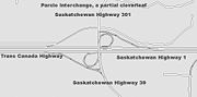
A Parclo B4 in south Calgary
Calgary
Calgary is a city in the Province of Alberta, Canada. It is located in the south of the province, in an area of foothills and prairie, approximately east of the front ranges of the Canadian Rockies...
is subject to the traffic flooding problem on a daily basis. Traffic coming off the Macleod Trail freeway overwhelms Anderson Road, resulting significant delays and frequent accidents. The style of intersection was made necessary due to the presence of a small private cemetery in one quadrant of the interchange: under the Cemetery Act of Alberta, cemeteries may not be moved or developed under any circumstance.
Some Parclo B4 interchanges such as the intersection of Interstate 40
Interstate 40
Interstate 40 is the third-longest major east–west Interstate Highway in the United States, after I-90 and I-80. Its western end is at Interstate 15 in Barstow, California; its eastern end is at a concurrency of U.S. Route 117 and North Carolina Highway 132 in Wilmington, North Carolina...
and U.S. Route 401
U.S. Route 401
U.S. Route 401 is an north–south United States highway, a spur of U.S. Route 1, that traverses along the fall line from Sumter, South Carolina to Interstate 85 near Wise, North Carolina.-Route description:...
in Raleigh have been fitted with signals at each ramp meeting the arterial in order to allow more lanes on the offramps. This technique along with the ability to provide two-way signal progression along the arterial allows the Parclo B4 to handle an extremely high flow of traffic along the arterial.
Other variations
Parclo designs with only two quadrants are commonly referred to as folded diamonds, due to their similarity with diamond interchangeDiamond interchange
A diamond interchange is a common type of road junction, used where a freeway crosses a minor road. The freeway itself is grade-separated from the minor road, one crossing the other over a bridge...
s. Sometimes the ramps in a folded diamond are actually local streets; surface roads upgraded to higher standards often do this to save money on land acquisition. This type of interchange long predates the Parclo; the Merritt Parkway
Merritt Parkway
The Merritt Parkway is a historic limited-access parkway in Fairfield County, Connecticut. The parkway is known for its scenic layout, its uniquely styled signage, and the architecturally elaborate overpasses along the route. It is designated as a National Scenic Byway and is also listed in the...
and Queen Elizabeth Way
Queen Elizabeth Way
The Queen Elizabeth Way, commonly abbreviated as the QEW, is a 400-Series highway in the Canadian province of Ontario. The freeway links Buffalo, New York and the Niagara Peninsula with Toronto. It begins at the Peace Bridge in Fort Erie and travels around the western shore of Lake Ontario, ending...
, both built in the 1930s, used mainly folded diamonds and cloverleaves
Cloverleaf interchange
A cloverleaf interchange is a two-level interchange in which left turns, reverse direction in left-driving regions, are handled by ramp roads...
. Another example of this is Highway 401's interchange with Highway 2
Highway 2 (Ontario)
King's Highway 2, usually referred to simply as Highway 2 is a provincially maintained highway in Ontario. Once the primary east–west route across the southern end of the province, Highway 2 became mostly redundant in the 1960s following the completion of Highway 401, which more or less...
east of Tilbury (Exit 63): the ramps also have intersections fairly close to the freeway to allow traffic to continue on a rural country road (Jeannette's Creak Road / McKinlay Road) which formerly met Highway 2. http://maps.google.ca/maps?f=q&hl=en&geocode=&q=Tilbury,+ontario&ie=UTF8&ll=42.278928,-82.374802&spn=0.016956,0.039911&z=15&om=1
Depending on traffic and land needs, hybrid designs, such as the Parclo AB and Parclo A3, can be created. Other variants, not describable using Ontario's system, eliminate one or more outside ramps, while leaving the loop ramps in those quadrants. In the United States, folded diamonds are frequently used in interchanges with roads that have a railroad line closely paralleling the surface street; entrance/exit ramps are not permitted to have level crossing
Level crossing
A level crossing occurs where a railway line is intersected by a road or path onone level, without recourse to a bridge or tunnel. It is a type of at-grade intersection. The term also applies when a light rail line with separate right-of-way or reserved track crosses a road in the same fashion...
s in modern American practice.
Freeway-to-freeway interchanges
In the late 1960s, there were parclo designs modified for freeway traffic. The ramps are longer to allow for higher speeds, particularly the loop ramp radii, which are enlarged to allow a recommended 40 km/h (24.9 mph) instead of 30 km/h (18.6 mph). In a right-hand traffic (RHT) system, the signalized left turn is eliminated by an underpass or overpass.Examples include the Highway 401-404 junction, and the former interchange
High Five Interchange
thumb|High Five interchange.The High Five Interchange is a five-level freeway interchange, designed by the HNTB Corporation, that connects Lyndon B. Johnson Freeway and Central Expressway in Dallas, Texas, United States...
between I-635
Interstate 635 (Texas)
Interstate 635 or the Lyndon B. Johnson Freeway is a partial loop around Dallas, Texas between Interstate 20 in Balch Springs, Texas and State Highway 121 at the north entrance of the Dallas-Fort Worth International Airport in Grapevine, Texas. The route is long...
and US 75
Central Expressway (Dallas)
Central Expressway is a north–south highway in Dallas, Texas and surrounding areas.- North Central Expressway :The best-known section is the North Central Expressway, a name for a freeway section of U.S. Highway 75 between downtown Dallas and McKinney, Texas...
, the latter which has since been replaced by a five-level stack.http://www.texasfreeway.com/Dallas/construction/high_five/high_five_main.shtmlhttp://tti.tamu.edu/publications/researcher/v40n2/images/high5before.jpg
Clover-stack
More recently, there has been the cloverleaf-stack or clover-stack (also known as a partial stack or hybrid parclo/stack) which is a three level freeway-to-freeway interchange which mostly resembles the Parclo A4, but adds third-level flyover ramps to eliminate the need for signalized left turns (in a right-hand traffic (RHT) system). Though having lower capacity than a four-level stack interchange, particularly due to the loop ramps, clover-stacks can be constructed significantly cheaper and also require less land. Alternatively, clover-stacks are formerly cloverleafCloverleaf
-Places:*Cloverleaf, Louisville, Kentucky, a neighborhood*Cloverleaf, Texas, a suburb of Houston*Cloverleaf Local School District in southern Medina County, Ohio-Science and technology:*A representation of the chemical structure of a transfer RNA molecule...
interchanges with two loop ramps (typically diagonal from each other) replaced with flyover ramps. Examples of clover-stacks include the Highway 407 interchanges with Highways 410 and Highway 404 in Toronto, and the Interstate 79
Interstate 79
Interstate 79 is an Interstate Highway in the eastern United States, designated from Interstate 77 in Charleston, West Virginia to Pennsylvania Route 5 and Pennsylvania Route 290 in Erie, Pennsylvania...
interchange with Interstate 376
Interstate 376
Interstate 376 is a major auxiliary route of the Interstate Highway System in the U.S. state of Pennsylvania, located entirely within the Allegheny Plateau. It runs from I-80 near Sharon south and east to a junction with the Pennsylvania Turnpike in Monroeville, after having crossed the Turnpike...
in Pittsburgh.
The Highway 401-Allen Road
Allen Road
William R. Allen Road, known more commonly as Allen Road, The Allen Expressway or simply The Allen and formerly as the Spadina Expressway, is a short expressway/freeway in Toronto, Ontario, which runs from Kennard Avenue in the north, to Eglinton Avenue West in the south...
interchange is a hybrid of the turbine and clover-stack, with some ramps dedicated to serving the adjacent Yorkdale Mall rather than freeway to freeway traffic. The turbine/whirlpool requires fewer levels while retaining semi-directional ramps throughout and has the left-turning ramps sweep around the center of the interchange in a spiral
Spiral
In mathematics, a spiral is a curve which emanates from a central point, getting progressively farther away as it revolves around the point.-Spiral or helix:...
pattern. This has slightly less capacity because the ramps turn and change height more quickly.
Implementation

California
California is a state located on the West Coast of the United States. It is by far the most populous U.S. state, and the third-largest by land area...
, Caltrans currently has a policy that whenever cloverleaf interchanges between freeways and surface streets are being rebuilt to handle higher traffic loads, they are turned into parclo interchanges by removing some of the loop ramps (or in rare cases bridges will be added between adjacent loop ramps — see cloverleaf interchange
Cloverleaf interchange
A cloverleaf interchange is a two-level interchange in which left turns, reverse direction in left-driving regions, are handled by ramp roads...
for details). However, as for cloverleaf interchanges between freeways, they are being unwound into partial stack interchange
Stack interchange
A stack interchange is a free-flowing grade separated junction between two roads.In countries where one drives on the right, left turns are handled by semi-directional flyover/under ramps...
s or made safer with slip ramps as funds permit. Ontario has a similar policy, having upgraded many full cloverleaf interchanges to six-ramp parclos in the 1990s.
Various forms of parclo interchanges are used on the North Luzon Expressway
North Luzon Expressway
The North Luzon Expressway , and which is formerly called the North Diversion Road, and officially known as Radial Road 8 is a 4 to 8-lane limited-access toll expressway that connects Metro Manila to the provinces of the Central Luzon region in the Philippines...
in the Philippines
Philippines
The Philippines , officially known as the Republic of the Philippines , is a country in Southeast Asia in the western Pacific Ocean. To its north across the Luzon Strait lies Taiwan. West across the South China Sea sits Vietnam...
. The configuration of parclo interchanges (particularly those of the "folded diamond" type) allows for the consolidation of toll barriers at points where onramps and offramps run alongside each other. A single large barrier can serve each onramp/offramp pair simultaneously, reducing construction and operation expenses.