
Indiana State Road 71
Encyclopedia
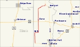
State Road 71 in west-central Indiana consists of two discontinuous north–south segments of two-lane rural roadway near the Illinois
border.
. The southern terminus is at State Road 163
in the town of Blanford
. The road passes north through the towns of West Clinton and St. Bernice. It crosses U.S. Route 36
just before passing through the town of Dana
. It passes just to the west of the Newport Chemical Depot
, then heads northeast to its northern terminus at State Road 63
northwest of Newport
.
.svg.png)
near Ambia
. It passes through the small towns of Dunnington
and Freeland Park
, then crosses State Road 18
. It passes through the town of Raub
where it crosses the Kankakee, Beaverville and Southern Railroad
on its way from Earl Park
northwest through Sheldon, Illinois
. The northern terminus at U.S. Route 24
/U.S. Route 52
about two miles (3 km) directly west of Kentland
. The highway is mostly within Benton County
, but the northernmost portion, about two miles (3 km) long, is in Newton County
.
.svg.png)
|colspan=5 align="center"| Gap in route
Illinois
Illinois is the fifth-most populous state of the United States of America, and is often noted for being a microcosm of the entire country. With Chicago in the northeast, small industrial cities and great agricultural productivity in central and northern Illinois, and natural resources like coal,...
border.
Southern section
This section is about 20 miles (32.2 km) long and is entirely within Vermillion CountyVermillion County, Indiana
Vermillion County lies in western Indiana between the Illinois border and the Wabash River. It was officially established in 1824 and was the 50th Indiana county to be formed. It is included in the Terre Haute, Indiana, Metropolitan Statistical Area. The county seat is Newport.According to the 2010...
. The southern terminus is at State Road 163
Indiana State Road 163
State Road 163 in the U.S. State of Indiana is a short route in Vermillion and Parke counties. Though it is an odd-numbered route, it is an east–west route.-Route description:...
in the town of Blanford
Blanford, Indiana
Blanford is a town in Clinton Township, Vermillion County, Indiana, United States....
. The road passes north through the towns of West Clinton and St. Bernice. It crosses U.S. Route 36
U.S. Route 36
U.S. Route 36 is an east–west United States highway that runs for from Rocky Mountain National Park, Colorado to Uhrichsville, Ohio. The highway's western terminus is at Deer Ridge Junction, an intersection in Rocky Mountain National Park, Colorado, where it meets U.S. Route 34. Its eastern...
just before passing through the town of Dana
Dana, Indiana
Dana is a town in Helt Township, Vermillion County, Indiana, United States. The population was 608 at the 2010 census. It is primarily a farming community.Famed World War II war correspondent Ernie Pyle was born on a tenant farm near Dana...
. It passes just to the west of the Newport Chemical Depot
Newport Chemical Depot
The Newport Chemical Depot, previously known as the Wabash River Ordinance Works and the Newport Army Ammunition Plant, was a bulk chemical storage and destruction facility in west central Indiana, thirty miles north of Terre Haute operated by the United States Army...
, then heads northeast to its northern terminus at State Road 63
Indiana State Road 63
State Road 63 in the U. S. state of Indiana is a north–south route in the western portion of the state. Until mid-2008, it covered a distance of just over , but now is a discontinuous route. For , from the city of Terre Haute until it rejoins U.S. Route 41 near Carbondale, it is a four-lane...
northwest of Newport
Newport, Indiana
Newport is a town in Vermillion Township, Vermillion County, Indiana, United States. The population was 515 at the 2010 census. The town is the county seat of Vermillion County.-Geography:Newport is located at ....
.
Northern section
This is a straight 17.5 miles (28.2 km) north–south road except for a small jog about halfway along its length. The southern terminus is at State Road 352Indiana State Road 352
State Road 352 in the U.S. state of Indiana is an east–west state highway in Benton County in the west-central part of the state.-Route description:...
near Ambia
Ambia, Indiana
Ambia is a town in Hickory Grove Township, Benton County, Indiana, United States. The population was 239 at the 2010 census. It is part of the Lafayette, Indiana Metropolitan Statistical Area.-History:...
. It passes through the small towns of Dunnington
Dunnington, Indiana
Dunnington is a small unincorporated town in Parish Grove Township, Benton County, Indiana, United States, now virtually extinct. Named for John Dunn, it stands about one and a half miles west of its smaller sister town, Dunn...
and Freeland Park
Freeland Park, Indiana
Freeland Park is an unincorporated town in Parish Grove Township, Benton County, Indiana. It is part of the Lafayette, Indiana Metropolitan Statistical Area.-History:...
, then crosses State Road 18
Indiana State Road 18
State Road 18 in the U.S. State of Indiana is an east–west route in North Central Indiana running from the Illinois border in Benton County almost to the Ohio border, terminating at U.S. Route 27 /State Road 67 in Jay County...
. It passes through the town of Raub
Raub, Indiana
Raub is an unincorporated town in York Township, Benton County, Indiana. It is part of the Lafayette, Indiana Metropolitan Statistical Area.-History:...
where it crosses the Kankakee, Beaverville and Southern Railroad
Kankakee, Beaverville and Southern Railroad
The Kankakee, Beaverville and Southern Railroad Company is a Class III railroad serving agricultural communities in east-central Illinois and west-central Indiana.-History:...
on its way from Earl Park
Earl Park, Indiana
Earl Park is a town in Richland Township, Benton County, Indiana, United States. The population was 348 at the 2010 census. It is part of the Lafayette, Indiana Metropolitan Statistical Area.-History:...
northwest through Sheldon, Illinois
Sheldon, Illinois
Sheldon is a village in Sheldon Township, Iroquois County, Illinois, United States. The population was 1,232 at the 2000 census, and 1,130 in 2009.-Geography:Sheldon is located at ....
. The northern terminus at U.S. Route 24
U.S. Route 24
U.S. Route 24 is one of the original United States highways of 1926. It originally ran from Pontiac, Michigan, in the east to Kansas City, Missouri, in the west. Today, the highway's eastern terminus is west of Clarkston, Michigan, at an intersection with I-75 and its western terminus is near...
/U.S. Route 52
U.S. Route 52
U.S. Route 52 is a United States highway that runs across the northern, eastern and southeastern regions of the United States. Contrary to most other even-numbered U.S...
about two miles (3 km) directly west of Kentland
Kentland, Indiana
Kentland is a town in Jefferson Township, Newton County, Indiana, United States. The population was 1,748 at the 2010 census. The town was founded in 1860 as "Kent", though this name was soon lengthened to Kentland. The name honors Alexander Kent, who acquired the then marshy plat and prepared it...
. The highway is mostly within Benton County
Benton County, Indiana
Benton County is located along in the northwest part of the U.S. state of Indiana, along the border with Illinois. As of 2010, the county's population was 8,854. It contains six incorporated towns as well as several small unincorporated settlements; it is also divided into 11 townships which...
, but the northernmost portion, about two miles (3 km) long, is in Newton County
Newton County, Indiana
Newton County is a county located in the U.S. state of Indiana. As of 2010, the population was 14,244. The county seat is Kentland.- History :...
.
Major intersections
|-|colspan=5 align="center"| Gap in route