
Troy, New Hampshire
Encyclopedia
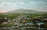
Troy is a town
in Cheshire County
, New Hampshire
, United States
. The population was 2,145 at the 2010 census. It is situated at the base of Mount Monadnock
.
The town center village, where 1,221 people resided at the 2010 census, is defined as the Troy census-designated place
(CDP), and is located along New Hampshire Route 12
. It is listed on the National Register of Historic Places
as Troy Village Historic District
.
that year, and included parts of Fitzwilliam
, Swanzey
and Richmond
. A prominent citizen and friend of Governor John Taylor Gilman
, Captain Benjamin Mann of Mason
, suggested the name Troy. His daughter, Betsy, was married to Samuel Wilson
, famous as "Uncle Sam
", and at that time a resident of Troy
, New York
. At least seven members of Wilson's family were living in the town at the time, thus securing the name. The town hall, built in 1813-1814 near the rail-fenced common
, was originally the village meetinghouse.
Troy Mills, which started making horse blankets in the mid-19th century, served as the backbone of the town's economy for nearly 100 years. In 1865, the company was sold by founder Thomas Goodall, who in 1867 would establish Goodall Mills in Sanford
, Maine
. Troy Mills declared bankruptcy
in late 2001, and ceased operations in 2002. The giant mill complex on Monadnock Street now houses two smaller spin-offs of Troy Mills—Knowlton Nonwovens and Cosmopolitan Textiles. The Troy trademark is now used for felt made by a company in West Virginia. Wooden-ware, pottery
and fine building stone were also once the products of Troy industries. As of 2008, Troy Mills was being renovated to become a retirement community.
, the town has a total area of 17.6 square miles (45.6 km²), of which 17.4 sq mi (45.1 km²) is land and 0.2 sq mi (0.517997622 km²) is water, comprising 0.91% of the town. Troy is drained by the South Branch of the Ashuelot River
. The highest point in town is the south summit of Gap Mountain
, at 1900 feet (579.1 m) above sea level
, near the eastern border.
Troy is crossed by New Hampshire Route 12
and New Hampshire Route 124
.
of 2000, there were 1,962 people, 733 households, and 527 families residing in the town. The population density
was 112.6 people per square mile (43.5/km²). There were 775 housing units at an average density of 44.5 per square mile (17.2/km²). The racial makeup of the town was 98.62% White, 0.05% African American, 0.25% Native American, 0.15% Asian, 0.25% from other races
, and 0.66% from two or more races. Hispanic or Latino of any race were 1.38% of the population. 18.7% were of American
, 13.4% French
, 11.8% English
, 10.6% Irish
, 8.4% French Canadian
, 8.2% Finnish and 7.0% Italian
ancestry according to Census 2000.
There were 733 households out of which 35.2% had children under the age of 18 living with them, 55.7% were married couples
living together, 11.2% had a female householder with no husband present, and 28.0% were non-families. 19.9% of all households were made up of individuals and 7.6% had someone living alone who was 65 years of age or older. The average household size was 2.68 and the average family size was 3.09.
In the town the population was spread out with 27.5% under the age of 18, 7.3% from 18 to 24, 31.0% from 25 to 44, 24.0% from 45 to 64, and 10.2% who were 65 years of age or older. The median age was 36 years. For every 100 females there were 93.1 males. For every 100 females age 18 and over, there were 92.6 males.
The median income for a household in the town was $41,875, and the median income for a family was $47,500. Males had a median income of $28,816 versus $23,980 for females. The per capita income
for the town was $17,323. About 3.8% of families and 7.9% of the population were below the poverty line, including 8.1% of those under age 18 and 7.4% of those age 65 or over.
.
New England town
The New England town is the basic unit of local government in each of the six New England states. Without a direct counterpart in most other U.S. states, New England towns are conceptually similar to civil townships in other states, but are incorporated, possessing powers like cities in other...
in Cheshire County
Cheshire County, New Hampshire
-Demographics:As of the census of 2000, there were 73,825 people, 28,299 households, and 18,790 families residing in the county. The population density was 104 people per square mile . There were 31,876 housing units at an average density of 45 per square mile...
, New Hampshire
New Hampshire
New Hampshire is a state in the New England region of the northeastern United States of America. The state was named after the southern English county of Hampshire. It is bordered by Massachusetts to the south, Vermont to the west, Maine and the Atlantic Ocean to the east, and the Canadian...
, United States
United States
The United States of America is a federal constitutional republic comprising fifty states and a federal district...
. The population was 2,145 at the 2010 census. It is situated at the base of Mount Monadnock
Mount Monadnock
Mount Monadnock, or Grand Monadnock, is the most prominent New England mountain peak south of the White Mountains and east of the Massachusetts Berkshires, and is the highest point in Cheshire County, New Hampshire...
.
The town center village, where 1,221 people resided at the 2010 census, is defined as the Troy census-designated place
Census-designated place
A census-designated place is a concentration of population identified by the United States Census Bureau for statistical purposes. CDPs are delineated for each decennial census as the statistical counterparts of incorporated places such as cities, towns and villages...
(CDP), and is located along New Hampshire Route 12
New Hampshire Route 12
New Hampshire Route 12 is a north-south state highway running across the western portion of New Hampshire from the Massachusetts state line to the Vermont state line at the Connecticut River.-Route description:...
. It is listed on the National Register of Historic Places
National Register of Historic Places
The National Register of Historic Places is the United States government's official list of districts, sites, buildings, structures, and objects deemed worthy of preservation...
as Troy Village Historic District
Troy Village Historic District
Troy Village Historic District is a historic district encompassing the village center, mostly along NH 12 in Troy, New Hampshire.It was added to the National Register of Historic Places in 2002....
.
History
Settled in 1762, by 1815 the community had grown so much that it sought its own incorporation. It was set off from MarlboroughMarlborough, New Hampshire
Marlborough is a town in Cheshire County, New Hampshire, United States. The population was 2,063 at the 2010 census. The town is home to the Kensan-Devan Wildlife Sanctuary at Meetinghouse Pond....
that year, and included parts of Fitzwilliam
Fitzwilliam, New Hampshire
Fitzwilliam is a town in Cheshire County, New Hampshire, United States. The population was 2,396 at the 2010 census. Fitzwilliam is home to Rhododendron State Park, a grove of native rhododendrons that bloom in mid-July.-History:...
, Swanzey
Swanzey, New Hampshire
Swanzey is a town in Cheshire County, New Hampshire, United States. The population was 7,230 at the 2010 census. In addition to the town center, Swanzey includes the villages of East Swanzey, West Swanzey, North Swanzey, and Westport.-History:...
and Richmond
Richmond, New Hampshire
Richmond is a town in Cheshire County, New Hampshire, United States. The population was 1,155 at the 2010 census.-History:The town was first chartered in 1735 by Governor Jonathan Belcher of Massachusetts...
. A prominent citizen and friend of Governor John Taylor Gilman
John Taylor Gilman
John Taylor Gilman was a farmer, shipbuilder, and statesman from Exeter, New Hampshire. He represented New Hampshire in the Continental Congress in 1782-1783 and was Governor of New Hampshire for 14 years, from 1794 to 1805, and from 1813 to 1816.Gilman was born in Exeter, New Hampshire, to a...
, Captain Benjamin Mann of Mason
Mason, New Hampshire
Mason is a town in Hillsborough County, New Hampshire, United States. The population was 1,382 at the 2010 census. Mason, together with Wilton, is home to Russell-Abbott State Forest.-History:...
, suggested the name Troy. His daughter, Betsy, was married to Samuel Wilson
Samuel Wilson
Samuel Wilson was a meat-packer from Troy, New York whose name is purportedly the source of the personification of the United States known as "Uncle Sam"....
, famous as "Uncle Sam
Uncle Sam
Uncle Sam is a common national personification of the American government originally used during the War of 1812. He is depicted as a stern elderly man with white hair and a goatee beard...
", and at that time a resident of Troy
Troy, New York
Troy is a city in the US State of New York and the seat of Rensselaer County. Troy is located on the western edge of Rensselaer County and on the eastern bank of the Hudson River. Troy has close ties to the nearby cities of Albany and Schenectady, forming a region popularly called the Capital...
, New York
New York
New York is a state in the Northeastern region of the United States. It is the nation's third most populous state. New York is bordered by New Jersey and Pennsylvania to the south, and by Connecticut, Massachusetts and Vermont to the east...
. At least seven members of Wilson's family were living in the town at the time, thus securing the name. The town hall, built in 1813-1814 near the rail-fenced common
Common land
Common land is land owned collectively or by one person, but over which other people have certain traditional rights, such as to allow their livestock to graze upon it, to collect firewood, or to cut turf for fuel...
, was originally the village meetinghouse.
Troy Mills, which started making horse blankets in the mid-19th century, served as the backbone of the town's economy for nearly 100 years. In 1865, the company was sold by founder Thomas Goodall, who in 1867 would establish Goodall Mills in Sanford
Sanford, Maine
Sanford is a town in York County, Maine, United States. The population was 20,798 in the 2010 census, the highest of the York County towns, and the 8th largest in the state. Situated on the Mousam River, Sanford includes the village of Springvale...
, Maine
Maine
Maine is a state in the New England region of the northeastern United States, bordered by the Atlantic Ocean to the east and south, New Hampshire to the west, and the Canadian provinces of Quebec to the northwest and New Brunswick to the northeast. Maine is both the northernmost and easternmost...
. Troy Mills declared bankruptcy
Bankruptcy
Bankruptcy is a legal status of an insolvent person or an organisation, that is, one that cannot repay the debts owed to creditors. In most jurisdictions bankruptcy is imposed by a court order, often initiated by the debtor....
in late 2001, and ceased operations in 2002. The giant mill complex on Monadnock Street now houses two smaller spin-offs of Troy Mills—Knowlton Nonwovens and Cosmopolitan Textiles. The Troy trademark is now used for felt made by a company in West Virginia. Wooden-ware, pottery
Pottery
Pottery is the material from which the potteryware is made, of which major types include earthenware, stoneware and porcelain. The place where such wares are made is also called a pottery . Pottery also refers to the art or craft of the potter or the manufacture of pottery...
and fine building stone were also once the products of Troy industries. As of 2008, Troy Mills was being renovated to become a retirement community.
Geography
According to the United States Census BureauUnited States Census Bureau
The United States Census Bureau is the government agency that is responsible for the United States Census. It also gathers other national demographic and economic data...
, the town has a total area of 17.6 square miles (45.6 km²), of which 17.4 sq mi (45.1 km²) is land and 0.2 sq mi (0.517997622 km²) is water, comprising 0.91% of the town. Troy is drained by the South Branch of the Ashuelot River
South Branch Ashuelot River
The South Branch of the Ashuelot River is a 17.4 mile long river located in southwestern New Hampshire in the United States. It is a tributary of the Ashuelot River, itself a tributary of the Connecticut River, which flows to Long Island Sound....
. The highest point in town is the south summit of Gap Mountain
Gap Mountain
Gap Mountain, located in Troy, New Hampshire, is a small monadnock with three summits ranging between and . The lower north and middle summits are mostly bald and offer panoramic views of the surrounding rural landscape and of the higher and more popular Mount Monadnock. The Metacomet-Monadnock...
, at 1900 feet (579.1 m) above sea level
Sea level
Mean sea level is a measure of the average height of the ocean's surface ; used as a standard in reckoning land elevation...
, near the eastern border.
Troy is crossed by New Hampshire Route 12
New Hampshire Route 12
New Hampshire Route 12 is a north-south state highway running across the western portion of New Hampshire from the Massachusetts state line to the Vermont state line at the Connecticut River.-Route description:...
and New Hampshire Route 124
New Hampshire Route 124
New Hampshire Route 124 is a long east–west highway in southern New Hampshire. It runs from Marlborough to the Massachusetts border....
.
Demographics
As of the censusCensus
A census is the procedure of systematically acquiring and recording information about the members of a given population. It is a regularly occurring and official count of a particular population. The term is used mostly in connection with national population and housing censuses; other common...
of 2000, there were 1,962 people, 733 households, and 527 families residing in the town. The population density
Population density
Population density is a measurement of population per unit area or unit volume. It is frequently applied to living organisms, and particularly to humans...
was 112.6 people per square mile (43.5/km²). There were 775 housing units at an average density of 44.5 per square mile (17.2/km²). The racial makeup of the town was 98.62% White, 0.05% African American, 0.25% Native American, 0.15% Asian, 0.25% from other races
Race (United States Census)
Race and ethnicity in the United States Census, as defined by the Federal Office of Management and Budget and the United States Census Bureau, are self-identification data items in which residents choose the race or races with which they most closely identify, and indicate whether or not they are...
, and 0.66% from two or more races. Hispanic or Latino of any race were 1.38% of the population. 18.7% were of American
United States
The United States of America is a federal constitutional republic comprising fifty states and a federal district...
, 13.4% French
French people
The French are a nation that share a common French culture and speak the French language as a mother tongue. Historically, the French population are descended from peoples of Celtic, Latin and Germanic origin, and are today a mixture of several ethnic groups...
, 11.8% English
English people
The English are a nation and ethnic group native to England, who speak English. The English identity is of early mediaeval origin, when they were known in Old English as the Anglecynn. England is now a country of the United Kingdom, and the majority of English people in England are British Citizens...
, 10.6% Irish
Irish people
The Irish people are an ethnic group who originate in Ireland, an island in northwestern Europe. Ireland has been populated for around 9,000 years , with the Irish people's earliest ancestors recorded having legends of being descended from groups such as the Nemedians, Fomorians, Fir Bolg, Tuatha...
, 8.4% French Canadian
French Canadian
French Canadian or Francophone Canadian, , generally refers to the descendents of French colonists who arrived in New France in the 17th and 18th centuries...
, 8.2% Finnish and 7.0% Italian
Italian people
The Italian people are an ethnic group that share a common Italian culture, ancestry and speak the Italian language as a mother tongue. Within Italy, Italians are defined by citizenship, regardless of ancestry or country of residence , and are distinguished from people...
ancestry according to Census 2000.
There were 733 households out of which 35.2% had children under the age of 18 living with them, 55.7% were married couples
Marriage
Marriage is a social union or legal contract between people that creates kinship. It is an institution in which interpersonal relationships, usually intimate and sexual, are acknowledged in a variety of ways, depending on the culture or subculture in which it is found...
living together, 11.2% had a female householder with no husband present, and 28.0% were non-families. 19.9% of all households were made up of individuals and 7.6% had someone living alone who was 65 years of age or older. The average household size was 2.68 and the average family size was 3.09.
In the town the population was spread out with 27.5% under the age of 18, 7.3% from 18 to 24, 31.0% from 25 to 44, 24.0% from 45 to 64, and 10.2% who were 65 years of age or older. The median age was 36 years. For every 100 females there were 93.1 males. For every 100 females age 18 and over, there were 92.6 males.
The median income for a household in the town was $41,875, and the median income for a family was $47,500. Males had a median income of $28,816 versus $23,980 for females. The per capita income
Per capita income
Per capita income or income per person is a measure of mean income within an economic aggregate, such as a country or city. It is calculated by taking a measure of all sources of income in the aggregate and dividing it by the total population...
for the town was $17,323. About 3.8% of families and 7.9% of the population were below the poverty line, including 8.1% of those under age 18 and 7.4% of those age 65 or over.
Education
Residents of Troy attending public high school go to Monadnock Regional High SchoolMonadnock Regional High School
Monadnock Regional High School is a public school in Swanzey, New Hampshire. The school serves seven towns in the Monadnock region, including Fitzwilliam, Gilsum, Richmond, Roxbury, Sullivan, Swanzey, and Troy.- Scheduling :...
.