
Trout Creek Mountains
Encyclopedia
The Trout Creek Mountains are a remote mountain range
in southeastern Oregon
and northern Nevada
, United States. The highest point in the range is Orevada View Benchmark. Most of the Trout Creek Mountains are public lands, administered by the Bureau of Land Management
. There is very little human development in the Trout Creek Mountains. However, there are grazing
allotments that created environmental concerns in the 1980s. The Trout Creek Mountain Working Group was formed in 1988 to help resolve the conflict between livestock owners and environmentalists.
are part of the Basin and Range Province of the Western United States
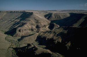
which is characterized by a series of parallel fault blocks forming long north-south oriented mountain ranges separated by wide high desert valleys. The Trout Creek Mountains are uplifted and tilted blocks, with steep escarpments along the southern and eastern sides of the range. The southern area of the range has numerous granitic outcroppings formed during the Cretaceous Period. These outcroppings are commonly found at the base of volcanic ridgelines.
The Trout Creek Mountains range is composed of basalt
from a series of shield volcanoes that once stood where the Steens Mountains are today. These volcanoes began erupting about 17 million years ago, producing a series of lava flows that spread across the land where the Trout Creek Mountains stand today. The eruptions lasted for about one million years. At least seventy separate lava flows occurred. Ultimately, the basalt layers in the Trout Creek area reached a thickness of about 4500 feet (1,371.6 m). However, the Trout Creek Mountains also have much older metamorphic rock
underlying the more recent basalt flows. These rocks may be related to some of the Triassic
formations of the Blue Mountains Province
to the north. These strata have diorite
and granodiorite
intrusions, probably formed in the Cretaceous Period.
One of the unique geologic features in the Trout Creek Mountains is McDermitt Caldera. The caldera
is a collapsed volcanic dome located in the southern part of the range. It was created by volcanic eruptions in the early Miocene
, about 19 million years ago. A total of five large ash-flows were produced along with a large rhyolite
dome structure. The caldera was formed when the dome collapsed about 16 million years ago.
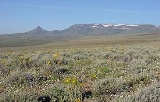
 The Trout Creek Mountains cover an area of 511 square miles (1,323.5 km²) (811 sq mi (2,100.5 km²) including surrounding lowland areas). The range runs 51 miles north to south and 36 miles east to west. Most of the Trout Creek range is in Oregon (78%); however, a portion of it extends into northern Nevada. The highest peak in the range is Orevada View Benchmark, which is 8506 feet (2,592.6 m) above sea level at its summit. It is located in Nevada, approximately one mile south of the Oregon border. The high point in Oregon is an unnamed ridge summit approximately two miles north of Orevada View. Just two miles south of Orevada View is Disaster Peak, an impressive, symmetrical butte that is visible throughout the region. At 7781 feet (2,371.6 m), Disaster Peak anchors the southern end of the range.
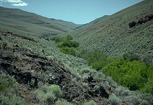
The terrain in the Trout Creek Mountains ranges from broad, flat basins and rolling ridges to high rock escarpments cut by deep canyons. The canyons have steep walls with loose talus slopes below. The rugged ridges are separated by high-desert basins
. There are meadows around spring
areas. The Trout Creek range has only a few streams
that flow year around. The two largest streams are Trout Creek and Whitehorse Creek, both drain into dry desert basins.
over the Oregon and California
coastal ranges and the Cascade Mountains before passing over the Trout Creek Mountains. This creates a rain shadow
effect that condenses most of the moisture in the Pacific air masses before reaching the Trout Creek Mountains. As a result, the average annual precipitation in the Trout Creek area ranges from 8 and 26 in (203.2 and 660.4 mm) per year. Over half of the annual precipitation occurs between the beginning of March and the end of June. Most of the rest falls as snow during the fall and winter months. Snowpack at elevations below 6000 feet (1,828.8 m) usually melts by April; however, at the higher elevations, snow often remains until mid-June. Local flooding often occurs in the spring as the snowpack melts.
The prevailing winds are west-southwest, with the highest winds normally in March and April. Short-duration, high-intensity thunderstorms are common between April and October. Those that occur during the summer months tend to be more isolated and often produce dry-lightning strikes.
and desert grasses. Other common shrubs include bitterbrush, snowberry, and ceanothus
. There are also patches of Mountain mahogany in some areas. Common grass species include Idaho fescue, bluebunch wheatgrass
, cheatgrass, western needlegrass
, Sandberg's bluegrass, Thurber's needlegrass, and bottlebrush squirreltail plus basin wildrye in some well drained areas.
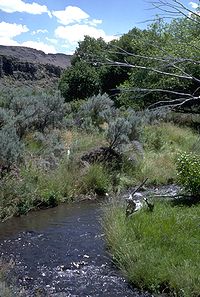
 Less than one percent of the land is meadow wetlands and riparian greenways. However, these areas are extremely important to the local ecosystem. There are high mountain meadows around springs. Most of the springs occur on gently sloping uplands or in stream bottoms. The meadows range in size from less than an acre (0.4 ha) to more than five acres (2 ha). Narrow riparian greenways follow the year-around streams. Many greenway areas have quaking aspens and willow
groves. Cottonwood and alder
groves can be found at lower elevations where slopes become flatter and the stream channels are wider. Sedges and rushes
are also native to these stream bottoms. Years of heavy livestock grazing in parts of the range resulted in the loss of some grass species and riparian zone plants as well as young aspen and willow trees.
The wildlife in the Trout Creek Mountains is adapted to the high desert environment. Pronghorn antelope are common in the open, sagebrush covered basins while Mule deer
like the cottonwood and willow groves. There are also Bighorn Sheep
and cougar in the high country. Jackrabbits and coyotes are common throughout the range. Bird species native to the Trout Creek Mountains include sage grouse
, Mountain Chickadee
s, Gray-headed Juncos, Black-throated Gray Warbler
, Virginia's Warbler
, MacGillivray's Warbler
, Pine Siskin
, Red Crossbill, Bushtit
, Hermit Thrush
, and Northern Goshawks, raven
s, and eagle
s.
Several streams in the Trout Creek Mountains have rare Lahontan cutthroat trout
. They include Willow Creek, Whitehorse Creek, Little Whitehorse Creek, Doolitle Creek, Fifteen Mile Creek, Indian Creek, Sage Canyon Creek, Line Canyon Creeks, and some tributaries of McDermitt Creek. Lahontan cutthroat trout were listed as an endangered species
in 1970; however, they were reclassified as threatened
in 1975.
 Most of the Trout Creek Mountains are public lands, administered by the Bureau of Land Management. The entire mountain range is very remote. As a result, there are few visitors. Camping
, hunting
, fishing
, hiking
, sightseeing and photography
are the most popular activities. There are also mining claims
and grazing
allotments in the mountains.
The Trout Creek Mountains offer a wilderness like experience. Since there are no campgrounds in the area, overnight visitors must be prepared for wilderness conditions. Hunters come to the area seeking trophy mule deer, antelope, chukar
s, and rabbits. Trout fishing is permitted on a catch and release
basis. The mountains also offer visitors the opportunity to hike on game trial in natural corridors that follow the secluded canyons and creek bottoms or cross-country along the open ridges and rim rocks. There are also Native American
Petroglyph
sites that can be explored; however, these sites are often difficult to find without a guide. Near the Whitehorse Ranch there are miles of trail designated for 4-wheel off-road vehicles
.
There are a large number of mining claims in the Trout Creek Mountains. However, mining has been very limited because the mineral depots found in the area have never been economical to extract.
Cattle
grazing in the Trout Creek Mountains began in the late 19th century. Today, the Bureau of Land Management oversees grazing allotments in the area. As a result of these allotments, cattle can be found grazing in some areas during the spring and summer. Their impact on the local environment was the subject of controversy in the 1980s.
As environmentalists pressed the Bureau of Land Management to close much of the Trout Creek range to grazing, frustrated ranchers joined the “sage brush rebellion” seeking to protect their grazing allotments. Initially, it appeared that the issue of grazing in the Trout Creek range would produce prolonged litigation with appeals potentially lasting decades. However, in 1988, a number of interest groups representing all side of the issue joined together to form the Trout Creek Mountain Working Group. The goal of the group was to find a solution acceptable to everyone, a plan that would protect both the ecological health of the land and the economic well-being of ranchers.
Initial members of the Trout Creek Mountain Working Group included:
Over the next several years the group continued to meet and discuss options for restoring the land without driving local ranchers out of business. All meetings were open to the public.
The group eventually endorsed a grazing management plan that provided for both the ecological health of sensitive riparian areas and the economic well-being of ranchers. In 1989, the Whitehorse Ranch agreed to rest two grazing allotments totaling 50000 acres (20,234.3 ha) to restore critical stream greenways and mountain pastures. The ranch’s allotment on Fifteen Mile Creek was rested for three years and its Willow Creek pasture received a five years rest before grazing was resumed. In addition, the grazing season in mountain pastures was reduced from four months to two, and the total number of cattle released in the allotment areas was reduced from 3,800 to 2,200. Finally, sensitive areas were fenced to protect them from cattle and additional water sources were constructed away from streams. Other ranches also agreed to rest specific pastures including Trout Creek, Cottonwood Creek, and the Whitehorse Butte allotments.
In 1991, the Bureau of Land Management approved a new grazing allotment management plan. It was based on the agreements made by the Trout Creek Mountain Working Group. The new plan took effect in 1992. Since then, vegetation in riparian areas of the Trout Creek Mountains have recovered, and studies by the United States Fish and Wildlife Service have verified the Lahontan cutthroat trout population is also recovering.
|-
|
|
|- align=center
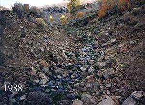
| Cottonwood Creek riparian area before restoration, 1988.
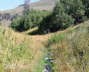
| Cottonwood Creek riparian area after restoration, 2002.
|}>
Mountain range
A mountain range is a single, large mass consisting of a succession of mountains or narrowly spaced mountain ridges, with or without peaks, closely related in position, direction, formation, and age; a component part of a mountain system or of a mountain chain...
in southeastern Oregon
Oregon
Oregon is a state in the Pacific Northwest region of the United States. It is located on the Pacific coast, with Washington to the north, California to the south, Nevada on the southeast and Idaho to the east. The Columbia and Snake rivers delineate much of Oregon's northern and eastern...
and northern Nevada
Nevada
Nevada is a state in the western, mountain west, and southwestern regions of the United States. With an area of and a population of about 2.7 million, it is the 7th-largest and 35th-most populous state. Over two-thirds of Nevada's people live in the Las Vegas metropolitan area, which contains its...
, United States. The highest point in the range is Orevada View Benchmark. Most of the Trout Creek Mountains are public lands, administered by the Bureau of Land Management
Bureau of Land Management
The Bureau of Land Management is an agency within the United States Department of the Interior which administers America's public lands, totaling approximately , or one-eighth of the landmass of the country. The BLM also manages of subsurface mineral estate underlying federal, state and private...
. There is very little human development in the Trout Creek Mountains. However, there are grazing
Grazing
Grazing generally describes a type of feeding, in which a herbivore feeds on plants , and also on other multicellular autotrophs...
allotments that created environmental concerns in the 1980s. The Trout Creek Mountain Working Group was formed in 1988 to help resolve the conflict between livestock owners and environmentalists.
Geology
The Trout Creek Mountains in southeastern OregonSoutheastern Oregon
Southeastern Oregon is a geographical term for the area along the state of Oregon's borders with Idaho, California, and Nevada. It includes the populous areas of Burns, Klamath Falls and Lakeview.-Counties:-Cities and towns:Burns |Chemult |Chiloquin |...
are part of the Basin and Range Province of the Western United States
Western United States
.The Western United States, commonly referred to as the American West or simply "the West," traditionally refers to the region comprising the westernmost states of the United States. Because the U.S. expanded westward after its founding, the meaning of the West has evolved over time...
which is characterized by a series of parallel fault blocks forming long north-south oriented mountain ranges separated by wide high desert valleys. The Trout Creek Mountains are uplifted and tilted blocks, with steep escarpments along the southern and eastern sides of the range. The southern area of the range has numerous granitic outcroppings formed during the Cretaceous Period. These outcroppings are commonly found at the base of volcanic ridgelines.
The Trout Creek Mountains range is composed of basalt
Basalt
Basalt is a common extrusive volcanic rock. It is usually grey to black and fine-grained due to rapid cooling of lava at the surface of a planet. It may be porphyritic containing larger crystals in a fine matrix, or vesicular, or frothy scoria. Unweathered basalt is black or grey...
from a series of shield volcanoes that once stood where the Steens Mountains are today. These volcanoes began erupting about 17 million years ago, producing a series of lava flows that spread across the land where the Trout Creek Mountains stand today. The eruptions lasted for about one million years. At least seventy separate lava flows occurred. Ultimately, the basalt layers in the Trout Creek area reached a thickness of about 4500 feet (1,371.6 m). However, the Trout Creek Mountains also have much older metamorphic rock
Metamorphic rock
Metamorphic rock is the transformation of an existing rock type, the protolith, in a process called metamorphism, which means "change in form". The protolith is subjected to heat and pressure causing profound physical and/or chemical change...
underlying the more recent basalt flows. These rocks may be related to some of the Triassic
Triassic
The Triassic is a geologic period and system that extends from about 250 to 200 Mya . As the first period of the Mesozoic Era, the Triassic follows the Permian and is followed by the Jurassic. Both the start and end of the Triassic are marked by major extinction events...
formations of the Blue Mountains Province
Blue Mountains (Oregon)
The Blue Mountains are a mountain range in the western United States, located largely in northeastern Oregon and stretching into southeastern Washington...
to the north. These strata have diorite
Diorite
Diorite is a grey to dark grey intermediate intrusive igneous rock composed principally of plagioclase feldspar , biotite, hornblende, and/or pyroxene. It may contain small amounts of quartz, microcline and olivine. Zircon, apatite, sphene, magnetite, ilmenite and sulfides occur as accessory...
and granodiorite
Granodiorite
Granodiorite is an intrusive igneous rock similar to granite, but containing more plagioclase than orthoclase-type feldspar. Officially, it is defined as a phaneritic igneous rock with greater than 20% quartz by volume where at least 65% of the feldspar is plagioclase. It usually contains abundant...
intrusions, probably formed in the Cretaceous Period.
One of the unique geologic features in the Trout Creek Mountains is McDermitt Caldera. The caldera
Caldera
A caldera is a cauldron-like volcanic feature usually formed by the collapse of land following a volcanic eruption, such as the one at Yellowstone National Park in the US. They are sometimes confused with volcanic craters...
is a collapsed volcanic dome located in the southern part of the range. It was created by volcanic eruptions in the early Miocene
Miocene
The Miocene is a geological epoch of the Neogene Period and extends from about . The Miocene was named by Sir Charles Lyell. Its name comes from the Greek words and and means "less recent" because it has 18% fewer modern sea invertebrates than the Pliocene. The Miocene follows the Oligocene...
, about 19 million years ago. A total of five large ash-flows were produced along with a large rhyolite
Rhyolite
This page is about a volcanic rock. For the ghost town see Rhyolite, Nevada, and for the satellite system, see Rhyolite/Aquacade.Rhyolite is an igneous, volcanic rock, of felsic composition . It may have any texture from glassy to aphanitic to porphyritic...
dome structure. The caldera was formed when the dome collapsed about 16 million years ago.
Topography
The terrain in the Trout Creek Mountains ranges from broad, flat basins and rolling ridges to high rock escarpments cut by deep canyons. The canyons have steep walls with loose talus slopes below. The rugged ridges are separated by high-desert basins
Basin and Range
The Basin and Range Province is a vast physiographic region defined by a unique topographic expression. Basin and Range topography is characterized by abrupt changes in elevation, alternating between narrow faulted mountain chains and flat arid valleys or basins...
. There are meadows around spring
Spring (hydrosphere)
A spring—also known as a rising or resurgence—is a component of the hydrosphere. Specifically, it is any natural situation where water flows to the surface of the earth from underground...
areas. The Trout Creek range has only a few streams
STREAMS
In computer networking, STREAMS is the native framework in Unix System V for implementing character devices.STREAMS was designed as a modular architecture for implementing full-duplex I/O between kernel or user space processes and device drivers. Its most frequent uses have been in developing...
that flow year around. The two largest streams are Trout Creek and Whitehorse Creek, both drain into dry desert basins.
Climate
The Trout Creek Mountains are semiarid due to the dominant weather pattern that moves air east from the Pacific OceanPacific Ocean
The Pacific Ocean is the largest of the Earth's oceanic divisions. It extends from the Arctic in the north to the Southern Ocean in the south, bounded by Asia and Australia in the west, and the Americas in the east.At 165.2 million square kilometres in area, this largest division of the World...
over the Oregon and California
California
California is a state located on the West Coast of the United States. It is by far the most populous U.S. state, and the third-largest by land area...
coastal ranges and the Cascade Mountains before passing over the Trout Creek Mountains. This creates a rain shadow
Rain shadow
A rain shadow is a dry area on the lee side of a mountainous area. The mountains block the passage of rain-producing weather systems, casting a "shadow" of dryness behind them. As shown by the diagram to the right, the warm moist air is "pulled" by the prevailing winds over a mountain...
effect that condenses most of the moisture in the Pacific air masses before reaching the Trout Creek Mountains. As a result, the average annual precipitation in the Trout Creek area ranges from 8 and 26 in (203.2 and 660.4 mm) per year. Over half of the annual precipitation occurs between the beginning of March and the end of June. Most of the rest falls as snow during the fall and winter months. Snowpack at elevations below 6000 feet (1,828.8 m) usually melts by April; however, at the higher elevations, snow often remains until mid-June. Local flooding often occurs in the spring as the snowpack melts.
The prevailing winds are west-southwest, with the highest winds normally in March and April. Short-duration, high-intensity thunderstorms are common between April and October. Those that occur during the summer months tend to be more isolated and often produce dry-lightning strikes.
Ecology
Vegetation in the Trout Creek Mountains is dominated by large sagebrushSagebrush
Sagebrush is a common name of a number of shrubby plant species in the genus Artemisia native to western North America;Or, the sagebrush steppe ecoregion, having one or more kinds of sagebrush, bunchgrasses and others;...
and desert grasses. Other common shrubs include bitterbrush, snowberry, and ceanothus
Ceanothus
Ceanothus L. is a genus of about 50–60 species of shrubs or small trees in the buckthorn family Rhamnaceae. The genus is confined to North America, the center of its distribution in California, with some species in the eastern United States and southeast Canada, and others extending as far south...
. There are also patches of Mountain mahogany in some areas. Common grass species include Idaho fescue, bluebunch wheatgrass
Bluebunch wheatgrass
Pseudoroegneria spicata is a species of grass known by the common name Bluebunch Wheatgrass. This native western North American perennial bunchgrass is known by the scientific synonyms Elymus spicatus and Agropyron spicatum. The grass can be found from Alaska to Texas. It occurs in many types of...
, cheatgrass, western needlegrass
Achnatherum occidentale
Achnatherum occidentale is a species of grass known by the common name western needlegrass. It is native to western North America from British Columbia to California to Colorado, where it grows in many types of habitat. This is a tufting perennial bunchgrass forming tight clumps of erect stems up...
, Sandberg's bluegrass, Thurber's needlegrass, and bottlebrush squirreltail plus basin wildrye in some well drained areas.
Willow
Willows, sallows, and osiers form the genus Salix, around 400 species of deciduous trees and shrubs, found primarily on moist soils in cold and temperate regions of the Northern Hemisphere...
groves. Cottonwood and alder
Alder
Alder is the common name of a genus of flowering plants belonging to the birch family . The genus comprises about 30 species of monoecious trees and shrubs, few reaching large size, distributed throughout the North Temperate Zone and in the Americas along the Andes southwards to...
groves can be found at lower elevations where slopes become flatter and the stream channels are wider. Sedges and rushes
Juncaceae
Juncaceae, the rush family, are a monocotyledonous family of flowering plants. There are eight genera and about 400 species. Members of the Juncaceae are slow-growing, rhizomatous, herbaceous plants, and they may superficially resemble grasses. They often grow on infertile soils in a wide range...
are also native to these stream bottoms. Years of heavy livestock grazing in parts of the range resulted in the loss of some grass species and riparian zone plants as well as young aspen and willow trees.
The wildlife in the Trout Creek Mountains is adapted to the high desert environment. Pronghorn antelope are common in the open, sagebrush covered basins while Mule deer
Mule Deer
The mule deer is a deer indigenous to western North America. The Mule Deer gets its name from its large mule-like ears. There are believed to be several subspecies, including the black-tailed deer...
like the cottonwood and willow groves. There are also Bighorn Sheep
Bighorn Sheep
The bighorn sheep is a species of sheep in North America named for its large horns. These horns can weigh up to , while the sheep themselves weigh up to . Recent genetic testing indicates that there are three distinct subspecies of Ovis canadensis, one of which is endangered: Ovis canadensis sierrae...
and cougar in the high country. Jackrabbits and coyotes are common throughout the range. Bird species native to the Trout Creek Mountains include sage grouse
Sage Grouse
The Sage Grouse is the largest grouse in North America, where it is known as the Greater Sage-Grouse. Its range is sagebrush country in the western United States and southern Alberta and Saskatchewan, Canada. A population of smaller birds, known in the U.S. as Gunnison Sage-Grouse, were recently...
, Mountain Chickadee
Mountain Chickadee
The Mountain Chickadee is a small songbird, a passerine bird in the tit family Paridae. Often, it is still placed in the genus Parus with most other tits, but mtDNA cytochrome b sequence data and morphology suggest that separating Poecile more adequately expresses these birds' relationships...
s, Gray-headed Juncos, Black-throated Gray Warbler
Black-throated Gray Warbler
The Black-throated Gray Warbler is a songbird of the New World warbler family. It is 13 cm long and has black, grey, and white plumage. It breeds in western North America from British Columbia to New Mexico, and winters in Mexico and the southwestern United States...
, Virginia's Warbler
Virginia's Warbler
Virginia's Warbler is a species of New World warbler.Despite what its name may suggest, Virginia's warbler is not actually named after the American State of Virginia, which makes sense as the birds range only reaches as far east as the state of Texas...
, MacGillivray's Warbler
MacGillivray's Warbler
The MacGillivray's Warbler, Oporornis tolmiei, is a small species of New World warbler. Like all members of the genus Oporornis, these birds are sluggish and heavy warblers with short tails, preferring to spend most of their time on, or near the ground, except when singing.The MacGillivray's...
, Pine Siskin
Pine Siskin
The Pine Siskin is a North American bird in the finch family. It is a migratory bird with an extremely sporadic winter range.-Description:...
, Red Crossbill, Bushtit
Bushtit
The Bushtit is a long-tailed tit found in North America. It is the only species in the family found in the New World, and the only member of the genus Psaltriparus....
, Hermit Thrush
Hermit Thrush
The Hermit Thrush is a medium-sized North American thrush. It is not very closely related to the other North American migrant species of Catharus, but rather to the Mexican Russet Nightingale-thrush.-Description:...
, and Northern Goshawks, raven
Raven
Raven is the common name given to several larger-bodied members of the genus Corvus—but in Europe and North America the Common Raven is normally implied...
s, and eagle
Eagle
Eagles are members of the bird family Accipitridae, and belong to several genera which are not necessarily closely related to each other. Most of the more than 60 species occur in Eurasia and Africa. Outside this area, just two species can be found in the United States and Canada, nine more in...
s.
Several streams in the Trout Creek Mountains have rare Lahontan cutthroat trout
Cutthroat trout
The cutthroat trout is a species of freshwater fish in the salmon family of order Salmoniformes. It is one of the many fish species colloquially known as trout...
. They include Willow Creek, Whitehorse Creek, Little Whitehorse Creek, Doolitle Creek, Fifteen Mile Creek, Indian Creek, Sage Canyon Creek, Line Canyon Creeks, and some tributaries of McDermitt Creek. Lahontan cutthroat trout were listed as an endangered species
Endangered species
An endangered species is a population of organisms which is at risk of becoming extinct because it is either few in numbers, or threatened by changing environmental or predation parameters...
in 1970; however, they were reclassified as threatened
Threatened species
Threatened species are any speciesg animals, plants, fungi, etc.) which are vulnerable to endangerment in the near future.The World Conservation Union is the foremost authority on threatened species, and treats threatened species not as a single category, but as a group of three categories,...
in 1975.
Human uses
Camping
Camping is an outdoor recreational activity. The participants leave urban areas, their home region, or civilization and enjoy nature while spending one or several nights outdoors, usually at a campsite. Camping may involve the use of a tent, caravan, motorhome, cabin, a primitive structure, or no...
, hunting
Hunting
Hunting is the practice of pursuing any living thing, usually wildlife, for food, recreation, or trade. In present-day use, the term refers to lawful hunting, as distinguished from poaching, which is the killing, trapping or capture of the hunted species contrary to applicable law...
, fishing
Fishing
Fishing is the activity of trying to catch wild fish. Fish are normally caught in the wild. Techniques for catching fish include hand gathering, spearing, netting, angling and trapping....
, hiking
Hiking
Hiking is an outdoor activity which consists of walking in natural environments, often in mountainous or other scenic terrain. People often hike on hiking trails. It is such a popular activity that there are numerous hiking organizations worldwide. The health benefits of different types of hiking...
, sightseeing and photography
Photography
Photography is the art, science and practice of creating durable images by recording light or other electromagnetic radiation, either electronically by means of an image sensor or chemically by means of a light-sensitive material such as photographic film...
are the most popular activities. There are also mining claims
Mineral rights
- Mineral estate :Ownership of mineral rights is an estate in real property. Technically it is known as a mineral estate and often referred to as mineral rights...
and grazing
Grazing
Grazing generally describes a type of feeding, in which a herbivore feeds on plants , and also on other multicellular autotrophs...
allotments in the mountains.
The Trout Creek Mountains offer a wilderness like experience. Since there are no campgrounds in the area, overnight visitors must be prepared for wilderness conditions. Hunters come to the area seeking trophy mule deer, antelope, chukar
Chukar
The Chukar Partridge or Chukar is a Eurasian upland gamebird in the pheasant family Phasianidae. It has been considered to form a superspecies complex along with the Rock Partridge, Philby's Partridge and Przevalski's Partridge and treated in the past as conspecific particularly with the first...
s, and rabbits. Trout fishing is permitted on a catch and release
Catch and release
Catch and release is a practice within recreational fishing intended as a technique of conservation. After capture, the fish are unhooked and returned to the water before experiencing serious exhaustion or injury...
basis. The mountains also offer visitors the opportunity to hike on game trial in natural corridors that follow the secluded canyons and creek bottoms or cross-country along the open ridges and rim rocks. There are also Native American
Native Americans in the United States
Native Americans in the United States are the indigenous peoples in North America within the boundaries of the present-day continental United States, parts of Alaska, and the island state of Hawaii. They are composed of numerous, distinct tribes, states, and ethnic groups, many of which survive as...
Petroglyph
Petroglyph
Petroglyphs are pictogram and logogram images created by removing part of a rock surface by incising, picking, carving, and abrading. Outside North America, scholars often use terms such as "carving", "engraving", or other descriptions of the technique to refer to such images...
sites that can be explored; however, these sites are often difficult to find without a guide. Near the Whitehorse Ranch there are miles of trail designated for 4-wheel off-road vehicles
Off-roading
Off-roading is a term for driving a vehicle on unsurfaced roads or tracks, made of materials such as sand, gravel, riverbeds, mud, snow, rocks, and other natural terrain.-Off-road vehicle:...
.
There are a large number of mining claims in the Trout Creek Mountains. However, mining has been very limited because the mineral depots found in the area have never been economical to extract.
Cattle
Cattle
Cattle are the most common type of large domesticated ungulates. They are a prominent modern member of the subfamily Bovinae, are the most widespread species of the genus Bos, and are most commonly classified collectively as Bos primigenius...
grazing in the Trout Creek Mountains began in the late 19th century. Today, the Bureau of Land Management oversees grazing allotments in the area. As a result of these allotments, cattle can be found grazing in some areas during the spring and summer. Their impact on the local environment was the subject of controversy in the 1980s.
Creek Mountain Working Group
By the 1980s, a century of heavy grazing had stripped away much of the riparian vegetation that protected stream banks in sensitive greenway areas. As a result, stream banks were eroding and upland vegetation was encroaching into riparian zones. Aspen were rapidly disappearing as young trees were eliminated by grazing cattle. These conditions also put the rare Lahontan cutthroat trout population at risk. Since the Lahontan cutthroat trout is officially designated as a threatened species, environmental group began advocating that grazing permits in the Trout Creek Mountains be cancelled.As environmentalists pressed the Bureau of Land Management to close much of the Trout Creek range to grazing, frustrated ranchers joined the “sage brush rebellion” seeking to protect their grazing allotments. Initially, it appeared that the issue of grazing in the Trout Creek range would produce prolonged litigation with appeals potentially lasting decades. However, in 1988, a number of interest groups representing all side of the issue joined together to form the Trout Creek Mountain Working Group. The goal of the group was to find a solution acceptable to everyone, a plan that would protect both the ecological health of the land and the economic well-being of ranchers.
Initial members of the Trout Creek Mountain Working Group included:
- Oregon's Cattleman's Association
- Whitehorse Ranch (the largest ranch in the area)
- Disaster Peak Ranch
- McCormick Ranch
- Zimmerman Ranch
- Wilkinson Ranches
- Oregon Environmental CouncilOregon Environmental CouncilThe Oregon Environmental Council is an environmental advocacy group based in Portland, Oregon, United States. It was founded in 1968...
- Oregon Trout
- Izaak Walton LeagueIzaak Walton LeagueThe Izaak Walton League is an American environmental organization founded in 1922 that promotes natural resource protection and outdoor recreation. The organization was founded in Chicago, Illinois by a group of sportsmen who wished to protect fishing opportunities for future generations...
- Oregon State UniversityOregon State UniversityOregon State University is a coeducational, public research university located in Corvallis, Oregon, United States. The university offers undergraduate, graduate and doctoral degrees and a multitude of research opportunities. There are more than 200 academic degree programs offered through the...
- Oregon Department of Fish and WildlifeOregon Department of Fish and WildlifeThe Oregon Department of Fish and Wildlife is an agency of the government of the U.S. state of Oregon responsible for programs protecting Oregon fish and wildlife resources and their habitats....
- United States Fish and Wildlife ServiceUnited States Fish and Wildlife ServiceThe United States Fish and Wildlife Service is a federal government agency within the United States Department of the Interior dedicated to the management of fish, wildlife, and natural habitats...
- Bureau of Land Management
Over the next several years the group continued to meet and discuss options for restoring the land without driving local ranchers out of business. All meetings were open to the public.
The group eventually endorsed a grazing management plan that provided for both the ecological health of sensitive riparian areas and the economic well-being of ranchers. In 1989, the Whitehorse Ranch agreed to rest two grazing allotments totaling 50000 acres (20,234.3 ha) to restore critical stream greenways and mountain pastures. The ranch’s allotment on Fifteen Mile Creek was rested for three years and its Willow Creek pasture received a five years rest before grazing was resumed. In addition, the grazing season in mountain pastures was reduced from four months to two, and the total number of cattle released in the allotment areas was reduced from 3,800 to 2,200. Finally, sensitive areas were fenced to protect them from cattle and additional water sources were constructed away from streams. Other ranches also agreed to rest specific pastures including Trout Creek, Cottonwood Creek, and the Whitehorse Butte allotments.
In 1991, the Bureau of Land Management approved a new grazing allotment management plan. It was based on the agreements made by the Trout Creek Mountain Working Group. The new plan took effect in 1992. Since then, vegetation in riparian areas of the Trout Creek Mountains have recovered, and studies by the United States Fish and Wildlife Service have verified the Lahontan cutthroat trout population is also recovering.
|
|
|- align=center
| Cottonwood Creek riparian area before restoration, 1988.
| Cottonwood Creek riparian area after restoration, 2002.
|}>