
.gif)
Tropical Storm Julio (2008)
Encyclopedia
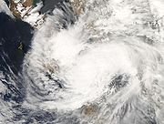
Tropical Storm Julio was a tropical storm
that made landfall on the southern tip of Baja California Sur
in August 2008. The tenth named storm of the 2008 Pacific hurricane season
, it developed from a tropical wave
on August 23 off the coast of Mexico. It moved parallel to the coast, reaching peak winds of 50 mph (85 km/h) before moving ashore and weakening. On August 26 it dissipated in the Gulf of California
. Julio was the third tropical cyclone to make landfall in the Pacific Ocean basin during the season, after Tropical Storm Alma
, which struck Nicaragua
in May, and Tropical Depression Five-E, which moved ashore along southwestern Mexico in July. The storm brought locally heavy rainfall to southern Baja California, killing one person and leaving several towns isolated. Moisture from Julio reached Arizona
, producing thunderstorms, including one which damaged ten small planes in Chandler
.
became discernible about 800 miles (1300 km) off the coast of Mexico
, which in the next day developed a large area of convection
, or thunderstorms. Initially, conditions were unfavorable for development
, due to strong upper-level wind shear
. Tracking northwestward parallel to the Mexican coast, the system became better organized on August 22, though later that day its structure deteriorated. On August 23, a strong area of convection developed and persisted near a circulation center
, despite strong wind shear. With banding features becoming more prominent, the National Hurricane Center
(NHC) classified the system as Tropical Depression Eleven-E about 345 miles (555 km) south-southeast of the southern tip of the Baja California Peninsula
.
 The tropical depression
initially moved northwestward around the southwestern periphery of a ridge
over Mexico. Convection continued to develop to the west of the center, and late on August 23, a ship report confirmed the depression intensified Tropical Storm Julio. Initially, the persistent shear left the center partially exposed from the thunderstorm activity, though upper level conditions gradually became more favorable for strengthening. On August 24, Tropical Storm Julio attained peak winds of 50 mph (85 km/h) as intense convection developed near the center. Shortly thereafter, the center became difficult to locate, and late on August 24 the storm moved ashore along the southwestern coast of the Baja California Peninsula.
Tropical Storm Julio quickly weakened over land, although it initially maintained strong convection near its center. By early on August 26, however, the low-level and upper-level circulations separated, with the upper-circulation continuing quickly northeastward into mainland Mexico; the low-level circulation slowed as it entered the Gulf of California
, after having been separated from its deep convection. Later in the day, the NHC discontinued advisories after the storm failed to maintain enough organized convection to be considered a tropical cyclone.
issued a tropical storm watch
in the state of Baja California Sur
, from Santa Fe on the Pacific coast around the peninsula to Buenavista along the Gulf of California
. About 24 hours prior to landfall, the watch was replaced with a warning from Santa Fe to San Evaristo, and the tropical storm watch was extended along both sides of the peninsula. Prior to it making landfall, more than 2,500 families in susceptible areas left their homes. Officials opened several shelters in the area where the storm struck.
As Julio made landfall, it produced lightning and locally heavy rainfall, which left more than a dozen communities isolated due to flooding. The flooding damaged several houses and killed two people. Winds were generally light, although strong enough to damage a few electrical poles and small buildings. In nearby Sinaloa
, rainfall from the storm led to an emergency evacuation of 500 residents.
Moisture from Julio developed thunderstorms across Arizona
, including one near Chandler
which produced winds of 75 mph (120 km/h); the storm damaged ten small planes at Chandler Municipal Airport
, as well as a hangar. The damages at the airport were estimated at $1 million (USD
). The storms also dropped heavy rainfall, reaching over 1 inch (25 mm) in Gilbert
, which caused flooding on Interstate 17
.
Tropical cyclone
A tropical cyclone is a storm system characterized by a large low-pressure center and numerous thunderstorms that produce strong winds and heavy rain. Tropical cyclones strengthen when water evaporated from the ocean is released as the saturated air rises, resulting in condensation of water vapor...
that made landfall on the southern tip of Baja California Sur
Baja California Sur
Baja California Sur , is one of the 31 states which, with the Federal District, comprise the 32 Federal Entities of Mexico. Before becoming a state on October 8, 1974, the area was known as the South Territory of Baja California. It has an area of , or 3.57% of the land mass of Mexico and comprises...
in August 2008. The tenth named storm of the 2008 Pacific hurricane season
2008 Pacific hurricane season
The 2008 Pacific hurricane season was an event in the annual cycle of tropical cyclone formation. It officially started May 15, 2008 in the eastern Pacific, started on June 1, 2008 in the central Pacific, and lasted until November 30, 2008....
, it developed from a tropical wave
Tropical wave
Tropical waves, easterly waves, or tropical easterly waves, also known as African easterly waves in the Atlantic region, are a type of atmospheric trough, an elongated area of relatively low air pressure, oriented north to south, which move from east to west across the tropics causing areas of...
on August 23 off the coast of Mexico. It moved parallel to the coast, reaching peak winds of 50 mph (85 km/h) before moving ashore and weakening. On August 26 it dissipated in the Gulf of California
Gulf of California
The Gulf of California is a body of water that separates the Baja California Peninsula from the Mexican mainland...
. Julio was the third tropical cyclone to make landfall in the Pacific Ocean basin during the season, after Tropical Storm Alma
Tropical Storm Alma
Tropical Storm Alma of the 2008 Pacific hurricane season was the easternmost forming Pacific tropical cyclone on record and the first tropical storm on record to strike the Pacific coast of Nicaragua. In the spring of 2009, the WMO retired the name Alma and replaced it with Amanda for use in the...
, which struck Nicaragua
Nicaragua
Nicaragua is the largest country in the Central American American isthmus, bordered by Honduras to the north and Costa Rica to the south. The country is situated between 11 and 14 degrees north of the Equator in the Northern Hemisphere, which places it entirely within the tropics. The Pacific Ocean...
in May, and Tropical Depression Five-E, which moved ashore along southwestern Mexico in July. The storm brought locally heavy rainfall to southern Baja California, killing one person and leaving several towns isolated. Moisture from Julio reached Arizona
Arizona
Arizona ; is a state located in the southwestern region of the United States. It is also part of the western United States and the mountain west. The capital and largest city is Phoenix...
, producing thunderstorms, including one which damaged ten small planes in Chandler
Chandler, Arizona
-Demographics:As of the Census of 2010, there were 236,123 people, 86,924 households, and 60,212 families residing in the city. The racial makeup of the city was 73.3% White, 4.8% Black or African American, 1.5% Native American, 8.2% Asian, 0.2% Pacific Islander, 21.9% Hispanic or Latino, and 8.3%...
.
Meteorological history
On August 20, a tropical waveTropical wave
Tropical waves, easterly waves, or tropical easterly waves, also known as African easterly waves in the Atlantic region, are a type of atmospheric trough, an elongated area of relatively low air pressure, oriented north to south, which move from east to west across the tropics causing areas of...
became discernible about 800 miles (1300 km) off the coast of Mexico
Mexico
The United Mexican States , commonly known as Mexico , is a federal constitutional republic in North America. It is bordered on the north by the United States; on the south and west by the Pacific Ocean; on the southeast by Guatemala, Belize, and the Caribbean Sea; and on the east by the Gulf of...
, which in the next day developed a large area of convection
Atmospheric convection
Atmospheric convection is the result of a parcel-environment instability, or temperature difference, layer in the atmosphere. Different lapse rates within dry and moist air lead to instability. Mixing of air during the day which expands the height of the planetary boundary layer leads to...
, or thunderstorms. Initially, conditions were unfavorable for development
Tropical cyclogenesis
Tropical cyclogenesis is the term that describes the development and strengthening of a tropical cyclone in the atmosphere. The mechanisms through which tropical cyclogenesis occurs are distinctly different from those through which mid-latitude cyclogenesis occurs...
, due to strong upper-level wind shear
Wind shear
Wind shear, sometimes referred to as windshear or wind gradient, is a difference in wind speed and direction over a relatively short distance in the atmosphere...
. Tracking northwestward parallel to the Mexican coast, the system became better organized on August 22, though later that day its structure deteriorated. On August 23, a strong area of convection developed and persisted near a circulation center
Atmospheric circulation
Atmospheric circulation is the large-scale movement of air, and the means by which thermal energy is distributed on the surface of the Earth....
, despite strong wind shear. With banding features becoming more prominent, the National Hurricane Center
National Hurricane Center
The National Hurricane Center , located at Florida International University in Miami, Florida, is the division of the National Weather Service responsible for tracking and predicting weather systems within the tropics between the Prime Meridian and the 140th meridian west poleward to the 30th...
(NHC) classified the system as Tropical Depression Eleven-E about 345 miles (555 km) south-southeast of the southern tip of the Baja California Peninsula
Baja California Peninsula
The Baja California peninsula , is a peninsula in northwestern Mexico. Its land mass separates the Pacific Ocean from the Gulf of California. The Peninsula extends from Mexicali, Baja California in the north to Cabo San Lucas, Baja California Sur in the south.The total area of the Baja California...
.
Tropical cyclone scales
Tropical systems are officially ranked on one of several tropical cyclone scales according to their maximum sustained winds and in what oceanic basin they are located...
initially moved northwestward around the southwestern periphery of a ridge
Ridge (meteorology)
A ridge is an elongated region of relatively high atmospheric pressure, the opposite of a trough....
over Mexico. Convection continued to develop to the west of the center, and late on August 23, a ship report confirmed the depression intensified Tropical Storm Julio. Initially, the persistent shear left the center partially exposed from the thunderstorm activity, though upper level conditions gradually became more favorable for strengthening. On August 24, Tropical Storm Julio attained peak winds of 50 mph (85 km/h) as intense convection developed near the center. Shortly thereafter, the center became difficult to locate, and late on August 24 the storm moved ashore along the southwestern coast of the Baja California Peninsula.
Tropical Storm Julio quickly weakened over land, although it initially maintained strong convection near its center. By early on August 26, however, the low-level and upper-level circulations separated, with the upper-circulation continuing quickly northeastward into mainland Mexico; the low-level circulation slowed as it entered the Gulf of California
Gulf of California
The Gulf of California is a body of water that separates the Baja California Peninsula from the Mexican mainland...
, after having been separated from its deep convection. Later in the day, the NHC discontinued advisories after the storm failed to maintain enough organized convection to be considered a tropical cyclone.
Preparations and impact
Shortly before it was named, the government of MexicoMexico
The United Mexican States , commonly known as Mexico , is a federal constitutional republic in North America. It is bordered on the north by the United States; on the south and west by the Pacific Ocean; on the southeast by Guatemala, Belize, and the Caribbean Sea; and on the east by the Gulf of...
issued a tropical storm watch
Tropical cyclone warnings and watches
Warnings and watches are two levels of alert issued by national weather forecasting bodies to coastal areas threatened by the imminent approach of a tropical cyclone of tropical storm or hurricane intensity. They are notices to the local population and civil authorities to make appropriate...
in the state of Baja California Sur
Baja California Sur
Baja California Sur , is one of the 31 states which, with the Federal District, comprise the 32 Federal Entities of Mexico. Before becoming a state on October 8, 1974, the area was known as the South Territory of Baja California. It has an area of , or 3.57% of the land mass of Mexico and comprises...
, from Santa Fe on the Pacific coast around the peninsula to Buenavista along the Gulf of California
Gulf of California
The Gulf of California is a body of water that separates the Baja California Peninsula from the Mexican mainland...
. About 24 hours prior to landfall, the watch was replaced with a warning from Santa Fe to San Evaristo, and the tropical storm watch was extended along both sides of the peninsula. Prior to it making landfall, more than 2,500 families in susceptible areas left their homes. Officials opened several shelters in the area where the storm struck.
As Julio made landfall, it produced lightning and locally heavy rainfall, which left more than a dozen communities isolated due to flooding. The flooding damaged several houses and killed two people. Winds were generally light, although strong enough to damage a few electrical poles and small buildings. In nearby Sinaloa
Sinaloa
Sinaloa officially Estado Libre y Soberano de Sinaloa is one of the 31 states which, with the Federal District, comprise the 32 Federal Entities of Mexico. It is divided in 18 municipalities and its capital city is Culiacán Rosales....
, rainfall from the storm led to an emergency evacuation of 500 residents.
Moisture from Julio developed thunderstorms across Arizona
Arizona
Arizona ; is a state located in the southwestern region of the United States. It is also part of the western United States and the mountain west. The capital and largest city is Phoenix...
, including one near Chandler
Chandler, Arizona
-Demographics:As of the Census of 2010, there were 236,123 people, 86,924 households, and 60,212 families residing in the city. The racial makeup of the city was 73.3% White, 4.8% Black or African American, 1.5% Native American, 8.2% Asian, 0.2% Pacific Islander, 21.9% Hispanic or Latino, and 8.3%...
which produced winds of 75 mph (120 km/h); the storm damaged ten small planes at Chandler Municipal Airport
Chandler Municipal Airport
Chandler Municipal Airport is a city-owned public-use airport located three miles southeast of the central business district of Chandler, a city in Maricopa County, Arizona, United States.Although most U.S...
, as well as a hangar. The damages at the airport were estimated at $1 million (USD
United States dollar
The United States dollar , also referred to as the American dollar, is the official currency of the United States of America. It is divided into 100 smaller units called cents or pennies....
). The storms also dropped heavy rainfall, reaching over 1 inch (25 mm) in Gilbert
Gilbert, Arizona
-Demographics:As of July 1, 2009, Maricopa Association of Governments, Census 2000. United States Census Bureau. there were 217,521 people, 74,147 housing units, and 3.01 persons per household....
, which caused flooding on Interstate 17
Interstate 17
Interstate 17 , also known as the Black Canyon Freeway, is an intrastate Interstate Highway located entirely within the state of Arizona, United States. I-17's southern terminus lies within Phoenix, at Interstate 10, and its northern terminus is in Flagstaff, at Interstate 40...
.
See also
- List of Pacific hurricanes
- Other tropical cyclones named Julio
- Timeline of the 2008 Pacific hurricane seasonTimeline of the 2008 Pacific hurricane seasonBelow is the Timeline of the 2008 Pacific hurricane season, documenting all the storm formations, strengthening, weakening, landfalls, extratropical transitions, as well as dissipation. The 2008 Pacific hurricane season officially began on May 15, 2008, and will last until November 30. For...