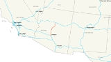
Interstate 17 also known as the
Black Canyon Freeway, is an
intrastate Interstate Highway located entirely within the state of
ArizonaArizona ; is a state located in the southwestern region of the United States. It is also part of the western United States and the mountain west. The capital and largest city is Phoenix...
, United States. I-17's southern terminus lies within
PhoenixPhoenix is the capital, and largest city, of the U.S. state of Arizona, as well as the sixth most populated city in the United States. Phoenix is home to 1,445,632 people according to the official 2010 U.S. Census Bureau data...
, at
Interstate 10In the U.S. state of Arizona, Interstate 10, the major east–west Interstate Highway in the southern United States, runs east from California, enters Arizona and continues through Phoenix and Tucson and exits at the border with New Mexico.-Route description:...
, and its northern terminus is in
FlagstaffFlagstaff is a city located in northern Arizona, in the southwestern United States. In 2010, the city's population was 65,870. The population of the Metropolitan Statistical Area was at 134,421 in 2010. It is the county seat of Coconino County...
, at
Interstate 40Interstate 40 is an east–west Interstate Highway that has a section in the U.S. state of Arizona connecting sections in California to New Mexico. It enters Arizona from the west at a crossing of the Colorado River southwest of Kingman...
. The southern part of the freeway was built along the alignment of SR 69, while the northern part was built along SR 79's alignment. I-17 is one of the more scenic Interstate Highways as it gains more than a mile in altitude between Phoenix (1,117 ft) and Flagstaff (7,000 ft). The highway features several scenic view exits along its route that overlook the many mountains and valleys found in northern Arizona.
Route description
Interstate 17 is known as the Black Canyon Freeway from the northern end of the
Phoenix Metropolitan AreaThe Phoenix metropolitan area, often referred to as The Valley of the Sun, is a metropolitan area, centered on the city of Phoenix, that includes much of the central part of the US state of Arizona...
to its first interchange with
Interstate 10In the U.S. state of Arizona, Interstate 10, the major east–west Interstate Highway in the southern United States, runs east from California, enters Arizona and continues through Phoenix and Tucson and exits at the border with New Mexico.-Route description:...
northwest of
Downtown PhoenixDowntown Phoenix is the central business district of Phoenix, Arizona, United States. It is located near the geographic center of the Phoenix metropolitan area or Valley of the Sun. Phoenix, being the county seat of Maricopa County and the capital of Arizona, serves as the center of politics,...
, which is known as
The StackThe Stack is a colloquialism used to describe the symmetrical, four-level stack interchange in Downtown Phoenix in the U.S. state of Arizona that facilitates movements between Interstate 17/U.S...
. At the curve southwest of downtown, between the 19th Avenue and Buckeye Road interchanges, it picks up the designation Maricopa Freeway all the way to the southern terminus at the second
Interstate 10In the U.S. state of Arizona, Interstate 10, the major east–west Interstate Highway in the southern United States, runs east from California, enters Arizona and continues through Phoenix and Tucson and exits at the border with New Mexico.-Route description:...
junction. It is one of the metropolitan area's primary freeways.
I-17 has the unusual distinction of starting at approximately milepost 194 instead of at milepost zero. This is a holdover from Arizona's old system of marking mileposts, where a branching route would continue the milepost numbering of its original host instead of starting over at zero. Interstate 17 inherited its milepost locations from SR 69, which the freeway replaced between Phoenix and Cordes Junction. SR 69's mileposting was such that it coincided with US 89's mileposting, which was 201.6 where the two routes intersected. When I-17 was constructed, the existing mileposting for SR 69 was retained.
History
In 1936, SR 69 was established as a state route from Phoenix north to
PrescottPrescott is a city in Yavapai County, Arizona, USA. It was designated "Arizona's Christmas City" by Arizona Governor Rose Mofford in the late 1980s....
. The road was completed by 1940 to Prescott. In 1954, a new route north to Flagstaff was established as SR 79. By 1961, the roadway from Phoenix to Flagstaff had been established, but not to Interstate standards. By 1971, I-17 had been completed from Phoenix northward to Camp Verde where a short stretch had not been completed to standards. The stretch from SR 279 north to SR 179 was also complete. The largest section yet to be completed was from SR 179 north to Flagstaff. This segment was still just a two-lane roadway, but it did have full traffic interchanges built at cross roads. The portion from I-40 south to the Flagstaff Municipal Airport had been completed by this time.
Exit list
External links