
.gif)
Tropical Storm Emilia (2006)
Encyclopedia
Tropical Storm Emilia was a rare tropical cyclone
that affected the Baja California peninsula
in July 2006. The sixth tropical depression and fifth tropical storm of the 2006 Pacific hurricane season
, it developed on July 21 about 400 miles (650 km) off the coast of Mexico
. It moved northward toward the coast, reaching peak winds of 65 mph (105 km/h) before turning westward and encountering unfavorable conditions. Emilia later turned to the north, passing near Baja California as a strong tropical storm. Subsequently the storm moved further away from the coast, and on July 27 it dissipated.
The storm brought tropical storm force winds and precipitation to the southwestern Mexican coastline. Later, Emilia produced similar conditions in the southern portion of the Baja California peninsula, where its passage caused minor damage and flooding. Moisture from Emilia reached the southwestern United States, producing thunderstorms and flash flooding in Arizona, as well as beneficial rainfall in southern California. No deaths were reported in association with Emilia.
that crossed northern Central America
into the eastern Pacific Ocean
on July 16. The system moved westward, developing a well-defined low pressure area
about 525 miles (850 km) southwest of Acapulco
by July 19. The next day, its forward motion had shifted to a slow north-northwest track, and with its convection
continuing to organize around the low, the National Hurricane Center
(NHC) remarked on the potential for tropical cyclogenesis
. Early on July 21, its thunderstorm activity organized enough for the NHC to classify it as Tropical Depression Six-E, located to the southwest of Acapulco.
Upon becoming a tropical cyclone, the depression existed in an area of weak steering currents, though a general motion to the north-northwest was influenced by a large subtropical ridge
over the southwest United States. The circulation was initially located east of the main convection, due to the presence of wind shear
. Convection increased near the center despite the shear, and on July 22 the depression attained tropical storm status about 400 mi (650 km) south of Manzanillo, Colima
; it was named Emilia by the NHC. Around the same time, the storm was developing better-defined rainbands, and with favorable conditions expected, Emilia was forecast to attain hurricane status; the NHC noted the potential for rapid deepening
as the storm passed near southwestern Mexico.
Early on July 23, the storm briefly became disorganized, with the low-level circulation becoming ill-defined. Around the same time, Emilia passed about 175 mi (280 km) southwest of Manzanillo, which was its closest approach to southwestern Mexico; it is believed to have caused tropical storm force wind gusts along the coastline. Later that day, after turning west-northwestward, the convection increased markedly as an eyewall
began to form. Operationally, it was estimated to have reached winds of 70 mph (115 km/h), and it was forecast to continue strengthening to attain Category 2 status on the Saffir-Simpson scale
. However, the NHC later re-assessed Emilia as reaching peak winds of 65 mph (105 km/h), since the eye feature was temporary and not well-defined.
Shortly after reaching peak intensity, a sharp increase in wind shear caused Emilia to weaken quickly to winds of 50 mph (85 km/h). Operationally, the NHC initially continued to assess the storm as with winds of 70 mph (115 m/h), with hurricane status predicted. However, the decrease in strength became evident on July 24, when dry air became entrained in the circulation; at the same time, the convection became limited to the southern semicircle of the storm. On July 25, the wind shear decreased as the storm turned toward the Baja California peninsula
, despite that tropical cyclones affecting the Baja California peninsula
in the month of July are rare. Convection increased in coverage, and an eye feature re-appeared early on July 26 as it again attained peak winds of 65 mph (105 km/h).
Emilia maintained peak winds for about 18 hours, during which it passed about 60 mi (95 km) southwest of Cabo San Lazaro, which is a cape located southwest of Ciudad Constitución
on the southwestern coast of the Baja California peninsula. After brushing the peninsula with its outer rainbands, Emilia turned away from the coast into cooler waters, and subsequently began to weaken rapidly. On July 27 it deteriorated into a tropical depression, and the next day Emilia degenerated into a convective-less remnant low. The low continued westward until turning northward on July 30, and on July 31 the remnants of Emilia dissipated about 495 mi (800 km) west-southwest of San Diego, California
.
 As Emilia first approached the southwest coast of Mexico
, officials issued a tropical storm watch
from Manzanillo
to Cabo Corrientes
, Jalisco
; the watch was discontinued 30 hours after it was issued. The storm passed the region on July 22, and is believed to have produced tropical storm force wind gusts along the coastline. A ship recorded 40 mph (65 km/h) winds while Emilia was just off the coast. Further up the coast, in Mazatlán
, strong waves from the storm caused beaches to close, while the outer fringes of the storm dropped 4.68 inches (119 mm) of precipitation. Inland, the interaction between Emilia and a tropical wave brought increased moisture and precipitation to southeastern and central Mexico.
 When Emilia began turning toward the Baja California peninsula
, the government of Mexico issued a tropical storm watch from Buena Vista along the Gulf of California
to Bahía Magdalena
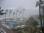
along the Pacific coast. The watch was replaced with a tropical storm warning about 12 hours prior to the closest approach of the storm, and additional warnings were issued along the Pacific coastline as the storm passed. All watches and warnings were discontinued by July 27. Officials prepared two schools as emergency shelters in Cabo San Lucas, where 100 people stayed during the storm. In the area, the threat of the storm resulted in the closure of several bars and restaurants.
Across the southern portion of the Baja California peninsula, the storm dropped moderate rainfall, with a total of about 5 inches (125 mm) reported in Cabo San Lucas
; the NHC remarked that higher amounts likely occurred in higher elevations. The rainfall caused minor flooding in and around Cabo San Lucas. Along the southern coast of the peninsula, Emilia produced tropical storm force winds; two stations reported sustained winds of 43 mph (69 km/h), with one of those reporting wind gusts to 55 mph (89 km/h). The storm caused minor damage to buildings and utility lines. Waves from the storm left minor damage at several marinas in the region, with several being closed for two days.
The effects of Emilia reached the southwestern United States. In southern Arizona, a surge of moisture from the storm produced scattered thunderstorms, including one severe thunderstorm in Santa Cruz County
. The cell dropped heavy rainfall and large hailstones in a short amount of time; one location reported hail of 1.75 inches (44.5 mm) in diameter. The rainfall, which totaled several inches in some areas, caused flash flood
ing, with 8 inches (205 mm) of floodwater reported at one location along Interstate 19
. Thunderstorms in Graham County
produced a wind gust of 64 mph (103 km/h) at the airport in Safford
. Unsettled conditions persisted across Arizona for about a week. In southern California, the storm dropped light rainfall, which assisted firefighters in containing a wildfire.
Tropical cyclone
A tropical cyclone is a storm system characterized by a large low-pressure center and numerous thunderstorms that produce strong winds and heavy rain. Tropical cyclones strengthen when water evaporated from the ocean is released as the saturated air rises, resulting in condensation of water vapor...
that affected the Baja California peninsula
Baja California Peninsula
The Baja California peninsula , is a peninsula in northwestern Mexico. Its land mass separates the Pacific Ocean from the Gulf of California. The Peninsula extends from Mexicali, Baja California in the north to Cabo San Lucas, Baja California Sur in the south.The total area of the Baja California...
in July 2006. The sixth tropical depression and fifth tropical storm of the 2006 Pacific hurricane season
2006 Pacific hurricane season
The 2006 Pacific hurricane season was the most active Pacific hurricane season since 2000 producing 19 tropical storms or hurricanes. Eighteen developed within the National Hurricane Center area of warning responsibility, which is east of 140ºW, and one storm formed between 140ºW and the...
, it developed on July 21 about 400 miles (650 km) off the coast of Mexico
Mexico
The United Mexican States , commonly known as Mexico , is a federal constitutional republic in North America. It is bordered on the north by the United States; on the south and west by the Pacific Ocean; on the southeast by Guatemala, Belize, and the Caribbean Sea; and on the east by the Gulf of...
. It moved northward toward the coast, reaching peak winds of 65 mph (105 km/h) before turning westward and encountering unfavorable conditions. Emilia later turned to the north, passing near Baja California as a strong tropical storm. Subsequently the storm moved further away from the coast, and on July 27 it dissipated.
The storm brought tropical storm force winds and precipitation to the southwestern Mexican coastline. Later, Emilia produced similar conditions in the southern portion of the Baja California peninsula, where its passage caused minor damage and flooding. Moisture from Emilia reached the southwestern United States, producing thunderstorms and flash flooding in Arizona, as well as beneficial rainfall in southern California. No deaths were reported in association with Emilia.
Meteorological history
The origins of Emilia can be traced to a tropical waveTropical wave
Tropical waves, easterly waves, or tropical easterly waves, also known as African easterly waves in the Atlantic region, are a type of atmospheric trough, an elongated area of relatively low air pressure, oriented north to south, which move from east to west across the tropics causing areas of...
that crossed northern Central America
Central America
Central America is the central geographic region of the Americas. It is the southernmost, isthmian portion of the North American continent, which connects with South America on the southeast. When considered part of the unified continental model, it is considered a subcontinent...
into the eastern Pacific Ocean
Pacific Ocean
The Pacific Ocean is the largest of the Earth's oceanic divisions. It extends from the Arctic in the north to the Southern Ocean in the south, bounded by Asia and Australia in the west, and the Americas in the east.At 165.2 million square kilometres in area, this largest division of the World...
on July 16. The system moved westward, developing a well-defined low pressure area
Low pressure area
A low-pressure area, or "low", is a region where the atmospheric pressure at sea level is below that of surrounding locations. Low-pressure systems form under areas of wind divergence which occur in upper levels of the troposphere. The formation process of a low-pressure area is known as...
about 525 miles (850 km) southwest of Acapulco
Acapulco
Acapulco is a city, municipality and major sea port in the state of Guerrero on the Pacific coast of Mexico, southwest from Mexico City. Acapulco is located on a deep, semi-circular bay and has been a port since the early colonial period of Mexico’s history...
by July 19. The next day, its forward motion had shifted to a slow north-northwest track, and with its convection
Atmospheric convection
Atmospheric convection is the result of a parcel-environment instability, or temperature difference, layer in the atmosphere. Different lapse rates within dry and moist air lead to instability. Mixing of air during the day which expands the height of the planetary boundary layer leads to...
continuing to organize around the low, the National Hurricane Center
National Hurricane Center
The National Hurricane Center , located at Florida International University in Miami, Florida, is the division of the National Weather Service responsible for tracking and predicting weather systems within the tropics between the Prime Meridian and the 140th meridian west poleward to the 30th...
(NHC) remarked on the potential for tropical cyclogenesis
Tropical cyclogenesis
Tropical cyclogenesis is the term that describes the development and strengthening of a tropical cyclone in the atmosphere. The mechanisms through which tropical cyclogenesis occurs are distinctly different from those through which mid-latitude cyclogenesis occurs...
. Early on July 21, its thunderstorm activity organized enough for the NHC to classify it as Tropical Depression Six-E, located to the southwest of Acapulco.
Upon becoming a tropical cyclone, the depression existed in an area of weak steering currents, though a general motion to the north-northwest was influenced by a large subtropical ridge
Subtropical ridge
The subtropical ridge is a significant belt of high pressure situated around the latitudes of 30°N in the Northern Hemisphere and 30°S in the Southern Hemisphere. It is characterized by mostly calm winds, which acts to reduce air quality under its axis by causing fog overnight, and haze during...
over the southwest United States. The circulation was initially located east of the main convection, due to the presence of wind shear
Wind shear
Wind shear, sometimes referred to as windshear or wind gradient, is a difference in wind speed and direction over a relatively short distance in the atmosphere...
. Convection increased near the center despite the shear, and on July 22 the depression attained tropical storm status about 400 mi (650 km) south of Manzanillo, Colima
Manzanillo, Colima
The name Manzanillo refers to the city as well as its surrounding municipality in the Mexican state of Colima. The city, located on the Pacific Ocean, contains Mexico's busiest port. Manzanillo was the third port created by the Spanish in the Pacific during the New Spain period...
; it was named Emilia by the NHC. Around the same time, the storm was developing better-defined rainbands, and with favorable conditions expected, Emilia was forecast to attain hurricane status; the NHC noted the potential for rapid deepening
Rapid deepening
Rapid deepening, also known as rapid intensification, is a meteorological condition that occurs when the minimum sea-level atmospheric pressure of a tropical cyclone decreases drastically in a short period of time. The National Weather Service describes rapid deepening as a decrease of...
as the storm passed near southwestern Mexico.
Early on July 23, the storm briefly became disorganized, with the low-level circulation becoming ill-defined. Around the same time, Emilia passed about 175 mi (280 km) southwest of Manzanillo, which was its closest approach to southwestern Mexico; it is believed to have caused tropical storm force wind gusts along the coastline. Later that day, after turning west-northwestward, the convection increased markedly as an eyewall
Eye (cyclone)
The eye is a region of mostly calm weather found at the center of strong tropical cyclones. The eye of a storm is a roughly circular area and typically 30–65 km in diameter. It is surrounded by the eyewall, a ring of towering thunderstorms where the second most severe weather of a cyclone...
began to form. Operationally, it was estimated to have reached winds of 70 mph (115 km/h), and it was forecast to continue strengthening to attain Category 2 status on the Saffir-Simpson scale
Saffir-Simpson Hurricane Scale
The Saffir–Simpson Hurricane Scale , or the Saffir–Simpson Hurricane Wind Scale , classifies hurricanes — Western Hemisphere tropical cyclones that exceed the intensities of tropical depressions and tropical storms — into five categories distinguished by the intensities of their sustained winds...
. However, the NHC later re-assessed Emilia as reaching peak winds of 65 mph (105 km/h), since the eye feature was temporary and not well-defined.
Shortly after reaching peak intensity, a sharp increase in wind shear caused Emilia to weaken quickly to winds of 50 mph (85 km/h). Operationally, the NHC initially continued to assess the storm as with winds of 70 mph (115 m/h), with hurricane status predicted. However, the decrease in strength became evident on July 24, when dry air became entrained in the circulation; at the same time, the convection became limited to the southern semicircle of the storm. On July 25, the wind shear decreased as the storm turned toward the Baja California peninsula
Baja California Peninsula
The Baja California peninsula , is a peninsula in northwestern Mexico. Its land mass separates the Pacific Ocean from the Gulf of California. The Peninsula extends from Mexicali, Baja California in the north to Cabo San Lucas, Baja California Sur in the south.The total area of the Baja California...
, despite that tropical cyclones affecting the Baja California peninsula
Baja California Peninsula
The Baja California peninsula , is a peninsula in northwestern Mexico. Its land mass separates the Pacific Ocean from the Gulf of California. The Peninsula extends from Mexicali, Baja California in the north to Cabo San Lucas, Baja California Sur in the south.The total area of the Baja California...
in the month of July are rare. Convection increased in coverage, and an eye feature re-appeared early on July 26 as it again attained peak winds of 65 mph (105 km/h).
Emilia maintained peak winds for about 18 hours, during which it passed about 60 mi (95 km) southwest of Cabo San Lazaro, which is a cape located southwest of Ciudad Constitución
Ciudad Constitución
Ciudad Constitución is a city in the Mexican state of Baja California Sur. It is the seat of the municipality of Comondú and is located 210 kilometers north of La Paz, Baja California Sur, and 147 kilometers south of Loreto, Baja California Sur. Ciudad Constitución's population was 40,935...
on the southwestern coast of the Baja California peninsula. After brushing the peninsula with its outer rainbands, Emilia turned away from the coast into cooler waters, and subsequently began to weaken rapidly. On July 27 it deteriorated into a tropical depression, and the next day Emilia degenerated into a convective-less remnant low. The low continued westward until turning northward on July 30, and on July 31 the remnants of Emilia dissipated about 495 mi (800 km) west-southwest of San Diego, California
San Diego, California
San Diego is the eighth-largest city in the United States and second-largest city in California. The city is located on the coast of the Pacific Ocean in Southern California, immediately adjacent to the Mexican border. The birthplace of California, San Diego is known for its mild year-round...
.
Preparations and impact
Mexico
The United Mexican States , commonly known as Mexico , is a federal constitutional republic in North America. It is bordered on the north by the United States; on the south and west by the Pacific Ocean; on the southeast by Guatemala, Belize, and the Caribbean Sea; and on the east by the Gulf of...
, officials issued a tropical storm watch
Tropical cyclone warnings and watches
Warnings and watches are two levels of alert issued by national weather forecasting bodies to coastal areas threatened by the imminent approach of a tropical cyclone of tropical storm or hurricane intensity. They are notices to the local population and civil authorities to make appropriate...
from Manzanillo
Manzanillo, Colima
The name Manzanillo refers to the city as well as its surrounding municipality in the Mexican state of Colima. The city, located on the Pacific Ocean, contains Mexico's busiest port. Manzanillo was the third port created by the Spanish in the Pacific during the New Spain period...
to Cabo Corrientes
Cabo Corrientes
Cabo Corrientes is a cape on the Pacific coast of the Mexican state of Jalisco. It marks the southernmost point of the Bahía de Banderas, upon which the port and resort city of Puerto Vallarta stands. The municipality in which the cape lies is also called Cabo Corrientes.Cabo Corrientes is a...
, Jalisco
Jalisco
Jalisco officially Estado Libre y Soberano de Jalisco is one of the 31 states which, with the Federal District, comprise the 32 Federal Entities of Mexico. It is located in Western Mexico and divided in 125 municipalities and its capital city is Guadalajara.It is one of the more important states...
; the watch was discontinued 30 hours after it was issued. The storm passed the region on July 22, and is believed to have produced tropical storm force wind gusts along the coastline. A ship recorded 40 mph (65 km/h) winds while Emilia was just off the coast. Further up the coast, in Mazatlán
Mazatlán
Mazatlán is a city in the Mexican state of Sinaloa; the surrounding municipio for which the city serves as the municipal seat is Mazatlán Municipality. It is located at on the Pacific coast, across from the southernmost tip of the Baja California peninsula.Mazatlán is a Nahuatl word meaning...
, strong waves from the storm caused beaches to close, while the outer fringes of the storm dropped 4.68 inches (119 mm) of precipitation. Inland, the interaction between Emilia and a tropical wave brought increased moisture and precipitation to southeastern and central Mexico.
Baja California Peninsula
The Baja California peninsula , is a peninsula in northwestern Mexico. Its land mass separates the Pacific Ocean from the Gulf of California. The Peninsula extends from Mexicali, Baja California in the north to Cabo San Lucas, Baja California Sur in the south.The total area of the Baja California...
, the government of Mexico issued a tropical storm watch from Buena Vista along the Gulf of California
Gulf of California
The Gulf of California is a body of water that separates the Baja California Peninsula from the Mexican mainland...
to Bahía Magdalena
Magdalena Bay
Bahía Magdalena is a 50 km long bay in Comondú Municipality along the western coast of the Mexican state of Baja California Sur. It is protected from the Pacific Ocean by the sandy barrier islands of Isla Magdalena and Isla Santa Margarita....
along the Pacific coast. The watch was replaced with a tropical storm warning about 12 hours prior to the closest approach of the storm, and additional warnings were issued along the Pacific coastline as the storm passed. All watches and warnings were discontinued by July 27. Officials prepared two schools as emergency shelters in Cabo San Lucas, where 100 people stayed during the storm. In the area, the threat of the storm resulted in the closure of several bars and restaurants.
Across the southern portion of the Baja California peninsula, the storm dropped moderate rainfall, with a total of about 5 inches (125 mm) reported in Cabo San Lucas
Cabo San Lucas
Cabo San Lucas , commonly called Cabo, is a city at the southern tip of the Baja California peninsula, in the municipality of Los Cabos in the Mexican state of Baja California Sur. As of the 2010 census, the population was 68,463 people...
; the NHC remarked that higher amounts likely occurred in higher elevations. The rainfall caused minor flooding in and around Cabo San Lucas. Along the southern coast of the peninsula, Emilia produced tropical storm force winds; two stations reported sustained winds of 43 mph (69 km/h), with one of those reporting wind gusts to 55 mph (89 km/h). The storm caused minor damage to buildings and utility lines. Waves from the storm left minor damage at several marinas in the region, with several being closed for two days.
The effects of Emilia reached the southwestern United States. In southern Arizona, a surge of moisture from the storm produced scattered thunderstorms, including one severe thunderstorm in Santa Cruz County
Santa Cruz County, Arizona
-2010:Whereas according to the 2010 U.S. Census Bureau:*73.5% White*0.4% Black*0.7% Native American*0.5% Asian*0.0% Native Hawaiian or Pacific Islander*2.0% Two or more races*22.9% Other races*82.8% Hispanic or Latino -2000:...
. The cell dropped heavy rainfall and large hailstones in a short amount of time; one location reported hail of 1.75 inches (44.5 mm) in diameter. The rainfall, which totaled several inches in some areas, caused flash flood
Flash flood
A flash flood is a rapid flooding of geomorphic low-lying areas—washes, rivers, dry lakes and basins. It may be caused by heavy rain associated with a storm, hurricane, or tropical storm or meltwater from ice or snow flowing over ice sheets or snowfields...
ing, with 8 inches (205 mm) of floodwater reported at one location along Interstate 19
Interstate 19
Interstate 19 is an intrastate Interstate Highway located entirely within the state of Arizona. I-19 runs from Nogales, roughly 1,500 feet from the Mexican border, to Tucson, at Interstate 10...
. Thunderstorms in Graham County
Graham County, Arizona
-2010:Whereas according to the 2010 U.S. Census Bureau:*72.1% White*1.8% Black*14.4% Native American*0.5% Asian*0.1% Native Hawaiian or Pacific Islander*2.8% Two or more races*8.3% Other races*30.4% Hispanic or Latino -2000:...
produced a wind gust of 64 mph (103 km/h) at the airport in Safford
Safford, Arizona
- History :Safford was founded by Joshua Eaton Bailey, Hiram Kennedy and Edward Tuttle, who came from Gila Bend, in southwestern Arizona. They left Gila Bend in the winter of 1873-74; their work on canals and dams having been destroyed by high water the previous summer...
. Unsettled conditions persisted across Arizona for about a week. In southern California, the storm dropped light rainfall, which assisted firefighters in containing a wildfire.
See also
- List of Baja California Peninsula hurricanes
- Other tropical cyclones named Emilia
- Timeline of the 2006 Pacific hurricane seasonTimeline of the 2006 Pacific hurricane seasonThe 2006 Pacific hurricane season was the most active since the 2000 season, producing produced 21 tropical depressions; 19 of which became tropical storms or hurricanes...
- List of storms in the 2006 Pacific hurricane season
External links
- The NHCNational Hurricane CenterThe National Hurricane Center , located at Florida International University in Miami, Florida, is the division of the National Weather Service responsible for tracking and predicting weather systems within the tropics between the Prime Meridian and the 140th meridian west poleward to the 30th...
's Tropical Storm Emilia