

Tipton County, Indiana
Encyclopedia
Tipton County is located in central Indiana
, north of the state capital of Indianapolis
. Before the arrival of non-indigenous settlers in the early 19th century, the area was inhabited by several Native American tribes. The county
was officially established in 1844 and was one of the last Indiana counties to be settled. The county seat
is Tipton
.
According to the 2010 census, the population was 15,936, a decrease of 3.9% from the 2000 population of 16,577. It is included in the Kokomo
, Indiana
, Metropolitan Statistical Area
. The county has four incorporated
towns with a total population of about 7,000, as well as many small unincorporated communities. It is divided into six townships which provide local services. Three Indiana state roads and one U.S. Route cross the county, as do two railroad lines.
and Delaware tribes.
Tipton County was formed in 1844. It was named for John Tipton
, a soldier of the Battle of Tippecanoe
in 1811. Tipton served as United States Senator for Indiana from 1831 until shortly before his death in 1839.
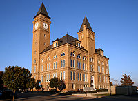
The present courthouse was designed by Adolph Sherrer. He had taken over the Indiana Statehouse project when architect Edwin May died in 1880; five years after the completion of that project in 1888, Scherrer began work on the Tipton building, which was built of sandstone in a Romanesque style with a clock tower that rises 206 feet above the ground, including the flagstaff on top. It was built by Pierce and Morgan of Indianapolis during 1893 and 1894 at a cost of $170,988. It is one of several Romanesque courthouses dating from the 1890s that are still in use.
, separates it from Indianapolis and Marion County
to the south. To the north lies Howard County
; to the west, Clinton County
; and to the east, Madison County
. A short portion of the eastern border, less than 2 miles (3.2 km) long, is shared with Grant County
to the northeast.
Most of the county consists of level till plain
with elevations from 850 feet (259.1 m) to 900 feet (274.3 m) above sea level. Prior to settlement by non-indigenous people, it was mostly covered with dense forests consisting of oak, beech, maple, walnut, hickory, sycamore and tulip trees. The southern part of the county has better natural drainage, and this area was first cleared for agriculture. Much of the rest of the county tended to be swampy due to the level ground and lack of sufficient natural waterways, so drainage channels had to be dug to make the land suitable for farming.
According to the 2010 census, the county has a total area of 260.57 square miles (674.9 km²), of which 260.54 square miles (674.8 km²) (or 99.99%) is land and 0.03 square mile (0.0776996433 km²) (or 0.01%) is water.
The county is divided into six townships: Cicero
, Jefferson
, Liberty
, Madison
, Prairie
and Wildcat
.
There are four incorporated settlements in the county. The largest is Tipton
. Located near the center of the county, it is the county seat; its population in 2000 was 5251. Kempton
is located near the western border in Jefferson Township and has a population of 380. The town of Sharpsville
is located near the northern border, in Liberty Township; its population is 618. Wildcat Township contains Windfall City
, which has a population of 712. The city of Elwood
lies in Madison County to the east and extends slightly over the border; as of the 2000 census, seven Elwood residents lived in Tipton County. The county also contains several unincorporated communities.
region of the United States along with most of Indiana. Its Köppen climate classification
is Dfa, meaning that it is cold, has no dry season, and has a hot summer. In recent years, average temperatures in Tipton have ranged from a low of 15 °F (-9.4 °C) in January to a high of 83 °F (28.3 °C) in July, although a record low of -25 °F was recorded in January 1994 and a record high of 98 °F (36.7 °C) was recorded in July 1999. Average monthly precipitation ranged from 1.67 inches (4.2 cm) in February to 4.24 inches (10.8 cm) in June. From 1950 through 2009, 13 tornadoes were reported in Tipton County, resulting in two deaths and several injuries; the total estimated property damage was over $3 million.
runs through the western part of the county, entering from Howard County and Kokomo
in the north and continuing to Hamilton County and Indianapolis in the south. Indiana State Road 19
and Indiana State Road 28
intersect in the county seat of Tipton. Indiana State Road 213
runs from north to south in the eastern part of the county, passing through the town of Windfall.
Though they do not run through the county, three other state roads touch its southeastern corner. Indiana State Road 13
and Indiana State Road 37
share the same route here while approaching Elwood. The point where they touch the corner of Tipton County is also the western terminus of Indiana State Road 128
.
Two Norfolk Southern Railway
routes run through the county. One line connects Muncie
in the east with Frankfort
in the west. The other connects Logansport
and Kokomo
in the north with Indianapolis in the south. The two lines intersect in Tipton.
was born in Tipton in 1882. He became a baseball pitcher, and aside from a single game played for the Saint Louis Cardinals in 1906, he played his entire Major League career with the Pittsburgh Pirates, and was known for his location control. His last Major League game was in 1926. He died in 1968 at age 86.
John Bunch
was born in Tipton in 1921 and became a jazz pianist. While still in his early teens, he was playing in local clubs, and went on to play with the bands of Woody Herman, Benny Goodman and Maynard Ferguson. He composed many original works, and continued playing in various roles through early 2010. He died in Manhattan soon after his last engagement; he was 88 years old.
and the Indiana Code
. The county council is the legislative branch of the county government and controls all spending and revenue collection. Representatives are elected from county districts. The council members serve four-year terms and are responsible for setting salaries, the annual budget and special spending. The council also has limited authority to impose local taxes, in the form of an income and property tax that is subject to state level approval, excise taxes and service taxes.
The executive body of the county is made of a board of commissioners. The commissioners are elected county-wide, in staggered terms, and each serves a four-year term. One of the commissioners, typically the most senior, serves as president. The commissioners are charged with executing the acts legislated by the council, collecting revenue and managing day-to-day functions of the county government.
The county maintains a small claims court
that can handle some civil cases. The judge on the court is elected to a term of four years and must be a member of the Indiana Bar Association. The judge is assisted by a constable who is elected to a four-year term. In some cases, court decisions can be appealed to the state level circuit court
.
The county has several other elected offices, including sheriff
, coroner
, auditor, treasurer
, recorder
, surveyor
and circuit court clerk
. Each of these elected officers serves a term of four years and oversees a different part of county government. Members elected to county government positions are required to declare party
affiliations and be residents of the county.
Each of the townships has a trustee who administers rural fire protection and ambulance service, provides poor relief and manages cemetery care, among other duties. The trustee is assisted in these duties by a three-member township board. The trustees and board members are elected to four-year terms.
Tipton County is part of Indiana's 5th congressional district
; Indiana Senate
districts 20 and 21; and Indiana House of Representatives
districts 32 and 35.
of 2000, there were 16,577 people, 6,469 households, and 4,748 families residing in the county. The population density
was 64 people per square mile (25/km²). There were 6,848 housing units at an average density of 26 per square mile (10/km²). The racial makeup of the county was 98.35% White
, 0.14% Black
or African American
, 0.22% Native American
, 0.30% Asian
, 0.01% Pacific Islander
, 0.33% from other races
, and 0.65% from two or more races. 1.21% of the population were Hispanic
or Latino
of any race. 33.1% were of American
, 22.8% German
, 12.7% English
and 7.3% Irish
ancestry according to Census 2000.
There were 6,469 households out of which 32.50% had children under the age of 18 living with them, 62.30% were married couples
living together, 7.70% had a female householder with no husband present, and 26.60% were non-families. 23.10% of all households were made up of individuals and 11.20% had someone living alone who was 65 years of age or older. The average household size was 2.53 and the average family size was 2.97.
In the county the population was spread out with 25.00% under the age of 18, 7.20% from 18 to 24, 28.10% from 25 to 44, 25.10% from 45 to 64, and 14.50% who were 65 years of age or older. The median age was 38 years. For every 100 females there were 95.70 males. For every 100 females age 18 and over, there were 91.60 males.
The median income for a household in the county was $48,546, and the median income for a family was $56,080. Males had a median income of $42,109 versus $25,061 for females. The per capita income
for the county was $21,926. About 2.90% of families and 5.10% of the population were below the poverty line, including 4.50% of those under age 18 and 8.80% of those age 65 or over.
Indiana
Indiana is a US state, admitted to the United States as the 19th on December 11, 1816. It is located in the Midwestern United States and Great Lakes Region. With 6,483,802 residents, the state is ranked 15th in population and 16th in population density. Indiana is ranked 38th in land area and is...
, north of the state capital of Indianapolis
Indianapolis
Indianapolis is the capital of the U.S. state of Indiana, and the county seat of Marion County, Indiana. As of the 2010 United States Census, the city's population is 839,489. It is by far Indiana's largest city and, as of the 2010 U.S...
. Before the arrival of non-indigenous settlers in the early 19th century, the area was inhabited by several Native American tribes. The county
County (United States)
In the United States, a county is a geographic subdivision of a state , usually assigned some governmental authority. The term "county" is used in 48 of the 50 states; Louisiana is divided into parishes and Alaska into boroughs. Parishes and boroughs are called "county-equivalents" by the U.S...
was officially established in 1844 and was one of the last Indiana counties to be settled. The county seat
County seat
A county seat is an administrative center, or seat of government, for a county or civil parish. The term is primarily used in the United States....
is Tipton
Tipton, Indiana
Tipton is a city in and the county seat of Tipton County, Indiana, United States. The population was 5,106 at the 2010 census. It is part of the 'Kokomo, Indiana Metropolitan Statistical Area...
.
According to the 2010 census, the population was 15,936, a decrease of 3.9% from the 2000 population of 16,577. It is included in the Kokomo
Kokomo, Indiana
Kokomo is a city in and the county seat of Howard County, Indiana, United States, Indiana's 13th largest city. It is the principal city of the Kokomo, Indiana Metropolitan Statistical Area, which includes all of Howard and Tipton counties....
, Indiana
Indiana
Indiana is a US state, admitted to the United States as the 19th on December 11, 1816. It is located in the Midwestern United States and Great Lakes Region. With 6,483,802 residents, the state is ranked 15th in population and 16th in population density. Indiana is ranked 38th in land area and is...
, Metropolitan Statistical Area
Kokomo metropolitan area
The Kokomo Metropolitan Statistical Area, as defined by the United States Census Bureau, is an area consisting of two counties in Indiana, anchored by the city of Kokomo...
. The county has four incorporated
Municipal corporation
A municipal corporation is the legal term for a local governing body, including cities, counties, towns, townships, charter townships, villages, and boroughs. Municipal incorporation occurs when such municipalities become self-governing entities under the laws of the state or province in which...
towns with a total population of about 7,000, as well as many small unincorporated communities. It is divided into six townships which provide local services. Three Indiana state roads and one U.S. Route cross the county, as do two railroad lines.
History
Prior to the arrival of non-indigenous settlers in the 1830s, the area now known as Tipton County was inhabited by the MiamiMiami tribe
The Miami are a Native American nation originally found in what is now Indiana, southwest Michigan, and western Ohio. The Miami Tribe of Oklahoma is the only federally recognized tribe of Miami Indians in the United States...
and Delaware tribes.
Tipton County was formed in 1844. It was named for John Tipton
John Tipton
John Shields Tipton was an American politician.Tipton was born in what is now Sevier County, Tennessee. His father was killed by Native Americans. His great uncle, also named John, was a prominent man in the area...
, a soldier of the Battle of Tippecanoe
Battle of Tippecanoe
The Battle of Tippecanoe was fought on November 7, 1811, between United States forces led by Governor William Henry Harrison of the Indiana Territory and Native American warriors associated with the Shawnee leader Tecumseh. Tecumseh and his brother Tenskwatawa were leaders of a confederacy of...
in 1811. Tipton served as United States Senator for Indiana from 1831 until shortly before his death in 1839.
Courthouse
The first Tipton County courthouse was a two-story frame building. It was planned in early 1845 and was completed by the end of the year at a cost of about $1200. It was expanded the following year. By 1858 a new courthouse was needed, and the brick building was completed by 1859 at a cost of approximately $15,000.The present courthouse was designed by Adolph Sherrer. He had taken over the Indiana Statehouse project when architect Edwin May died in 1880; five years after the completion of that project in 1888, Scherrer began work on the Tipton building, which was built of sandstone in a Romanesque style with a clock tower that rises 206 feet above the ground, including the flagstaff on top. It was built by Pierce and Morgan of Indianapolis during 1893 and 1894 at a cost of $170,988. It is one of several Romanesque courthouses dating from the 1890s that are still in use.
Geography
Tipton County lies in the central part of the state. One county, HamiltonHamilton County, Indiana
Hamilton County is a county located in the U.S. state of Indiana. Census 2010 recorded a population of 274,569. The county seat is Noblesville....
, separates it from Indianapolis and Marion County
Marion County, Indiana
Marion County is a county located in the U.S. state of Indiana. Census 2010 recorded a population of 903,393, making it the largest county in the state and 55th most populated county in the country, greater than the population of six states. The county seat is Indianapolis, the state capital and...
to the south. To the north lies Howard County
Howard County, Indiana
Howard County is one of 92 counties in the U.S. state of Indiana. It is part of the Kokomo, Indiana, Metropolitan Statistical Area, which consists of Howard and Tipton counties. Originally named Richardville County, it was rechristened in 1844 to commemorate General Tilghman Ashurst Howard. As of...
; to the west, Clinton County
Clinton County, Indiana
As of the census of 2000, there were 33,866 people, 12,545 households, and 9,057 families residing in the county. The population density was 84 people per square mile . There were 13,267 housing units at an average density of 33 per square mile...
; and to the east, Madison County
Madison County, Indiana
As of the census of 2000, there were 133,358 people, 53,052 households, and 36,234 families residing in the county. The population density was 295 people per square mile . There were 56,939 housing units at an average density of 126 per square mile...
. A short portion of the eastern border, less than 2 miles (3.2 km) long, is shared with Grant County
Grant County, Indiana
Grant County is a county located in the U.S. state of Indiana. As of the 2010 census, the population was 70,061. The county seat is Marion. Important paleontological discoveries dating from the Pliocene epoch have been made at Pipe Creek Sinkhole in Grant County.-Geography:According to the 2010...
to the northeast.
Most of the county consists of level till plain
Till plain
A till plain is an extensive flat plain of glacial till that forms when a sheet of ice becomes detached from the main body of a glacier and melts in place depositing the sediments it carried. A till plain with irregular topography is referred to as a ground moraine.-See also:*Glacial till plains...
with elevations from 850 feet (259.1 m) to 900 feet (274.3 m) above sea level. Prior to settlement by non-indigenous people, it was mostly covered with dense forests consisting of oak, beech, maple, walnut, hickory, sycamore and tulip trees. The southern part of the county has better natural drainage, and this area was first cleared for agriculture. Much of the rest of the county tended to be swampy due to the level ground and lack of sufficient natural waterways, so drainage channels had to be dug to make the land suitable for farming.
According to the 2010 census, the county has a total area of 260.57 square miles (674.9 km²), of which 260.54 square miles (674.8 km²) (or 99.99%) is land and 0.03 square mile (0.0776996433 km²) (or 0.01%) is water.
The county is divided into six townships: Cicero
Cicero Township, Tipton County, Indiana
Cicero Township is one of six townships in Tipton County, Indiana, USA. As of the 2000 census, its population was 8,350.-Geography:According to the United States Census Bureau, Cicero Township covers an area of .-Unincorporated towns:* Jacksons at...
, Jefferson
Jefferson Township, Tipton County, Indiana
Jefferson Township is one of six townships in Tipton County, Indiana, USA. As of the 2000 census, its population was 1,486.-Geography:According to the United States Census Bureau, Jefferson Township covers an area of .-Unincorporated towns:...
, Liberty
Liberty Township, Tipton County, Indiana
Liberty Township is one of six townships in Tipton County, Indiana, USA. As of the 2000 census, its population was 2,569.-Geography:According to the United States Census Bureau, Liberty Township covers an area of .-Unincorporated towns:* Nevada at...
, Madison
Madison Township, Tipton County, Indiana
Madison Township is one of six townships in Tipton County, Indiana, USA. As of the 2000 census, its population was 1,414.-Geography:According to the United States Census Bureau, Madison Township covers an area of .-Unincorporated towns:* Curtisville at...
, Prairie
Prairie Township, Tipton County, Indiana
Prairie Township is one of six townships in Tipton County, Indiana, USA. As of the 2000 census, its population was 1,213.-Geography:According to the United States Census Bureau, Prairie Township covers an area of .-Unincorporated towns:* Groomsville at...
and Wildcat
Wildcat Township, Tipton County, Indiana
Wildcat Township is one of six townships in Tipton County, Indiana, USA. As of the 2000 census, its population was 1,545.-Geography:According to the United States Census Bureau, Wildcat Township covers an area of ; of this, is land and is water.-Adjacent townships:* Union Township, Howard...
.
There are four incorporated settlements in the county. The largest is Tipton
Tipton, Indiana
Tipton is a city in and the county seat of Tipton County, Indiana, United States. The population was 5,106 at the 2010 census. It is part of the 'Kokomo, Indiana Metropolitan Statistical Area...
. Located near the center of the county, it is the county seat; its population in 2000 was 5251. Kempton
Kempton, Indiana
Kempton is a town in Jefferson Township, Tipton County, Indiana, United States. The population was 335 at the 2010 census. It is part of the Kokomo, Indiana Metropolitan Statistical Area.-Geography:Kempton is located at ....
is located near the western border in Jefferson Township and has a population of 380. The town of Sharpsville
Sharpsville, Indiana
Sharpsville is a town in Liberty Township, Tipton County, Indiana, in the United States. It is part of the Kokomo, Indiana Metropolitan Statistical Area. As of the 2010 census, Sharpsville's population is 607.-Geography:...
is located near the northern border, in Liberty Township; its population is 618. Wildcat Township contains Windfall City
Windfall City, Indiana
Windfall is a town in Wildcat Township, Tipton County, Indiana, United States. It is part of the Kokomo, Indiana, Metropolitan Statistical Area...
, which has a population of 712. The city of Elwood
Elwood, Indiana
- Demographics :As of the census of 2000, there were 9,737 people, 3,845 households, and 2,660 families residing in the city. The population density was 2,743.1 people per square mile . There were 4,179 housing units at an average density of 1,177.3 per square mile...
lies in Madison County to the east and extends slightly over the border; as of the 2000 census, seven Elwood residents lived in Tipton County. The county also contains several unincorporated communities.
- East Union
- Ekin
- GoldsmithGoldsmith, IndianaGoldsmith is a community of Jefferson Township in Tipton County, Indiana, United States, about 40 miles north of Indianapolis. It is part of the 'Kokomo, Indiana Metropolitan Statistical Area.-References:...
- Groomsville
- HobbsHobbs, IndianaHobbs is an unincorporated town in Madison Township, Tipton County, Indiana, United States. It is part of the Kokomo, Indiana, Metropolitan Statistical Area....
- Jackson Station
- NevadaNevada, IndianaNevada is an unincorporated town in Liberty Township, Tipton County, Indiana, United States. It is part of the Kokomo, Indiana Metropolitan Statistical Area....
- New Lancaster
- Normanda
- TetersburgTetersburg, IndianaTetersburg is an unincorporated town in Jefferson Township, Tipton County, Indiana, United States. It is part of the Kokomo, Indiana Metropolitan Statistical Area....
- CurtisvilleCurtisville, IndianaCurtisville is an unincorporated town in Madison Township, Tipton County, Indiana, United States. It is part of the Kokomo, Indiana Metropolitan Statistical Area....
- West Elwood
Climate and weather
Tipton County is in the humid continental climateHumid continental climate
A humid continental climate is a climatic region typified by large seasonal temperature differences, with warm to hot summers and cold winters....
region of the United States along with most of Indiana. Its Köppen climate classification
Köppen climate classification
The Köppen climate classification is one of the most widely used climate classification systems. It was first published by Crimea German climatologist Wladimir Köppen in 1884, with several later modifications by Köppen himself, notably in 1918 and 1936...
is Dfa, meaning that it is cold, has no dry season, and has a hot summer. In recent years, average temperatures in Tipton have ranged from a low of 15 °F (-9.4 °C) in January to a high of 83 °F (28.3 °C) in July, although a record low of -25 °F was recorded in January 1994 and a record high of 98 °F (36.7 °C) was recorded in July 1999. Average monthly precipitation ranged from 1.67 inches (4.2 cm) in February to 4.24 inches (10.8 cm) in June. From 1950 through 2009, 13 tornadoes were reported in Tipton County, resulting in two deaths and several injuries; the total estimated property damage was over $3 million.
Transportation
No interstate highways run through Tipton County. U.S. Route 31U.S. Route 31
U.S. Route 31 is a long north–south highway connecting northern Michigan to southern Alabama, with its northern terminus at Interstate 75 near Mackinaw City, Michigan, and southern terminus at the combined U.S. Route 90 & U.S. Route 98 at Spanish Fort, Alabama...
runs through the western part of the county, entering from Howard County and Kokomo
Kokomo, Indiana
Kokomo is a city in and the county seat of Howard County, Indiana, United States, Indiana's 13th largest city. It is the principal city of the Kokomo, Indiana Metropolitan Statistical Area, which includes all of Howard and Tipton counties....
in the north and continuing to Hamilton County and Indianapolis in the south. Indiana State Road 19
Indiana State Road 19
State Road 19 in the U.S. state of Indiana begins at State Road 32 in Noblesville in the south, and runs north to the Michigan state line just north of Elkhart, a distance of...
and Indiana State Road 28
Indiana State Road 28
State Road 28 is an east–west road in central Indiana in the United States that crosses the entire state from east to west, covering a distance of about and passing about to the north of the state capitol of Indianapolis.-Route description:...
intersect in the county seat of Tipton. Indiana State Road 213
Indiana State Road 213
State Road 213 in the U.S. state of Indiana is a short north–south state highway in the eastern portion of Indiana.-Route description:The southern terminus of State Road 213 is near Noblesville at State Road 37. Going north, it parallels the route of State Road 19 which runs a few miles to...
runs from north to south in the eastern part of the county, passing through the town of Windfall.
Though they do not run through the county, three other state roads touch its southeastern corner. Indiana State Road 13
Indiana State Road 13
State Road 13 in the U.S. State of Indiana is a north–south highway in north-central and central Indiana that connects the area east of Indianapolis with the northern part of the state. Its northern terminus is at the Michigan state line, although starting at the interchange with the Indiana...
and Indiana State Road 37
Indiana State Road 37
State Road 37 in the U.S. State of Indiana is a major route in Indiana, running as a 4-lane divided highway for 110 miles of its course....
share the same route here while approaching Elwood. The point where they touch the corner of Tipton County is also the western terminus of Indiana State Road 128
Indiana State Road 128
State Road 128 is a short east–west road in the U.S. state of Indiana in Madison County that covers a distance of about .-Route description:...
.
Two Norfolk Southern Railway
Norfolk Southern Railway
The Norfolk Southern Railway is a Class I railroad in the United States, owned by the Norfolk Southern Corporation. With headquarters in Norfolk, Virginia, the company operates 21,500 route miles in 22 eastern states, the District of Columbia and the province of Ontario, Canada...
routes run through the county. One line connects Muncie
Muncie, Indiana
Muncie is a city in Center Township, Delaware County in east central Indiana, best known as the home of Ball State University and the birthplace of the Ball Corporation. It is the principal city of the Muncie, Indiana, Metropolitan Statistical Area, which has a population of 118,769...
in the east with Frankfort
Frankfort, Indiana
As of the census of 2000, there were 16,662 people, 6,279 households, and 4,175 families residing in the city. The population density was 3,240.5 people per square mile . There were 6,682 housing units at an average density of 1,299.6 per square mile...
in the west. The other connects Logansport
Logansport, Indiana
Logansport is a city in and the county seat of Cass County, Indiana, United States. The population was 18,396 at the 2010 census. Logansport is located in northern Indiana, at the junction of the Wabash and Eel rivers, northeast of Lafayette.-History:...
and Kokomo
Kokomo, Indiana
Kokomo is a city in and the county seat of Howard County, Indiana, United States, Indiana's 13th largest city. It is the principal city of the Kokomo, Indiana Metropolitan Statistical Area, which includes all of Howard and Tipton counties....
in the north with Indianapolis in the south. The two lines intersect in Tipton.
Economy
Tipton County's economy is supported by a labor force of approximately 7,169 workers with an unemployment rate in September 2011 of 8.8%.Education
Tipton County has six schools, managed by three school corporations. The Tipton Community School Corporation includes an elementary school, a middle school, and a high school, all located in Tipton; these schools served a total of 1,821 students during the 2009–2010 school year. In the north part of the county, Tri-Central Community Schools includes an elementary school and a combined middle and high school, both located in Sharpsville; these schools served a total of 970 students during the same school year. Saint John the Baptist School is located in Tipton and is part of the Diocese of Lafayette Catholic Schools; it is an elementary school and served 82 students during the 2009–2010 school year.Notable people
Charles Benjamin "Babe" AdamsBabe Adams
Charles Benjamin "Babe" Adams was an American right-handed pitcher in Major League Baseball from 1906 to 1926 who spent nearly his entire career with the Pittsburgh Pirates...
was born in Tipton in 1882. He became a baseball pitcher, and aside from a single game played for the Saint Louis Cardinals in 1906, he played his entire Major League career with the Pittsburgh Pirates, and was known for his location control. His last Major League game was in 1926. He died in 1968 at age 86.
John Bunch
John Bunch
John Bunch was an American jazz pianist.-Biography:Born and raised in Tipton, Indiana, a small farming community, he studied piano with George Johnson, a well-known Hoosier jazz pianist...
was born in Tipton in 1921 and became a jazz pianist. While still in his early teens, he was playing in local clubs, and went on to play with the bands of Woody Herman, Benny Goodman and Maynard Ferguson. He composed many original works, and continued playing in various roles through early 2010. He died in Manhattan soon after his last engagement; he was 88 years old.
Government
The county government is a constitutional body granted specific powers by the Constitution of IndianaConstitution of Indiana
There have been two Constitutions of the State of Indiana. The first constitution was created when the Territory of Indiana sent forty-three delegates to a constitutional convention on June 10, 1816 to establish a constitution for the proposed State of Indiana after the United States Congress had...
and the Indiana Code
Indiana Code
The Indiana Code is the code of laws for the US State of Indiana. The contents are the codification of the all the laws currently in effect within Indiana...
. The county council is the legislative branch of the county government and controls all spending and revenue collection. Representatives are elected from county districts. The council members serve four-year terms and are responsible for setting salaries, the annual budget and special spending. The council also has limited authority to impose local taxes, in the form of an income and property tax that is subject to state level approval, excise taxes and service taxes.
The executive body of the county is made of a board of commissioners. The commissioners are elected county-wide, in staggered terms, and each serves a four-year term. One of the commissioners, typically the most senior, serves as president. The commissioners are charged with executing the acts legislated by the council, collecting revenue and managing day-to-day functions of the county government.
The county maintains a small claims court
Small claims court
Small-claims courts have limited jurisdiction to hear civil cases between private litigants. Courts authorized to try small claims may also have other judicial functions, and the name by which such a court is known varies by jurisdiction; it may be known as a county or magistrate's court...
that can handle some civil cases. The judge on the court is elected to a term of four years and must be a member of the Indiana Bar Association. The judge is assisted by a constable who is elected to a four-year term. In some cases, court decisions can be appealed to the state level circuit court
Circuit court
Circuit court is the name of court systems in several common law jurisdictions.-History:King Henry II instituted the custom of having judges ride around the countryside each year to hear appeals, rather than forcing everyone to bring their appeals to London...
.
The county has several other elected offices, including sheriff
Sheriff
A sheriff is in principle a legal official with responsibility for a county. In practice, the specific combination of legal, political, and ceremonial duties of a sheriff varies greatly from country to country....
, coroner
Coroner
A coroner is a government official who* Investigates human deaths* Determines cause of death* Issues death certificates* Maintains death records* Responds to deaths in mass disasters* Identifies unknown dead* Other functions depending on local laws...
, auditor, treasurer
Treasurer
A treasurer is the person responsible for running the treasury of an organization. The adjective for a treasurer is normally "tresorial". The adjective "treasurial" normally means pertaining to a treasury, rather than the treasurer.-Government:...
, recorder
Recorder of deeds
Recorder of deeds is a government office tasked with maintaining public records and documents, especially records relating to real estate ownership that provide persons other than the owner of a property with real rights over that property.-Background:...
, surveyor
Surveying
See Also: Public Land Survey SystemSurveying or land surveying is the technique, profession, and science of accurately determining the terrestrial or three-dimensional position of points and the distances and angles between them...
and circuit court clerk
Court clerk
A court clerk is an officer of the court whose responsibilities include maintaining the records of a court. Another duty is to administer oaths to witnesses, jurors, and grand jurors...
. Each of these elected officers serves a term of four years and oversees a different part of county government. Members elected to county government positions are required to declare party
Political party
A political party is a political organization that typically seeks to influence government policy, usually by nominating their own candidates and trying to seat them in political office. Parties participate in electoral campaigns, educational outreach or protest actions...
affiliations and be residents of the county.
Each of the townships has a trustee who administers rural fire protection and ambulance service, provides poor relief and manages cemetery care, among other duties. The trustee is assisted in these duties by a three-member township board. The trustees and board members are elected to four-year terms.
Tipton County is part of Indiana's 5th congressional district
Indiana's 5th congressional district
Indiana's 5th congressional district is a congressional district in the U.S. state of Indiana that takes in the eastern and northern suburbs of Indianapolis, including Marion, Carmel, Shelbyville, and Noblesville and parts of Kokomo...
; Indiana Senate
Indiana Senate
The Indiana Senate is the upper house of the Indiana General Assembly, the state legislature of the U.S. state of Indiana. The Senate is composed of 50 members representing an equal number of constituent districts. Senators serve four-year terms without term limits...
districts 20 and 21; and Indiana House of Representatives
Indiana House of Representatives
The Indiana House of Representatives is the lower house of the Indiana General Assembly, the state legislature of the U.S. state of Indiana. The House is composed of 100 members representing an equal number of constituent districts. House members serve two-year terms without term limits...
districts 32 and 35.
Demographics
As of the censusCensus
A census is the procedure of systematically acquiring and recording information about the members of a given population. It is a regularly occurring and official count of a particular population. The term is used mostly in connection with national population and housing censuses; other common...
of 2000, there were 16,577 people, 6,469 households, and 4,748 families residing in the county. The population density
Population density
Population density is a measurement of population per unit area or unit volume. It is frequently applied to living organisms, and particularly to humans...
was 64 people per square mile (25/km²). There were 6,848 housing units at an average density of 26 per square mile (10/km²). The racial makeup of the county was 98.35% White
Race (United States Census)
Race and ethnicity in the United States Census, as defined by the Federal Office of Management and Budget and the United States Census Bureau, are self-identification data items in which residents choose the race or races with which they most closely identify, and indicate whether or not they are...
, 0.14% Black
Race (United States Census)
Race and ethnicity in the United States Census, as defined by the Federal Office of Management and Budget and the United States Census Bureau, are self-identification data items in which residents choose the race or races with which they most closely identify, and indicate whether or not they are...
or African American
Race (United States Census)
Race and ethnicity in the United States Census, as defined by the Federal Office of Management and Budget and the United States Census Bureau, are self-identification data items in which residents choose the race or races with which they most closely identify, and indicate whether or not they are...
, 0.22% Native American
Race (United States Census)
Race and ethnicity in the United States Census, as defined by the Federal Office of Management and Budget and the United States Census Bureau, are self-identification data items in which residents choose the race or races with which they most closely identify, and indicate whether or not they are...
, 0.30% Asian
Race (United States Census)
Race and ethnicity in the United States Census, as defined by the Federal Office of Management and Budget and the United States Census Bureau, are self-identification data items in which residents choose the race or races with which they most closely identify, and indicate whether or not they are...
, 0.01% Pacific Islander
Race (United States Census)
Race and ethnicity in the United States Census, as defined by the Federal Office of Management and Budget and the United States Census Bureau, are self-identification data items in which residents choose the race or races with which they most closely identify, and indicate whether or not they are...
, 0.33% from other races
Race (United States Census)
Race and ethnicity in the United States Census, as defined by the Federal Office of Management and Budget and the United States Census Bureau, are self-identification data items in which residents choose the race or races with which they most closely identify, and indicate whether or not they are...
, and 0.65% from two or more races. 1.21% of the population were Hispanic
Race (United States Census)
Race and ethnicity in the United States Census, as defined by the Federal Office of Management and Budget and the United States Census Bureau, are self-identification data items in which residents choose the race or races with which they most closely identify, and indicate whether or not they are...
or Latino
Race (United States Census)
Race and ethnicity in the United States Census, as defined by the Federal Office of Management and Budget and the United States Census Bureau, are self-identification data items in which residents choose the race or races with which they most closely identify, and indicate whether or not they are...
of any race. 33.1% were of American
United States
The United States of America is a federal constitutional republic comprising fifty states and a federal district...
, 22.8% German
Germans
The Germans are a Germanic ethnic group native to Central Europe. The English term Germans has referred to the German-speaking population of the Holy Roman Empire since the Late Middle Ages....
, 12.7% English
English people
The English are a nation and ethnic group native to England, who speak English. The English identity is of early mediaeval origin, when they were known in Old English as the Anglecynn. England is now a country of the United Kingdom, and the majority of English people in England are British Citizens...
and 7.3% Irish
Irish people
The Irish people are an ethnic group who originate in Ireland, an island in northwestern Europe. Ireland has been populated for around 9,000 years , with the Irish people's earliest ancestors recorded having legends of being descended from groups such as the Nemedians, Fomorians, Fir Bolg, Tuatha...
ancestry according to Census 2000.
There were 6,469 households out of which 32.50% had children under the age of 18 living with them, 62.30% were married couples
Marriage
Marriage is a social union or legal contract between people that creates kinship. It is an institution in which interpersonal relationships, usually intimate and sexual, are acknowledged in a variety of ways, depending on the culture or subculture in which it is found...
living together, 7.70% had a female householder with no husband present, and 26.60% were non-families. 23.10% of all households were made up of individuals and 11.20% had someone living alone who was 65 years of age or older. The average household size was 2.53 and the average family size was 2.97.
In the county the population was spread out with 25.00% under the age of 18, 7.20% from 18 to 24, 28.10% from 25 to 44, 25.10% from 45 to 64, and 14.50% who were 65 years of age or older. The median age was 38 years. For every 100 females there were 95.70 males. For every 100 females age 18 and over, there were 91.60 males.
The median income for a household in the county was $48,546, and the median income for a family was $56,080. Males had a median income of $42,109 versus $25,061 for females. The per capita income
Per capita income
Per capita income or income per person is a measure of mean income within an economic aggregate, such as a country or city. It is calculated by taking a measure of all sources of income in the aggregate and dividing it by the total population...
for the county was $21,926. About 2.90% of families and 5.10% of the population were below the poverty line, including 4.50% of those under age 18 and 8.80% of those age 65 or over.