

Kokomo metropolitan area
Encyclopedia
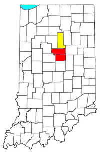
The Kokomo Metropolitan Statistical Area, as defined by the United States Census Bureau
, is an area consisting of two counties in Indiana
, anchored by the city of Kokomo
. As of the 2000 census
, the MSA had a population of 101,541 (though a July 1, 2009 estimate placed the population at 98,787).
.
of 2000, there were 101,541 people, 41,269 households, and 28,307 families residing within the MSA. The racial makeup of the MSA was 91.13% White, 5.50% African American, 0.33% Native American, 0.90% Asian, 0.02% Pacific Islander, 0.76% from other races
, and 1.36% from two or more races. Hispanic or Latino of any race were 1.88% of the population.
The median income for a household in the MSA was $46,017, and the median income for a family was $54,566. Males had a median income of $42,938 versus $25,814 for females. The per capita income
for the MSA was $21,988.
 The Kokomo–Peru
Combined Statistical Area (CSA) is made up of three counties in Indiana. The statistical area includes one metropolitan area
and one micropolitan area
. As of the 2000 Census, the CSA had a population of 137,623 (though a July 1, 2009 estimate placed the population at 134,788).
United States Census Bureau
The United States Census Bureau is the government agency that is responsible for the United States Census. It also gathers other national demographic and economic data...
, is an area consisting of two counties in Indiana
Indiana
Indiana is a US state, admitted to the United States as the 19th on December 11, 1816. It is located in the Midwestern United States and Great Lakes Region. With 6,483,802 residents, the state is ranked 15th in population and 16th in population density. Indiana is ranked 38th in land area and is...
, anchored by the city of Kokomo
Kokomo, Indiana
Kokomo is a city in and the county seat of Howard County, Indiana, United States, Indiana's 13th largest city. It is the principal city of the Kokomo, Indiana Metropolitan Statistical Area, which includes all of Howard and Tipton counties....
. As of the 2000 census
United States Census, 2000
The Twenty-second United States Census, known as Census 2000 and conducted by the Census Bureau, determined the resident population of the United States on April 1, 2000, to be 281,421,906, an increase of 13.2% over the 248,709,873 persons enumerated during the 1990 Census...
, the MSA had a population of 101,541 (though a July 1, 2009 estimate placed the population at 98,787).
Incorporated places
- Cities
- ElwoodElwood, Indiana- Demographics :As of the census of 2000, there were 9,737 people, 3,845 households, and 2,660 families residing in the city. The population density was 2,743.1 people per square mile . There were 4,179 housing units at an average density of 1,177.3 per square mile...
(partial) - KokomoKokomo, IndianaKokomo is a city in and the county seat of Howard County, Indiana, United States, Indiana's 13th largest city. It is the principal city of the Kokomo, Indiana Metropolitan Statistical Area, which includes all of Howard and Tipton counties....
(Principal city) - TiptonTipton, IndianaTipton is a city in and the county seat of Tipton County, Indiana, United States. The population was 5,106 at the 2010 census. It is part of the 'Kokomo, Indiana Metropolitan Statistical Area...
- Elwood
- Towns
- GreentownGreentown, IndianaGreentown is a town in Liberty Township, Howard County, Indiana, United States. The population was 2,415 at the 2010 census. It is part of the Kokomo, Indiana Metropolitan Statistical Area.-Geography:Greentown is located at ....
- KemptonKempton, IndianaKempton is a town in Jefferson Township, Tipton County, Indiana, United States. The population was 335 at the 2010 census. It is part of the Kokomo, Indiana Metropolitan Statistical Area.-Geography:Kempton is located at ....
- RussiavilleRussiaville, IndianaRussiaville is a town in Liberty Township, Howard County, Indiana, United States. The population was 1,094 at the 2010 census. It is part of the Kokomo, Indiana Metropolitan Statistical Area.-Etymology:...
- SharpsvilleSharpsville, IndianaSharpsville is a town in Liberty Township, Tipton County, Indiana, in the United States. It is part of the Kokomo, Indiana Metropolitan Statistical Area. As of the 2010 census, Sharpsville's population is 607.-Geography:...
- Windfall
- Greentown
Census-designated places
Note: All census-designated places are unincorporatedUnincorporated area
In law, an unincorporated area is a region of land that is not a part of any municipality.To "incorporate" in this context means to form a municipal corporation, a city, town, or village with its own government. An unincorporated community is usually not subject to or taxed by a municipal government...
.
- Indian HeightsIndian Heights, IndianaIndian Heights is a census-designated place in Howard County, Indiana, United States. The population was 3,011 at the 2010 census. It is part of the Kokomo, Indiana Metropolitan Statistical Area...
Unincorporated places
|
Hemlock, Indiana Hemlock is an unincorporated town in southern Taylor Township, Howard County, Indiana, United States. It lies at the intersection of State Road 26 with County Road 450E.... Hobbs, Indiana Hobbs is an unincorporated town in Madison Township, Tipton County, Indiana, United States. It is part of the Kokomo, Indiana, Metropolitan Statistical Area.... Jerome, Indiana Jerome is an unincorporated town in Union Township, Howard County, Indiana, United States. It is part of the Kokomo, Indiana Metropolitan Statistical Area.... Judson, Indiana Judson is an unincorporated town in Ervin Township, Howard County, Indiana, United States. It is part of the Kokomo, Indiana Metropolitan Statistical Area.... Nevada, Indiana Nevada is an unincorporated town in Liberty Township, Tipton County, Indiana, United States. It is part of the Kokomo, Indiana Metropolitan Statistical Area.... New London, Indiana New London is an unincorporated town in Monroe Township, Howard County, Indiana, United States. It is part of the Kokomo, Indiana Metropolitan Statistical Area.The old school's nickname was the Quakers.... |
Oakford, Indiana Oakford is an unincorporated town in southwestern Taylor Township, Howard County, Indiana, United States. It lies at a railroad crossing of State Road 26, little more than 1 mile east of State Road 26's intersection with U.S. Route 31.Oakford is part of the Kokomo, Indiana Metropolitan... Phlox, Indiana Phlox is an unincorporated town in southern Union Township, Howard County, Indiana, United States. It lies at the intersection of State Road 26 with County Road 1100 East.Phlox is part of the Kokomo, Indiana Metropolitan Statistical Area.... Plevna, Indiana Plevna is an unincorporated town in Liberty Township, Howard County, Indiana, United States. It is part of the Kokomo, Indiana Metropolitan Statistical Area.... Sycamore, Indiana Sycamore is an unincorporated town in Jackson Township, Howard County, Indiana, United States. It is part of the Kokomo, Indiana Metropolitan Statistical Area.... Tetersburg, Indiana Tetersburg is an unincorporated town in Jefferson Township, Tipton County, Indiana, United States. It is part of the Kokomo, Indiana Metropolitan Statistical Area.... Vermont, Indiana Vermont is an unincorporated community in Howard Township, Howard County, Indiana, United States. It is part of the Kokomo, Indiana Metropolitan Statistical Area.... |
Howard County
|
Jackson Township, Howard County, Indiana Jackson Township is one of eleven townships in Howard County, Indiana, USA. As of the 2010 census, its population was 596.-Adjacent townships:* Jackson Township, Miami County * Richland Township, Grant County... Liberty Township, Howard County, Indiana Liberty Township is one of eleven townships in Howard County, Indiana, USA. As of the 2010 census, its population was 4,862.-Geography:Liberty Township covers an area of ; of this, or 0.77 percent is water.-Adjacent townships:... Monroe Township, Howard County, Indiana Monroe Township is one of eleven townships in Howard County, Indiana, USA. As of the 2010 census, its population was 1,407.-Geography:Monroe Township covers an area of... Taylor Township, Howard County, Indiana Taylor Township is one of eleven townships in Howard County, Indiana, USA. As of the 2010 census, its population was 9,294.-Geography:Taylor Township covers an area of... Union Township, Howard County, Indiana Union Township is one of eleven townships in Howard County, Indiana, USA. As of the 2010 census, its population was 1,029.-Geography:Union Township covers an area of ; of this, or 0.13 percent is water.-Unincorporated towns:* Jerome* Phlox... |
Tipton County
- CiceroCicero Township, Tipton County, IndianaCicero Township is one of six townships in Tipton County, Indiana, USA. As of the 2000 census, its population was 8,350.-Geography:According to the United States Census Bureau, Cicero Township covers an area of .-Unincorporated towns:* Jacksons at...
- JeffersonJefferson Township, Tipton County, IndianaJefferson Township is one of six townships in Tipton County, Indiana, USA. As of the 2000 census, its population was 1,486.-Geography:According to the United States Census Bureau, Jefferson Township covers an area of .-Unincorporated towns:...
- LibertyLiberty Township, Tipton County, IndianaLiberty Township is one of six townships in Tipton County, Indiana, USA. As of the 2000 census, its population was 2,569.-Geography:According to the United States Census Bureau, Liberty Township covers an area of .-Unincorporated towns:* Nevada at...
- MadisonMadison Township, Tipton County, IndianaMadison Township is one of six townships in Tipton County, Indiana, USA. As of the 2000 census, its population was 1,414.-Geography:According to the United States Census Bureau, Madison Township covers an area of .-Unincorporated towns:* Curtisville at...
- PrairiePrairie Township, Tipton County, IndianaPrairie Township is one of six townships in Tipton County, Indiana, USA. As of the 2000 census, its population was 1,213.-Geography:According to the United States Census Bureau, Prairie Township covers an area of .-Unincorporated towns:* Groomsville at...
- WildcatWildcat Township, Tipton County, IndianaWildcat Township is one of six townships in Tipton County, Indiana, USA. As of the 2000 census, its population was 1,545.-Geography:According to the United States Census Bureau, Wildcat Township covers an area of ; of this, is land and is water.-Adjacent townships:* Union Township, Howard...
Demographics
As of the censusCensus
A census is the procedure of systematically acquiring and recording information about the members of a given population. It is a regularly occurring and official count of a particular population. The term is used mostly in connection with national population and housing censuses; other common...
of 2000, there were 101,541 people, 41,269 households, and 28,307 families residing within the MSA. The racial makeup of the MSA was 91.13% White, 5.50% African American, 0.33% Native American, 0.90% Asian, 0.02% Pacific Islander, 0.76% from other races
Race (United States Census)
Race and ethnicity in the United States Census, as defined by the Federal Office of Management and Budget and the United States Census Bureau, are self-identification data items in which residents choose the race or races with which they most closely identify, and indicate whether or not they are...
, and 1.36% from two or more races. Hispanic or Latino of any race were 1.88% of the population.
The median income for a household in the MSA was $46,017, and the median income for a family was $54,566. Males had a median income of $42,938 versus $25,814 for females. The per capita income
Per capita income
Per capita income or income per person is a measure of mean income within an economic aggregate, such as a country or city. It is calculated by taking a measure of all sources of income in the aggregate and dividing it by the total population...
for the MSA was $21,988.
Combined Statistical Area
Peru, Indiana
-Demographics:As of the census of 2000, there were 12,994 people, 5,410 households, and 3,397 families residing in the city. The population density was 2,815.5 people per square mile . There were 5,943 housing units at an average density of 1,287.7 per square mile...
Combined Statistical Area (CSA) is made up of three counties in Indiana. The statistical area includes one metropolitan area
United States metropolitan area
In the United States a metropolitan statistical area is a geographical region with a relatively high population density at its core and close economic ties throughout the area. Such regions are not legally incorporated as a city or town would be, nor are they legal administrative divisions like...
and one micropolitan area
United States micropolitan area
United States Micropolitan Statistical Areas , as defined by the United States Office of Management and Budget, are urban areas in the United States based around a core city or town with a population of 10,000 to 49,999. The micropolitan area designation was created in 2003...
. As of the 2000 Census, the CSA had a population of 137,623 (though a July 1, 2009 estimate placed the population at 134,788).
Components
- Metropolitan Statistical Areas (MSAs)
- Kokomo (Howard and Tipton counties)
- Micropolitan Statistical Areas (μSA)
- Peru (Miami CountyMiami County, IndianaAs of the census of 2000, there were 36,082 people, 13,716 households, and 9,806 families residing in the county. The population density was 96 people per square mile . There were 15,299 housing units at an average density of 41 per square mile...
)
- Peru (Miami County