
Thailand Route 401
Encyclopedia
Thailand Route 401 is a highway in southern
Thailand
. It starts from the west coast of the Thai-Malay Peninsula at an intersection with Route 4 near Amphoe
Takua Pa
, Phang Nga Province
.
The route runs eastward through Surat Thani Province
to the east coast, then southward to Nakhon Si Thammarat Province
. It ends at Ban Tha Pae, about 10 km north of Nakhon Si Thammarat
town. Route 4012
then connects Ban Tha Pae to Nakhon Si Thammarat town.
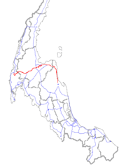 Route 401 is the main road that connects Surat Thani and Nakhon Si Thammarat. It starts near Amphoe Takua Pa
as a two-lane single carriageway
. Running eastward, it passes through Amphoe Phanom
, Amphoe Ban Ta Khun
to Amphoe Phunphin. Then it widens to a four-lane double carriageway and continues to Surat Thani, Amphoe Kanchanadit
. It enters Nakhon Si Thammarat province at Amphoe Khanom
, but does not pass the town of Khanom. It, then, goes southward pass Amphoe Sichon
, Amphoe Tha Sala
and ends at Ban Tha Pae, about 10 km north of Nakhon Si Thammarat. Total length is 287.682 km. Of this, 23.628 km is in Phang Nga Province, 186.458 km in Surat Thani Province and 77.596 km in Nakhon Si Thammarat Province.
Most of the route is asphalt. However, a short section from Phun Phin till the start of the Surat Thani bypass is concrete. Almost all of the four-lane section is divided highway
, with the exception of short sections at Ban Ton Reang and Ban Tha Pae.
From Amphoe Phunphin to Amphoe Khanom, the route crosses many hills. The highest is Khao Hua Chang, a few kilometers before the intersection with Route 4014. About 1 km east of Khao Hua Chang, the route expand to six lanes, with the outermost lane for slow vehicles such as trucks. Between Amphoe Sichon and Ban Tha Pae, it's mostly level. At Amphoe Tha Sala, the route runs very near the coast (10–50 m) for about 2 km. This is the only section of Route 401 that runs adjacent to the sea.
The section of Route 401 between the intersection with Route 4008 near Amphoe Phun Phin and the intersection with Route 4103 near Ban Tha Pae was once heavily used as a main access route to Bangkok for the lower southern provinces. However, when a new section of Route 41
between Phunphin and Thungsong was finished, the majority of traffic has moved to the new route.
There are two bypasses on Route 401, around Surat Thani (10.282 km) and Tha Sala (4.27 km).
Southern Thailand
Southern Thailand is a distinct region of Thailand, connected with the Central region by the narrow Kra Isthmus.-Geography:Southern Thailand is located on the Malay Peninsula, with an area around 70,713 km², bounded to the north by Kra Isthmus as the narrowest part of the peninsula. The...
Thailand
Thailand
Thailand , officially the Kingdom of Thailand , formerly known as Siam , is a country located at the centre of the Indochina peninsula and Southeast Asia. It is bordered to the north by Burma and Laos, to the east by Laos and Cambodia, to the south by the Gulf of Thailand and Malaysia, and to the...
. It starts from the west coast of the Thai-Malay Peninsula at an intersection with Route 4 near Amphoe
Amphoe
An amphoe is the second level administrative subdivision of Thailand. Usually translated as district, amphoe make up the provinces, and are analogous to a county seat...
Takua Pa
Amphoe Takua Pa
Takua Pa ) is a district in the province Phang Nga in the south of Thailand.-Geography:The district is located at the coast to the Andaman Sea. To the north of the district is the Si Phang-nga National Park...
, Phang Nga Province
Phang Nga Province
Phang Nga is one of the southern provinces of Thailand, on the shore to the Andaman Sea. Neighboring provinces are Ranong, Surat Thani and Krabi. To the south is the Phuket province, but without land boundary to Phang Nga....
.
The route runs eastward through Surat Thani Province
Surat Thani Province
Surat Thani is the largest of the southern provinces of Thailand, on the eastern shore of the Gulf of Thailand. Surat Thani means City of Good People, the title given to the city by King Vajiravudh ....
to the east coast, then southward to Nakhon Si Thammarat Province
Nakhon Si Thammarat Province
Nakhon Si Thammarat is one of the southern provinces of Thailand, at the eastern shore of the Gulf of Thailand...
. It ends at Ban Tha Pae, about 10 km north of Nakhon Si Thammarat
Nakhon Si Thammarat
Nakhon Si Thammarat is a town in southern Thailand, capital of the Nakhon Si Thammarat Province and the Nakhon Si Thammarat district. It is about south of Bangkok, on the east coast of the Malay Peninsula. The city was the administrative center of southern Thailand during most of its history. ...
town. Route 4012
Thailand Route 4012
Route 4012 is a short route between Ban Tha Pae and Nakhon Si Thammarat Town. Its length is about 8 km.-Route Details:Route 4012 start at Ban Tha Pae, exactly the point Route 401 ends. It run southward to Nakhon Si Thammarat Town. It is 4-lane asphalt, 2 in each direction separated by a...
then connects Ban Tha Pae to Nakhon Si Thammarat town.
Route Details
Amphoe Takua Pa
Takua Pa ) is a district in the province Phang Nga in the south of Thailand.-Geography:The district is located at the coast to the Andaman Sea. To the north of the district is the Si Phang-nga National Park...
as a two-lane single carriageway
Single carriageway
A single carriageway is a road with 1, 2 or more lanes arranged within a single carriageway with no central reservation to separate opposing flows of traffic. Two-lane road or two-lane highway are single carriageway with one lane for each direction...
. Running eastward, it passes through Amphoe Phanom
Amphoe Phanom
Phanom is a district in the southwest of Surat Thani Province of southern Thailand.-Geography:The district is located within the hills of the Phuket mountain range, with around 60% of the area consisting of mountains and forests. The northwestern part of the district is protected in the Khao Sok...
, Amphoe Ban Ta Khun
Amphoe Ban Ta Khun
Ban Ta Khun is a district in the west of Surat Thani Province of southern Thailand. It is both the largest district of the province areawise as well as the one with the lowest population density.-Geography:...
to Amphoe Phunphin. Then it widens to a four-lane double carriageway and continues to Surat Thani, Amphoe Kanchanadit
Amphoe Kanchanadit
Kanchanadit is a district in the province Surat Thani in the south of Thailand.-History:Originally the town was named Thathong and was located at the shore of Khlong Thathong Mai . During the reign of King Nangklao the town was moved because its location was malaria-infested, and renamed to...
. It enters Nakhon Si Thammarat province at Amphoe Khanom
Amphoe Khanom
Khanom is the northernmost district of Nakhon Si Thammarat Province, southern Thailand.-Geography:The district is located in the north of the province. To the west is Surat Thani Province, while to the north and east is the Gulf of Thailand...
, but does not pass the town of Khanom. It, then, goes southward pass Amphoe Sichon
Amphoe Sichon
Sichon is a district of Nakhon Si Thammarat Province, southern Thailand.-Geography:The district is located in the northern part of the province. Neighboring districts are Tha Sala and Nopphitam of Nakhon Si Thammarat Province, Kanchanadit and Don Sak of Surat Thani Province, and Khanom of Nakhon...
, Amphoe Tha Sala
Amphoe Tha Sala
Tha Sala is a district of Nakhon Si Thammarat Province, southern Thailand.-Geography:Neighboring districts are Mueang Nakhon Si Thammarat, Phrom Khiri, Nopphitam and Sichon...
and ends at Ban Tha Pae, about 10 km north of Nakhon Si Thammarat. Total length is 287.682 km. Of this, 23.628 km is in Phang Nga Province, 186.458 km in Surat Thani Province and 77.596 km in Nakhon Si Thammarat Province.
Most of the route is asphalt. However, a short section from Phun Phin till the start of the Surat Thani bypass is concrete. Almost all of the four-lane section is divided highway
Divided Highway
Divided Highway is a compilation album by American rock band The Doobie Brothers, released in 2003. . All tracks are taken from the albums Cycles and Brotherhood .-Track listing:...
, with the exception of short sections at Ban Ton Reang and Ban Tha Pae.
From Amphoe Phunphin to Amphoe Khanom, the route crosses many hills. The highest is Khao Hua Chang, a few kilometers before the intersection with Route 4014. About 1 km east of Khao Hua Chang, the route expand to six lanes, with the outermost lane for slow vehicles such as trucks. Between Amphoe Sichon and Ban Tha Pae, it's mostly level. At Amphoe Tha Sala, the route runs very near the coast (10–50 m) for about 2 km. This is the only section of Route 401 that runs adjacent to the sea.
The section of Route 401 between the intersection with Route 4008 near Amphoe Phun Phin and the intersection with Route 4103 near Ban Tha Pae was once heavily used as a main access route to Bangkok for the lower southern provinces. However, when a new section of Route 41
Thailand Route 41
Route 41 starts at intersection with Route 4 in Chumphon Province. It goes southward passing through Surat Thani Province and Nakhon Si Thammarat Province. It ends at Phatthalung Province joining Route 4 again.-Route Details:...
between Phunphin and Thungsong was finished, the majority of traffic has moved to the new route.
There are two bypasses on Route 401, around Surat Thani (10.282 km) and Tha Sala (4.27 km).
Phang Nga Province
-
- (Start) Route 4Phetkasem highwayPhetkasem Road or Thailand Route 4 is one of the four major highways in Thailand, along with Phahonyothin Road , Mittraphap Road , and Sukhumvit Road . At 1,274 km, it is the longest highway in Thailand. It begins at Naowa Chamnian bridge in Bangkok Yai, Bangkok...
(north to Ranong ProvinceRanong ProvinceRanong is one of the southern provinces of Thailand, on the coast of the Andaman Sea. It is the province with the fewest citizens. Neighboring provinces are Chumphon, Surat Thani and Phang Nga...
, south to Phang Nga ProvincePhang Nga ProvincePhang Nga is one of the southern provinces of Thailand, on the shore to the Andaman Sea. Neighboring provinces are Ranong, Surat Thani and Krabi. To the south is the Phuket province, but without land boundary to Phang Nga....
, Phuket ProvincePhuket ProvincePhuket , formerly known as Thalang and, in Western sources, Junk Ceylon , is one of the southern provinces of Thailand...
) - Route 4090 (south to Amphoe KapongAmphoe KapongKapong is a district in the province Phang Nga in the south of Thailand.-Geography:Neighboring districts are Phanom of Surat Thani Province, Mueang Phang Nga, Thai Mueang and Takua Pa....
)
- (Start) Route 4
Surat Thani Province
-
- Route 4118 (south to Amphoe Thap PutAmphoe Thap PutThap Phut is a district in the province Phang Nga in the south of Thailand.-History:In 1785 Burmese troops attacked Mueang Thalang. The inhabitants escaped from Thalang to the area of modern-day Thap Put. They built shelter that in southern Thai language are called Thap...
) - Route 415 (south to Phang Nga Province)
- Route 41Thailand Route 41Route 41 starts at intersection with Route 4 in Chumphon Province. It goes southward passing through Surat Thani Province and Nakhon Si Thammarat Province. It ends at Phatthalung Province joining Route 4 again.-Route Details:...
(north to Chumphon ProvinceChumphon ProvinceChumphon ) is one of the southern provinces of Thailand, at the shore of the Gulf of Thailand. Neighboring provinces are Prachuap Khiri Khan, Surat Thani and Ranong...
, south to Trang ProvinceTrang ProvinceTrang is one of the southern provinces of Thailand, at the western shore of the Malay Peninsula to the Andaman Sea. Neighboring provinces are Krabi, Nakhon Si Thammarat, Phatthalung and Satun....
, Krabi ProvinceKrabi ProvinceKrabi is one of the southern provinces of Thailand, at the shore of the Andaman Sea. Neighbouring provinces are Phang Nga, Surat Thani, Nakhon Si Thammarat and Trang. The Phuket province to the west is also neighbouring, but without any land boundary...
) - Route 4008 (west to Amphoe Phunphin)
- Route 417 (north to Surat Thani AirportSurat Thani AirportSurat Thani Airport is situated in the Phunphin district, Surat Thani province, Thailand. The airport, which is located 21 km west of Surat Thani, is also the Wing 7 Airforce base...
- Route 4009 (south to Amphoe Ban Na DoemAmphoe Ban Na Doem-Geography:Ban Na Doem is located in the center of Surat Thani province. Neighboring district are Mueang Surat Thani, Ban Na San, Khian Sa and Phunphin.The Tapi River forms part of the western boundary of the district...
, Amphoe Ban Na SanAmphoe Ban Na San-Geography:Neighboring districts are Nopphitam and Phipun of Nakhon Si Thammarat Province, Wiang Sa, Khian Sa, Ban Na Doem, Mueang Surat Thani and Kanchanadit....
) - Route 44Thailand Route 44Route 44 is part of land bridge project. It starts at intersection with Route 4 in Krabi Province, running northeast, and ends at intersection with Route 401 in Surat Thani Province.-Route Details:...
(south to Trang Province, Krabi Province) - Route 4142 (north to Amphoe Don SakAmphoe Don SakDon Sak is a district in eastern Surat Thani Province. The ferry port to Samui Island is located in the district.Neighboring districts are Khanom and Sichon and the district Kanchanadit...
, ferry pier to Ko SamuiKo SamuiKo Samui island of Surat Thani Province , or often, simply Samui as it is referred to by locals, is an island off the east coast of the Kra Isthmus in Thailand, close to the mainland Surat Thani town. It is Thailand's second largest island, with an area of 228.7 km2 and a population of over...
)
- Route 4118 (south to Amphoe Thap Put
Nakhon Si Thammarat Province
-
- Route 4014 (north to Amphoe KhanomAmphoe KhanomKhanom is the northernmost district of Nakhon Si Thammarat Province, southern Thailand.-Geography:The district is located in the north of the province. To the west is Surat Thani Province, while to the north and east is the Gulf of Thailand...
) - Route 4140 (west to Amphoe NopphitamAmphoe NopphitamNopphitam is a district of Nakhon Si Thammarat Province, southern Thailand.-History:The district was created on April 1, 1995 by splitting off the four western tambon from Tha Sala district....
, east to Amphoe Tha SalaAmphoe Tha SalaTha Sala is a district of Nakhon Si Thammarat Province, southern Thailand.-Geography:Neighboring districts are Mueang Nakhon Si Thammarat, Phrom Khiri, Nopphitam and Sichon...
) - Route 4103 (south to Phatthalung ProvincePhatthalung ProvincePhatthalung is one of the southern provinces of Thailand. Neighboring provinces are Nakhon Si Thammarat, Songkhla, Satun and Trang.-Geography:...
) - (End) Route 4012Thailand Route 4012Route 4012 is a short route between Ban Tha Pae and Nakhon Si Thammarat Town. Its length is about 8 km.-Route Details:Route 4012 start at Ban Tha Pae, exactly the point Route 401 ends. It run southward to Nakhon Si Thammarat Town. It is 4-lane asphalt, 2 in each direction separated by a...
(south to Nakhon Si Thammarat)
- Route 4014 (north to Amphoe Khanom