

Amphoe Kapong
Encyclopedia
Kapong is a district (amphoe
) in the province Phang Nga
in the south of Thailand
.
of Surat Thani Province
, Mueang Phang Nga
, Thai Mueang
and Takua Pa
.
The forests of the district are part of the Khao Lak-Lam Ru National Park.
), which are further subdivided into 22 villages (muban
). Tha Na has township (thesaban tambon) status and covers parts of the tambon Tha Na. There are four Tambon administrative organization (TAO), tambon Kapong is administrated by a neighboring tambon.
Amphoe
An amphoe is the second level administrative subdivision of Thailand. Usually translated as district, amphoe make up the provinces, and are analogous to a county seat...
) in the province Phang Nga
Phang Nga Province
Phang Nga is one of the southern provinces of Thailand, on the shore to the Andaman Sea. Neighboring provinces are Ranong, Surat Thani and Krabi. To the south is the Phuket province, but without land boundary to Phang Nga....
in the south of Thailand
Thailand
Thailand , officially the Kingdom of Thailand , formerly known as Siam , is a country located at the centre of the Indochina peninsula and Southeast Asia. It is bordered to the north by Burma and Laos, to the east by Laos and Cambodia, to the south by the Gulf of Thailand and Malaysia, and to the...
.
Geography
Neighboring districts are (from the north clockwise) PhanomAmphoe Phanom
Phanom is a district in the southwest of Surat Thani Province of southern Thailand.-Geography:The district is located within the hills of the Phuket mountain range, with around 60% of the area consisting of mountains and forests. The northwestern part of the district is protected in the Khao Sok...
of Surat Thani Province
Surat Thani Province
Surat Thani is the largest of the southern provinces of Thailand, on the eastern shore of the Gulf of Thailand. Surat Thani means City of Good People, the title given to the city by King Vajiravudh ....
, Mueang Phang Nga
Amphoe Mueang Phang Nga
Mueang Phang Nga is the capital district of Phang Nga Province in southern Thailand.-Geography:Neighboring districts are Thap Put, Phanom of Surat Thani Province, Kapong, Thai Mueang and Takua Thung. To the south is the Phang Nga bay, with the insular district Ko Yao.The Ao Phang Nga National...
, Thai Mueang
Amphoe Thai Mueang
Thai Mueang is a district in the province Phang Nga in the south of Thailand.-Geography:Neighboring districts are Takua Pa, Kapong, Mueang Phang Nga and Takua Thung. To the west is the Andaman Sea....
and Takua Pa
Amphoe Takua Pa
Takua Pa ) is a district in the province Phang Nga in the south of Thailand.-Geography:The district is located at the coast to the Andaman Sea. To the north of the district is the Si Phang-nga National Park...
.
The forests of the district are part of the Khao Lak-Lam Ru National Park.
Administration
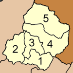
The district Kapong is subdivided into 5 subdistricts (tambonTambon
Tambon is a local government unit in Thailand. Below district and province , they form the third administrative subdivision level. As of the 2009 there are 7255 tambon, not including the 169 khwaeng of Bangkok, which are set at the same administrative level, thus every district contains 8-10 tambon...
), which are further subdivided into 22 villages (muban
Muban
Muban is the lowest administrative subdivision of Thailand. Usually translated as village, they are the subdivision of tambon. As of 2008, there are 74944 administrative villages in Thailand. As of the 1990 census, the average village consisted of 144 households or 746 persons.A muban does not...
). Tha Na has township (thesaban tambon) status and covers parts of the tambon Tha Na. There are four Tambon administrative organization (TAO), tambon Kapong is administrated by a neighboring tambon.
|
 |